
Landscape Evolution and Characteristics of the Dyke-Pond Polder Under Land Consolidation in Huzhou, Zhejiang Province
|
WU Di is a Ph.D. candidate in the School of Landscape Architecture, Beijing Forestry University. Her research focuses on landscape planning and design |
|
CUI Ziqi is a Ph.D. candidate in the School of Landscape Architecture, Beijing Forestry University. Her research focuses on landscape planning and design |
|
GUO Wei, Ph.D., is a professor in the School of Landscape Architecture, Beijing Forestry University, an editorial board member of this journal. His research focuses on landscape planning and design |
Received date: 2025-03-29
Revised date: 2025-12-06
Online published: 2026-03-12
Copyright
The unique polder landscape formed through a series of artificial interventions of “water conservancy-agriculture-settlement” in low-lying water network areas is a living heritage that continues to evolve through the interaction between humans and the land. Since 1970, climate change and socio-economic development have driven the implementation of land consolidation in China, such as linking polders and land levelling, which have significantly changed the scale, structure and organization of polders, resulting in a spatial transformation of the dyke-pond polders in Huzhou from small polders to standardized large polders. The landscape transformation triggered by land consolidation far exceeds urbanization, to a certain extent, causing the polder landscape to lose its diversity, territoriality and continuity.
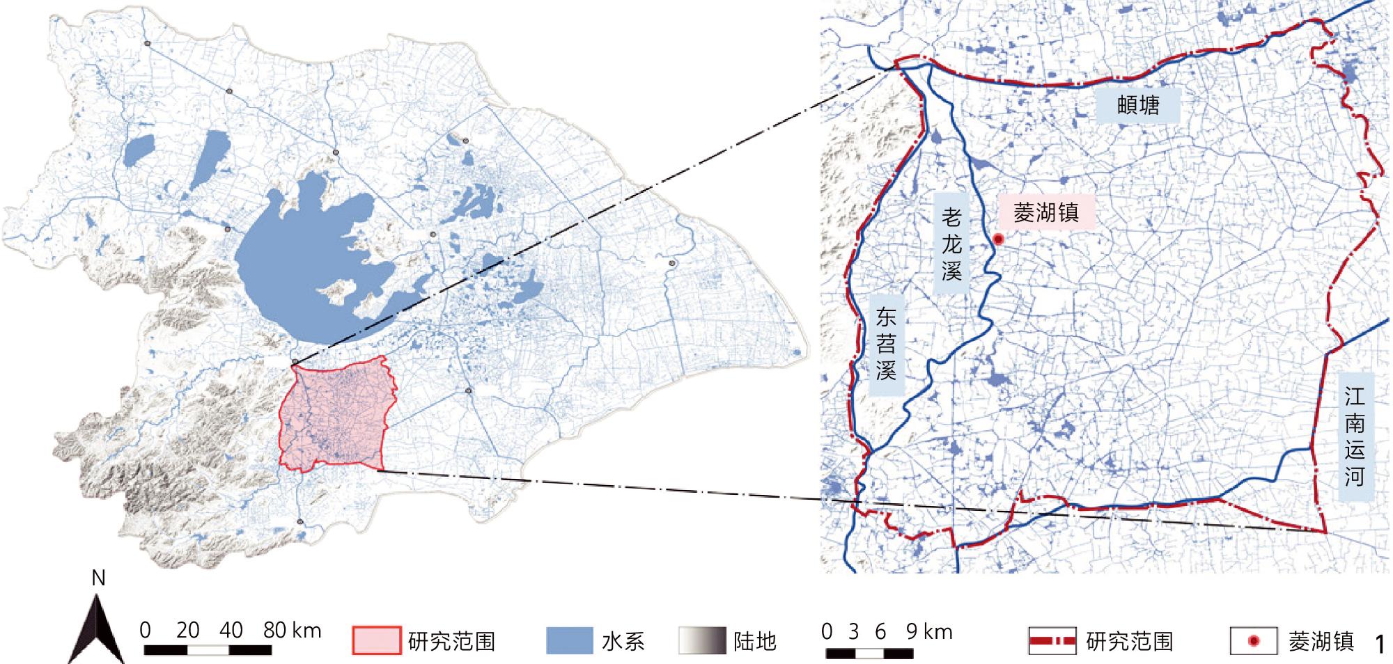
Taking the dyke-pond polder system in the Yangtze River Delta as an example, this study adopts a multi-scale framework combining parameterization and mapping analysis to reveal the spatial and temporal evolution patterns and mechanisms of the polder landscapes in the period of 1970−2020. Firstly, based on historical documents and field surveys, the spatial interpretation of land consolidation measures and processes is carried out, and a multi-temporal polder spatial database covering the three key stages of land consolidation is constructed through the GIS platform. Secondly, a landscape evolution evaluation model is constructed at the regional scale to analyse and quantify the land consolidation measures and landscape changes in hydrological, agricultural and settlement systems at the regional scale. Then, at the unit scale, Mapping was used to extract typological characteristics and reorganization patterns of dyke-pond polder (DPP) landscape elements. Finally, the mechanism of polder landscape evolution under the influence of land consolidation is revealed, and adaptive protection and development strategies for polder cultural landscape are proposed.
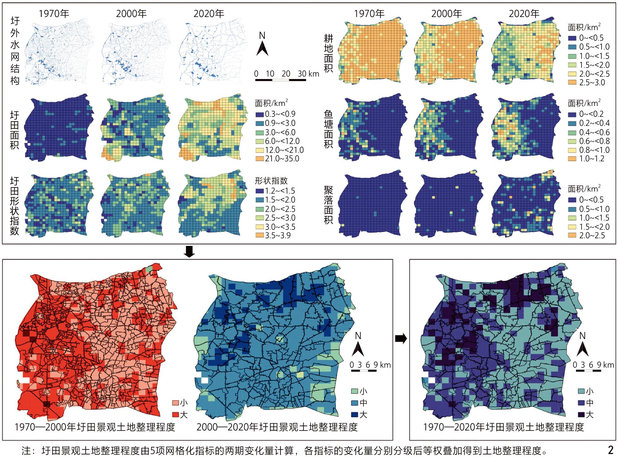
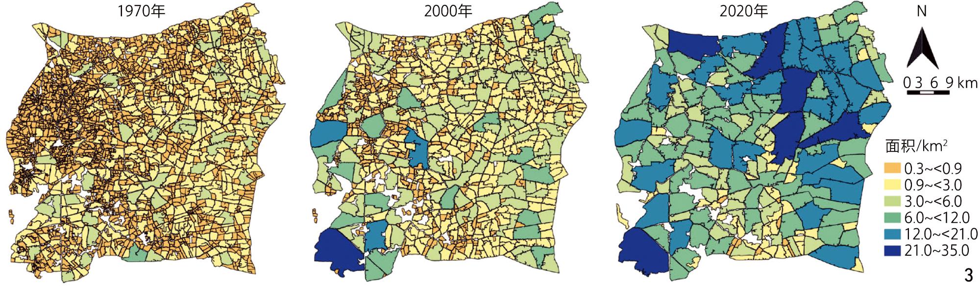
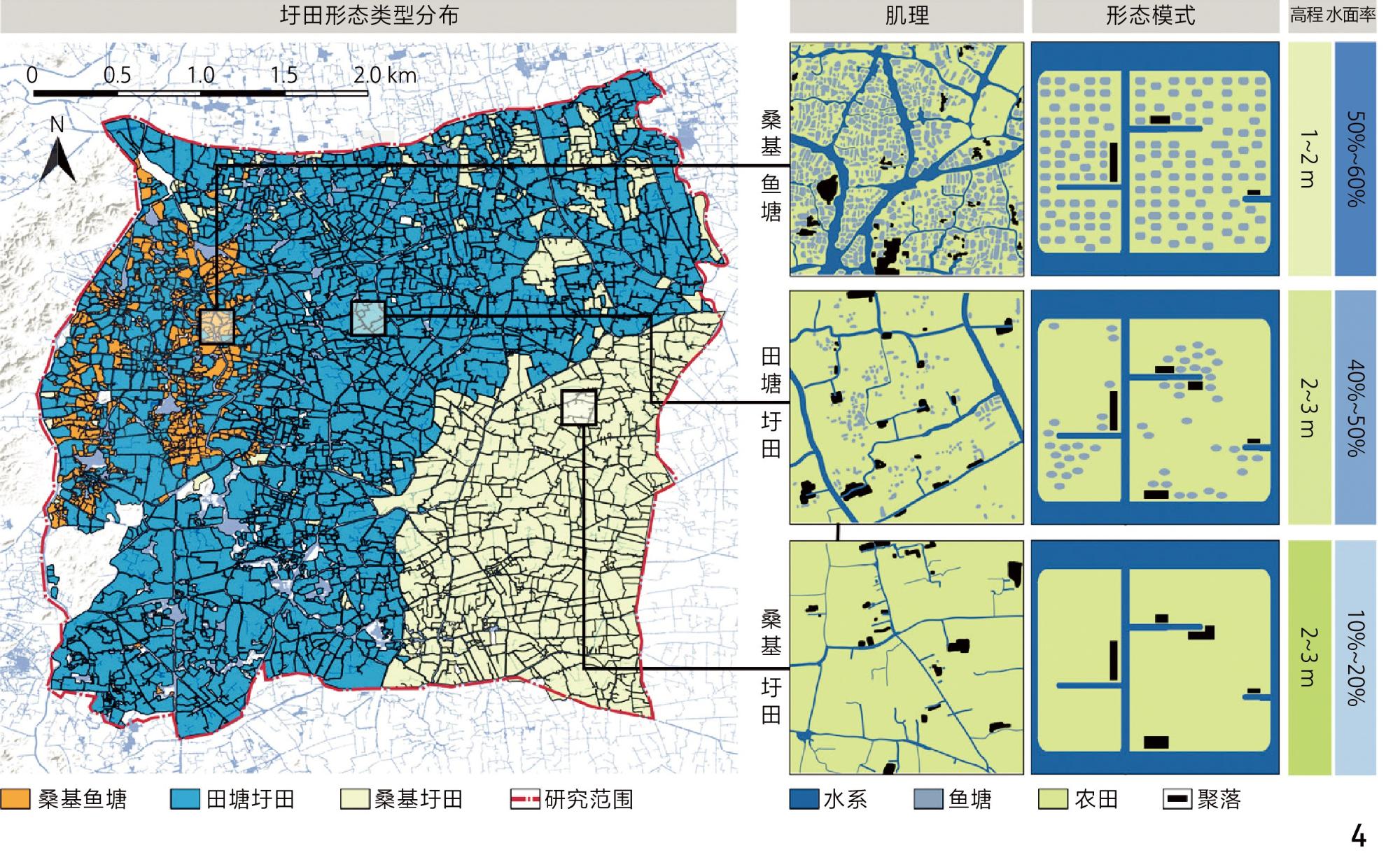
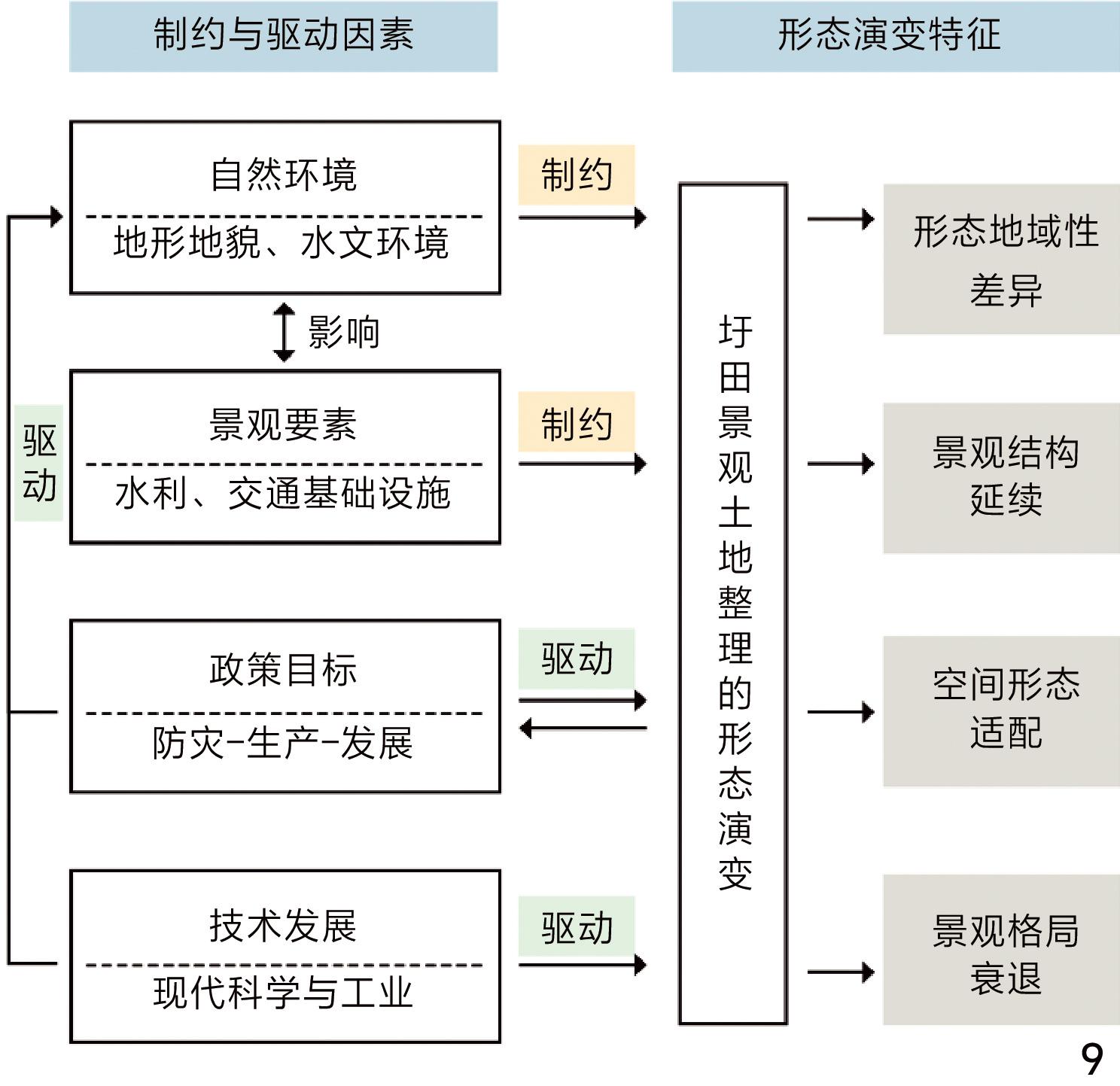
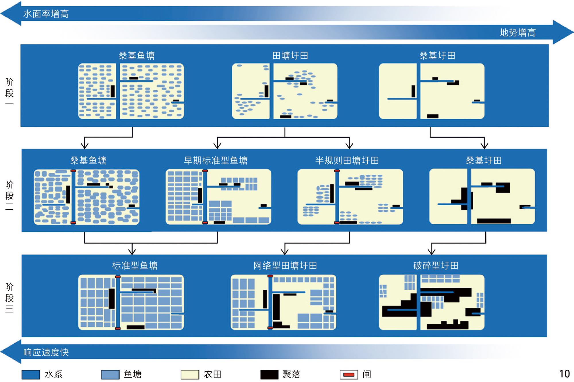
The study found that land consolidation and organisation measures encompass multiple dimensions of water, agricultural and settlements. Depending on the extent of their transformation of the landscape, they can be divided into three phases: 1949−1978, 1979−2000 and 2001−2020. In the time-series dimension, the linking polders project simplified the structure of the water network outside the polder units, resulting in a 44% reduction in water network area. The number of polders decreased from 2,871 to 171, with the average area increasing 18-fold (from 0.42 km2 to 7.5 km2); arable land shrinking accelerated due to the expansion of fishponds and settlement agglomeration. The spatial dimension shows a gradient of response with dramatic transformation in the western low-lying areas and progressive evolution in the southeastern plains. From 1970 to 2000, farmland and ponds tended to be centralized, fishponds gradually expanded, and farmland was transformed into a multilevel grid. From 2000 to 2020, with the popularity of hardened pond embankments and standardized fishponds, the ecological cycle of the dyke-pond polder weakened, and the pond-to-base ratio dropped to 1︰9. In addition, mulberry forests continued to decline, and the expansion of the colony was dramatic, with the farmland patterns becoming increasingly fragmented. The original three types of dyke-pond polder system: Mulberry-dyke fishponds, field-pond polder and mulberry-dyke polder are gradually transformed to standardized fishponds, networked mulberry-dyke polder, and fragmented polder. The mechanism analysis shows that the policy “disaster prevention-production-development” goal progressively drives the transformation of the polder landscape from naturalisation to homogenization to fragmentation. The evolution of polder landscape is the result of the dynamic game between rigid policy intervention and flexible natural adaptation, with obvious spatial differentiation characteristics, such as the differentiation of polder area, the differentiation of settlement expansion, etc., which can be generally summarised as the dramatic transformation of the low-lying areas, and the gradual response of the plains. The historical linear elements such as water networks and dykes, are the genes of polder fields, which constrain the division of land parcels through the layered accumulation effect. However, production-oriented intensification gradually disintegrates the polder gene, leading to the decline of the long-evolved “water-field-village” pattern and the disruption of the synergy between nature and culture.
Based on this, the study proposes an adaptive conservation strategy with opportunity constraints and drivers. Protecting water resources and other elements that are coherently and sustainable in the spatial transformation of polder fields, and reintegrates historical water facilities into the daily lives of the people of the region by giving them new functions. Focusing on natural constraints and policy leadership, designating protected areas and coordinated development zones according to regional characteristics. Develop ecological agriculture, cultural tourism and other landscape industrialization paths to achieve a balance between industrial development and agricultural landscape protection. In the face of cultural fragmentation, the agricultural landscape formed through long-term historical evolution should be used as the foundation for building a systematic polder cultural landscape network. This research aims to provide scientific and reliable decision support for the inheritance of the characteristics and adaptive development of the polder landscape under climatic and socio-economic pressures, and to provide a transferable framework for the spatial evolution research and conservation development of other cultural landscapes.
WU Di , CUI Ziqi , GUO Wei . Landscape Evolution and Characteristics of the Dyke-Pond Polder Under Land Consolidation in Huzhou, Zhejiang Province[J]. Landscape Architecture, 2026 , 33(1) : 124 -132 . DOI: 10.3724/j.fjyl.LA20250201
表1 研究尺度Tab. 1 Research scale |
| 尺度层级 | 比例尺 | 分析尺度 | 研究内容 |
|---|---|---|---|
| 区域尺度 | 1︰50 000 | 地理网格、圩田单元 | 土地利用演变与空间分异 |
| 单元尺度 | 1︰5 000 | 景观要素 | 单元景观要素形态 |
表3 水利、农业及聚落景观演变数据Tab. 3 Data on the hydrological, agricultural and settlement landscape evolution |
| 年份 | 演变指标 | |||||
|---|---|---|---|---|---|---|
| 圩外水面积/km2 | 圩堤与田面高差/m | 圩堤长度/km | 圩田数量 | 圩田平均面积/km2 | 聚落总面积/km2 | |
| 1970 | 200.6 | 0.5 | 7 762.4 | 2 871 | 0.4 | 47 |
| 2000 | 165.9 | 1.0~3.0 | 4 850.6 | 818 | 1.5 | 86 |
| 2020 | 120.8 | 1.0~3.0 | 2 804.9 | 171 | 7.5 | 244 |
表2 圩田景观土地整理措施与指标Tab. 2 Land consolidation measures and indicators for polders |
| 景观类型 | 土地整理措施 | 被影响的景观特征 | 景观特征指标 |
|---|---|---|---|
| 注:—代表无对应指标。 | |||
| 水利景观 | 联圩并圩、圩内河网重建 | 水网结构 | 圩外水网结构 |
| 农业景观 | 土地平整、农用地整合 | 圩田大小与形态 | 圩田面积 |
| 圩田形状指数 | |||
| 农用地格局 | 耕地面积 | ||
| 鱼塘面积 | |||
| 聚落景观 | 聚落搬迁 | 聚落分布 | — |
| 聚落规模 | 聚落面积 | ||
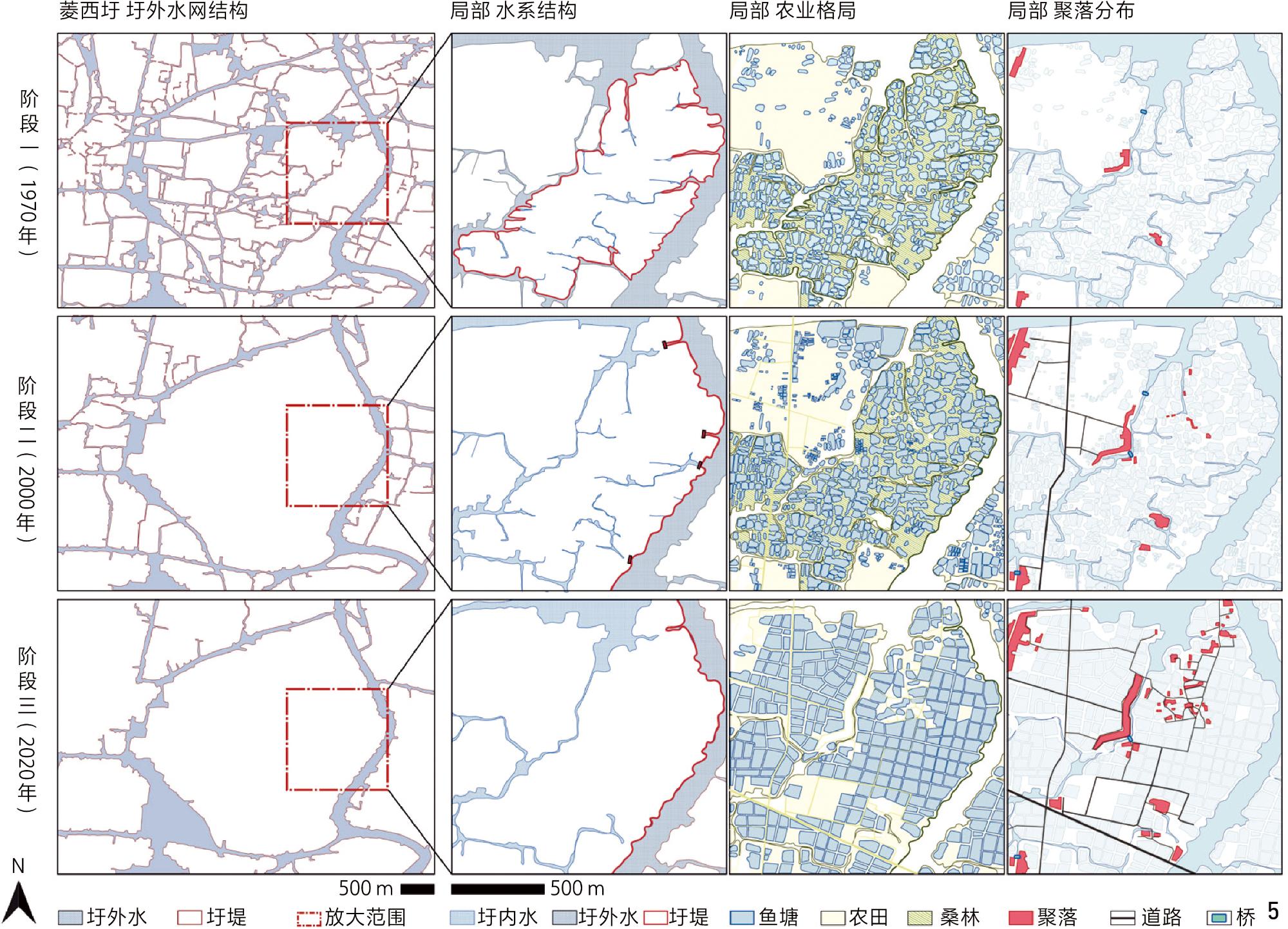
图5 桑基鱼塘典型案例菱西圩肌理演变Fig. 5 Texture evolution of Lingxiwei, a typical case of mulberry-dyke fish-pond |
表4 桑基鱼塘的演化特征[24, 26, 28-30]Tab. 4 Evolutionary characteristics of the mulberry-dyke fishponds[24, 26, 28-30] |
| 阶段 (代表年份) | 圩田类型 | 水利景观特征 | 农业景观特征 | 聚落景观特征 |
|---|---|---|---|---|
| 注:a)1970—2000年,东林圩将1950年的30只小圩最终合并为一个,圩堤总长由64 km缩减为18.7 km[24],菱西圩内68只小圩圩堤总长由92 km缩减为17.5 km。b)2000—2020年,除湖州桑基鱼塘系统农业文化遗产核心保护区[29]仍保留桑基鱼塘模式与肌理外,其余地区全部完成联圩并圩。 | ||||
| 阶段一(1970) | 桑基鱼塘 | 圩内水网为简单圩溇 | 圩田单元平均面积约8.15 hm2,呈不规则自然形; 鱼塘(平均0.15 hm2)呈近椭圆形; 塘基比为2︰3~3︰2[26] | 选址于塘路支河高墩 |
| 阶段二(2000) | 桑基鱼塘 | 率先联圩,圩堤长度锐减a); 圩外水系保留并转化为圩内骨干水网; 部分圩内河道改为鱼塘[28] | 旧有圩田单元形状基本不变; 塘基变窄甚至退化; 鱼塘扩张; 鱼塘(平均0.37 hm2)呈近矩形; 塘基比略有提高 | 受空间限制,聚落扩张不显著 |
| 阶段三(2020) | 标准型 鱼塘 | 全部完成联圩并圩b); 圩田单元圩堤由自然转为人工; 堤上埋置鱼塘涵管,堤间设置塘间明渠[24],鱼塘与圩内水网相连 | 鱼塘继续扩张; 鱼塘(平均0.78 hm2)呈规则矩形; 塘基比为9︰1 | 高墩聚落一定程度扩张; 基堤聚落搬迁合并[30] |
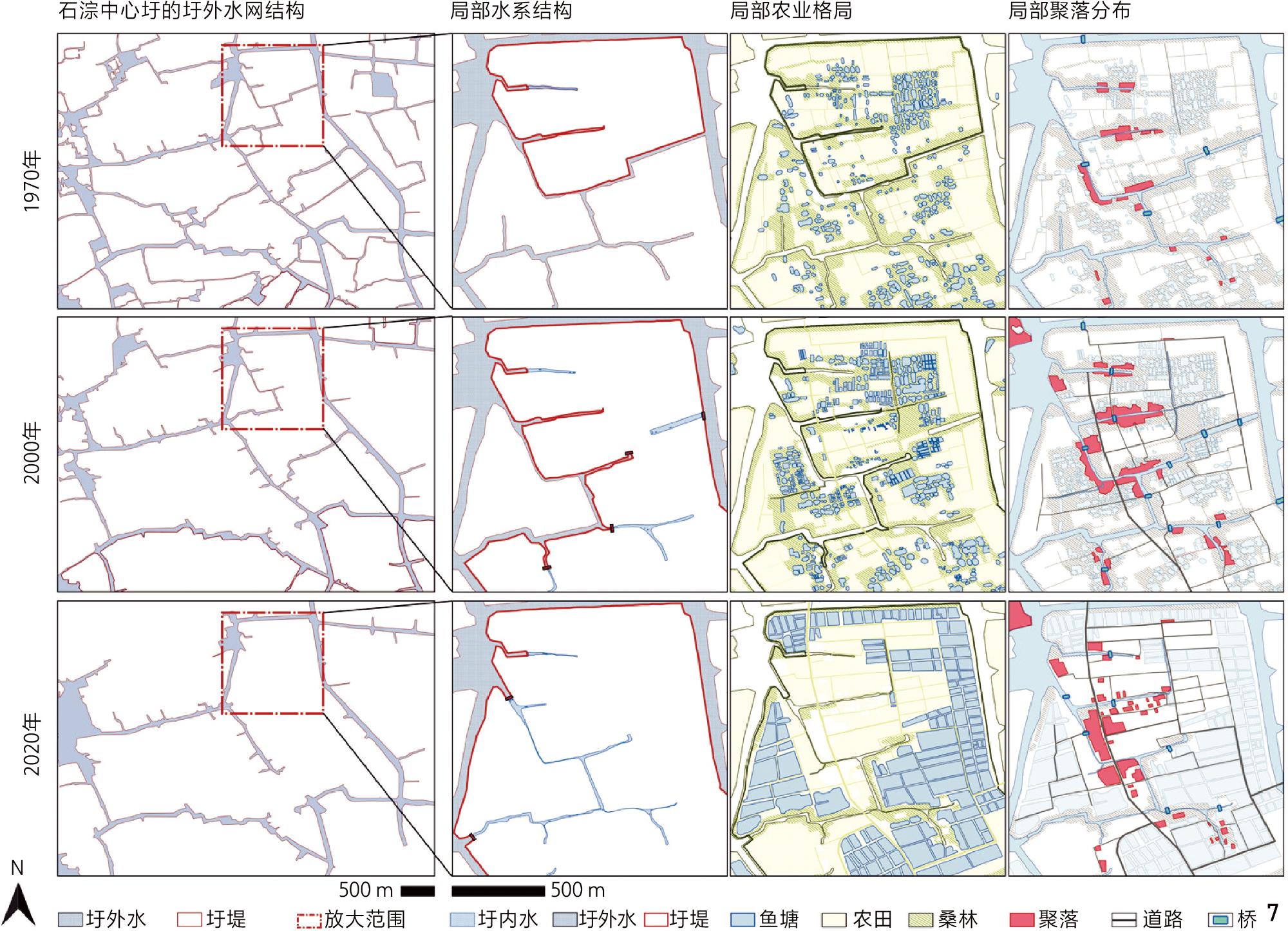
图7 田塘圩田典型案例石淙中心圩肌理演变Fig. 7 Texture evolution of Shicong Zhongxinwei, a typical case of dyke-pond polders |
表5 田塘圩田的演化特征Tab. 5 Evolutionary characteristics of the field-pond polder |
| 阶段(代表年份) | 圩田类型 | 水利景观特征 | 农业景观特征 | 聚落景观特征 |
|---|---|---|---|---|
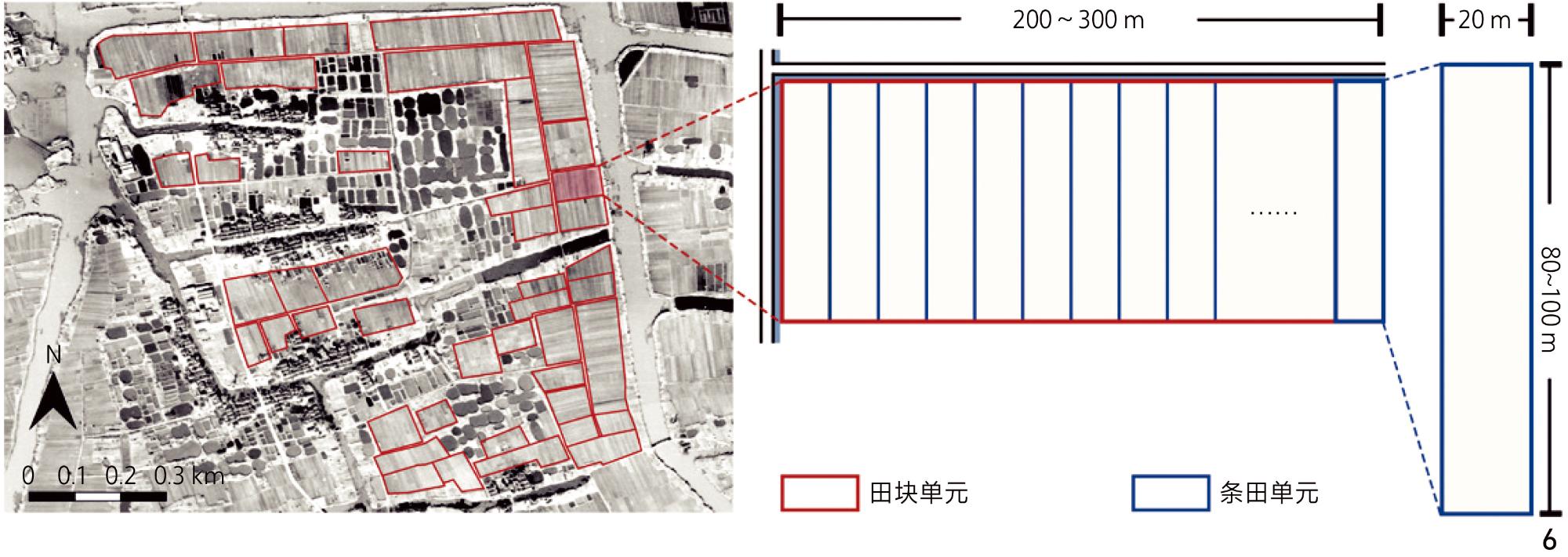
| 注:a)多级格网化农田,田块长约80~100 m,宽约14~20 m,面积0.1~0.2 hm2,数个田块依次排列形成200~300 m长的条田,数个条田组成一个土地单元,具体尺寸依水网而定。 | ||||
| 阶段一(1970) | 田塘圩田 | 圩内水网宽3~8 m | 圩田形态呈不规则多边形;鱼塘(平均0.09 hm2)呈椭圆形或近似矩形;田块面积为0.2~0.7 hm2不等;田塘比>4︰1 | 选址于圩田单元四周高堤或内河圩堤,呈条带状 |
| 阶段二(2000) | 早期标准型鱼塘;半规则田塘圩田 | 联圩并圩使圩堤长度减少;圩外水系保留并成为圩内骨干水网;部分小型水体转化为圩内鱼塘 | 鱼塘规模化扩张;近河道鱼塘(平均0.3 hm2)呈规则网格状;近聚落鱼塘 (平均0.07 hm2)近似矩形;农田呈多级格网化a) | 沿水系线性延伸,部分连接形成线状集村 |
| 阶段三(2020) | 网络型田塘圩田 | 联圩并圩进一步使圩内水网萎缩 | 鱼塘(平均0.78 hm2)呈网格化;农田合并为规则矩形大田块;田塘比大幅降低 | 聚落搬迁合并 |
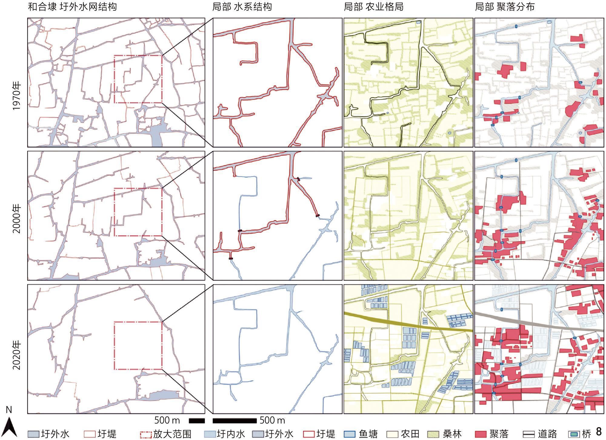
图8 桑基圩田典型案例和合埭肌理演变Fig. 8 Texture evolution of Hehedai, a typical case of mulberry-dyke polders |
表6 桑基圩田的演化特征Tab. 6 Evolutionary characteristics of the mulberry-dyke polder |
| 阶段(代表年份) | 圩田类型 | 水利景观特征 | 农业景观特征 | 聚落景观特征 |
|---|---|---|---|---|
| 阶段一(1970) | 桑基圩田 | 圩内水网宽3~8 m,形态较规则 | 圩田面积多>100 hm2,形态呈不规则多边形; 以宽10~90 m的桑林划分农田,田块呈方块状; 田林比大致为5︰4 | 选址于圩田单元四周高堤或内河圩堤,呈条带状 |
| 阶段二(2000) | 桑基圩田 | 联圩并圩使圩堤长度减少; 小型圩溇转换为农田; 部分骨干河道由自然变为规则 | 田内桑林减少,仅聚落及圩堤周边规模较大的桑林被保留; 农田多级格网化 | 沿水系路网扩张显著 |
| 阶段三(2020) | 破碎型圩田 | 除圩内圩外转换外,水利格局变化较少 | 近河道出现标准型鱼塘; 农田合并为矩形大田块(平均1.33 hm2); 桑林进一步衰退,不再限制农田肌理 | 进一步扩张切割农田; 部分搬迁向城镇集中 |
1、面向新中国成立后浙江湖州基塘圩田景观的土地整理过程,构建多尺度研究框架。在区域尺度通过景观演变评估模型量化水田村格局变化与土地整理程度。在单元尺度通过景观要素形态Mapping来解析3类圩田形态类型的差异化演变规律。
2、揭示圩田景观土地整理进程中,影响形态演变的制约-驱动机制,阐明政策与技术的驱动作用以及水利要素及自然环境的制约作用,为圩田景观的保护与发展提供参考。
| [1] |
湖州市江河水利志编纂委员会.湖州市水利志[M].北京: 中国大百科全书出版社, 1995.
Huzhou Rivers and Water Conservancy Annals Compilation Committee. Chronicles of Huzhou Water Conservancy[M]. Beijing: Encyclopedia of China Publishing House, 1995.
|
| [2] |
谢雨婷, 应佳欣, 陈琳. 长江三角洲圩田景观的类型、形态生成与适应性转型[J]. 城市发展研究, 2022, 29(4): 70-77.
XIE Y T, YING J X, CHEN L. Typology, Morphogenesis and Adaptive Transformation of Polder Landscape in the Yangtze River Delta[J]. Urban Development Studies, 2022, 29(4): 70-77.
|
| [3] |
郭巍, 侯晓蕾. 筑塘、围垦和定居: 萧绍圩区圩田景观分析[J]. 中国园林, 2016, 32(7): 41-48.
GUO W, HOU X L. Dyke, Reclamation and Settlement: Landscape Architectural Analysis of Polder Landscape in Xiaoshao Region[J]. Chinese Landscape Architecture, 2016, 32(7): 41-48.
|
| [4] |
孙瑾璐, 王晴, 郭巍. 西苕溪流域(土斗)-圩田传统人居体系成因及特征[J]. 风景园林, 2024, 31(1): 64-70.
SUN J L, WANG Q, GUO W. Origin and Characteristics of the Traditional Dike-Polder Human Settlement System of Xitiaoxi Watershed[J]. Landscape Architecture, 2024, 31(1): 64-70.
|
| [5] |
郭巍, 侯晓蕾, 崔子淇. 圩田景观视野下的宁波日月二湖传统风景营建研究[J]. 风景园林, 2021(5): 120-125.
GUO W, HOU X L, CUI Z Q. Research on Traditional Landscape Construction of Ningbo Sun Lake and Moon Lake Under the Perspective of Polder Landscape[J]. Landscape Architecture, 2021(5): 120-125.
|
| [6] |
都铭, 陈贇. 圩田传统影响下宋代西湖的风景营建[J]. 园林, 2024, 41(2): 38-44.
DU M, CHEN Y. The Landscape Construction of West Lake in the Song Dynasty Under the Influence of the Tradition of Weitian[J]. Landscape Architecture Academic Journal, 2024, 41(2): 38-44.
|
| [7] |
邱明, 戴代新. 景观再生视野下江淮传统圩田生态智慧的继承与发展[J]. 中国园林, 2019, 35(6): 94-98.
QIU M, DAI D X. Inheritance and Development of Traditional Ecowisdom of Polder Landscape in Yangtze River Region Based on Landscape Regeneration[J]. Chinese Landscape Architecture, 2019, 35(6): 94-98.
|
| [8] |
王建革. 水文、稻作、景观与江南生态文明的历史经验[J]. 思想战线, 2017, 43(1): 156-164.
WANG J G. Water Conservancy, Rice Cultivation and Landscape: Historical Experience of Ecological Civilization South of the Yangtze River[J]. Thinking, 2017, 43(1): 156-164.
|
| [9] |
CASTRO COELHO J, AGUIAR PINTO P, MIRA DA SILVA L. A Systems Approach for the Estimation of the Effects of Land Consolidation Projects (LCPs): A Model and Its Application[J]. Agricultural Systems, 2001, 68(3): 179-195.
|
| [10] |
MIRANDA D, CRECENTE R, ALVAREZ M F. Land Consolidation in Inland Rural Galicia, N.W. Spain, Since 1950: An Example of the Formulation and Use of Questions, Criteria and Indicators for Evaluation of Rural Development Policies[J]. Land Use Policy, 2006, 23(4): 511-520.
|
| [11] |
SUN P, GE D Z, YUAN Z Y, et al. Rural Revitalization Mechanism Based on Spatial Governance in China: A Perspective on Development Rights[J]. Habitat International, 2024, 147: 103068.
|
| [12] |
GUO W H, MA J, SONG X J, et al. Land Consolidation of Dryland-to-Paddy Conversion in China: Analysis of Spatial Patterns, Impacts on Cropland Ecosystem Services, and Adaptive Management Strategies[J]. Environmental Impact Assessment Review, 2024, 108: 107594.
|
| [13] |
ZHONG L N, WANG J, ZHANG X, et al. Effects of Agricultural Land Consolidation on Ecosystem Services: Trade-Offs and Synergies[J]. Journal of Cleaner Production, 2020, 264: 121412.
|
| [14] |
ZHANG Z F, ZHAO W, GU X K. Changes Resulting from a Land Consolidation Project (LCP) and Its Resource−Environment Effects: A Case Study in Tianmen City of Hubei Province, China[J]. Land Use Policy, 2014, 40: 74-82.
|
| [15] |
张琳, 苗晏凯, 黄松. 江南运河流域吴江段农业景观演变特征及驱动机制[J]. 风景园林, 2024, 31(12): 49-56.
ZHANG L, MIAO Y K, HUANG S. Characteristics and Driving Mechanisms of Agricultural Landscape Evolution in Wujiang Section of Jiangnan Canal Basin[J]. Landscape Architecture, 2024, 31(12): 49-56.
|
| [16] |
马湘泳.太湖地区乡村地理[M].北京: 科学出版社, 1990.
MA X Y. Rural Geography in Taihu Lake Area[M]. Beijing: Science Press, 1990.
|
| [17] |
陈慕婷, 周剑云, 鲍梓婷, 等. 省域湿地退化风险评价研究: 基于地理格网与景观特征单元的多尺度分析[J]. 中国园林, 2023, 39(4): 52-58.
CHEN M T, ZHOU J Y, BAO Z T, et al. Study on Risk Assessment of Provincial Wetland Degradation: Based on Multi-scale Analysis of Geographical Grids and Landscape Character Units[J]. Chinese Landscape Architecture, 2023, 39(4): 52-58.
|
| [18] |
陆鼎言, 王旭强.湖州入湖溇港和塘浦(溇港)圩田系统的研究[C]//湖州市水利学会.湖州入湖溇港和塘浦(溇港)圩田系统的研究研究成果资料汇编.湖州: 湖州市水利学会, 2005: 4-43.
LU D Y, WANG X Q. Research on the Huzhou Inflow Lougang Water Network and the Tangpu (Lougang) Polder System[C]//Huzhou Water Conservancy Society. Compilation of Research Results on the Huzhou Inflow Lougang Water Network and the Tangpu (Lougang) Polder System. Huzhou: Huzhou Water Conservancy Society, 2005: 4-43.
|
| [19] |
浙江省水利厅.浙江省杭嘉湖圩区整治“十三五”规划[EB/OL].[2025-03-20].https://www.docin.com/p-2178972143.html.
Department of Water Resources of Zhejiang Province. Zhejiang Province Hangzhou-Jiaxing-Huzhou Floodplain Management 13th Five-Year Plan[EB/OL]. [2025-03-20]. https://www.docin.com/p-2178972143.html.
|
| [20] |
YANG J, HUANG X. The 30 m Annual Land Cover Dataset and Its Dynamics in China from 1990 to 2019[DS/OL]. EARTH SYST SCI DATA[2025-03-20]. https://doi.org/10.5281/zenodo.8176941.
|
| [21] |
鲍梓婷, 蒋定哲, 周剑云, 等. 基于景观特征评估划定国土尺度景观规划管理的空间单元[J]. 中国园林, 2023, 39(3): 46-52.
BAO Z T, JIANG D Z, ZHOU J Y, et al. Delineation of Spatial Units for Landscape Planning and Management Based on Landscape Character Assessment (LCA) on Territorial Scale[J]. Chinese Landscape Architecture, 2023, 39(3): 46-52.
|
| [22] |
王红军, 余勇, 孙启祥. 水利影响下的江南圩田地景格局变迁: 以太湖中下游地区为例[J]. 建筑史学刊, 2023(2): 58-67.
WANG H J, YU Y, SUN Q X. Changes of the Polder Landscape Pattern in the Lower Yangtze Region Under the Influence of Irrigation Works: A Case Study of the Middle and Lower Reaches of Taihu Lake[J]. Journal of Architectural History, 2023(2): 58-67.
|
| [23] |
江苏省革命委员会水利局.圩区的规划和治理[M].北京: 水利电力出版社, 1978.
Jiangsu Provincial Revolutionary Committee Bureau of Water Conservancy. Planning and Management of Polder Areas[M]. Beijing: Water Conservancy and Electric Power Press, 1978.
|
| [24] |
《苕溪运河志》编纂委员会.苕溪运河志[M].北京: 中国水利水电出版社, 2010.
Compilation Committee of Chronicle of Tiaoxi Canal. Chronicle of Tiaoxi Canal[M]. Beijing: China Water Resources and Hydropower Press, 2010.
|
| [25] |
湖州市地名办公室.浙江省湖州市地名志[M].湖州: 湖州市地名领导小组, 1982.
Huzhou City Geographical Names Office. Toponymic Chronicle of Huzhou City, Zhejiang Province[M]. Huzhou: Huzhou City Geographical Names Leadership Group, 1982.
|
| [26] |
张健, 窦永群, 桂仲争, 等. 南方蚕区蚕桑产业循环经济的典型模式: 桑基鱼塘[J]. 蚕业科学, 2010, 36(3): 470-474.
ZHANG J, DOU Y Q, GUI Z Z, et al. Mulberry−Base−Fishpond, the Typical Model of Sericultural Circular Economy in Southern China[J]. Acta Sericologica Sinica, 2010, 36(3): 470-474.
|
| [27] |
杨晓, 焦雯珺, 闵庆文, 等.土地利用变化对农业文化遗产系统结构的影响: 以浙江省德清县为例[J].农业资源与环境学报, 2022, 39(5): 885-893.
YANG X, JIAO W J, MIN Q W, et al. The Impact of Land Use Change on the Structure of Agricultural Cultural Heritage System: A Case Study of Deqing County, Zhejiang Province[J]. Journal of Agricultural Resources and Environment, 2022, 39(5): 885-893.
|
| [28] |
李惠民, 姚志卫.菱湖镇志[M].北京: 昆仑出版社, 2009.
LI H M, YAO Z W. Chronicle of Linghu Town[M]. Beijing: Kunlun Publishing House, 2009.
|
| [29] |
Food and Agriculture Organization of the United Nations. Globally Important Agricultural Heritage Systems: Zhejiang Huzhou Mulberry-Dyke & Fish-Pond System, China[EB/OL]. (2021-05-20) [2025-07-28]. https://www.fao.org/giahs/giahs-around-the-world/china-zhejiang-huzhou-system/en.
|
| [30] |
LI H B, YUAN Y, ZHANG X L, et al. Evolution and Transformation Mechanism of the Spatial Structure of Rural Settlements from the Perspective of Long-Term Economic and Social Change: A Case Study of the Sunan Region, China[J]. Journal of Rural Studies, 2022, 93: 234-243.
|
| [31] |
国土资源部.关于土地开发整理工作有关问题的通知[EB/OL].(2004-12-27)[2025-03-20]. https://g.mnr.gov.cn/201701/t20170123_1427720.html.
Ministry of Land and Resources Notice on Issues Concerning Land Development and Consolidation[EB/OL]. (2004-12-27) [2025-03-20]. https://g.mnr.gov.cn/201701/t20170123_1427720.html.
|
| [32] |
郭巍, 侯晓蕾. 从土地整理到综合规划 荷兰乡村景观整治规划及其启示[J]. 风景园林, 2016, 23(9): 115-120.
GUO W, HOU X L. From Land Consolidation to Comprehensive Planning Summary and Implications of the Evolution of Rural Landscape Renovation in the Netherlands[J]. Landscape Architecture, 2016, 23(9): 115-120.
|
| [33] |
马蕊, 高一菲, 杜爽, 等. 基于田园空间博物馆理念的桑基鱼塘农业文化遗产保护研究: 以浙江省湖州市荻港村为例[J]. 景观设计学(中英文), 2023, 11(6): 22-43.
MA R, GAO Y F, DU S, et al. Research on Mulberry-Dyke & Fish-Pond Agricultural Heritage Protection Based on the Concept of Rural Environmental Museum: Case Study on Digang Village in Huzhou City, Zhejiang Province[J]. Landscape Architecture Frontiers, 2023, 11(6): 22-43.
|
/
| 〈 |
|
〉 |