
Assessment Method for Urban Green Space Shading Based on the Allometric Parametric Model
|
CHEN Yujie is a master graduate in the College of Horticulture & Forestry Sciences of Huazhong Agricultural University. Her research focuses on planning and design of urban green infrastructure |
|
ZHOU Zixuan is a master student in the College of Horticulture & Forestry Sciences of Huazhong Agricultural University. Her research focuses on planning and design of urban green infrastructure |
|
FENG Xiaoxia is a master student in the College of Horticulture & Forestry Sciences of Huazhong Agricultural University. Her research focuses on planning and design of urban green infrastructure |
|
ZHANG Wei, Ph.D., is an associate professor in the College of Horticulture & Forestry Sciences of Huazhong Agricultural University, and a member of the Key Laboratory of Urban Agriculture in Central China, Ministry of Agriculture and Rural Affairs. His research focuses on planning and design of urban green infrastructure |
Received date: 2025-01-07
Revised date: 2025-09-22
Online published: 2026-03-12
Copyright
In the context of accelerating urbanization and the escalating impacts of global warming, urban green spaces have become increasingly crucial for mitigating urban heat, as they offer shaded environments that significantly enhance the overall livability and comfort of urban environments. Consequently, the optimization of vegetation layout within urban green spaces has become a fundamental strategy for addressing climate change and improving the sustainable quality of life for urban residents. Currently, the assessment of green space shading in relevant norms at home and abroad is usually calculated based on the projected area of adult tree crowns. The result is a static indicator that cannot accurately reflect the three-dimensional morphological characteristics of the tree crown and the influence of the plant growth process on the shading effect. To accurately assess the shading area of green space, it is necessary to establish a dynamic assessment method for green space shading based on the three-dimensional growth model of plants and the real lighting environment. Such a method should reflect the three-dimensional elements of plant morphology and the dynamic nature of plant growth.
Based on the allometric growth equations for different tree species and plant crown morphology models, parametric tree growth models and a shading area generation algorithm for the shading area of green space trees are established in the Python and Grasshopper environment. The area within the 4-hour isohel on the summer solstice for trees in a green space is defined as the shading area of the green space and used as an assessment indicator for the shading effect of the green space, which is typically calculated by the calculation method for the shading area of a building as specified in the Assessment Standard for Green Building (GB/T 50378−2019). Additionally, taking Xiangyang Academy in Xiangyang City, Hubei Province, as an example, this research compares and explores the application characteristics of the shading algorithm, and generates a three-dimensional model for tree growth in and dynamic shading area of the selected site based on the aforesaid parametric generation algorithm to evaluate and analyze the shading range of the buildings and plants on the site.
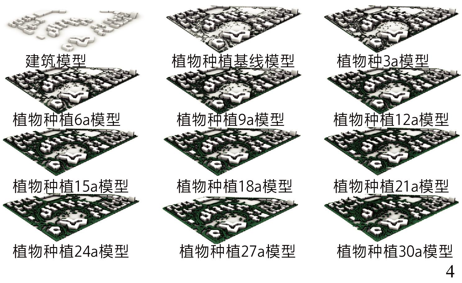
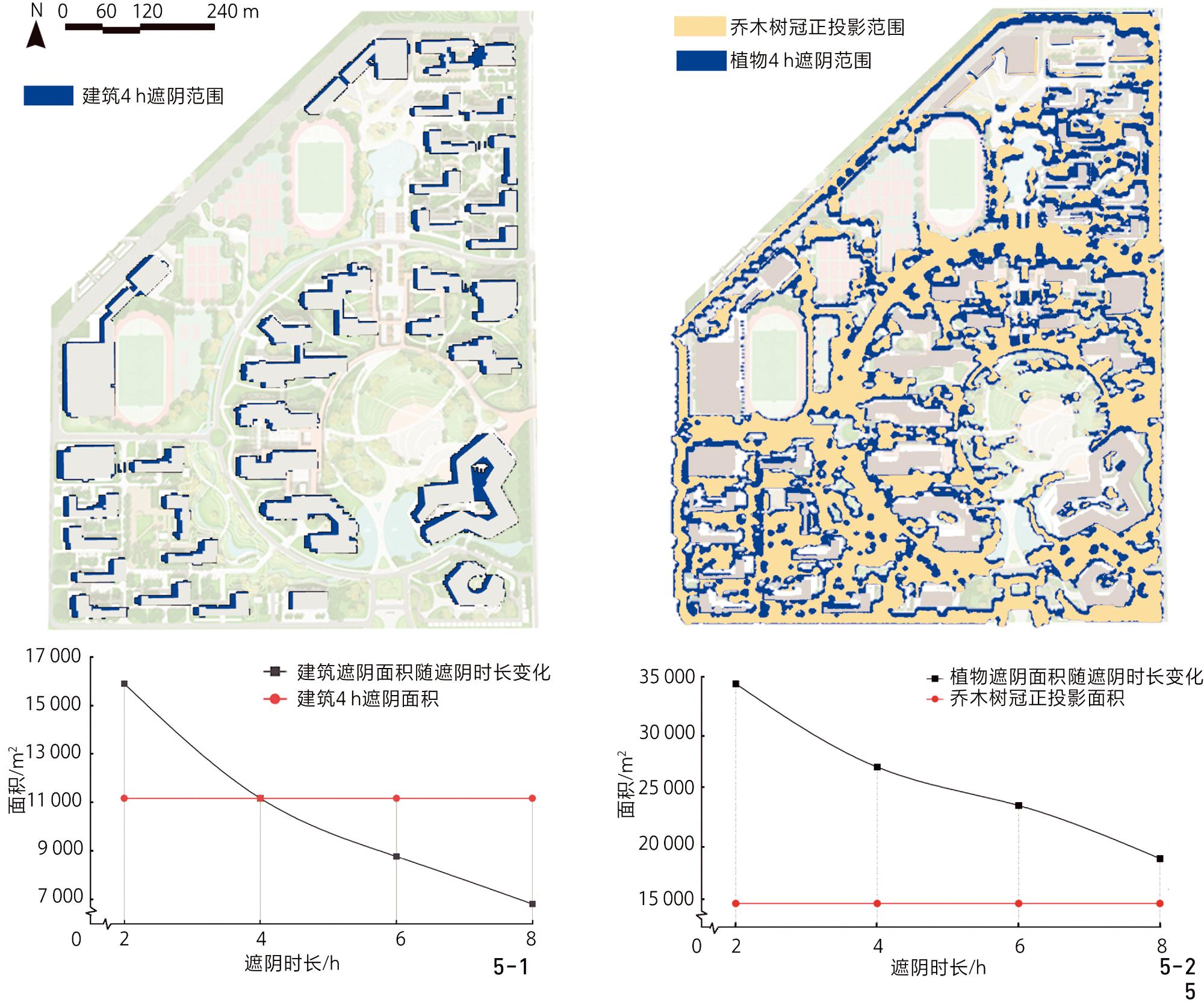
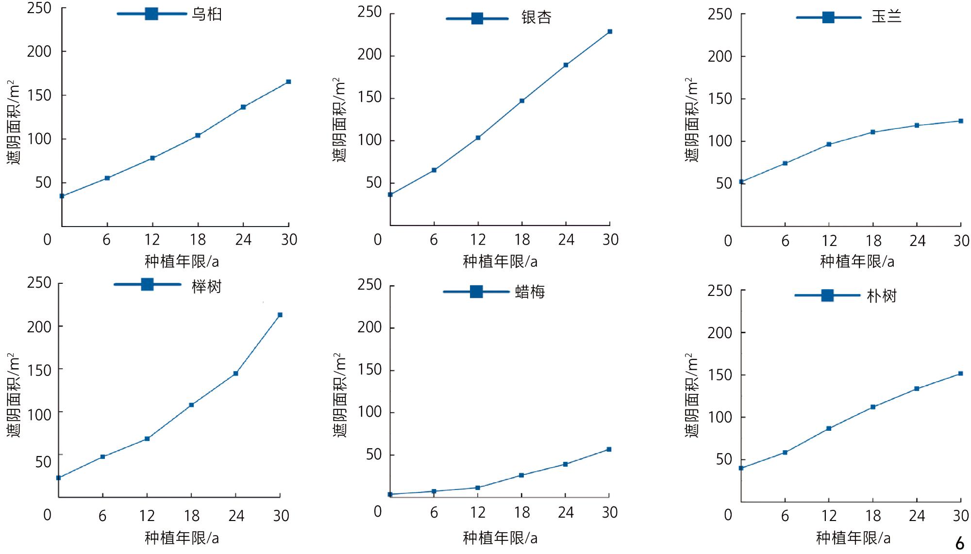
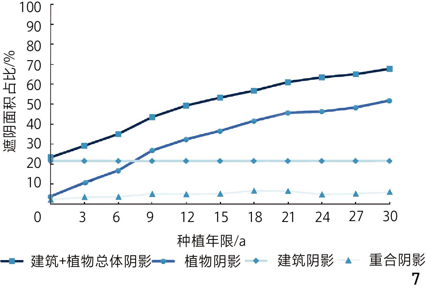
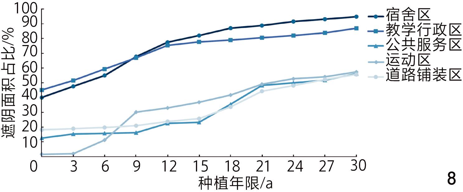
Compared with the calculation method based on the vertical projection of the tree crown, the shading simulation and assessment method based on the generated three-dimensional model for the site has the following characteristics. 1) It can dynamically simulate the actual light changes. The shadow area of green spaces within the campus of Xiangyang Academy is closer to the real shading situation. For example, after the trees have grown for thirty years, the overall shadow area of the campus accounts for 67.61% of the total area of the campus’s open space, among which the shadow area of buildings accounts for 21.55%, the shading area of green spaces accounts for 51.92%, and the overlapping area accounts for 5.86%. The calculation result of the vertical projection area of the tree canopy is 45.48% less than the area of the tree canopy, and there is a certain offset distance in space. 2) This observation reflects the temporal changes in vegetation shading on the site; the area of green space shading increases from 69,106 m2 to 269,086 m2 as plants grow, and the ratio of open space area rises from 13.33% to 51.92%, indicating a trend of rapid increase followed by gradual stabilization. 3) It can reflect the difference in shading ability of different tree species in different growth periods. Fast-growing tree species such as Celtis sinensis Pers. and Magnolia denudata Desr. have obvious shading effects in the early stage while slow-growing large trees such as Cinnamomum camphora (L.) and Zelkova serrata (Thunb.) Makino have better shading effects in the later stage. 4) It can reflect the differences in the shading characteristics of different areas, such as the campus dormitory area and teaching area with high greening and building density; the superimposed effect of plants and building shading is obvious, while the shading range of the athletic area is subject to significant changes in the growth of plants, and the plants planted have better shading potential and growth trend. Campus roads are mainly planted with slow-growing trees on both sides, with the shading area improving slowly; the overall trend is stable.
The shading algorithm based on the parametric growth model proposed in this research can generate more accurate dynamic shading range, reflecting the dynamic change of shading range during plant growth, and is consistent with the existing standards for building shading assessment. The algorithm can be used to predict and simulate the long-term shading effect in different periods, to quantify the shading capacity of multiple trees in different periods, and to evaluate the zoning in different scales of space. The research improves the accuracy and applicability of the assessment of shading areas in urban green spaces and combines parametric algorithms to build a reusable and automatic calculation process, which can be used as a reference for urban green space planning and climate-adaptive design.
CHEN Yujie , ZHOU Zixuan , FENG Xiaoxia , ZHANG Wei . Assessment Method for Urban Green Space Shading Based on the Allometric Parametric Model[J]. Landscape Architecture, 2026 , 33(1) : 109 -116 . DOI: 10.3724/j.fjyl.LA20250015
表1 现行绿色建筑和环境评估标准中与遮阴相关的部分条目[3-6]Tab. 1 Selected shading-related entries in existing green building and environmental assessment standards[3-6] |
| 标准名称 | 发布机构 | 相关内容 |
|---|---|---|
| 《建筑研究院环境评估方法可持续建筑认证标准》 | 英国建筑研究院(BRE Group) | 确保通过使用设计工具达到适当的热舒适度,需要使用符合CIBSE AM11建筑能源和环境建模的软件进行热环境建模[3] |
| 《能源与环境设计先锋认证标准》 | 美国绿色建筑委员会(U.S. Green Building Council) | 对于非屋顶措施的遮阴计算,植物以种植10 a的冠层垂直投影面积进行计算[4] |
| 《健康建筑标准》 | 国际健康建筑研究所(International WELL Building Institute) | 以遮蔽时间每日超过日照小时数的一半的范围作为有效遮阴面积[5] |
| GB/T 50378-2019《绿色建筑评价标准》 | 中国住房和城乡建设部 | 建筑阴影区为夏至日8:00—16:00时段在4 h日照等时线内的区域;乔木遮阴面积按照成年乔木的树冠正投影面积计算;构筑物遮阴面积按照构筑物正投影面积计算[6] |
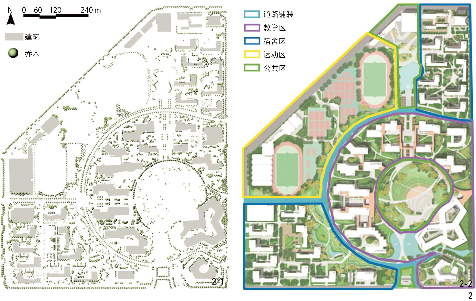
图2 襄阳书院已建成主校区乔木和建筑分布(2-1)及分区(2-2)情况Fig. 2 Distribution of trees and buildings (2-1) within and zoning (2-2) of the built-up campus area of Xiangyang Academy |
表2 襄阳书院已建成主校区不同分区绿地指标概况Tab. 2 Overview of green space indicators in different zones of the built-up campus area of Xiangyang Academy |
| 分区 | 面积/m2 | 绿地面积/ m2 | 乔木数量/株 | 乔木正投影面积/m2 | 乔木正投影面积比率/% |
|---|---|---|---|---|---|
| 注:道路铺装区域种植树木的树池暂未纳入绿地面积考虑,因此该区域未统计绿地面积。 | |||||
| 宿舍区 | 118 786.84 | 49 941.01 | 2 010 | 49 349.38 | 41.46 |
| 教学行政区 | 151 294.52 | 56 232.20 | 1 979 | 45 330.95 | 29.96 |
| 公共服务区 | 74 158.09 | 30 100.80 | 337 | 18 164.32 | 24.49 |
| 运动区 | 108 538.51 | 28 779.80 | 641 | 23 765.69 | 21.90 |
| 道路铺装区 | 65 514.44 | 451 | 10 090.92 | 15.40 | |
| 总计 | 518 292.40 | 165 053.10 | 5 397 | 146 701.26 | 28.30 |
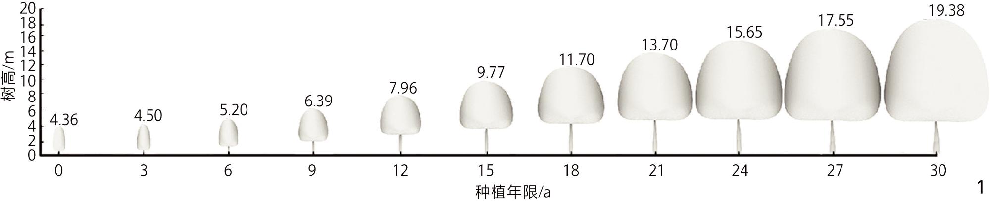
表3 襄阳书院已建成主校区树种的异速生长方程示例Tab. 3 Allometric growth equations example for tree species in the built-up campus area of Xiangyang Academy |
| 树种 | 变量 | 计算式 |
|---|---|---|
| 栾树 | 树龄(a) | |
| 胸径(y) | | |
| 树高(h) | | |
| 冠幅(g) | | |
| 冠高(l) | l |
表4 乔木种植30 a后校园不同活动区域的遮阴效果比较(基于4 h等时线)Tab. 4 Comparison of shading effects of trees in different activity areas of the campus after 30 years of planting (based on the 4-hour isohel) |
| 分区 | 综合遮阴面积占比/% | 建筑遮阴面积占比/% | 植物遮阴面积占比/% |
|---|---|---|---|
| 注:由于场地内建筑分布距离道路铺装区较远,建筑产生的遮阴极少投射到道路铺装区,因此占比忽略不计。 | |||
| 宿舍区 | 90.96 | 25.19 | 84.36 |
| 教学行政区 | 86.99 | 35.74 | 60.65 |
| 公共服务区 | 56.21 | 15.38 | 43.06 |
| 运动区 | 57.44 | 12.40 | 47.11 |
| 道路铺装区 | 55.72 | 0 | 55.72 |
文中图表均由作者绘制。
1、基于植物生长方程和参数化建模进行植物的三维动态遮阴效果模拟,代替传统二维静态投影的遮阴计算方法,提高绿地遮阴评估的准确性。
2、参考中国GB/T50378—2019《绿色建筑评价标准》中的建筑阴影评估方法,提出基于4 h日照等时线的植物遮阴面积作为评估植物遮阴效果的量化标准,以构建统一的遮阴评估方法。
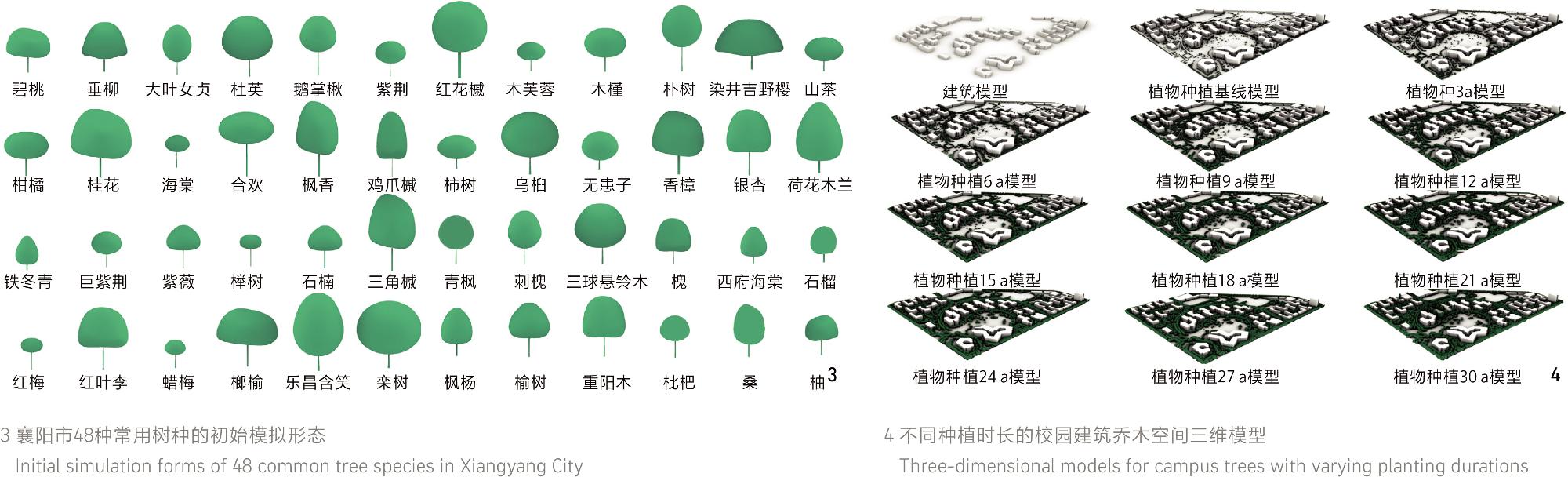
3、基于湖北省襄阳市48种常用园林植物类型,构建了可推广使用的遮阴面积参数化生成算法,有效支撑了绿地遮阴评估体系的构建与优化。
| [1] |
CAO J, ZHOU W Q, WANG J, et al. Significant Increase in Extreme Heat Events Along an Urban−Rural Gradient[J]. Landscape and Urban Planning, 2021, 215: 104210.
|
| [2] |
MILLER S M, MONTALTO F A. Stakeholder Perceptions of the Ecosystem Services Provided by Green Infrastructure in New York City[J]. Ecosystem Services, 2019, 37: 100928.
|
| [3] |
MAO J, YUAN H, XIONG L, et al. Research Review of Green Building Rating System Under the Background of Carbon Peak and Carbon Neutrality[J]. Buildings, 2024, 14(5): 1257.
|
| [4] |
PHAM D H, LEE J, AHN Y. Implementing LEED V4 BD+C Projects in Vietnam: Contributions and Challenges for General Contractor[J]. Sustainability, 2019, 11(19): 5449.
|
| [5] |
袁梦, 张群, 成辉, 等. 美国WELL建筑标准评价框架与指标内容演变[J]. 建筑科学, 2019, 35(12): 144-151.
YUAN M, ZHANG Q, CHENG H, et al. Evolution of Evaluation Framework and Index Contents of the WELL Building Standard[J]. Building Science, 2019, 35(12): 144-151.
|
| [6] |
王清勤, 李国柱, 姜波, 等. 国家标准GB/T 50378—2019(2024年版)《绿色建筑评价标准》介绍[J]. 建筑科学, 2024, 40(10): 149-152,178.
WANG Q Q, LI G Z, JIANG B, et al. An Introduction of GB/T 50378−2019 (2024 Version) Assessment Standard for Green Building[J]. Building Science, 2024, 40(10): 149-152,178.
|
| [7] |
LIU C C, ZHU H H, LI L, et al. Spatiotemporal Expression and Application of Urban Residential Solar Rights Based on CityGML-LADM[J]. International Journal of Digital Earth, 2023, 16(1): 2301-2321.
|
| [8] |
DIAMBU S M, OSOMBA D W, MAYENA T K, et al. Contribution of ALOS PALSAR DEM Imagery to the Study of Geological and Morphostructural Lineaments of Boma Trough Block, Onshore Coastal Basin of D.R. Congo[J]. Indonesian Journal of Earth Sciences, 2023, 3(1): A632.
|
| [9] |
赵从博.基于绿建标准的既有居住区室外环境分析和改造[D].沈阳: 沈阳大学, 2020.
ZHAO C B. Analysis and Renovation of Outdoor Environment of Existing Residential Area Based on Green Building Standard[D]. Shenyang: Shenyang University, 2020.
|
| [10] |
于红霞, 商钰淇, 商彤. 基于里院光环境的节能改造[J]. 大连工业大学学报, 2018, 37(4): 309-312.
YU H X, SHANG Y Q, SHANG T. Green Energy-Saving Lighting Renovation Based on Light Environment in Liyuan[J]. Journal of Dalian Polytechnic University, 2018, 37(4): 309-312.
|
| [11] |
MAKSOUD A, ALI HUSSIEN A, TATAN L, et al. Simulation-Driven and Optimization-Based Design of an Architectural Building: A Case Study of a Space Tourism Building in the UAE[J]. Buildings, 2023, 13(12): 2927.
|
| [12] |
张泽, 吴正旺. 日照时长导向的高层住区形态多目标优化研究[C]//中国建筑学会. 2022—2023中国建筑学会年会论文集. 北京: 中国建筑工业出版社, 2023: 311-318.
ZHANG Z, WU Z W. A Multi-objective Optimization Study of Sunshine Duration Oriented High-Rise Settlement Form[C]//Architectural Society of China. Proceedings of the Architectural Society of China 2022−2023. College of Architecture. Beijing: China Architecture & Building Press, 2023: 311-318.
|
| [13] |
黄秋燕, 杨建欣, 陈安, 等. 榕属4个园林树种遮荫效果研究[J]. 江苏林业科技, 2022, 49(4): 24-30.
HUANG Q Y, YANG J X, CHEN A, et al. Shading Effect of Four Landscape Ficus sp Trees in Moraceae[J]. Journal of Jiangsu Forestry Science & Technology, 2022, 49(4): 24-30.
|
| [14] |
YU Q Y, JI W J, PU R L, et al. A Preliminary Exploration of the Cooling Effect of Tree Shade in Urban Landscapes[J]. International Journal of Applied Earth Observation and Geoinformation, 2020, 92: 102161.
|
| [15] |
苏宏霖, 唐丽玉, 陈季委, 等. 三维场景树荫模拟与量化: 以城市街道为例[J]. 地球信息科学学报, 2024, 26(11): 2493-2505.
SU H L, TANG L Y, CHEN J W, et al. Simulation and Quantification of Tree Shade in Three-Dimensional Scenes: A Case Study of Urban Street[J]. Journal of Geo-Information Science, 2024, 26(11): 2493-2505.
|
| [16] |
WANG Y P, AKBARI H. The Effects of Street Tree Planting on Urban Heat Island Mitigation in Montreal[J]. Sustainable Cities and Society, 2016, 27: 122-128.
|
| [17] |
马尔温, 杨俊宴, 郑屹, 等. 关联·机制·治理: 基于微气候评价的高密度城市步行适宜性环境营造研究[J]. 国际城市规划, 2019, 34(5): 16-26.
MARVIN S, YANG J Y, ZHENG Y, et al. Correlation, Mechanism, Control: Research on High-Density Urban Pedestrian Suitability Environment Construction Based on Micro-climate Assessment[J]. Urban Planning International, 2019, 34(5): 16-26.
|
| [18] |
吴凡.荒漠草本植物在不同营养条件下不同生长时期异速生长规律研究[D].兰州: 兰州大学, 2017.
WU F. Allometric Law of Desert Herbs Under Different Nutrition Status at Different Growth Stages[D]. Lanzhou: Lanzhou University, 2017.
|
| [19] |
LI Z Y, LUO Q H, XU Z L. Effects of Stand Density on the Biomass Allocation and Tree Height-Diameter Allometric Growth of Picea Schrenkiana Forest on the Northern Slope of the Western Tianshan Mountains[J]. Arid Zone Research, 2021, 38(2): 545-552.
|
| [20] |
OURIA M, SEVINC H. Evaluation of the Potential of Solar Energy Utilization in Famagusta, Cyprus[J]. Sustainable Cities and Society, 2018, 37: 189-202.
|
| [21] |
KONIS K, GAMAS A, KENSEK K. Passive Performance and Building Form: An Optimization Framework for Early-Stage Design Support[J]. Solar Energy, 2016, 125: 161-179.
|
| [22] |
WAQAS H, SHANG J G, MUNIR I, et al. Enhancement of the Energy Performance of an Existing Building Using a Parametric Approach[J]. Journal of Energy Engineering, 2023, 149: 04022057.
|
| [23] |
JIA D D, ZHENG W G, WEI X M, et al. Parametric Design and Genetic Algorithm Optimization of a Natural Light Stereoscopic Cultivation Frame[J]. Agriculture, 2024, 14(1): 84.
|
| [24] |
LIU D L, WANG K Q. Research on the Siting of Rural Public Cultural Space Based on the Path-Clustering Algorithm: A Case Study of Yumin Township, Yushu City, Jilin Province, China[J]. Sustainability, 2023, 15(3): 1999.
|
| [25] |
DUTTA G S, MEINERS D, MERKERT N. A Study of Free-Form Shape Rationalization Using Biomimicry as Inspiration[J]. Polymers, 2023, 15(11): 2466.
|
| [26] |
张亚敏. 山水森林城 宜居新襄阳[J]. 国土绿化, 2019(9): 34-39.
ZHANG Y M. Landscape Forest City, Livable New Xiangyang[J]. Land Greening, 2019(9): 34-39.
|
| [27] |
吴家祺, 詹庆明, 巫溢涵, 等. 基于通风潜力的襄阳市通风廊道规划指引研究[C]//城市规划新技术应用学术委员会.智慧规划· 生态人居· 品质空间: 2019 年中国城市规划信息化年会论文集, 南宁: 广西科学技术出版社, 2019.
WU J Q, ZHAN Q M, WU Y H, et al. Research on Planning Guidance of Ventilation Corridors in Xiangyang Based on Ventilation Potential[C]//Academic Committee on New Technologies in Urban Planning. Smart Planning, Ecological Human Settlement, Quality Space: Proceedings of the 2019 China Urban Planning Informatization Annual Conference. Nanning: Guangxi Science & Technology Publishing House Co, Ltd., 2019.
|
| [28] |
王浴淇, 肖映辉, 詹庆明. 基于 CFD 的襄阳市卧龙大道片区适应性优化[C]//城市规划新技术应用学术委员会. 智慧规划·生态人居·品质空间: 2019 年中国城市规划信息化年会论文集, 南宁: 广西科学技术出版社, 2019.
WANG Y Q, XIAO Y H, ZHAN Q M. Adaptability Optimization of Wolong Avenue Area in Xiangyang City Based on CFD[C]//Academic Committee on New Technologies in Urban Planning. Smart Planning, Ecological Human Settlement, Quality Space: Proceedings of the 2019 China Urban Planning Informatization Annual Conference, Nanning: Guangxi Science & Technology Publishing House Co, Ltd., 2019.
|
| [29] |
孙迪, 章莉. 夏季襄阳唐城影视基地热舒适对游客场所感知影响及优化措施研究[J]. 园林, 2023, 40(8): 72-82.
SUN D, ZHANG L. Study on the Influence of Thermal Comfort on Tourists' Perception of Place and Its Optimization Measures in Xiangyang Tangcheng Film and Television Base in Summer[J]. Landscape Architecture Academic Journal, 2023, 40(8): 72-82.
|
| [30] |
SALAS-ELJATIB C, MEHTÄTALO L, GREGOIRE T G, et al. Growth Equations in Forest Research: Mathematical Basis and Model Similarities[J]. Current Forestry Reports, 2021, 7(4): 230-244.
|
| [31] |
周宏轩, 陶贵鑫, 炎欣烨, 等. 绿量的城市热环境效应研究现状与展望[J]. 应用生态学报, 2020, 31(8): 2804-2816.
ZHOU H X, TAO G X, YAN X Y, et al. A Review of Research on the Urban Thermal Environment Effects of Green Quantity[J]. Chinese Journal of Applied Ecology, 2020, 31(8): 2804-2816.
|
| [32] |
刘建峰.我国常见树种通用生物量相对生长方程建模研究[D].金华: 浙江师范大学, 2021.
LIU J F. Modeling Study of Generic Allometric Biomass Equations for Common Tree Species in China[D]. Jinhua: Zhejiang Normal University, 2021.
|
| [33] |
THIPPAWAN S, CHOWTIWUTTAKORN K, PONGPATTANANURAK N, et al. Allometric Models to Estimate the Biomass of Tree Seedlings from Dry Evergreen Forest in Thailand[J]. Forests, 2023, 14(4): 725.
|
| [34] |
MCPHERSON E G, VAN DOORN N S, PEPER P J. Urban Tree Database and Allometric Equations[R]. Albany, CA: U.S. Department of Agriculture, Forest Service, Pacific Southwest Research Station, 2016.
|
| [35] |
李文娇.基于植物参数化生长模型的绿地景观绩效指标提取和评估方法研究: 以武汉市戴家湖公园绿地为例[D].武汉: 华中农业大学, 2024.
LI W J. Research on the Extraction and Assessment Method of Greenland Landscape Performance Indicators Based on Plant Parameterized Growth Model[D]. Wuhan: Huazhong Agricultural University, 2024.
|
| [36] |
耿君, 田庆久, 涂丽丽, 等. 树冠尺寸对冠层间隙率和聚集度指数的影响[J]. 遥感学报, 2016, 20(6): 1319-1327.
GENG J, TIAN Q J, TU L L, et al. Influences of Crown Size on the Estimation of Gap Fraction and Clumping Index[J]. National Remote Sensing Bulletin, 2016, 20(6): 1319-1327.
|
| [37] |
LAUSCH A, ERASMI S, KING D J, et al. Understanding Forest Health with Remote Sensing-Part II: A Review of Approaches and Data Models[J]. Remote Sensing, 2017, 9(2): 129.
|
| [38] |
JUUSO L. Procedural Generation of Imaginative Trees Using a Space Colonization Algorithm[D]. Västerås: Mälardalen University, 2017.
|
| [39] |
陈逸, 曹骏, 陈鹭芸, 等. MATLAB环境下基于三维L系统的树木形态模拟[J]. 现代计算机, 2024, 30(13): 57-62.
CHEN Y, CAO J, CHEN L Y, et al. Simulation of Tree Morphology Based on 3D L-system in MATLAB Environment[J]. Modern Computer, 2024, 30(13): 57-62.
|
| [40] |
HIDAYAT E W, GIRIANTARI I A D, SUDARMA M, et al. Visualization of a Three-Dimensional Tree Modeling Using Fractal Based on L-system[C]//2020 IEEE International Conference on Sustainable Engineering and Creative Computing. Piscataway, NJ: IEEE, 2020: 418-422.
|
| [41] |
张炜, 郝佳雪. 基于L-system算法的植物信息模型构建和三维绿量分析[J]. 风景园林, 2023, 30(3): 96-104.
ZHANG W, HAO J X. Construction of Plant Information Model and Analysis of 3D Green Quantity Based on L-system Algorithm[J]. Landscape Architecture, 2023, 30(3): 96-104.
|
| [42] |
ZHANG C Y, ZHOU Y H, QIU F. Individual Tree Segmentation from LiDAR Point Clouds for Urban Forest Inventory[J]. Remote Sensing, 2015, 7(6): 7892-7913.
|
| [43] |
GUO Y L, WANG H Y, HU Q Y, et al. Deep Learning for 3D Point Clouds: A Survey[J]. IEEE Transactions on Pattern Analysis and Machine Intelligence, 2021, 43(12): 4338-4364.
|
| [44] |
LEE J J, LI B S, BENES B. Latent L-systems: Transformer-Based Tree Generator[J]. ACM Transactions on Graphics, 2023, 43(1): 1-16.
|
/
| 〈 |
|
〉 |