
Design Characteristics of Campus Pedestrian Spaces of Comprehensive Universities in Singapore
|
LIU Yanhan is Ph.D. candidate in the College of Design and Engineering, National University of Singapore. Her research focuses on urban public space, intergenerational interaction, and multigenerational community planning |
|
HE Zhuoshu is teaching assistant (educator track) in the College of Design and Engineering, National University of Singapore, and a guest researcher of spatial planning and strategy at Delft University of Technology. His research focuses on urban morphology, neighborhood social mix planning, and urban diversity |
|
ZHANG Ye, Ph.D., is tenured associate professor and doctoral supervisor in the School of Architecture, Tsinghua University, and adjunct associate professor in the College of Design and Engineering, National University of Singapore. His research focuses on urban design and theory, urban morphology, urban public space, and sharing cities |
Received date: 2025-06-05
Revised date: 2025-10-28
Online published: 2025-12-26
Copyright
[Objective] The quality of pedestrian environments is a crucial component of campus planning for comprehensive universities. As contemporary higher education increasingly emphasizes interdisciplinary communication, well-designed pedestrian environments can help foster interaction, strengthen campus identity, and promote active mobility. However, a great deal of research has identified the pedestrian-unfriendly conditions of university campuses in China, particularly those constructed in recent decades. Most empirical research has focus on sidewalks in campuses, while overlooking the characteristics and qualities of pedestrian spaces within squares, green spaces, and void spaces, revealing the limitations of quantitative evaluation. The lack of systematic characterization in existing studies also limits their applicability as practical guidances for campus pedestrian planning, in which urban design plays an integrative role. Therefore, a systematic spatial and design analysis of exemplary cases is needed. Singapore stands out for its well-developed pedestrian networks that effectively respond to tropical climatic conditions, support placemaking, and integrate with campus and urban systems. These qualities are particularly evident in its two comprehensive universities: the National University of Singapore (NUS) and Nanyang Technological University (NTU). This research examines the spatial and design characteristics of pedestrian spaces in NUS and NTU, aiming to extract strategies applicable to campus regeneration. The research first establishes a framework through a literature review that synthesizes key factors related to campus pedestrian environments and distinctive characteristics of Singapore’s pedestrian planning. Building on this framework, the research combines quantitative spatial analysis with qualitative mapping, on-site observation, and design analysis to identify the configurational and design characteristics of pedestrian spaces in the campuses of the both universities mentioned above. The findings further inform a discussion on design and management strategies for improving pedestrian environments in other universities.
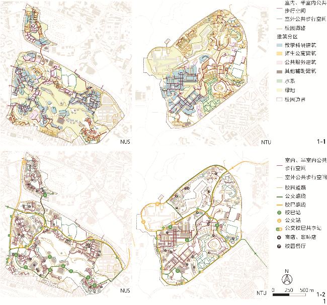
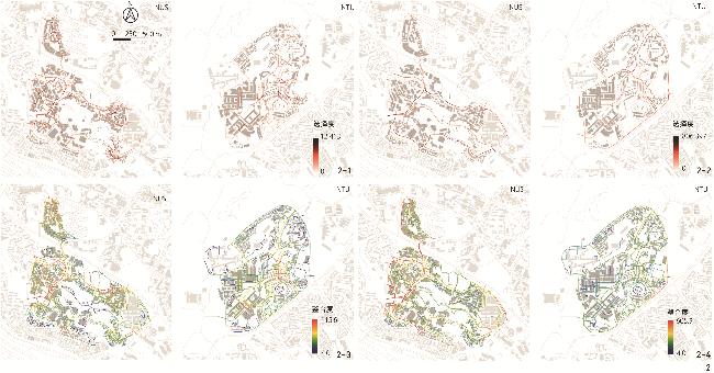
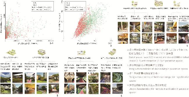
[Methods] This research employs a mixed-methods approach for analyzing the design characteristics of pedestrian spaces. First, the research establishes an analysis framework based on a literature review. The review summarizes key spatial factors related to pedestrian on the campus from the perspectives of international research and distinctive characteristics of Singapore’s pedestrian system. The framework comprises four dimensions: overall spatial layout, public space design and placemaking, landscape integration, and infrastructural application. Second, on-site observation, spatial analysis and design analysis are conducted to unpack the characteristics of the campuses of the both universities. Specifically, observation comprises photography, measurement, hand sketching and mapping. Design characteristics are summarized in an inductive approach, according to the four-dimensional framework. In particular, to analyze the overall spatial layout, comprehensive mapping and configurational analysis are conducted. Mapping overlays walking spaces with campus functional layout and transportation systems. Based on the space syntax theory, a configurational analysis is conducted to measure the spatial relationships between one pedestrian space to another. This research employs two classical parameters, integration and choice, to measure to-potential and through-potential of each pedestrian space in relating to other spaces at local (400 m radius) and district (2,000 m radius) scales.
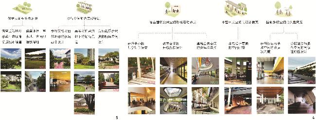
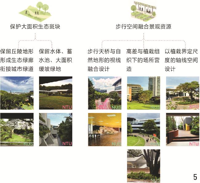
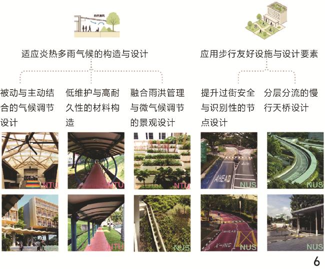
[Results] The analysis reveals that both NUS and NTU develop comprehensive pedestrian systems characterized by the above four aspects, overall layout, public space, landscape integration, and infrastructural application. First, continuous networks of covered walkways connect academic, residential, and service functions, as well as public transport nodes. The compact built form of the campuses of the both universities shortens pedestrian distance, promotes pedestrian activities, and makes pedestrian systems more efficient. Public transport routes are accessible to the campuses and share stops with campus shuttle, well-connected with covered walkways. Major covered walkways are laid out effectively to support local pedestrian activities, shown by high 400 m Choice values. While campus roads are supportive to the public transport for accessing to the campuses, shown by 2,000 m Choice. Besides, special attention should be paid to relations between multiple types of pedestrian spaces and campus roads and the configurational legibility of pedestrian spaces. Second, pedestrian spaces at NUS and NTU are characterized by their public space design and placemaking, which extend pedestrian nodes into multifunctional places that support studying, social interaction, and leisure. These node spaces are equipped with diverse forms of seats, lights, plants and equipment for better thermal comfort, encouraging encounter and stay. In particular, maintaining pedestrian spaces, both paths and nodes, at a human scale is crucial not only for users’ comfort while staying, but also for minimumizing impact on nature. Third, landscape integration balances aesthetic design with ecological and environmental performance. Shaded corridors, rain gardens, and terrain-responsive pathways enhance thermal comfort, support stormwater management, and strengthen ecological sustainability, while preserving the natural terrain and reinforcing campus identity. Fourth, infrastructure application comprises pedestrian-friendly elements and climate-responsive design. Natural ventilation, canopies, and semi-open transitions enhance microclimatic comfort, while durable materials, modular drainage systems, and traffic-calming measures improve accessibility, safety, and long-term maintainability. Despite these strengths, challenges persist, such as narrow pedestrian routes and limited connectivity with adjacent neighborhoods. Nevertheless, the two Singapore examples illustrate how progressive infill and adaptive design renewal can transform pedestrian systems into cohesive, efficient, and socially vibrant pedestrian environments.
[Conclusion] NUS and NTU demonstrate effective coverage of pedestrian spaces for core university functions with limited investment. Moreover, design strategies integrating pedestrian spaces with campus functions, public spaces, landscape resources, and transport systems can create walkable, vibrant, multi-functional and thermally comfortable pedestrian environments. Beyond spatial layout and design, the study offers more insights for universities subject to regeneration, particularly in China. First, despite different campus form, pedestrian space can be incrementally integrate with teaching and research spaces, amenities, and public transport. Second, creating vibrant pedestrian spaces and fostering placemaking of public space require accessible campus for pedestrian and open building public and transport spaces. A new Town & Gown relationship comprising accessible campus, shared facilities and open buildings means new management paradigms. Third, a compact building layout combined with human-scale public spaces forms the spatial foundation for active pedestrian space. This is achievable through the innovation of climate-response design elements, even under the current sunlight code of China. Fourth, digital analytical tools, such as behavioral tracking and environmental monitoring, can support participatory planning and performance evaluation. Successful campus pedestrian systems emerge from the coordination of spatial design, institutional management, and functional programming.
LIU Yanhan , HE Zhuoshu , ZHANG Ye . Design Characteristics of Campus Pedestrian Spaces of Comprehensive Universities in Singapore[J]. Landscape Architecture, 2025 , 32(12) : 96 -104 . DOI: 10.3724/j.fjyl.LA20250341
表1 新加坡国立大学和南洋理工大学校园概况Tab. 1 Outline of National University of Singapore and Nanyang Technological University campuses |
| 校园 | 新加坡国立大学肯特岗校区 | 南洋理工大学云南园校区 |
|---|---|---|
| 占地面积 | 约150 hm2 | 约200 hm2 |
| 学生人数 | 全校约29 800名本科生,13 900名研究生(其中约2 000名学生不在该校区) | 全校约24 800名本科生,12 700名研究生 |
| 功能布局 | 教学科研建筑按学部分为若干组团,生活、运动设施穿插其中 | 教学科研区相对集中,与生活、运动设施形成功能分区 |
| 建筑形态 | 自由式、阶梯布局 | 轴线式与环形布局结合 |
| 地形 | 丘陵 | 洼地、坡地 |
| 区位及周边用地 (容积率) | 位于中央规划区西部,周边为纬壹科技城(3~7)、新加坡科学城(2~3)、组屋社区(2.8~3.5)、小住宅和公寓(1~2)、学校、城市绿地 | 位于建成区边缘、毗邻西部集水区(自然保护区),周边为组屋社区(2.8)、裕廊工业园(1.4~2.5) |
1、界定了校园步行环境的4个关键方面——整体布局、公共空间营造、景观融合与设施构造,系统分析了新加坡2所综合性大学步行空间的组构与设计特征,为大学步行系统的设计与更新提供参照。
2、通过案例研究,阐明集约化布局下,通过各类步行空间与校园功能、交通系统紧密衔接,形成多样化的空间界面和形态,融合自然与景观要素,结合气候适应、步行友好设计要素,为校园的步行空间兼顾交通、活力与热舒适性的设计与更新提供参考。
| [1] |
LU Y, SARKAR C, YE Y, et al Using the Online Walking Journal to Explore the Relationship Between Campus Environment and Walking Behaviour[J]. Journal of Transport & Health, 2017, 5: 123.-132.
|
| [2] |
ZHANG Z H, SUN T Y, FISHER T, et al The Relationships Between the Campus Built Environment and Walking Activity[J]. Scientific Reports, 2024, 14: 20330.
|
| [3] |
PENN A, DESYLLAS J, VAUGHAN L The Space of Innovation: Interaction and Communication in the Work Environment[J]. Environment and Planning B: Planning and Design, 1999, 26 (2): 193.-218.
|
| [4] |
刘畅, 梅洪元 寒地大学校园步行环境的优化设计策略研究[J]. 建筑学报, 2019 S1 123.-128.
LIU C, MEI H Y Optimal Design Strategy for Walking Environment of University Campus in Cold Region[J]. Architectural Journal, 2019 S1 123.-128.
|
| [5] |
刘铮, 王世福, 莫浙娟 校城一体理念下新城式大学城规划的借鉴与反思: 以比利时新鲁汶大学城为例[J]. 国际城市规划, 2017, 32 (6): 108.-115.
LIU Z, WANG S F, MO Z J Learning from the “Gown and Town” University Town Planning: Louvain-La-Neuve, Belgium[J]. Urban Planning International, 2017, 32 (6): 108.-115.
|
| [6] |
朱怿 空白校园: 浙江大学紫金港校区规划设计反思[J]. 建筑学报, 2011 (6): 12.-15.
ZHU Y Blank Campus: Reflection on Planning and Design for Zhejiang University Zijingang Campus[J]. Architectural Journal, 2011 (6): 12.-15.
|
| [7] |
陈纵, 韦进, 邱越, 等 大学校园规划更新研究进展与目标要点: 基于国际文献图景分析[J]. 新建筑, 2023 (1): 100.-106.
CHEN Z, WEI J, QIU Y, et al Exploring the Research Progress and Key Points of Renewal and Transformation of University Campus Planning: Mapping Analysis Based on International Literature[J]. New Architecture, 2023 (1): 100.-106.
|
| [8] |
KIANG H C, LIANG L B New Asian Public Space: Layered Singapore[J]. URBAN DESIGN International, 2009, 14 (4): 231.-246.
|
| [9] |
Urban Redevelopment Authority. A Connected & Inclusive City Singapore Urban Design Guidebook[R/OL]. Singapore: Urban Redevelopment Authority, 2024[2025-04-21]. https://www.ura.gov.sg/-/media/Corporate/Resources/Publications/Books/UD-Guidebook-3_Connected-and-Inclusive-City_2024.pdf
|
| [10] |
SUN G B, ORESKOVIC N M, LIN H How Do Changes to the Built Environment Influence Walking Behaviors? A Longitudinal Study Within a University Campus in Hong Kong[J]. International Journal of Health Geographics, 2014, 13: 28.
|
| [11] |
李韵琴, 张嘉新, 谢雨辰 基于Grad-CAM的校园街道步行空间视觉感知体验研究[J]. 新建筑, 2024 (6): 18.-23.
LI Y Q, ZHANG J X, XIE Y C Visual Perception Experience of Campus Street Walking Space Based on Gradient-Weighted Class Activation Mapping[J]. New Architecture, 2024 (6): 18.-23.
|
| [12] |
DOĞMUŞÖZ B B Analyzing the Factors Associated with Walkability in a Campus Setting from Users’ Perspectives[J]. Journal of Green Building, 2024, 19 (3): 275.-297.
|
| [13] |
RAMAKRESHNAN L, FONG C S, SULAIMAN N M, et al Motivations and Built Environment Factors Associated with Campus Walkability in the Tropical Settings[J]. Science of the Total Environment, 2020, 749: 141457.
|
| [14] |
KING S B, KACZYNSKI A T, KNIGHT WILT J, et al. Walkability 101: A Multi-method Assessment of the Walkability at a University Campus[J]. Sage Open, 2020, 10(2): 2158244020917954.
|
| [15] |
PEACHEY A A, BALLER S L Perceived Built Environment Characteristics of On-Campus and Off-Campus Neighborhoods Associated with Physical Activity of College Students[J]. Journal of American College Health, 2015, 63 (5): 337.-342.
|
| [16] |
杜娅薇, 齐鹏, 叶青 基于主成分分析法的高校校园步行环境评价[J]. 西部人居环境学刊, 2020, 35 (4): 97.-103.
DU Y W, QI P, YE Q Evaluation of University Campus Walking Environment Based on Principal Component Analysis[J]. Journal of Human Settlements in West China, 2020, 35 (4): 97.-103.
|
| [17] |
王崑, 岳璐, 王静 寒地大学校园可步行性评价: 以哈尔滨市3所高校为例[J]. 科学技术与工程, 2020, 20 (8): 3238.-3245.
WANG K, YUE L, WANG J Walkability Evaluation of University Campus in Cold Region: A Case Study of Three Universities in Harbin[J]. Science Technology and Engineering, 2020, 20 (8): 3238.-3245.
|
| [18] |
黄翼.广州地区高校校园规划使用后评价及设计要素研究[D].广州: 华南理工大学, 2014.
HUANG Y. Post-Occupancy Evaluation and Design Elements Research of Campus Planning in Guangzhou Region of China[D]. Guangzhou: South China University of Technology, 2014.
|
| [19] |
ASADI-SHEKARI Z, MOEINADDINI M, ZALY SHAH M A Pedestrian Level of Service Method for Evaluating and Promoting Walking Facilities on Campus Streets[J]. Land Use Policy, 2014, 38: 175.-193.
|
| [20] |
HORACEK T M, DEDE YILDIRIM E, KATTELMANN K, et al Path Analysis of Campus Walkability/Bikeability and College Students’ Physical Activity Attitudes, Behaviors, and Body Mass Index[J]. American Journal of Health Promotion, 2018, 32 (3): 578.-586.
|
| [21] |
MU T, LAO Y Q A Study on the Walkability of Zijingang East Campus of Zhejiang University: Based on Network Distance Walk Score[J]. Sustainability, 2022, 14 17 11108.
|
| [22] |
HAJRASOULIHA A H Master-Planning the American Campus: Goals, Actions, and Design Strategies[J]. URBAN DESIGN International, 2017, 22 (4): 363.-381.
|
| [23] |
卢倚天 大学校园交通规划设计策略研究: 以当代美国“城镇型”和“城市型”大学为例[J]. 新建筑, 2016 (3): 69.-73.
LU Y T A Study on Campus Circulation Development of the US College-Town University Campus[J]. New Architecture, 2016 (3): 69.-73.
|
| [24] |
陈子坚, 郑小梅 美国大学校园静态交通规划的经验与启示[J]. 南方建筑, 2023 (2): 48.-59.
CHEN Z J, ZHENG X M Experience and Inspiration of Static Traffic Planning in American Universities[J]. South Architecture, 2023 (2): 48.-59.
|
| [25] |
HUANG J, LIN Y Multi-dimensional Pedestrian System on the New Campus of University of Maca[J]. Journal of Harbin Institute of Technology, 2016, 23 (4): 84.-90.
|
| [26] |
章许灏, 钟石泉 绿色交通理念下的大学校园交通规划研究: 以天津大学北洋园校区为例[J]. 上海城市规划, 2018 (2): 129.-134.
ZHANG X H, ZHONG S Q Research of Traffic Planning in Campus Based on the Concept of Green Transportation: A Case Study of Tianjin University[J]. Shanghai Urban Planning Review, 2018 (2): 129.-134.
|
| [27] |
BALSAS C J L Sustainable Transportation Planning on College Campuses[J]. Transport Policy, 2003, 10 (1): 35.-49.
|
| [28] |
HOLMES S C, HUYNH R, MILLARD‐BALL A Pedestrian Planning on College Campuses[J]. Planning for Higher Education, 2018, 46: 65.
|
| [29] |
庄少庞 亚热带大学校园步行空间网络实践观察: 以迈阿密地区为例[J]. 新建筑, 2018 (2): 106.-111.
ZHUANG S P The Observation of Walkway Network Design of Subtropical University Campus in Miami, USA[J]. New Architecture, 2018 (2): 106.-111.
|
| [30] |
LIAO B J, ZHU J Exploring the Causal Relationship Between Campus Walkability and Affective Walking Experience: Evidence from 7 Major Tertiary Education Campuses in China[J]. Journal of Urban Management, 2025, 14 (3): 657.-674.
|
| [31] |
SPOONER D Ten Minutes Wide: Human Walking Capacities and The Experiential Quality of Campus Design: A Review Of 37 Master Plans Reveals Three Main Categories of Design Goals for Campus Walking Paths[J]. Planning for Higher Education, 2011, 39 (4): 11.-23.
|
| [32] |
ZHANG X, MU L The Perceived Importance and Objective Measurement of Walkability in the Built Environment Rating[J]. Environment and Planning B: Urban Analytics and City Science, 2020, 47 (9): 1655.-1671.
|
| [33] |
Urban Redevelopment Authority. The Shophouse[EB/OL]. [2025-05-29]. https://www.ura.gov.sg/Corporate/Get-Involved/Conserve-Built-Heritage/Explore-Our-Built-Heritage/The-Shophouse.
|
| [34] |
黄向军 亚洲现代主义的产生 林少伟与新加坡规划与城市研究组、亚洲建筑师联盟[J]. 时代建筑, 2019 (3): 20.-27.
WEE H K An Emergent Asian Modernism William Lim, SPUR and APAC[J]. Time + Architecture, 2019 (3): 20.-27.
|
| [35] |
LOH R. The Big Read: Are HDB Void Decks Still the Community Spaces We Know Them to Be[EB/OL]. (2024-01-15)[2025-05-27]. https://www.channelnewsasia.com/today/big-read/hdb-void-deck-community-spaces-void-decks-town-councils-today-big-read-4045611.
|
| [36] |
戚冬瑾, 莫立瑜, 庞晓媚 物权视角下新加坡有盖连廊建设机制探析[J]. 南方建筑, 2024 (1): 73.-81.
QI D J, MO L Y, PANG X M The Construction Mechanism of Covered Corridors in Singapore from the Perspective of Property Rights[J]. South Architecture, 2024 (1): 73.-81.
|
| [37] |
AU-YONG R. Walk2Ride Scheme to Extend Walkways Will Hit 200km Milestone on Sept 19[N/OL]. The Straits Times, 2018-09-15[2025-05-27]. https://www.straitstimes.com/singapore/300m-walk2ride-scheme-to-extend-walkways-will-mark-completion-on-sept-19.
|
| [38] |
Land Transport Authority. Land Transport Master Plan 2040[R/OL]. Singapore: Land Transport Authority, 2018[2025-05-29]. https://www.lta.gov.sg/content/ltagov/en/who_we_are/our_work/land_transport_master_plan_2040.html.
|
| [39] |
Urban Redevelopment Authority, ARUP. Underground Development: A Benchmarking Study To Explore International Best Practices In Underground Space Management[R/OL]. Singapore: Urban Redevelopment Authority, 2018. https://www.ura.gov.sg/-/media/Corporate/Get-Involved/Plan-Our-Future-SG/Underground-Works/Benchmarking_Study.pdf.
|
| [40] |
Urban Redevelopment Authority. Urban Design Guidelines for Developments Within Downtown Core Planning Area[EB/OL]. (2022-06-03)[2025-05-27]. https://www.ura.gov.sg/-/media/Corporate/Guidelines/Development-control/Circulars/2019/Nov/dc19-18/DTC/dc19-18.pdf.
|
| [41] |
Urban Redevelopment Authority. Gross Floor Area: Covered Walkway and Linkages[EB/OL]. (2023-07-26)[2025-05-27]. https://www.ura.gov.sg/Corporate/Guidelines/Development-Control/gross-floor-area/GFA/CoveredWalkwayandLinkages.
|
| [42] |
林良任, 陈莉娜, 鲁·艾德里安·福铭, 等 增进城市地区生物多样性: 以新加坡模式为例[J]. 风景园林, 2019 (8): 25.-34.
LIM L J, CHAN L, LOO A H B, et al Enhancing Biodiversity in Urban Areas: The Singapore Model[J]. Landscape Architecture, 2019 (8): 25.-34.
|
| [43] |
Urban Redevelopment Authority. Greenery[EB/OL]. (2022-11-29)[2025-08-07]. https://www.ura.gov.sg/Corporate/Guidelines/Development-Control/Non-Residential/SR/Greenery.
|
| [44] |
Land Transport Authority Singapore. Road Safety[EB/OL]. [2025-05-27]. https://onemotoring.lta.gov.sg/content/onemotoring/home/driving/road_safety_and_vehicle_rules/road-safety.html#At_Silver_Zones.
|
| [45] |
Land Transport Authority, Urban Redevelopment Authority. Singapore Walking and Cycling Design Guide[EB/OL]. https://www.ura.gov.sg/-/media/Corporate/Guidelines/Development-control/Active-Mobility/WalkingCyclingDesignGuideSG.pdf.
|
| [46] |
ALEXANDER C, ISHIKAWA S, SILVERSTEIN M, et al. A Pattern Language: Towns, Buildings, Construction[M]. New York: Oxford University Press, 1977.
|
| [47] |
ROOIJ R, VAN DORST M A Pattern Language Approach to Learning in Planning[J]. Urban Planning, 2020, 5 (1): 58.-64.
|
| [48] |
TAN K Y L. Kent Ridge: An Untold Story[M]. Singapore: The NUS Press, 2019.
|
| [49] |
蔡佳秀, 林晓钰, 刘晗璐 基于跨尺度图析的城乡复杂景观系统认知方法与工具[J]. 国际城市规划, 2023, 38 (6): 1.-11.
CAI J X, LIN X Y, LIU H L Cross-Scale Mapping as an Interpretation Methodology and Analytical Tool for the Complex Urban-Rural Landscape System[J]. Urban Planning International, 2023, 38 (6): 1.-11.
|
| [50] |
HILLIER B. Spatial Sustainability in Cities: Organic Patterns and Sustainable Forms[C]//KOCH D, MARCUS L, STEEN J. Proceedings of the 7th International Space Syntax Symposium. Stockholm: Royal Institute of Technology (KTH), 2009: K01:1-K01:20.
|
| [51] |
戴晓玲, 于文波 空间句法自然出行原则在中国语境下的探索: 作为决策模型的空间句法街道网络建模方法[J]. 现代城市研究, 2015, 30 (4): 118.-125.
DAI X L, YU W B Exploration of Natural Movement Principle of Space Syntax in Chinese Context: The Discussion of Construction Method of Space Syntax Street Network Model as a Strategic Model[J]. Modern Urban Research, 2015, 30 (4): 118.-125.
|
| [52] |
高涛, 蒋颖, 张健健 大学校园空间活力度综合量化评估及提升策略研究[J]. 现代城市研究, 2025, 40 (1): 91.-97.
GAO T, JIANG Y, ZHANG J J Quantitative Research and Strategy Enhancement of Spatial Activation in Universities: A Case Study of the Jiangpu Campus of Nanjing Tech University[J]. Modern Urban Research, 2025, 40 (1): 91.-97.
|
| [53] |
VAN NES A, YAMU C. Introduction to Space Syntax in Urban Studies[M]. Cham: Springer, 2021.
|
| [54] |
HEE L, OOI G L The Politics of Public Space Planning in Singapore[J]. Planning Perspectives, 2003, 18 (1): 79.-103.
|
| [55] |
NANYANG TECHNOLOGICAL UNIVERSITY. The Principal Ideas Yunnan Garden Campus Master Plan[R/OL]. Singapore: Nanyang Technological University, 2010[2019-12-12]. https://www.ntu.edu.sg/odfm/campusmasterplan/Documents/CampusMasterPlanPrincipalIdeas.pdf.
|
| [56] |
王高远, 陈天 热带地区净零能耗建筑设计策略浅析: 以新加坡国立大学SDE4教学楼为例[J]. 世界建筑, 2021 (2): 110.-117.
WANG G Y, CHEN T A Brief Analysis on the Active and Passive Design Strategies of Net Zero Energy Building in Tropical Area: Taking the NUS SDE4 Building as an Example[J]. World Architecture, 2021 (2): 110.-117.
|
| [57] |
HE Z S, ZHANG Y. Dockless Bike Sharing in Singapore: Perceptions of Stakeholders, Tensions of Management, and Implications for the Public Space[J]. Journal of Urbanism: International Research on Placemaking and Urban Sustainability, 2024: 1-20.
|
| [58] |
UNIVERSITY CAMPUS INFRASTRUCTURE. University Campus Infrastructure Annual Report 2020[R/OL]. Singapore: National University of Singapore, 2020[2025-04-21]. https://uci.nus.edu.sg/wp-content/uploads/2024/03/Annual-Report-2020.pdf.
|
/
| 〈 |
|
〉 |