
Dynamic Perception and Vitality Assessment of Crowds in Urban Parks Based on an Enhanced YOLO Object Detection Model: A Case Study of Xi’an Xingfu Forest Belt
|
YAN Mingyu is a master student in the School of Human Settlements and Civil Engineering, Xi’an Jiaotong University. His research focuses on urban and rural ecological planning and design, and vernacular architectural heritage protection |
|
WANG Fei, Ph.D., is an associate professor and master supervisor in the School of Human Settlements and Civil Engineering, Xi’an Jiaotong University. His research focuses on urban and rural ecological planning and design, and vernacular architectural heritage protection |
Received date: 2025-08-09
Revised date: 2025-10-28
Online published: 2025-12-26
Copyright
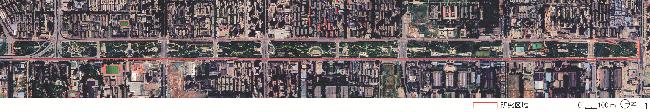
[Objective] Urban parks play a vital role in enhancing residents’ physical and mental well-being and offering leisure opportunities. Their vitality has become a crucial indicator of urban spatial quality and public welfare. Rapid urbanization has further intensified the imbalance in the allocation of public service resources. Existing research, which primarily relies on heat maps, mobile signaling data, or ground-based camera monitoring, can reveal macroscopic trends but fail to capture the dynamic spatiotemporal characteristics of crowd distribution at the micro scale. Meanwhile, aerial photography obtained through unmanned aerial vehicle (UAV) offers high spatial resolution and flexible data acquisition capabilities, while the advancement of object detection algorithms based on deep learning presents new technological opportunities for crowd recognition in complex urban environments. This research aims to develop and validate a micro-scale vitality measurement method for urban parks based on aerial time-series imagery and an improved object detection model. The method seeks to reveal the spatiotemporal patterns of crowd distribution, identify high-frequency vitality nodes and their driving mechanisms, and provide data support and strategic insights for optimizing the spatial layout, facility allocation, and refined management of parks. Taking Xi’an Xingfu Linear Park as an example, the research focuses on analyzing vitality intensity, fluctuation, and spatial balance at a fine spatiotemporal scale.
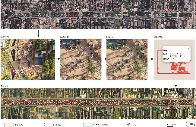
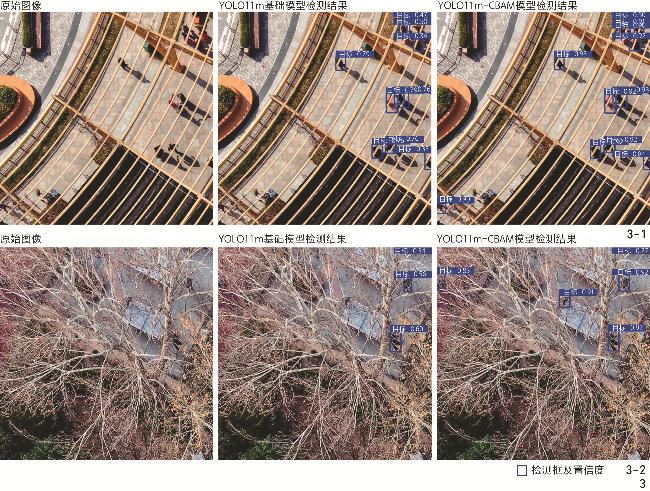
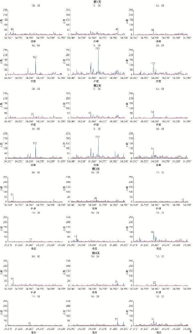
[Methods] Between March 27 and 30, 2025, continuous UAV-based aerial photography was conducted at a fixed altitude of 75 m during six standard time periods (08:00, 10:00, 12:00, 14:00, 16:00, 18:00), yielding over 2,300 high-resolution images. A manually annotated dataset of 2,000 sub-images with 12,340 pedestrian instances is constructed for model training. To address challenges of small-scale targets and complex occlusions in aerial imagery, an enhanced YOLO11m-CBAM model is developed by embedding a convolutional block attention module (CBAM) into YOLO11m. The improved model achieves notable performance gains: mAP50 increases from 77.1% to 81.3%, mAP50–95 from 45.6% to 51.7%, with precision and recall reaching 86.4% and 72.0% respectively, demonstrating enhanced robustness under medium and low occlusion conditions. Detection outputs are orthorectified to geographic coordinates to construct a structured spatiotemporal dataset. Spatial analysis employs kernel density estimation, coefficient of variation (CV), spatial Gini coefficient, and the “latitude-population” curve to characterize multidimensional vitality patterns.
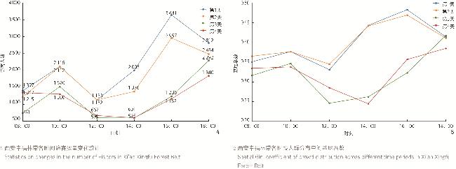
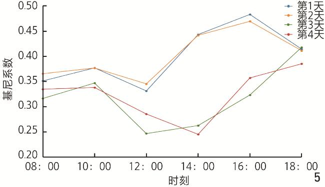
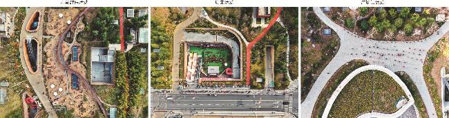
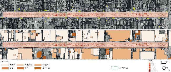
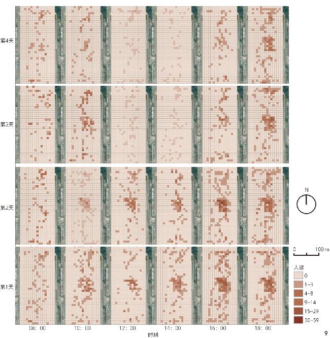
[Results] The temporal analysis results indicate that the overall utilization of Xingfu Forest Belt exhibits a distinct “dual-peak” pattern. On rest days, the number of visitors reaches 2,112 at 10:00 and 3,641 at 16:00, reflecting typical peaks of family and leisure activities. The daily coefficient of variation (CV = 38.67%) is relatively low, suggesting stable visiting patterns with activity concentrated in leisure hours. In contrast, on working days, vitality peaks occur at 10:00 and 18:00, corresponding to post-commuting and after-work relaxation periods, respectively. The higher daily visiting (CV = 55.34%) indicates a more uneven temporal distribution of activities. Notably, 12:00 represents the lowest point of visiting (the minimum number of visitors is only 595, and the average number is 883), implying underutilization of space during midday and suggesting potential opportunities for future facility optimization or time-specific programming. The spatial equilibrium analysis further reveals that during peak hours (14:00 and 16:00), the spatial Gini coefficient reaches 0.44 – 0.48, indicating a strong concentration of vitality in specific functional zones and a pronounced spatial polarization effect. In contrast, the Gini coefficient drops to 0.24 during off-peak periods (08:00 and 12:00), reflecting a more dispersed and evenly distributed use of space. At 18:00, the Gini coefficient remains between 0.38 and 0.41, suggesting a moderate level of aggregation in the evening. Overall, the vitality of Xingfu Forest Belt demonstrates a dynamic pattern of “daytime polarization with evening recovery”. In terms of spatial distribution, vitality hotspots are primarily concentrated along the central and northern segments of the belt, forming localized peaks. The emergence of these core areas is driven by two main factors: 1) the attraction of fixed functional facilities such as children’s play areas, fitness zones, and square-dancing spaces; and 2) the temporal aggregation generated by periodic activities, including weekend family events and morning exercise. At the macro scale, the concentration of residential and educational land uses, high accessibility to bus stops, and the scarcity of comparable recreational facilities jointly reinforce the sustained vitality of the central children’s play area. Maintaining consistently high footfall and strong spatial spillover effects across multiple time periods, this area serves as a key vitality hub within the overall spatial structure of Xingfu Forest Belt.
[Conclusion] The research demonstrates that the proposed UAV-based and YOLO-based vitality measurement framework provides high spatiotemporal resolution at the micro-park scale, enabling accurate identification of vitality hotspots, temporal fluctuations, and spatial imbalances. This approach offers an operational, quantitative basis for optimizing facility layouts, designing flexible spaces, and implementing differentiated management strategies. Methodological limitations are also discussed: The approach performs reliably in spring, autumn, and winter with low to moderate vegetation coverage, but may encounter partial omissions under dense canopy or multi-layer pergola structures in summer. To enhance applicability, future improvements include multi-drone and multi-view data acquisition, infrared thermal imaging to mitigate occlusion, air-ground data fusion, inter-frame trajectory matching to distinguish stay/pass behaviors, and fine-grained activity recognition. Overall, the proposed method provides a replicable technical pathway and empirical reference for refined park governance and smart park development. The findings contribute to advancing quantitative urban vitality assessment and provide methodological insights for integrating AI and spatial analysis in urban landscape research.
YAN Mingyu , WANG Fei . Dynamic Perception and Vitality Assessment of Crowds in Urban Parks Based on an Enhanced YOLO Object Detection Model: A Case Study of Xi’an Xingfu Forest Belt[J]. Landscape Architecture, 2025 , 32(12) : 45 -55 . DOI: 10.3724/j.fjyl.LA20250482
1、提出基于无人机航拍时序影像的人群动态测度方法,突破传统监测方法的精度局限,填补城市公园活力精细测度的研究缺口。
2、融合改进YOLO模型与地理坐标映射技术,构建高精度时空数据集,实现活力热点识别与动态分析,为城市景观规划与精细化管理提供数据支持。
3、揭示西安幸福林带活力“双峰式”时序规律与空间集聚特征,阐明设施与活动对活力的驱动机制,为设施优化与管理提供依据。
| [1] |
中华人民共和国住房和城乡建设部.城市绿地分类标准: CJJ/T 85—2017[S].北京: 中国建筑工业出版社, 2018: 2-6.
Ministry of Housing and Urban-Rural Development of the People’s Republic of China. Standard for Classification of Urban Green Space: CJJ/T 85−2017[S]. Beijing: China Architecture & Building Press, 2018: 2-6.
|
| [2] |
陶晓丽, 陈明星, 张文忠, 等 城市公园的类型划分及其与功能的关系分析: 以北京市城市公园为例[J]. 地理研究, 2013, 32 10 1964.-1976.
TAO X L, CHEN M X, ZHANG W Z, et al Classification and Its Relationship with the Functional Analysis of Urban Parks: Taking Beijing as an Example[J]. Geographical Research, 2013, 32 10 1964.-1976.
|
| [3] |
CHIESURA A The Role of Urban Parks for the Sustainable City[J]. Landscape and Urban Planning, 2004, 68 (1): 129.-138.
|
| [4] |
邵明, 李方正, 李雄 基于多源数据的成渝城市群绿色空间生态系统服务功能供需评价[J]. 风景园林, 2021, 28 (1): 60.-66.
SHAO M, LI F Z, LI X Evaluation of Supply and Demand of Green Space Ecosystem Service Function in Chengdu-Chongqing Urban Agglomeration Based on Multi-source Data[J]. Landscape Architecture, 2021, 28 (1): 60.-66.
|
| [5] |
JIA P, QIU Y L, GAUGHAN A E A Fine-Scale Spatial Population Distribution on the High-Resolution Gridded Population Surface and Application in Alachua County, Florida[J]. Applied Geography, 2014, 50: 99.-107.
|
| [6] |
WEI X M, QIAN Y, SUN C H, et al A Survey of Location-Based Social Networks: Problems, Methods, and Future Research Directions[J]. GeoInformatica, 2022, 26 (1): 159.-199.
|
| [7] |
任亚鹏, 刘启明, 刘馨, 等 30分钟社区生活圈视角下的武汉市主城区绿色空间公平性评价[J]. 风景园林, 2024, 31 11 94.-102.
REN Y P, LIU Q M, LIU X, et al Equity Evaluation of Green Space in the Central Urban Area of Wuhan from the Perspective of 30-Minute Community Life Circle[J]. Landscape Architecture, 2024, 31 11 94.-102.
|
| [8] |
赵晓龙, 徐靖然, 刘笑冰, 等 基于无人机(UAV)观测的寒地城市公园冬季体力活动及空间分布研究: 以哈尔滨四个公园为例[J]. 中国园林, 2019, 35 12 40.-45.
ZHAO X L, XU J R, LIU X B, et al Observations of Winter Physical Activities in Urban Parks Using UAVs: A Case Study of Four City Parks in Harbin[J]. Chinese Landscape Architecture, 2019, 35 12 40.-45.
|
| [9] |
ZHAO K X, ZHANG S B, LI E L, et al Research on the Evolution of Population Distribution and Influencing Factors in Xi’an During the COVID-19 Epidemic Control Period: Based on a Perspective of Multi-source Spatio-temporal Big Data[J]. IOP Conference Series: Earth and Environmental Science, 2021, 769 (2): 022066.
|
| [10] |
中华人民共和国住房和城乡建设部.城市绿地规划标准: GB/T 51346—2019[S].北京: 中国建筑工业出版社, 2019.
Ministry of Housing and Urban-Rural Development of the People’s Republic of China. Standard for Urban Green Space Planning: GB/T 51346−2019[S]. Beijing: China Architecture & Building Press, 2019.
|
| [11] |
JACOBS J. The Death and Life of Great American Cities[M]. Chichester: John Wiley & Sons, Ltd., 2015: 94-109.
|
| [12] |
GEHL J. Life Between Buildings: Using Public Space[M]. Washington, D. C.: Danish Architectural Press, 2008.
|
| [13] |
张赫, 贺晶, 杨天宇, 等 人群动态分布感知下的天津市公园活力特征及影响因素研究[J]. 风景园林, 2023, 30 (7): 36.-42.
ZHANG H, HE J, YANG T Y, et al Research on Vitality Characteristics and Influence Factors of Urban Parks in Tianjin Under the Perception of Dynamic Population Distribution[J]. Landscape Architecture, 2023, 30 (7): 36.-42.
|
| [14] |
朱震军, 曹湛, 和煜栋, 等 基于MGWR的轨道站点周边建成环境对街道活力影响研究[J]. 现代城市研究, 2024, 39 (9): 95.-99.
ZHU Z J, CAO Z, HE Y D, et al Research on the Influence of Built Environment Around Rail Transit Station on Street Vitality Based on MGWR[J]. Modern Urban Research, 2024, 39 (9): 95.-99.
|
| [15] |
魏迪, 陆毅, 汪原, 等 信息流介入公共空间活力营造: 基于城市公园的大数据循证分析[J]. 风景园林, 2023, 30 (7): 86.-93.
WEI D, LU Y, WANG Y, et al Intervention of Information Flow in the Creation of Public Space Vitality: An Evidence-Based Analysis of Big Data Based on Urban Parks[J]. Landscape Architecture, 2023, 30 (7): 86.-93.
|
| [16] |
何夏萱, 袁奇峰, 卢俊文, 等 基于多源大数据的广州市城市公园人群时空活动模式与规划策略研究[J]. 现代城市研究, 2025, 40 (1): 7.-14.
HE X X, YUAN Q F, LU J W, et al Research on the Spatiotemporal Activity Patterns and Planning Strategies of Urban Park Users in Guangzhou City Based on Multi-source Big Data[J]. Modern Urban Research, 2025, 40 (1): 7.-14.
|
| [17] |
钮心毅, 康宁 上海郊野公园游客活动时空特征及其影响因素: 基于手机信令数据的研究[J]. 中国园林, 2021, 37 (8): 39.-43.
NIU X Y, KANG N Spatio-temporal Characteristics and Influencing Factors of Tourist Activities in Shanghai Country Parks: A Study Based on Mobile Phone Signaling Data[J]. Chinese Landscape Architecture, 2021, 37 (8): 39.-43.
|
| [18] |
尹静一, 汤晓敏, 王云 人本视角下滨水公共空间活力评估与调控研究: 以上海黄浦江核心段为例[J]. 中国园林, 2022, 38 (9): 81.-86.
YIN J Y, TANG X M, WANG Y Research on the Vitality Evaluation and Regulation of Waterfront Public Space from the Perspective of Humanism: A Case Study of the Core Section of Huangpu River in Shanghai as an Example[J]. Chinese Landscape Architecture, 2022, 38 (9): 81.-86.
|
| [19] |
邹闻婷.城市公园空间活力多维综合评估及影响因素探究: 以南京市中心城区为例[D].南京: 东南大学, 2021.
ZOU W T. Multidimensional Comprehensive Evaluation of Urban Park Space Vitality and Its Influencing Factors: A Case Study of Downtown Nanjing[D]. Nanjing: Southeast University, 2021.
|
| [20] |
OUYANG J N, FAN H, WANG L Y, et al Revealing Urban Vibrancy Stability Based on Human Activity Time-Series[J]. Sustainable Cities and Society, 2022, 85: 104053.
|
| [21] |
盛强, 方可 基于多源数据空间句法分析的数字化城市设计: 以武汉三阳路城市更新项目为例[J]. 国际城市规划, 2018, 33 (1): 52.-59.
SHENG Q, FANG K Digital Urban Design Using Space Syntax Analysis Based on Multi-source Data: An Urban Renewal Project in Wuhan Sanyanglu Area[J]. Urban Planning International, 2018, 33 (1): 52.-59.
|
| [22] |
WANG J M, HUANG K, PI J Y. RUP2S-YOLO: An Improved YOLOv8-Based Algorithm for Dense Pedestrian Detection[C]//Institute of Electrical and Electronics Engineers. 2024 5th International Seminar on Artificial Intelligence, Networking and Information Technology. Piscataway: IEEE, 2024: 667-671.
|
| [23] |
YANG D B, GONZALEZ-BANOS H H, GUIBAS L J. Counting People in Crowds with a Real-Time Network of Simple Image Sensors[C]//Institute of Electrical and Electronics Engineers. Proceedings Ninth IEEE International Conference on Computer Vision. Piscataway: IEEE, 2003: 122-129.
|
| [24] |
陈海秀, 陈子昂, 房威志, 等.复杂场景下的改进YOLOv8-n密集行人检测模型[J/OL].计算机工程, 1-12[2025-08-08].https://doi.org/10.19678/j.issn.1000-3428.0070531.
CHEN H X, CHEN Z A, FANG W Z, et al. An Improved Dense Pedestrian Detection Algorithm Based on YOLOv8-n in Complex Scenes[J/OL]. Computer Engineering, 1-12[2025-08-08]. https://doi.org/10.19678/j.issn.1000-3428.0070531.
|
| [25] |
郭睿, 乐艳艳, 刁志强, 等 “双碳”视角下西安幸福林带项目植物碳储量及优化策略[J]. 现代园艺, 2023 22 182.-183.
GUO R, LE Y Y, DIAO Z Q, et al Plant Carbon Storage and Optimization Strategy of Xi’an Happiness Forest Belt Project from the Perspective of “Double Carbon”[J]. Contemporary Horticulture, 2023 22 182.-183.
|
| [26] |
陈海山, 梁裕珩 人口集聚与植被恢复: 基于人口空间分布的实证研究[J]. 经济学(季刊), 2023, 23 (5): 2025.-2041.
CHEN H S, LIANG Y H Population Agglomeration and Vegetation Restoration: An Empirical Study Based on Population Spatial Distribution[J]. China Economic Quarterly, 2023, 23 (5): 2025.-2041.
|
| [27] |
GHOSE D, DESAI S M, BHATTACHARYA S, et al. Pedestrian Detection in Thermal Images Using Saliency Maps[C]//Institute of Electrical and Electronics Engineers. 2019 IEEE/CVF Conference on Computer Vision and Pattern Recognition Workshops. Piscataway: IEEE, 2019: 988-997.
|
/
| 〈 |
|
〉 |