
From Viewpoint to Space: Quantitative Analysis Method for Visual Characteristics of Landscape Space Based on Point Cloud
|
ZHANG Xiaohan is a Ph.D. candidate in the School of Engineering and Design, Technical University of Munich. His research focuses on urban green infrastructure, digital landscape and technology, and landscape planning and design |
|
CHENG Ziqian is a Ph.D. candidate in the School of Architecture, Southeast University. Her research focuses on digital landscape and technology, and landscape planning and design |
|
ZHANG Ning is a Ph.D. candidate in the School of Architecture, Southeast University. Her research focuses on digital landscape and technology, and landscape planning and design |
Received date: 2023-12-13
Revised date: 2024-05-31
Online published: 2025-12-17
Copyright
Visual characteristics of landscape space are one of the criteria for measuring the quality of landscape space. The in-depth investigation of the quantitative analysis method for visual characteristics of landscape space will assist designers in accurately recognizing the spatial form of landscape space, and provide support for the design of high-quality landscape space. Previous scholars have conducted numerous studies on the association between landscape visual characteristics and human perception, proposed different assessment indicators for describing visual characteristics of landscapes, and confirmed that the visual characteristics of landscape space play an important role in predicting people’s preference for a specific landscape space as well as their potential activity behaviors. However, the previous analysis methods based on 3D models or 2D photographs can hardly take into account the quantitative analysis of the spatial information of visual interface in both the plane and depth dimensions, which is less applicable in the research and design practice regarding the spatial visual characteristics of large-scale urban parks. Although the point cloud model is highly accurate, the quantification method based on point cloud voxelization entails long-time computing, and there are still some difficulties in the quantitative analysis of spatial visual characteristics of large-scale urban green landscapes. Therefore, this research aims to propose a quantitative analysis method for the visual characteristics of landscape space based on point cloud and visualization algorithms. On the basis of retaining the high-precision spatial data of the point cloud model, this method has high computational efficiency and can meet the demand for quantitative analysis of 2D and 3D visual characteristics.
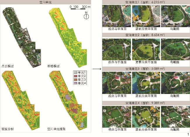
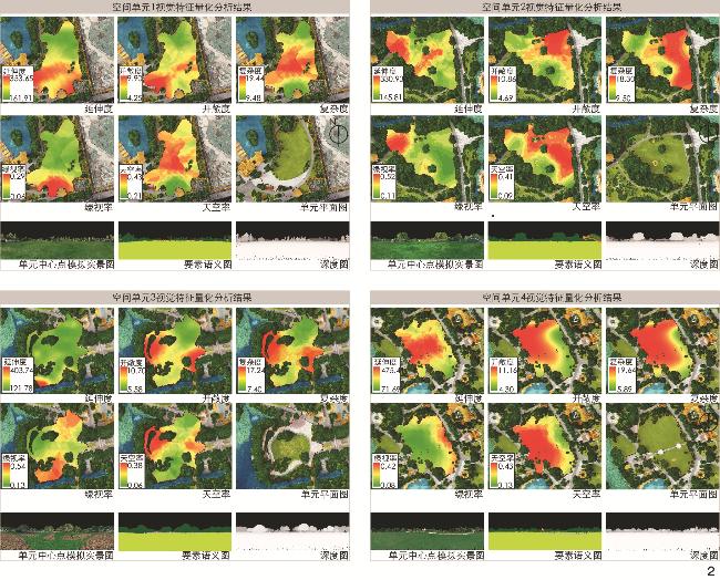
Based on previous research on the quantification of landscape spatial morphology, this research combines the point cloud visualization with the spatial analysis function in ArcGIS and calculates multiple visual indicators by simulating the visual interface of multiple viewpoints in landscape space, thus realizing the computation and visualization of the visual characteristics of landscape space. The method is mainly divided into four steps, including point cloud model data acquisition and processing, spatial unit delineation and viewpoint generation, visual simulation and characteristic indicator calculation, and visualization and analysis of the visual characteristics of spatial units. First, point cloud model data are acquired by virtue of unmanned aerial vehicle (UAV) oblique photography and classified into a total of seven categories: Trees and shrubs, ground cover, lawn, hard ground, water surface, buildings, and others. Second, spatial units are identified by slope analysis in ArcGIS, and viewpoints are generated using the fishing net tool created in ArcGIS. Using the point cloud visualization and depth image tools in Point Cloud Library (PCL), the visual interface of each viewpoint is simulated, and the depth value and semantic value corresponding to each pixel point of the 2D image are extracted, which can be computed for multiple visual characteristic indicators. Five visual characteristic indicators (extension, openness, complexity, green visibility, and sky ratio) mostly used in previous research, are selected as examples. Relevant calculation formulas and methods are developed according to the proposed method. Finally, upon calculation of the visual characteristic indicators of each viewpoint, corresponding viewpoint properties are added to the viewpoint object in ArcGIS, and the calculated indicator values are imported into the characteristic table. Additionally, the Kriging interpolation tool in ArcGIS is adopted to generate a color raster map of each indicator.
In order to verify the feasibility of the proposed method, Qinglvyuan Park in Najing is taken as an example to explore the application of the method. Four spatial units with an area larger than 0.5 hm2 are extracted for quantitative analysis. From the results, the visual characteristics of the four spatial units differ significantly. The spatial distribution characteristics of each visual indicator in the spatial units are weakly correlated with the plane geometry of such units. Although the value of each visual characteristic indicator continuously changes in space, the distribution locations of the peak and valley values are related to the elements inside the space (e.g., internal trees). Compared with previous analysis methods, the proposed method can more comprehensively and intuitively show the distribution of the indicator values and continuous changes of multiple visual characteristics in space, and has the potential to comprehensively analyze multiple characteristics based on the quantitative analysis of multiple visual characteristics.
The point cloud visualization method can replace the manual photographs taken in the landscape environment, and it can obtain spatial information on the depth of visual interface that cannot be fully covered by the photographs. Although it has certain advantages over traditional methods in terms of the efficiency and accuracy of visual interface simulation and analysis, there are some shortcomings in terms of the data acquisition method of the point cloud model, the rules of parameter setting, and the applicability to landscape spaces with different scales. This method has certain application prospects in the fields of exploring the correlation mechanism between the visual characteristics of landscape space and the behavioral preferences of crowds, predicting the behavioral activities of crowds, and designing the interaction between people and the environment.
Xiaohan ZHANG , Ziqian CHENG , Ning ZHANG . From Viewpoint to Space: Quantitative Analysis Method for Visual Characteristics of Landscape Space Based on Point Cloud[J]. Landscape Architecture, 2024 , 31(7) : 115 -121 . DOI: 10.3724/j.fjyl.202312130563
表1 景观空间视觉特征指标描述与计算方法Tab. 1 Description and calculation method of visual characteristic indicators for landscape space |
| 指标 | 描述 | 计算式 | 备注 |
| 延伸度 | 人视野范围所见要素深度的最大值,数值大小反映空间在纵深方向的延伸程度 | $ {E}_{\mathrm{s}}={d}_{i\mathrm{m}\mathrm{a}\mathrm{x}} $ | $E_ {\rm{s}} $为延伸度,$d_{i\max} $为去除天空后剩余各像素点的深度数值的最大值 |
| 开敞度 | 人视野范围内的要素距离人眼的平均距离,反映人对空间整体视觉尺度的感知 | $ {D}_{\mathrm{A}}={\displaystyle\sum }_{i=1}^{n}\dfrac{{d}_{i}}{n} $ | $D_ {\rm{A}} $为开敞度,$n $为去除天空后的像素点数量,$d_ i $为去除天空后剩余各像素点的深度数值 |
| 复杂度 | 人视野范围内各要素深度值的方差,用来描述空间视觉界面在纵深方向的变化(凹凸)程度 | $ {V}_{\mathrm{d}}={\displaystyle\sum }_{i=1}^{n}\dfrac{({d}_{i}-{D}_{\mathrm{A}}{)}^{2}}{n} $ | $ V_ {\rm{d}} $为复杂度,$ D_ {\rm{A}} $为开敞度,$ n $为去除天空后的像素点数量,$ d_i $为去除天空后剩余各像素点的深度数值 |
| 绿视率 | 人视野中植被(乔、灌木)面积占总视野面积的比例 | $ {R}_{\mathrm{G}}=\dfrac{{S}_{\mathrm{G}}}{{S}_{\mathrm{w}}} $ | $R_ {\rm{G}} $为绿视率,$S_ {\rm{G}} $为视野成像中的植被面积,$S_ {\rm{w}} $为总视野成像面积 |
| 天空率 | 人视野中天空面积占总视野面积的比例,亦称作天空开阔度 | $ {R}_{\mathrm{s}}=\dfrac{{S}_{\mathrm{s}}}{{S}_{\mathrm{w}}} $ | $R_ {\rm{s}} $为天空率,$S_ {\rm{s}} $为视野成像中的天空面积,$S_ {\rm{w}} $为总视野成像面积 |
文中图表均由作者绘制。
| [1] |
MADUREIRA H, NUNES F, OLIVEIRA J V, et al. Urban Residents’ Beliefs Concerning Green Space Benefits in Four Cities in France and Portugal[J]. Urban Forestry & Urban Greening, 2015, 14(1): 56-64.
|
| [2] |
邵钰涵, 薛贞颖, 蒿奕颖, 等. 城市公园视听感知品质评价研究: 以成都环城生态区为例[J]. 风景园林, 2022, 29(9): 26-32.
SHAO Y H, XUE Z Y, HAO Y Y, et al. Research on Evaluation of Audio-Visual Perception Quality of Urban Parks: A Case Study of Chengdu Outer-Ring Ecological Zone[J]. Landscape Architecture, 2022, 29(9): 26-32.
|
| [3] |
ZHANG G, YANG J, WU G, et al. Exploring the Interactive Influence on Landscape Preference from Multiple Visual Attributes: Openness, Richness, Order, and Depth[J]. Urban Forestry & Urban Greening, 2021, 65: 127363.
|
| [4] |
GRAHN P, STIGSDOTTER U K. The Relation Between Perceived Sensory Dimensions of Urban Green Space and Stress Restoration[J]. Landscape and Urban Planning, 2010, 94(3-4): 264-275.
|
| [5] |
TVEIT M, ODE Å, FRY G. Key Concepts in a Framework for Analyzing Visual Landscape Character[J]. Landscape Research, 2006, 31(3): 229-255.
|
| [6] |
PURCELL A T, LAMB R J. Preference and Naturalness: An Ecological Approach[J]. Landscape and Urban Planning, 1998, 42(1): 57-66.
|
| [7] |
GOBSTER P H. An Ecological Aesthetic for Forest Landscape Management[J]. Landscape Journal, 1999, 18(1): 54-64.
|
| [8] |
成实, 王建国. 基于动态观览评价的视觉景观研究探索: 以南京市滨江型公共空间为例[J]. 中国园林, 2021, 37(11): 57-62.
CHENG S, WANG J G. Visual Landscape Research on Dynamic Viewing Evaluation: A Case Study of Nanjing Riverside Public Viewing Space[J]. Chinese Landscape Architecture, 2021, 37(11): 57-62.
|
| [9] |
LIU Q, ZHU Z, ZENG X, et al. The Impact of Landscape Complexity on Preference Ratings and Eye Fixation of Various Urban Green Space Settings[J]. Urban Forestry & Urban Greening, 2021, 66: 127411.
|
| [10] |
HERZOG T R. A Cognitive Analysis of Preference for Urban Nature[J]. Journal of Environmental Psychology, 1989, 9(1): 27-43.
|
| [11] |
ZHAO Y, WU B, WU J, et al. Mapping 3D Visibility in an Urban Street Environment from Mobile LiDAR Point Clouds[J]. GIScience & Remote Sensing, 2020, 57(6): 797-812.
|
| [12] |
BERNARD J, BOCHER E, PETIT G, et al. Sky View Factor Calculation in Urban Context: Computational Performance and Accuracy Analysis of Two Open and Free GIS Tools[J]. Climate, 2018, 6(3): 60.
|
| [13] |
SUGIYAMA T, THOMPSON C W. Older People’s Health, Outdoor Activity and Supportiveness of Neighborhood Environments[J]. Landscape and Urban Planning, 2007, 83(2-3): 168-175.
|
| [14] |
米勒, 刘滨谊, 唐真. 从视觉偏好研究: 一种理解景观感知的方法[J]. 中国园林, 2013, 29(5): 22-26.
MILLER P A, LIU B Y, TANG Z. Visual Preference Research: An Approach to Understanding Landscape Perception[J]. Chinese Landscape Architecture, 2013, 29(5): 22-26.
|
| [15] |
罗涛, 徐婵娟, 蓝思琪, 等. 城市视觉景观公众偏好特征研究[J]. 中国园林, 2023, 39(11): 15-21.
LUO T, XU C J, LAN S Q, et al. Study on the Characteristics of Public Preference of Urban Visual Landscape[J]. Chinese Landscape Architecture, 2023, 39(11): 15-21.
|
| [16] |
陈崇贤, 李海薇, 侯咏淇, 等. 计算机视觉技术在景观与健康关系研究中的应用进展[J]. 风景园林, 2023, 30(1): 30-37.
CHEN C X, LI H W, HOU Y Q, et al. Application Progress of Computer Vision in the Research on Relationship Between Landscape and Health[J]. Landscape Architecture, 2023, 30(1): 30-37.
|
| [17] |
陈筝. 高密高异质性城市街区景观对心理健康影响评价及循证优化设计[J]. 风景园林, 2018, 25(1): 106-111.
CHEN Z. Assessing the Impact of High-Density High-Heterogeneity Urban District Landscape on Psychological Health and Optimizing via Evidence-Based Design[J]. Landscape Architecture, 2018, 25(1): 106-111.
|
| [18] |
周详, 徐浩洋. 图像深度学习技术支持下南京秦淮河滨水景观视觉质量评价研究[J]. 中国园林, 2022, 38(S2): 84-87.
ZHOU X, XU H Y. Research on the Visual Landscape Quality Assessment of Qinhuai River Waterfront Landscape in Nanjing with the Support of Image Deep Learning Technology[J]. Chinese Landscape Architecture, 2022, 38(S2): 84-87.
|
| [19] |
李小江, 蔡洋, 拉蒂, 等. 基于街道图像与深度学习的城市景观研究[J]. 景观设计学, 2018, 6(2): 20-29.
LI X J, CAI Y, RATTI C. et al. Using Street-Level Images and Deep Learning for Urban Landscape Studies[J]. Landscape Architecture Frontiers, 2018, 6(2): 20-29.
|
| [20] |
ZHANG X, LIN E S, TAN P Y, et al. Assessment of Visual Landscape Quality of Urban Green Spaces Using Image-Based Metrics Derived from Perceived Sensory Dimensions[J]. Environmental Impact Assessment Review, 2023, 102: 107200.
|
| [21] |
RUI Q, CHENG H. Quantifying the Spatial Quality of Urban Streets with Open Street View Images: A Case Study of the Main Urban Area of Fuzhou[J]. Ecological Indicators, 2023, 156: 111204.
|
| [22] |
QI J D, LIN E S W, TAN P Y, et al. Development and Application of 3D Spatial Metrics Using Point Clouds for Landscape Visual Quality Assessment[J]. Landscape and Urban Planning, 2022, 228: 104585.
|
| [23] |
BISHOP I D. Assessment of Visual Qualities, Impacts, and Behaviors, in the Landscape, by Using Measures of Visibility[J]. Environment and Planning B: Planning and Design, 2003, 30(5): 677-688.
|
| [24] |
YOKOYA N, NAKAZAWA S, MATSUKI T, et al. Fusion of Hyperspectral and LiDAR Data for Landscape Visual Quality Assessment[J]. IEEE Journal of Selected Topics in Applied Earth Observations and Remote Sensing, 2014, 7(6): 2419-2425.
|
| [25] |
LIU M, NIJHUIS S. Mapping Landscape Spaces: Methods for Understanding Spatial-Visual Characteristics in Landscape Design[J]. Environmental Impact Assessment Review, 2020, 82: 106376.
|
| [26] |
谭立, 黄楚梨, 李慧, 等. 复杂地形环境下路径视觉关系评价研究[J]. 风景园林, 2020, 27(3): 75-79.
TAN L, HUANG C L, LI H, et al. Research on Visual Relationship Evaluation of Trails in Complex Terrains[J]. Landscape Architecture, 2020, 27(3): 75-79.
|
| [27] |
柯彦, 林月彬, 林碧英, 等. 基于ArcGIS的“登山观城”眺望景观优化控制研究: 以福州福道为例[J]. 中国园林, 2021, 37(12): 43-47.
KE Y, LIN Y B, LIN B Y, et al. Research on the Optimization Control of Overlooking Landscape from Mountain to City: A Case Study of Fu Forest Trail in Fuzhou[J]. Chinese Landscape Architecture, 2021, 37(12): 43-47.
|
| [28] |
ZHANG X D, LIN E S W, QI J D, et al. Linking Image-Based Metrics to 3D Model-Based Metrics for Assessment of Visual Landscape Quality[J]. Journal of Digital Landscape Architecture, 2023, 8(1): 167-177.
|
| [29] |
WANG Y, CHENG Y, ZLATANOVA S, et al. Identification of Physical and Visual Enclosure of Landscape Space Units with the Help of Point Clouds[J]. Spatial Cognition & Computation, 2020, 20(3): 257-279.
|
| [30] |
APPLETON J. Prospects and Refuges Re-visited[J]. Landscape Journal, 1984, 3(2): 91-103.
|
/
| 〈 |
|
〉 |