
Method for Quantitative Analysis of Visual Space of Chinese Traditional Gardens Based on LiDAR Point Cloud: A Case Study of Jichang Garden
|
ZHANG Guanting (Zhuang), Ph.D., is a lecturer in the College of Architecture, Nanjing Tech University. Her research focuses on digital landscape, visual landscape, quantitative analysis of landscape spaces, and landscape design and planning |
|
PENG Yuyang, Master, is an assistant research fellow in the Faculty of Architecture and the Built Environment, Delft University of Technology. His research focuses on digital landscape, visual landscape, heritage landscape, and landscape design and planning |
|
(NLD) Steffen Nijhuis, Ph.D., is a full professor in the Faculty of Architecture and the Built Environment, and leader of Landscape Architecture Section, Delft University of Technology. His research focuses on landscape-based urbanism, regional landscape design, sustainable urban development, design with natural processes, resilient coastal landscape, heritage landscape, digital landscape, and visual landscape |
Received date: 2024-01-07
Revised date: 2024-05-26
Online published: 2025-12-17
Copyright
Human perception of landscape and environment is primarily through visual senses, making visual landscape research a central theme in landscape architecture research. Conducting a visual analysis of the spatial characteristics of traditional Chinese gardens and exploring their visual features can provide valuable guidance for inheriting the essence of spatial design. In recent years, many scholars have employed quantitative analytical methods to identify the visual space of traditional gardens. However, few of these studies have used detailed models to analyze the spatial features of traditional garden spaces. Compared to traditional digital models, point cloud models collected through LiDAR (light detection and ranging) offer more detailed spatial information for visual landscape research. Therefore, this research aims to take Jichang Garden in Wuxi as an example to explore the possibilities and applications of in-depth visual and spatial analysis of traditional Chinese gardens using point cloud technology. This aim can be further broken into several components: 1) Establishing analytical methods and selecting analysis indicators; 2) applying these methods and indicators to analyze the visual space of Jichang Garden; 3) uncovering the characteristics and features of traditional Chinese gardens through the interpretation of analysis results.
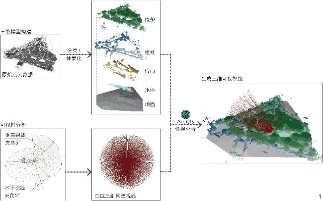
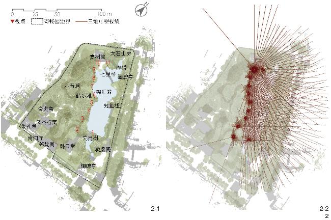
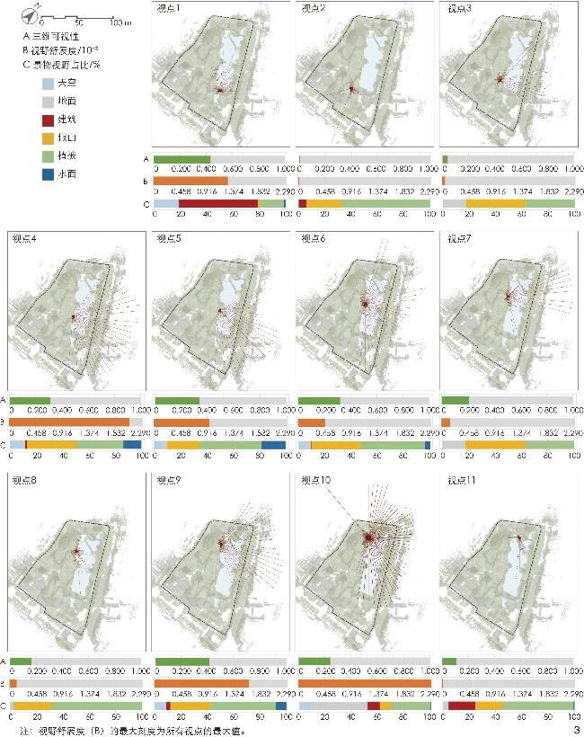
This research establishes a set of methods for quantifying the analysis of visual space using point cloud data, including three main steps. 1) Establishment of a model based on point cloud for calculating the analysis results of visual space. In detail, this research applies a voxel-based method to build multidimensional digital models for buildings, vegetation, and rockery, and build a digital elevation model (DEM) based on the point cloud data on the ground. Then, the aforesaid two kinds of models are integrated with water surface to finalize the modeling process. 2) Establishment of a visual analysis method (line of sight method) based on the three-dimensional digital model for obtaining visual space information. 3) Proposal of indicators for evaluating visual landscape utilizing the visual space information obtained, including “3D visibility”, “visual spread” and “feature ratio of visual field” indicators. A total of 11 viewpoints (viewpoints 1, 2, 3 ... 11) on the west side of Jinhuiyi Pond are analyzed using the above methods.
This research’s main findings consist of three parts. 1) 3D visibility calculation results. From the visibility analysis results of 11 viewpoints, it is evident that viewpoints 1, 5, 6, 7, and 10 have a relatively broad visual field, with some line of sight reaching a length of 100 meters. 2) Evaluation results of visual space indicators. The viewpoint with the highest 3D visibility is labeled as viewpoint 1, located at the Xianyuexie water viewing platform, while the one with the minimum 3D visibility is labeled as viewpoint 2. The viewpoint with the highest “visual spread” is viewpoint 10, situated in the plaza at the south of the Jiashutang building, while the one with the minimum “visual spread” is viewpoint 11. Except for viewpoint 1 (dominated by buildings) and viewpoint 10 (dominated by the ground), the highest “feature ratio of visual field” is occupied by vegetation. 3) Interpretation of the calculation results. Firstly, the research interprets the reasons for forming a scenic view from a single viewpoint. “3D visibility” can be used to identify the scale of the visual field in gardens. At the same time, the “feature ratio of visual field” can be employed to analyze the factors contributing to the scale of visual space. Moreover, incorporating the “visual spread” indicator further makes it possible to identify the morphological features of visual space in traditional gardens. Secondly, the research explores route-based visual space transitions. From the perspective of landscape sequence, visitors, starting from the Xianyuexie water viewing platform and passing through Hebutan (a small pond) to reach the Jiashutang building, undergo at least the following spatial perception processes. 1) Xianyuexie – woody path (near Jiushitai): Visitors transition from the lake viewing space beside the Xianyuexie building to the enclosed space surrounded by a group of trees along the path. 2) Woody path – Hebutan: Visitors experience a shift from a relatively enclosed environment to a more open water viewing space. The peak of this water viewing experience occurs near viewpoint 5 (Hebutan), a space with water on three sides. 3) Hebutan – waterside path (near Bayinjian): Visitors’ experience transitions from an open water viewing space to a more enclosed space where the view of the lake is obstructed by plants, enriching the water viewing experience and preventing aesthetic fatigue resulting from continuous exposure to similar spatial environments. 4) Waterside path– Jiashutang: Visitors’ experience evolves from a closed, plant-dominated space to a gradually more open lake viewing space in front of the Jiashutang building, serving as the endpoint of the entire perceptual space sequence on the west side of Jinhuiyi Pond.
In summary, the conclusions of this research are as follows: Firstly, point cloud technology has a specific feasibility for analyzing the spatial and visual characteristics of traditional Chinese gardens, and its high accuracy and precision make it suitable for handling the complex and varied spatial conditions of traditional Chinese gardens. Secondly, the three visual space indicators proposed in this research have a solid capability for explaining the characteristics of garden space.
Guanting ZHANG , Yuyang PENG , (NLD) Steffen Nijhuis . Method for Quantitative Analysis of Visual Space of Chinese Traditional Gardens Based on LiDAR Point Cloud: A Case Study of Jichang Garden[J]. Landscape Architecture, 2024 , 31(7) : 108 -114 . DOI: 10.3724/j.fjyl.202401070015
表1 各视点视觉空间指标计算结果Tab. 1 Calculation results of visual space indicators for each viewpoint |
| 视点 | 三维可视性 | 舒展度/10-3 | 景物视野占比/% | |||||
| 植被 | 建筑 | 假山 | 水体 | 地面 | 天空 | |||
| 1 | 0.434 | 1.284 | 18.238 | 59.837 | 1.340 | 1.485 | 0.144 | 18.956 |
| 2 | 0.008 | 0.022 | 66.778 | 5.888 | 26.999 | 0 | 0.144 | 0.191 |
| 3 | 0.042 | 0.055 | 37.099 | 0 | 45.428 | 0 | 15.845 | 1.628 |
| 4 | 0.313 | 2.074 | 35.902 | 1.101 | 37.482 | 13.595 | 2.346 | 9.574 |
| 5 | 0.336 | 0.954 | 47.008 | 0.431 | 24.557 | 18.334 | 3.112 | 6.558 |
| 6 | 0.320 | 0.469 | 48.684 | 0.239 | 37.195 | 4.356 | 3.447 | 6.079 |
| 7 | 0.209 | 0.156 | 68.550 | 0.096 | 28.674 | 0.095 | 0 | 2.585 |
| 8 | 0.163 | 0.126 | 50.311 | 0.144 | 41.599 | 3.733 | 0 | 4.213 |
| 9 | 0.409 | 1.633 | 49.497 | 2.920 | 30.732 | 7.851 | 0 | 9.000 |
| 10 | 0.242 | 2.290 | 30.062 | 9.095 | 8.234 | 0.574 | 43.801 | 8.234 |
| 11 | 0.107 | 0.018 | 54.189 | 20.249 | 20.345 | 0.717 | 0 | 4.500 |
| 平均值 | 0.235 | 0.631 | 46.029 | 9.091 | 27.508 | 4.609 | 6.258 | 6.502 |
| 最小值 | 0.008 | 0.018 | 18.238 | 0.000 | 1.340 | 0 | 0 | 0.191 |
| 最大值 | 0.434 | 2.074 | 68.550 | 59.837 | 45.428 | 18.334 | 43.801 | 18.956 |
文中图表均由作者绘制,其中
| [1] |
BELL S. Landscape: Pattern, Perception and Process[M]. London: Routledge, 2012.
|
| [2] |
NIJHUIS S, VAN LAMMEREN R, VAN DER HOEVEN F. Exploring the Visual Landscape: Advances in Physiognomic Landscape Research in the Netherlands[M]. Amsterdam: IOS Press, 2011.
|
| [3] |
胡晓宇.中国江南私家园林与英国自然风景式园林风格比较初探[D].重庆: 重庆大学, 2007.
HU X Y. A Comparative Study on Gardening Style Between Chinese Private Garden and English Natural Landscaped Garden[D]. Chongqing: Chongqing University, 2007.
|
| [4] |
金鼎.中国古典园林空间构形及可理解度之量化分析[D].天津: 天津大学, 2009.
JIN D. Quantitative Analysis of Space Configuration and Intelligibility in Chinese Traditional Garden: Southern Private Garden for Example[D]. Tianjin: Tianjin University, 2009.
|
| [5] |
魏胜林, 刘海燕. 拙政园造园要素空间特征的量化研究[J]. 中国园林, 2015, 31(7): 78-82.
WEI S L, LIU H Y. Quantitative Study of Spatial Characteristics of Elements in Landscape Architecture of the Humble Administrator’s Garden[J]. Chinese Landscape Architecture, 2015, 31(7): 78-82.
|
| [6] |
乐志, 梁晓娜, 范榕. 苏州古典园林中的视觉质量评价分析[J]. 中国园林, 2017, 33(1): 113-118.
YUE Z, LIANG X N, FAN R. The Application of Landscape Visual Quality Assessment Theory in Classical Gardens of Suzhou[J]. Chinese Landscape Architecture, 2017, 33(1): 113-118.
|
| [7] |
张甜甜, 刘滨谊, 朱喆, 等. 网师园“步移景异”时空感知生成机理[J]. 中国园林, 2023, 39(11): 22-28.
ZHANG T T, LIU B Y, ZHU Z, et al. The Spatio-Temporal Perception Formation Mechanism of the “View Changes with Step Movements” in the Master of the Nets Garden[J]. Chinese Landscape Architecture, 2023, 39(11): 22-28.
|
| [8] |
顾至欣, 张青萍. 近20年国内苏州古典园林研究现状及趋势: 基于CNKI的文献计量分析[J]. 中国园林, 2018, 34(12): 73-77.
GU Z X, ZHANG Q P. Research Status and Future Trends of Domestic Studies on Suzhou Classical Gardens in the Past Two Decades: Bibliometric Analysis Based on CNKI[J]. Chinese Landscape Architecture, 2018, 34(12): 73-77.
|
| [9] |
LU L, LIU M. Exploring a Spatial-Experiential Structure Within the Chinese Literati Garden: The Master of the Nets Garden as a Case Study[J]. Frontiers of Architectural Research, 2023, 12(5): 923-946.
|
| [10] |
URECH P R W, DISSEGNA M A, GIROT C, et al. Point Cloud Modeling as a Bridge Between Landscape Design and Planning[J]. Landscape and Urban Planning, 2020, 203: 103903.
|
| [11] |
VUKOMANOVIC J, SINGH K K, PETRASOVA A, et al. Not Seeing the Forest for the Trees: Modeling Exurban Viewscapes with LiDAR[J]. Landscape and Urban Planning, 2018, 170: 169-176.
|
| [12] |
ZHANG G T, VERBREE E, WANG X J. An Approach to Map Visibility in the Built Environment From Airborne LiDAR Point Clouds[J]. IEEE Access, 2021, 9: 44150-44161.
|
| [13] |
ZHAO Y, WU B, WU J P, et al. Mapping 3D Visibility in an Urban Street Environment from Mobile LiDAR Point Clouds[J]. GIScience & Remote Sensing, 2020, 57(6): 797-812.
|
| [14] |
成实, 张冠亭, 张潇涵, 等. 基于LiDAR点云的景观空间“绿视率”量化分析方法研究[J]. 中国园林, 2022, 38(2): 12-19.
CHENG S, ZHANG G T, ZHANG X H, et al. Research on the Quantitative Analysis Method of “Green Viewing Ratio” of Landscape Spatial Form Based on Three-dimensional LiDAR Point Cloud Data[J]. Chinese Landscape Architecture, 2022, 38(2): 12-19.
|
| [15] |
DAI L Y, ZHENG C L, DONG Z K, et al. Analyzing the Correlation Between Visual Space and Residents’ Psychology in Wuhan, China Using Street-View Images and Deep-Learning Technique[J]. City and Environment Interactions, 2021, 11: 100069.
|
| [16] |
杨晨, 韩锋. 数字化遗产景观: 基于三维点云技术的上海豫园大假山空间特征研究[J]. 中国园林, 2018, 34(11): 20-24.
YANG C, HAN F. Digital Heritage Landscape: Research on Spatial Character of the Grand Rockery of Yuyuan Garden in Shanghai Based on 3D Point Cloud Technologies[J]. Chinese Landscape Architecture, 2018, 34(11): 20-24.
|
| [17] |
张青萍, 梁慧琳, 李卫正, 等. 数字化测绘技术在私家园林中的应用研究[J]. 南京林业大学学报(自然科学版), 2018, 42(1): 1-6.
ZHANG Q P, LIANG H L, LI W Z, et al. Research of the Application of Digital Survey Techniques in Private Garden[J]. Journal of Nanjing Forestry University (Natural Sciences Edition), 2018, 42(1): 1-6.
|
| [18] |
吴杭彬, 韦朝旭, 杨晨, 等. 基于激光点云的园林假山遗产特征定量化评价[J]. 园林, 2022, 39(10): 28-35.
WU H B, WEI Z X, YANG C, et al. Quantitative Evaluation of Garden Rockery Heritage Characteristics Based on Laser Point Cloud[J]. Landscape Architecture Academic Journal, 2022, 39(10): 28-35.
|
| [19] |
PENG Y Y, NIJHUIS S, ZHANG G T, et al. Towards a Practical Method for Voxel-Based Visibility Analysis with Point Cloud Data for Landscape Architects: Jichang Garden (Wuxi, China) as an Example[J]. Journal of Digital Landscape Architecture, 2022, 7(7): 682-691.
|
| [20] |
PENG Y Y, ZHANG G T, NIJHUIS S, et al. Towards a Framework for Point-Cloud-Based Visual Analysis of Historic Gardens: Jichang Garden as a Case Study[J]. Urban Forestry & Urban Greening, 2024, 91: 128159.
|
| [21] |
ALSADIK B, GERKE M, VOSSELMAN G. Visibility Analysis of Point Cloud in Close Range Photogrammetry[C]// ISPRS Technical Commission. ISPRS Annals of Photogrammetry, Remote Sensing and Spatial Information Sciences. Riva del Garda: ISPRS, 2014: 9-16.
|
| [22] |
LIU M, NIJHUIS S. Talking About Landscape Spaces. Towards a Spatial-Visual Landscape Design Vocabulary[J]. The Design Journal, 2022, 25(2): 263-281.
|
| [23] |
SHACH-PINSLY D, FISHER-GEWIRTZMAN D, BURT M. Visual Exposure and Visual Openness: An Integrated Approach and Comparative Evaluation[J]. Journal of Urban Design, 2011, 16(2): 233-256.
|
| [24] |
STAMPS A E. Isovists, Enclosure, and Permeability Theory[J]. Environment and Planning B-Planning & Design, 2005, 32(5): 735-762.
|
| [25] |
TVEIT M S. Indicators of Visual Scale as Predictors of Landscape Preference; a Comparison Between Groups[J]. Journal of Environmental Management, 2009, 90(9): 2882-2888.
|
| [26] |
WYLY E K. Continuity and Change in the Restless Urban Landscape[J]. Economic Geography, 1999, 75(4): 309-338.
|
| [27] |
LYNCH K. The Image of the City[M]. Cambridge: MIT Press, 1960.
|
| [28] |
THIEL P. A Sequence-Experience Notation: For Architectural and Urban Spaces[J]. The Town Planning Review, 1961, 32(1): 33-52.
|
| [29] |
ZHANG G C, YANG J, WU G W, et al. Exploring the Interactive Influence on Landscape Preference from Multiple Visual Attributes: Openness, Richness, Order, and Depth[J]. Urban Forestry & Urban Greening, 2021, 65: 127363.
|
| [30] |
ODE Å, HAGERHALL C M, SANG N. Analysing Visual Landscape Complexity: Theory and Application[J]. Landscape Research, 2010, 35(1): 111-131.
|
| [31] |
ANGILERI V, TOCCOLINI A. The Assessment of Visual Quality as a Tool for the Conservation of Rural Landscape Diversity[J]. Landscape and Urban Planning, 1993, 24(1-4): 105-112.
|
| [32] |
NIJHUIS S. GIS-Based Landscape Design Research: Stourhead Landscape Garden as a Case Study[J]. A+BE | Architecture And The Built Environment, 2015(13): 1-338.
|
/
| 〈 |
|
〉 |