
The Pattern Evolution of Public Green Space in Mountainous Towns and Its Performance from the Perspective of Coordinating Ecological Connectivity with Residents’ Accessibility
|
TANG Mengting is a master student in the Institute of Landscape Architecture, College of Agriculture and Biotechnology, Zhejiang University, and a member of the Center for Balance Architecture, Zhejiang University. Her research focuses on landscape planning and design |
|
ZHANG Yun, Ph.D., is an associate professor in the Institute of Landscape Architecture, College of Agriculture and Biotechnology, Zhejiang University, and a landscape architect in The Architectural Design & Research Institute of Zhejiang University Co., Ltd. Her research focuses on landscape planning and design |
Received date: 2023-09-14
Revised date: 2024-05-13
Online published: 2025-12-17
Copyright
The pattern evolution of public green space is deeply influenced by the way of urban growth, thus producing positive and negative performance in several dimensions, which is much more complicated in mountainous areas. A layout tailored to local conditions can positively adapt to urban patterns, effectively coordinate artificial and natural systems, and provide sustainable ecological well-being for humanity. If there is a lack of in-depth understanding of specific environmental characteristics, the layout of public green spaces is prone to functional aphasia and negative adaptation. Coordinating the landscape connectivity and resident accessibility of public green space is a challenge to urban development in mountainous towns, also a guarantee for dynamically balancing the development needs of “people” and “ecology”. In terms of landscape connectivity, current research mainly focuses on regional scales such as habitat protection, hydrological connectivity assessment, and environmental suitability assessment. However, there is still a gap in research on smaller scales such as urban public green space, and exploring the evolution laws and importance of landscape connectivity of different public green spaces can reveal their role and positioning in maintaining the overall ecological pattern of cities and towns. Besides, the research on green space accessibility mostly focuses on large cities in plains, with insufficient attention paid to the accessibility issues caused by the native terrain and spatial growth mode of mountainous towns. How to form a public green space layout that balances ecological connectivity and resident accessibility in the process of urban spatial growth under mountainous conditions is an urgent problem to be solved.
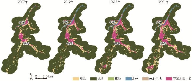
Taking Jingning County in Lishui City, Zhejiang Province as an example, this research uses the Markov Model to deduce the change of land use structure and the process of urban spatial growth from 2007 to 2021. By summarizing and analyzing the distribution location, green space form, and surrounding environment, the research identifies the unique types of public green spaces under this construction method. On this basis, in combination with the morphological spatial pattern analysis method and the connectivity index method, the research obtains the landscape connectivity of green space from 2012 to 2022. Moreover, the research also uses spatial syntax to obtain the accessibility of residents from 2012 to 2022. From the perspective of coordinating ecological connectivity with resident accessibility, the evolution law of public green space pattern in response to urban spatial growth is revealed, providing a theoretical basis for the positive “adaptive” layout of public green spaces.
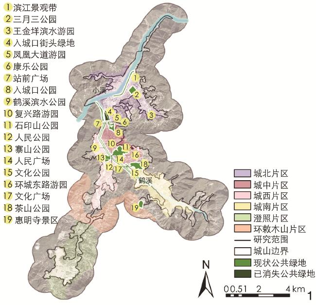
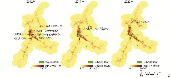
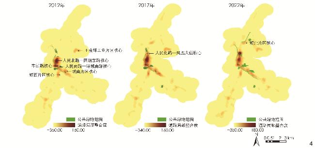
The research identifies the spatial growth mode of the built area in Jingning County that is featured by axial extension and finger-shaped expansion, as well as three unique types of public green spaces formed during this growth process, namely narrow green belt, sporadic regular green space, and irregular mountainous green space. The pattern evolution of public green space in Jingning County has resulted in three typical negative performance: 1) An increase in ecological space area without significant improvement in structural connectivity, and a decrease in functional connectivity; 2) a mismatch between the spatial distribution of green space and the “core” of accessibility (highly accessible areas); 3) poor local accessibility of linear green space.
Further research has found that at the level of landscape connectivity, the landscape connectivity of public green spaces is not related to the size of ecological space area, but is significantly and positively correlated with the proportion of their core ecological areas. The accessibility level of public green spaces is related to their own pattern characteristics and spatial distribution. With the construction and layout of public green spaces in Jingning and the improvement of surrounding road network, the phenomenon of “misalignment” between the highly accessible areas of urban roads and the layout of public green spaces has been alleviated to some extent. This research finally proposes several optimization strategies for public green spaces in mountainous towns that are under axial and finger-shaped spatial growth. At the level of landscape connectivity optimization, the research proposes to expand the core area within public green spaces; at the level of accessibility optimization, the research proposes a planning strategy for the highly accessible core layout of roads in nearby areas and the division of key construction sections for linear green spaces; additionally, the research also proposes the method for differentiated application of the aforesaid strategies in new and old urban areas, with a view to promoting the positive adaptation of public green spaces to the axial and finger-shaped spatial growth mode, and improving the ecosystem service functions of public green space while maintaining the characteristics of mountainous towns. This research reveals the positive and negative adaptation of public green spaces to urban spatial growth from the perspective of coordinating ecological connectivity with resident accessibility. As the mutual adaptation between subjects is influenced by local economic and cultural characteristics, future research may consider adding other response dimensions.
Mengting TANG , Yun ZHANG . The Pattern Evolution of Public Green Space in Mountainous Towns and Its Performance from the Perspective of Coordinating Ecological Connectivity with Residents’ Accessibility[J]. Landscape Architecture, 2024 , 31(7) : 93 -99 . DOI: 10.3724/j.fjyl.202309140420
表1 基础数据来源Tab. 1 Sources of basic data |
| 数据内容 | 空间分辨率 | 时间范围 | 数据来源 | 网址 |
| 土地覆盖数据 | 30 m×30 m | 2007—2021年 | 中国土地覆盖数据集(China Land Cover Dataset, CLCD) | www.globallandcover.com |
| 路网矢量数据 | 1∶2256 | 2022年 | 高德矢量街道图 | — |
| Google Earth影像 | 1∶2256 | 2012—2022年 | Google Earth | — |
| 哨兵-2卫星遥感影像 | 10 m×10 m | 2017—2022年 | 欧洲航天局 | europa.nasa.gov |
| 资源一号卫星遥感影像 | 10 m×10 m | 2012年 | 中国资源卫星应用中心 | www.cresda.com/zgzywxyyzx/index.html |
| 数字高程模型 | 12.5 m×12.5 m | 2008年 | 美国国家航空航天局 | www.nasa.gov |
表2 2007—2021年各类土地利用类型转移矩阵Tab. 2 Land use transfer matrix (2007 − 2021) |
| 2007年土地利用类型 | 2021年土地利用类型面积(转移占比)/hm2(%) | 总计/hm2 | ||||
| 草地 | 耕地 | 不透水面 | 林地 | 水域 | ||
| 草地 | 0.044 9 (2.36) | 0.987 6 (51.92) | 0.813 3 (42.75) | 0.056 6 (2.97) | 0 (0) | 1.90 |
| 耕地 | 2.413 6 (0.35) | 340.724 0 (49.93) | 224.490 0 (32.90) | 77.518 8 (11.36) | 37.307 6 (5.46) | 682.45 |
| 不透水面 | 0.000 7 (0) | 12.230 0 (3.87) | 270.747 0 (85.56) | 4.262 0 (1.35) | 29.186 9 (9.22) | 316.43 |
| 林地 | 4.026 2 (0.06) | 549.195 0 (7.71) | 169.867 0 (2.38) | 6394.359 9 (89.71) | 10.091 9 (0.14) | 7 127.54 |
| 水域 | 0 (0) | 2.180 3 (4.55) | 8.492 8 (17.72) | 3.812 4 (7.95) | 33.444 8 (69.78) | 47.93 |
表3 研究区新增公共绿地来源类型占比Tab. 3 Proportion of new sources of public green space in the research area |
| 城镇公共绿地类型 | 绿地来源 | |||
| 耕地 | 林地 | 水域 | 不透水面 | |
| 狭长绿带 | 15 | −37 | 3 | 119 |
| 零星规则绿地 | 44 | 18 | 0 | 38 |
| 不规则山体绿地 | 22 | 73 | 0 | 5 |
表4 2012—2022年研究区范围内绿地连通性水平Tab. 4 Connectivity level of green space within the research area (2012 − 2022) |
| 年份 | 各景观类型面积(占比)/hm2(%) | 生态空间总面积/hm2 | PC值 | ||||||
| 核心区 | 岛状斑块 | 孔隙 | 边缘区 | 桥接区 | 环道区 | 支线 | |||
| 2012 | 6221.70(90) | 29.44(0) | 256.25(4) | 229.66(3) | 34.76(1) | 65.83(1) | 56.14(1) | 6893.78 | 62 285 340 |
| 2017 | 6215.30(91) | 32.83(0) | 210.68(3) | 231.41(3) | 35.03(1) | 55.36(1) | 56.84(1) | 6837.45 | 60 083 870 |
| 2022 | 5980.96(89) | 45.94(1) | 218.32(3) | 301.45(4) | 50.54(1) | 60.66(1) | 77.98(1) | 6735.85 | 55 307 910 |
表5 2012—2022年公共绿地范围内绿地连通性水平Tab. 5 Connectivity level of public green space (2012 − 2022) |
| 年份 | 各景观类型占比/% | 生态空间 总面积/hm2 | PC值 | ||||||
| 核心区 | 岛状斑块 | 孔隙 | 边缘区 | 桥接区 | 环道区 | 支线 | |||
| 2012 | 28 | 27 | 1 | 16 | 11 | 0 | 17 | 21.5 | 146 867 |
| 2017 | 34 | 13 | 7 | 15 | 5 | 2 | 24 | 38.3 | 200 832 |
| 2022 | 30 | 29 | 2 | 19 | 6 | 1 | 13 | 61.5 | 181 760 |
表6 2022年各类公共绿地连通重要性水平Tab. 6 Connectivity importance level of various public green spaces in 2022 |
| 公共绿地类型 | 各景观类型占比/% | dPC均值 | ||||||
| 核心区 | 岛状斑块 | 孔隙 | 边缘区 | 桥接区 | 环道区 | 支线 | ||
| Ⅰ | 24 | 8 | 1 | 17 | 27 | 3 | 20 | 5.801 |
| Ⅱ | 19 | 4 | 0 | 29 | 29 | 1 | 18 | 0.001 |
| Ⅲ | 65 | 5 | 6 | 17 | 1 | 2 | 4 | 85.113 |
表7 2012—2022年各类公共绿地及道路整合度统计Tab. 7 Statistics on the integration of various public green spaces and roads (2012 − 2022) |
| 年份 | Ⅰ类绿地 整合度 | Ⅱ类绿地 整合度 | Ⅲ类绿地 整合度 | 公共绿地 整合度均值 | 前70%道路 整合度均值 | |||||||||
| 全局 | 局部 | 全局 | 局部 | 全局 | 局部 | 全局 | 局部 | 全局 | 局部 | |||||
| 2012 | 256.14 | 47.51 | 249.57 | 49.72 | 250.59 | 36.71 | 250.77 | 44.56 | 196.31 | 21.55 | ||||
| 2017 | 308.33 | 48.26 | 303.14 | 52.36 | 252.66 | 40.54 | 284.79 | 48.06 | 240.19 | 25.08 | ||||
| 2022 | 349.70 | 25.97 | 370.50 | 56.25 | 313.31 | 38.09 | 350.03 | 46.79 | 290.34 | 25.43 | ||||
图3 2012—2022年道路全局整合度核密度与公共绿地布局关系Fig. 3 Relationship between the global integration degree and kernel density of roads and the layout of public green spaces (2012−2022) |
文中图表均由作者绘制,
| [1] |
黄光宇. 山地城市空间结构的生态学思考[J]. 城市规划, 2005, 39(1): 57-63.
HUANG G Y. Ecological Thinking over Spatial Structure of Hilly City[J]. City Planning Review, 2005, 39(1): 57-63.
|
| [2] |
刘骏. 山地城市绿地系统规划问题及对策研究[J]. 中国园林, 2017, 33(9): 67-71.
LIU J. Study on the Problems and Countermeasures of the Urban Green Space System Planning in Mountain City[J]. Chinese Landscape Architecture, 2017, 33(9): 67-71.
|
| [3] |
FORMAN R T T. Land Mosaics[M]. Cambridge: Cambridge University Press, 1995.
|
| [4] |
李慧, 李丽, 吴巩胜, 等. 基于电路理论的滇金丝猴生境景观连通性分析[J]. 生态学报, 2018, 38(6): 2221-2228.
LI H, LI L, WU G S, et al. Analysis of the Landscape-Level Connectivity of the Yunnan Sub-nosed Monkey Habitat Based on Circuit Theory[J]. Acta Ecologica Sinica, 2018, 38(6): 2221-2228.
|
| [5] |
罗言云, 李春容, 谢于松, 等. 成都市中心城区城市公园景观连通性[J]. 生态学杂志, 2020, 39(11): 3795-3807.
LUO Y Y, LI C R, XIE Y S, et al. Landscape Connectivity of Urban Parks in the Downtown of Chengdu[J]. Chinese Journal of Ecology, 2020, 39(11): 3795-3807.
|
| [6] |
屠星月, 黄甘霖, 邬建国. 城市绿地可达性和居民福祉关系研究综述[J]. 生态学报, 2019, 39(2): 421-431.
TU X Y, HUANG G L, WU J G. Review of the Relationship Between Urban Greenspace Accessibility and Human Well-Being[J]. Acta Ecologica Sinica, 2019, 39(2): 421-431.
|
| [7] |
王子琳, 李志刚, 程晗蓓. 中国大城市公园绿地可达性的公平性研究: 以武汉市中心城区为例[J]. 地理科学进展, 2022, 41(4): 621-635.
WANG Z L, LI Z G, CHENG H B. The Equity of Urban Park Green Space Accessibility in Large Chinese Cities: A Case Study of Wuhan City[J]. Progress in Geography, 2022, 41(4): 621-635.
|
| [8] |
黄思颖, 徐伟振, 傅伟聪, 等. 城市公园绿地可达性及其提升策略研究[J]. 林业经济问题, 2022, 42(1): 89-96.
HUANG S Y, XU W Z, FU W C, et al. Study on the Accessibility of Urban Park Green Space and Its Promotion Strategy[J]. Issues of Forestry Economics, 2022, 42(1): 89-96.
|
| [9] |
戴晓玲, 于文波. 空间句法自然出行原则在中国语境下的探索: 作为决策模型的空间句法街道网络建模方法[J]. 现代城市研究, 2015(4): 118-125.
DAI X L, YU W B. Exploration of Natural Movement Principle of Space Syntax in Chinese Context: The Discussion of Construction Method of Space Syntax Street Network Models a Strategic Model[J]. Modern Urban Research, 2015(4): 118-125.
|
| [10] |
刘淑燕, 余新晓, 李庆云, 等. 基于CA-Markov模型的黄土丘陵区土地利用变化[J]. 农业工程学报, 2010, 26(11): 297-303.
LIU S Y, YU X X, LI Q Y, et al. Land Use Change in Loess Hilly Region Based on CA-Markov Model[J]. Transactions of the Chinese Society of Agricultural Engineering, 2010, 26(11): 297-303.
|
| [11] |
YANG J , HUANG X. The 30 m Annual Land Cover Dataset and Its Dynamics in China from 1990 to 2019[J]. Earth System Science Data, 2021, 13(8): 3907-3925.
|
| [12] |
牛星, 欧名豪. 基于MARKOV理论的扬州市土地利用结构预测[J]. 经济地理, 2007, 27(1): 153-156.
NIU X, OU M H. Study on the Forecast of Land Structure in Yangzhou City Based on Markov Theory[J]. Economic Geography, 2007, 27(1): 153-156.
|
| [13] |
陈思清, 汪洁琼, 王南. 融合景观连通性的城镇规划与生物多样性生态服务效能优化[J]. 风景园林, 2017, 24(1): 66-81.
CHEN S Q, WANG J Q, WANG N. Integrating Landscape Connectivity into Town Planning for Biodiversity Ecosystem Service Provision[J]. Landscape Architecture, 2017, 24(1): 66-81.
|
| [14] |
于亚平, 尹海伟, 孔繁花, 等. 基于MSPA的南京市绿色基础设施网络格局时空变化分析[J]. 生态学杂志, 2016, 35(6): 1608-1616.
YU Y P, YIN H W, KONG F H, et al. Analysis of the Temporal and Spatial Pattern of the Green Infrastructure Network in Nanjing Based on MSPA[J]. Chinese Journal of Ecology, 2016, 35(6): 1608-1616.
|
| [15] |
陈怡欣, 莫登奎, 严恩萍. 基于Sentinel-2的复杂山区常用植被指数地形效应分析[J]. 生态学杂志, 2022, 42(4): 956-965.
CHEN Y X, MO D K, YAN E P. Analysis on Topographic Effects of Commonly Used Vegetation Indices in Complex Mountain Area Based on Sentinel-2 Data[J]. Chinese Journal of Ecology, 2022, 42(4): 956-965.
|
| [16] |
FORMAN R T T. Landscape Ecology[M]. New York: John Wiley & Sons, 1986.
|
| [17] |
熊春妮, 魏虹, 兰明娟. 重庆市都市区绿地景观的连通性[J]. 生态学报, 2008(5): 2237-2244.
XIONG C N, WEI H, LAN M J. Analysis of Connectivity on Greenland Landscape in Metropolitan Region of Chongqing City[J]. Acta Ecologica Sinica, 2008(5): 2237-2244.
|
| [18] |
刘常富, 周彬, 何兴元, 等. 沈阳城市森林景观连接度距离阈值选择[J]. 应用生态学报, 2010, 21(10): 2508-2516.
LIU C F, ZHOU B, HE X Y, et al. Selection of Distance Thresholds of Urban Forest Landscape Connectivity in Shenyang City[J]. Chinese Journal of Applied Ecology, 2010, 21(10): 2508-2516.
|
| [19] |
文宁. 空间句法中轴线模型与线段模型在城市设计应用中的区别[J]. 城市建筑, 2019, 16(4): 9-12.
WEN N. The Difference Between Axis Model and Segment Model in Space Syntax in Urban Design Application[J]. Urbanism and Architecture, 2019, 16(4): 9-12.
|
| [20] |
付磊, 贺旺, 刘畅. 山地带形城市的空间结构与绩效[J]. 城市规划学刊, 2012(S1): 18-22.
FU L, HE W, LIU C. The Spatial Structure and Performance of Mountainous Linear City[J]. Urban Planning Forum, 2012(S1): 18-22.
|
| [21] |
王天一, 田国行. 河南平原地区典型小城镇绿地布局结构特征[J]. 林业科技开发, 2013, 27(1): 129-133.
WANG T Y, TIAN G H. Characteristics of Green Space Layout Structure in Typical Small Towns in Henan Plain Area[J]. Journal of Forestry Engineering, 2013, 27(1): 129-133.
|
/
| 〈 |
|
〉 |