
Research on the Walking Accessibility Attenuation of Green Open Space in Mountainous Cities Based on Web Map Path Tracking
|
LUO Dan, Ph.D., is an associate professor in and deputy director of the Faculty of Architecture and Urban Planning, Chongqing University, and a contributing editor of this journal. His research focuses on landscape planning and design |
|
ZHANG Yishan is a master student in the Faculty of Architecture and Urban Planning, Chongqing University. Her research focuses on landscape planning and design |
|
HONG Jingke, Ph.D., is a professor in the School of Management Science and Real Estate, Chongqing University. His research focuses on urban complex system analysis and modeling, and urban resource management and policy research |
Received date: 2023-07-09
Revised date: 2024-05-20
Online published: 2025-12-17
Copyright
Green open space serves as a main carrier for daily leisure and entertainment of urban residents, and is closely related to the construction of urban livable environment and the improvement of residents’ quality of life. However, in mountain cities with unique urban texture and spatial pattern due to the restriction of such factors as landform and construction conditions, the walking system is closely integrated with the undulating terrain, posing many challenges to the planning and construction of green open space. For mountain cities, the walking accessibility is relatively limited, the actual walking accessibility of green open space is inferior to the theoretical accessibility, and the traditional methods for accessibility measurement may not take effect, resulting in the lack of green open space in the real life of residents. In view of this, it is necessary to improve the accuracy of quantitative evaluation of accessibility in mountain cities. In fact, accurately and objectively measuring the walking accessibility of urban green open space and revealing the difference between actual accessibility and theoretical accessibility are the key to optimizing and improving the service capability of green open space in mountainous areas.
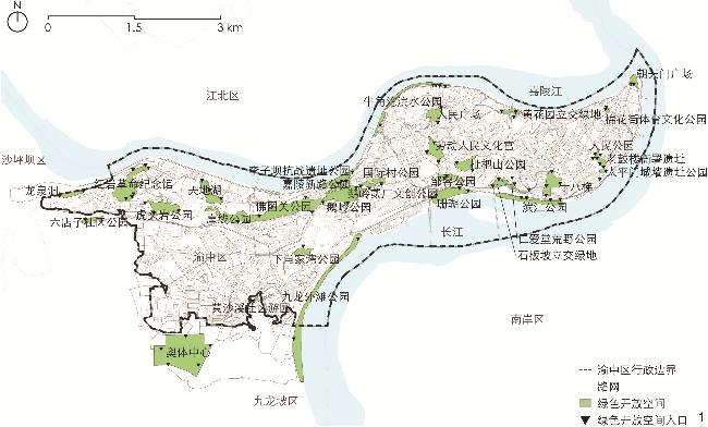
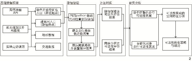
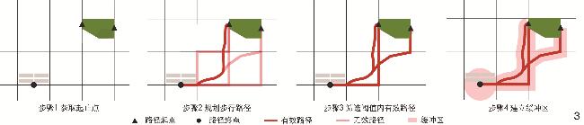
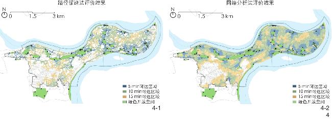
Taking Yuzhong District in Chongqing as an example, this research, based on ArcGIS platform and Amap application programming interface (API), develops a new quantitative accessibility evaluation method termed “path tracking method” with reference to the path buffer method proposed by previous scholars. Then the research compares the evaluation results of the path tracking method and the network analysis method to differentially identify the areas with accessibility attenuation, which helps more clearly and accurately reflect the spatial problems under the influence of mountain conditions. After that, the research discusses the gap between the theoretical and practical use of green open space. Specifically, the path tracking method uses python-based self-programmed code to obtain the walking path trajectory data from the green open space entrance to the building entrance in batches, unify the geographical coordinate system and carry out visual analysis, set the buffer range at both sides and end point of the path as 10 meters and 30 meters respectively, and obtain the accessible range of 5, 10 and 15 minutes.
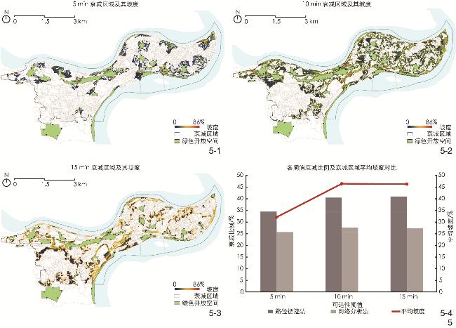
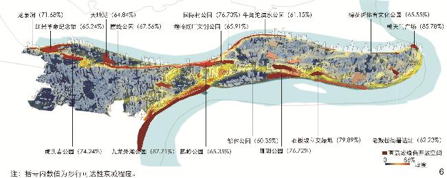
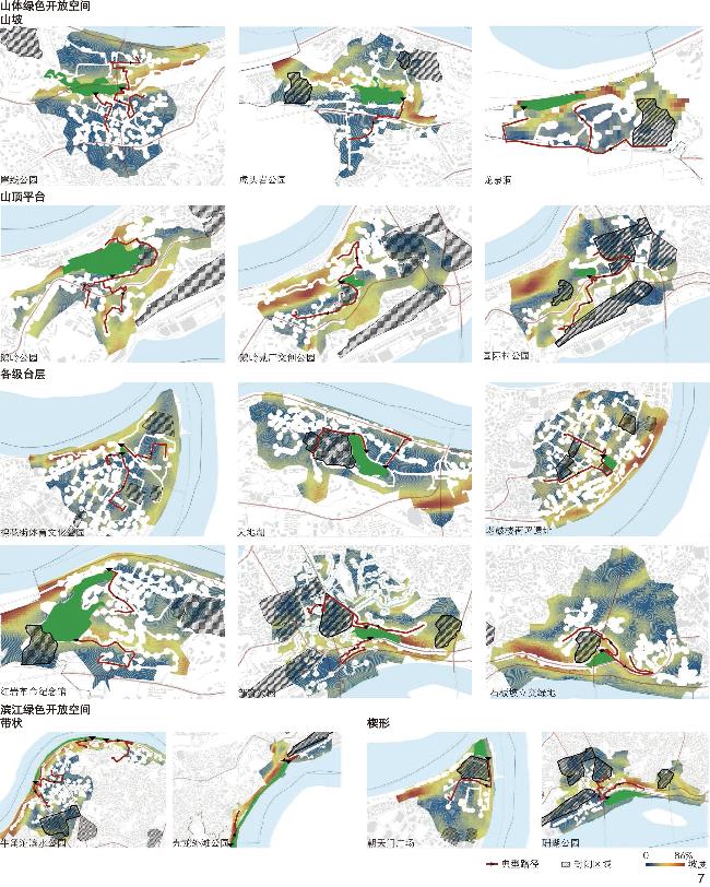
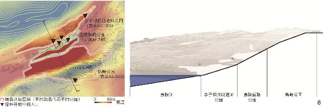
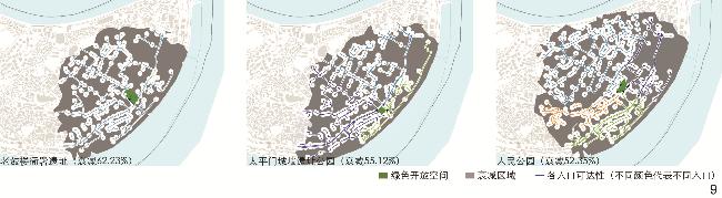
The walkability evaluation results of green open space in Yuzhong District show that: 1) The evaluation results of the two methods reflect similar spatial distribution, that is, there exist large-sized service blind areas in the southwest and the periphery of Yuzhong District; 2) comparing the evaluation results of the two methods, it is found that the walkability of green space in Yuzhong District decreases by 43.19%, and the accessibility attenuation areas within the threshold of 5 minutes, 10 minutes and 15 minutes account for 32.12%, 46.49% and 46.30%, respectively; 3) the longer the actual walking distance, the greater the attenuation of accessibility; the attenuation area within the 5 min threshold is mostly located at the entrance of green open space and complex three-dimensional traffic area, and the attenuation area within the 10/15 min threshold is mostly distributed along the terrain or road trend; the insufficient pedestrian permeability of blocks may also lead to the attenuation of accessibility; 4) the accessibility attenuation varies among different research objects, of which 16 objects have an attenuation degree greater than 60%, and Kowloon Bund Park has the largest attenuation degree with an attenuation ratio of 87.71%; 5) in order to further analyze the correlation between mountain spatial characteristics and accessibility attenuation, the green open spaces are divided into five types according to their geographical locations, among which the hilltop, platform-based and riverside wedge-shaped green open spaces have a higher degree of attenuation; 6) factors affecting the accessibility attenuation of green open space in mountain cities include location factors, environmental factors and ontology factors.
Finally, based on the above analysis, the research puts forward optimization suggestions for the planning and construction of green open space in mountain cities from the perspective of walking accessibility. These suggestions include increasing the total amount and service efficiency of green open spaces by siting them on the mountain, connecting different vertical levels of green open space through the slow walking system, and guiding residents to visit green open space through the permeability of the interface thereof. This research provides an objective method for evaluating the walkability of green open space in mountain cities, with the evaluation results being more in line with the actual situation compared with other relevant methods, and points out the shortcomings of existing methods and indicators, which has important practical significance for improving the service efficiency of green open space in mountain cities. Meanwhile, the individual subjective factors of residents and the attractiveness of green open space can be further considered in future research, and the evaluation method and influence mechanism of multi-dimensional accessibility can be further explored, so as to provide scientific basis for the evaluation of mountainous urban space and reference for the future planning and construction of mountainous urban space.
Dan LUO , Yishan ZHANG , Jingke HONG . Research on the Walking Accessibility Attenuation of Green Open Space in Mountainous Cities Based on Web Map Path Tracking[J]. Landscape Architecture, 2024 , 31(7) : 100 -107 . DOI: 10.3724/j.fjyl.202307090309
表1 研究方法特征及对照Tab. 1 Characteristics of and comparison between different research methods |
| 评价方法 | 特征 | 方法示意 | 实例 |
| 路径循迹法 | 从路径出发,更符合实际步行轨迹;绕行过街设施或山体、等待交通信号灯等均产生步行阻力;按实际情况设置路径缓冲,能够适应山地条件下低渗透性的城市形态 | ① | ③ |
| 网络分析法 | 从路网出发,模拟理论可达范围;以水平方向的时间、距离设置阻抗;不考虑道路两侧的用地性质及渗透性 | ② | ④ |
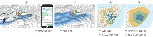 | |||
表2 数据来源Tab. 2 Data source |
| 数据类别 | 数据来源 | 备注 |
| 路径起止点数据 | 结合2021年重庆市渝中区用地规划公开图纸(从重庆市渝中区人民政府官方网站获取),检索高德地图API的POI类型,抓取绿色开放空间和建筑相关数据,建立作为路径起点的绿色开放空间出入口点数据集和作为路径终点的建筑出入口点数据集 | 经过实地走访调研再次纠正、确认起止点,属性包括名称、类型、形状、面积、出入口位置等 |
| 步行路径数据 | 在获取有效步行路径点集后,统一数据的地理坐标系并投影,通过ArcGIS中的点集转线工具获取所有步行路径并连接相关数据 | 属性包括坐标、消耗时间与实际步行距离 |
| 交通数据 | 通过高德地图API获取各类路网数据,包括省道、城市一级道路、支路、其他道路及人行道路等,结合路径补充步行道路,以道路中心线建立拓扑网络 | 属性包括名称、长度 |
| 地形数据 | 数字高程模型(digital elevation model, DEM)数据通过地理空间数据云平台(www.gscloud.cn)获取 | 采用ArcGIS平台进行数据处理并提取坡度信息 |
表3 渝中区绿色开放空间分类Tab. 3 Classification of green open spaces in Yuzhong District |
| 环境 | 类型 | 高衰减区域(典型对象) | 非高衰减区域 | 典型对象数量 占比/% |
| 山体 | 山坡 | 崖线公园、虎头岩公园、龙泉洞 | 人民公园、十八梯、仁爱堂荒野公园、佛图关公园、下肖家湾公园、嘉陵新路公园 | 33 |
| 山顶平台 | 鹅岭公园、鹅岭贰厂文创公园、国际村公园 | 枇杷山公园 | 75 | |
| 各级台层 | 棉花街体育文化公园、天地湖、老鼓楼衙署遗址、红岩革命纪念馆、邹容公园、石板坡立交绿地 | 太平门城墙遗址公园、人民广场、黄花园立交绿地、劳动人民文化宫 | 60 | |
| 滨江 | 带状 | 牛角沱滨水公园、九龙外滩公园 | 李子坝抗战遗址公园、滨江公园 | 50 |
| 楔形 | 朝天门广场、珊瑚公园 | 100 |
| [1] |
KHAN M W, HOSSAIN M S, ALAM M. GIS-Based Analysis to Identify the Distribution and Accessibility of Urban Green Space in Dhaka Metropolitan City, Bangladesh[J]. Geographic Information System, 2023, 15(1): 35-52.
|
| [2] |
SCHNELL N M D. The Benefits of Discrete Visits in Urban Parks[J]. Urban Forestry & Urban Greening, 2019, 41: 179-184.
|
| [3] |
DAI D. Racial/Ethnic and Socioeconomic Disparities in Urban Green Space Accessibility: Where to Intervene?[J]. Landscape & Urban Planning, 2011, 102(4): 234-244.
|
| [4] |
秦华, 高骆秋. 基于GIS-网络分析的山地城市公园空间可达性研究[J]. 中国园林, 2012, 28(5): 47-50.
QIN H, GAO L Q. Research of the Accessibility of Mountainous Urban Park Based on GIS and Network Analysis[J]. Chinese Landscape Architecture, 2012, 28(5): 47-50.
|
| [5] |
MRAK I. The Walkability of a City with Difficult Terrain: Evaluation of Barriers to Use of Spatial Qualities for Users and Main Guidelines for Improvement[M]// TIRA M, PEZZAGNO M, RICHIEDEI A. Pedestrians, Urban Spaces and Health. London: CRC Press, 2020: 69-73.
|
| [6] |
黄瓴, 明峻宇, 赵畅, 等. 山地城市社区生活圈特征识别与规划策略[J]. 规划师, 2019, 35(3): 11-17.
HUANG L, MING J Y, ZHAO C, et al. The Character Analysis and Planning Strategy of Community Life Circle in Mountainous Cities[J]. Planners, 2019, 35(3): 11-17.
|
| [7] |
吴丹旎, 王中德. 探析山地城市步行系统的建构: 以重庆渝中区山城步道为例[J]. 城市住宅, 2020, 27(6): 103-105.
WU D N, WANG Z D. Exploration on the Construction of Walking System in Mountainous City: Taking the Mountain Trail in Yuzhong District, Chongqing as an Example[J]. City & House, 2020, 27(6): 103-105.
|
| [8] |
王兰.山地城市公园可达性研究: 以重庆市主城区山地城市公园为例[D].重庆: 西南大学, 2008.
WANG L. Research on Accessibility of Park in the Mountainous Urban Areas: A Case Study on the Parks of Mountain Urban Areas in Main District of Chongqing[D]. Chongqing: Southwest University, 2008.
|
| [9] |
戚荣昊, 杨航, 王思玲, 等. 基于百度POI数据的城市公园绿地评估与规划研究[J]. 中国园林, 2018, 34(3): 32-37.
QI R H, YANG H, WANG S L, et al. Study on Evaluation and Planning of Urban Parks Based on Baidu POI Data[J]. Chinese Landscape Architecture, 2018, 34(3): 32-37.
|
| [10] |
OLIVER L N, SCHUURMAN N, HALL A W. Comparing Circular and Network Buffers to Examine the Influence of Land Use on Walking for Leisure and Errands[J]. International Journal of Health Geographics, 2007, 6: 41.
|
| [11] |
FRANCISCO A U, BEVERLY S, GAVIN M, et al. Walkability Makeover for Suburbia: Retrofitting Calgary’s Suburbs, an Economic Evaluation (Breakout Presentation)[J]. Journal of Transport & Health, 2017, 7: S55.
|
| [12] |
朱涛, 何奥, 杨滨源. 基于真实路径的山地社区步行可达性评估研究: 以重庆阳光社区为例[J]. 城市建筑空间, 2022, 29(7): 93-96.
ZHU T, HE A, YANG B Y. Evaluation of Walking Accessibility in Mountainous Communities Based on Real Path: A Case Study of Yangguang Community in Chongqing[J]. Urban Architecture Space, 2022, 29(7): 93-96.
|
| [13] |
廖心治, 王华, 赵万民. 融合地图数据的山地城市医疗设施服务覆盖评估方法研究[J]. 地球信息科学学报, 2021, 23(4): 604-616.
LIAO X Z, WANG H, ZHAO W M. Evaluation Method of Medical Facilities Service Coverage in Mountainous Cities Based on Map Data[J]. Journal of Geo-information Science, 2021, 23(4): 604-616.
|
| [14] |
重庆市渝中区人民政府.自然地理: 渝中: 主城之中[EB/OL].(2022-01-01)[2023-04-01]. http://www.cqyz.gov.cn/zjyz/yzgk/zrdl/202302/t20230223_11646635.html.
People’s Government of Chongqing, Yuzhong District. Natural Geography: Yuzhong District: The Center of the Main City[EB/OL]. (2022-01-01)[2023-04-01]. http://www.cqyz.gov.cn/zjyz/yzgk/zrdl/202302/t20230223_11646635.html.
|
| [15] |
李梦一欣, 黄琦, 舍费尔. 德国城市绿色开放空间结构质性分析方法[J]. 风景园林, 2022, 29(12): 12-19.
LI M Y X, HUANG Q, SCHAFER J. Qualitative Analytical Method for Urban Green Open Space Structure in Germany[J]. Landscape Architecture, 2022, 29(12): 12-19.
|
| [16] |
中华人民共和国住房和城乡建设部.城市绿地规划标准: GB/T 51346-2019[S].北京: 中国建筑工业出版社, 2019.
Ministry of Housing and Urban-Rural Development of the People’s Republic of China. Standard for Planning Urban Green Space: GB/T 51346-2019 [S]. Beijing: China Architecture & Building Press, 2019.
|
| [17] |
林同棪国际工程咨询(中国)有限公司.城市道路交通规划及路线设计标准: DBJ50/T-064-2022[S].重庆: 重庆市住房和城乡建设委员会, 2022.
T Y Lin International Engineering Consulting (China) Co., Ltd. Code for Traffic Plan and Route Design of Urban Roads: DBJ50/T-064-2022[S]. Chongqing: Chongqing Housing and Urban Rural Construction Commission, 2022.
|
| [18] |
WILLBERG E, FINK C, TOIVONEN T. The 15-Minute City for All?: Measuring Individual and Temporal Variations in Walking Accessibility[J]. Journal of Transport Geography, 2023, 106: 103521.
|
| [19] |
肖作鹏, 韩来伟, 柴彦威. 生活圈规划嵌入国土空间规划的思考[J]. 规划师, 2022, 38(9): 145-151.
XIAO Z P, HAN L W, CHAI Y W. Review on Embedding Life Cycle Planning in Territorial Space Planning System[J]. Planners, 2022, 38(9): 145-151.
|
| [20] |
黄思颖, 徐伟振, 傅伟聪, 等. 城市公园绿地可达性及其提升策略研究[J]. 林业经济问题, 2022, 42(1): 89-96.
HUANG S Y, XU W Z, FU W C, et al. Study on the Accessibility and Promotion Strategy of Urban Park Green Space[J]. Issues of Forestry Economics, 2022, 42(1): 89-96.
|
| [21] |
张婧远, 陈培育. 面向城市公园的感知可达性研究进展述评与人本规划思潮下的应用启示[J]. 国际城市规划, 2021, 36(5): 96-103.
ZHANG J Y, CHEN P Y. Reviewing the Research Development of Perceived Accessibility to Urban Parks and Its Application Inspirations in the Trend of Human-Oriented Planning[J]. Urban Planning International, 2021, 36(5): 96-103.
|
/
| 〈 |
|
〉 |