
Identification of Potential Distribution Areas of Rice-Growing Cultural Landscape in the Han River Basin
|
CHEN Siyu gained her master degree in Huazhong Agricultural University, and is an assistant in the Department of Digital Media, Software Engineering Institute of Guangzhou. Her research focuses on landscape planning and design, theory of landscape architecture, and protection of landscape architecture heritage |
|
WANG Le, Ph.D., is an associate professor in the College of Horticulture & Forestry Sciences of Huazhong Agricultural University, and a member of the Key Laboratory of Urban Agriculture in Central China, Ministry of Agriculture and Rural Affairs. Her research focuses on landscape planning and design, theory of landscape architecture, and protection of landscape architecture heritage |
Received date: 2024-04-01
Revised date: 2024-10-21
Online published: 2025-12-16
Copyright
Under the background of the rural revitalization strategy, it is very important to explore and protect agricultural landscape. Agricultural landscape is a kind of cultural landscape featuring continuous evolution and mutual adaptation between farming activities and natural geographical environment. The rice-growing cultural landscape is a kind of agricultural landscape that is rooted in the rice-growing agricultural production activities and demonstrates a harmonious symbiotic relationship with nature. This research aims to improve and break through the previous approach of using geographical environmental factors as the basis and method for spatial distribution identification. This approach incorporates considerations on the impact of farming cultural activities on the environment, and aims to provide reference for the identification, survey and management of potential cultural landscape.
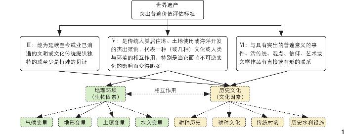
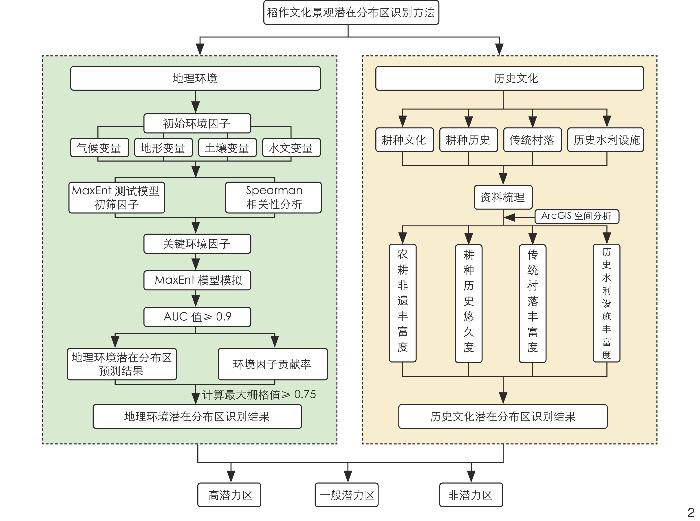
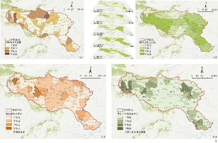
This research screens identification factors based on the OUV (outstanding universal value) evaluation criteria for agricultural landscapes. In combination with the biological and cultural characteristics of the rice-growing cultural landscape included in the the World Heritage List and the listed important rice-growing agricultural heritages in China, a method for identifying the potential distribution areas of rice-growing cultural landscape is developed at the county level from the perspectives of geographical environment (biological factors) and historical culture (cultural factors). The geographical environment identification factors are climate, topography, soil and hydrology, and the maximum entropy model is used for simulation of these factors; the historical and cultural identification factors are farming history, farming culture, traditional villages and historical water conservancy facilities, and ArcGIS is used for overlay analysis of these factors.
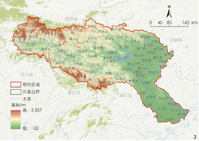
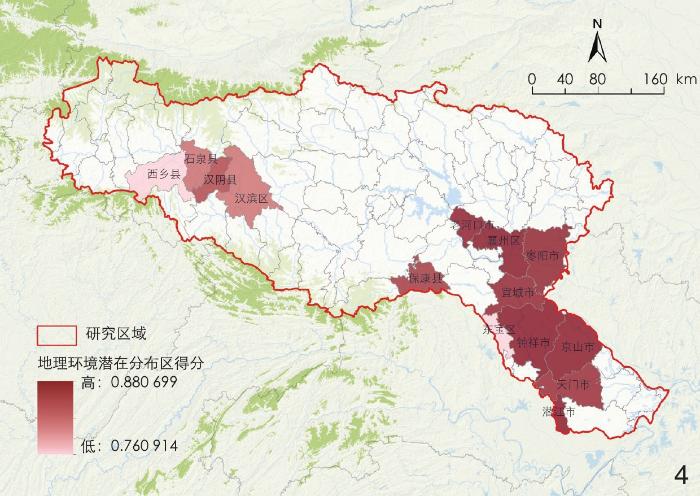
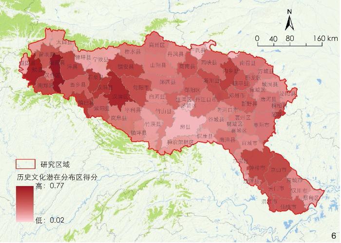
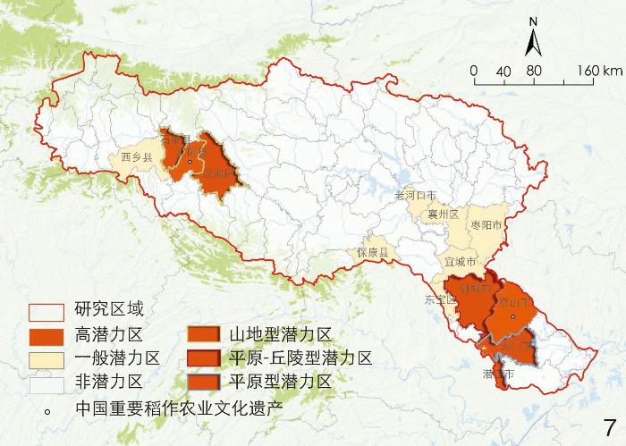
Most areas of the Han River Basin have terrain and climate conditions suitable for rice growth, and have abundant water resources suitable for paddy field irrigation. In addition, the Han River Basin has rich historical and cultural value of rice farming, where Neolithic rice-growing relics have been discovered. As a major north-south transportation route, the Han River Basin has witnessed frequent population migration activities, which have promoted agricultural exchanges between the north and south regions of China and also the spread of rice culture. The identification results show that from the perspectiove of geographical environment, there are potential distribution areas of rice-growing cultural landscape in the upper, middle and lower reaches of the Han River. Soil type, annual precipitation, precipitation in the driest month and elevation are the main environmental factors affecting the distribution of rice-growing agricultural cultural heritage. In terms of history and culture, the overall scores of the upper and lower reaches of the Han River are relatively high, and the area with the highest score is Chenggu County in Hanzhong City. In terms of the distribution of rice-growing cultural landscape, high-potential areas are those with high scores in both geographical environment and historical culture, distributed in Hanbin District, Shiquan County, and Hanyin County in Ankang City in the upper reaches of the river, and Jingshan, Zhongxiang, Tianmen and Qianjiang in the lower reaches, with Hanyin County and Jingshan City serving as home to important rice-growing cultural landscapes in China; general potential areas are those with a score greater than 0.75 in geographical environment while a lower score in historical culture, including Xixiang County in Hanzhong City, Laohekou City, Zaoyang City, Yicheng City, Xiangzhou District, Baokang County in Xiangyang City, and Dongbao District in Jingmen City; other districts and counties with a score below 0.75 in geographical environment are considered non-potential areas. In order to clarify the biocultural characteristics of high-potential areas, the research extracts the scores of each factor and divides the high-potential rice-growing agricultural landscape in the Han River Basin into such types as mountainous, plain-hilly, and plain rice-growing cultural landscape by combining topographic and geomorphic characteristics. Different landscape types form the cultural landscape patterns of “mountain – forest – village – farmland”, “valley – slope – farmland – village”, and “lake – embankment – farmland – village”.
It is found that the rice-growing cultural landscape is a complete system of change due to the comprehensive influence of geographical environment and historical culture factors. This research identifies potential distribution areas of rice-growing cultural landscape from the perspective of bio-cultural integration. This method is helpful to judge the background resource condition of the rice-growing cultural landscape from the regional level, and promote the protection and sustainable development of the cultural landscape in the basin.
CHEN Siyu , WANG Le . Identification of Potential Distribution Areas of Rice-Growing Cultural Landscape in the Han River Basin[J]. Landscape Architecture, 2024 , 31(12) : 57 -64 . DOI: 10.3724/j.fjyl.202404010194
表1 模型预测准确度评定标准Tab. 1 Evaluation criteria for model prediction accuracy |
| AUC值 | 评定标准 |
| [0.5~0.7) | 预测能力一般 |
| [0.7~0.9) | 预测能力较好 |
| [0.9~1.0) | 预测能力极好 |
表2 历史文化潜在分布区指标体系Tab. 2 Index system for potential distribution areas in terms of historical culture |
表3 关键环境因子Tab. 3 Key environmental factors |
| 环境 变量 | 识别的关键环境因子 |
| 气候 | 年平均温度、温度年际变化范围、最热季度的平均温度、年降水量、最干月降水量、降水量季节性变化量 |
| 地形 | 高程、地貌类型 |
| 土壤 | 土壤类型 |
| 水文 | 水系缓冲区(半径为5 、10 、15 、20 、25 km) |
表4 各个高潜力区得分Tab. 4 Scores for high-potential areas |
| 区县 | 总分 | 地理 环境 | 历史文化 | |||
| 耕种 历史 | 耕种 文化 | 传统 村落 | 历史水 利设施 | |||
| 汉滨区 | 0.64 | 0.81 | 0.80 | 0.00 | 0.81 | 0.30 |
| 石泉县 | 0.61 | 0.81 | 1.00 | 0.25 | 0.25 | 0.15 |
| 钟祥市 | 0.62 | 0.88 | 0.80 | 0.00 | 0.38 | 0.26 |
| 天门市 | 0.58 | 0.86 | 0.60 | 0.25 | 0.00 | 0.37 |
| 潜江市 | 0.58 | 0.87 | 0.60 | 0.25 | 0.00 | 0.41 |
文中图表均作者绘制,其中
| [1] |
韩锋. 文化景观: 填补自然和文化之间的空白[J].中国园林, 2010, 26(9): 7-11
HAN F. Cultural Landscape: Filling the Gaps between Nature and Culture[J]. Chinese Landscape Architecture, 2010, 26(9): 7-11.
|
| [2] |
ESCO World Heritage Centre. Operational Guidelines for the Implementation of the World Heritage Convention[EB/OL]. (2021) [2024-10-18]. https://whc.unesco.org/en/guidelines/.
|
| [3] |
王长松, 何雨, 王亚男, 等. 北京西山文化景观的形成与演变研究[J]. 城市发展研究, 2021, 28 (2): 66-73
WANG C S, HE Y, WANG Y N, et al. The Formation and Evolution of Xishan Cultural Landscape in Beijing[J]. Urban Development Studies, 2021, 28 (2): 66-73
|
| [4] |
WANG W H, LU Z X, ZHANG Z T, et al. Buddhist Heritage Landscape Evolution of Mount Wutai: A Path Dependence Approach[J]. Landscape Research, 2024, 49 (4): 527-539
|
| [5] |
朱正斌, 李瑞, 殷红梅, 等. 旅游驱动下传统民族村寨文化景观演化特征与机理研究: 基于贵州西江苗寨的案例[J]. 资源开发与市场, 2024, 40 (1): 152-160
ZHU Z B, LI R, YING H M, et al. Study on the Evolution Characteristics and Mechanism of Traditional Ethnic Village Cultural Landscape Driven by Tourism: Based on the Case of Xijiang Miao Village in Guizhou[J]. Resource Development & Market, 2024, 40 (1): 152-160
|
| [6] |
毕雪婷, 韩锋. 文化景观价值的解读方式研究[J]. 风景园林, 2017, 24 (7): 100-107
BI X T, HAN F. Study on the Ways to Interpret the Cultural Landscape Values[J]. Landscape Architecture, 2017, 24 (7): 100-107.
|
| [7] |
涂宇倩, 张婧雅. 层积视角下武夷山国家公园文化景观特征识别[J]. 风景园林, 2024, 31 (1): 71-79
TU Y Q, ZHANG J Y. Identification of Characters of Cultural Landscape in Wuyishan National Park from the Perspective of Stratification[J]. Landscape Architecture, 2024, 31 (1): 71-79
|
| [8] |
CAO K R, LIU Y, CAO Y H, et al. Construction and Characteristic Analysis of Landscape Gene Maps of Traditional Villages Along Ancient Qin-Shu Roads, Western China[J/OL]. Heritage Science: 1-20[2024-01-20]. https://link.springer.com/content/pdf/10.1186/s40494-024-01155-y.pdf.
|
| [9] |
谢雨婷, 诺尔夫. 长三角大都市区文化景观特征评估[J]. 中国园林, 2020, 36 (12): 73-78
XIE Y T, NOLF C. Cultural Landscape Characterization in the Metropolitan Areas of the Yangtze River Delta[J]. Chinese Landscape Architecture, 2020, 36 (12): 73-78.
|
| [10] |
SUN Y, OU Q F. Research on the Traditional Zoning, Evolution, and Integrated Conservation of Village Cultural Landscapes Based on “Production-Living-Ecology Spaces”: A Case Study of Villages in Meicheng, Guangdong, China[J]. Open Geosciences, 2021, 13 (1): 1303-1317
|
| [11] |
吴屹豪, 刘阳, 高璟. 基于活态遗产保护的田园综合体生态构建路径: 以云南景迈山古茶林文化景观申遗示范区为例[J]. 中国园林, 2023, 39 (12): 67-73
WU Y H, LIU Y, GAO J. Ecological Construction Path of Rural Complex Based on Living Heritage Protection: Taking the Ancient Tea Grove Cultural Landscape of Jingmai Mountain as an Example[J]. Chinese Landscape Architecture, 2023, 39 (12): 67-73.
|
| [12] |
XIA Y. Research on The Integration of Regional Cultural Landscape and Ecotourism Planning[J]. Fresenius Environmental Bulletin, 2020, 29 (7A): 5996-6005.
|
| [13] |
SHEN J, CHOU R J. Cultural Landscape Development Integrated with Rural Revitalization: A Case Study of Songkou Ancient Town[J]. Land, 2021, 10 (4): 406.
|
| [14] |
王璐, 钟宏伟, 毛世红. 基于AHP的茶文化景观旅游开发潜力评价: 以龙脊茶文化景观为例[J]. 衡阳师范学院学报, 2023, 44 (6): 114-120
WANG L, ZHONG H W, MAO S H. Evaluation of the Development Potential of Tea Culture Landscape Tourism Based on AHP: Taking Longji Tea Culture Landscape as an Example[J]. Journal of Hengyang Normal University, 2023, 44 (6): 114-120
|
| [15] |
ICOMOS. Connecting Practice: A Commentary on Nature-Culture Keywords[EB/OL]. (2023)[2024-01-18]. https://openarchive.icomos.org/id/eprint/2555/1/CP-Commentary-on-Keywords.pdf.
|
| [16] |
闵庆文, 张永勋. 农业文化遗产与农业类文化景观遗产比较研究[J]. 中国农业大学学报(社会科学版), 2016, 33 (2): 119-126
MIN Q W, ZHANG Y X. Comparison Between Agri-cultural Heritage Systems and Agri-cultural Landscape[J]. Journal of China Agricultural University (Social Sciences), 2016, 33 (2): 119-126.
|
| [17] |
蒋茜, 邱新法, 李爽爽, 等. 基于GridMet模型的浙江省水稻种植适宜性区划分析[J]. 科学技术与工程, 2020, 20 (11): 4256-4263
JIANG X, QIU X F, LI S S, et al. Analysis of Suitability Regionalization of Rice Cultivation in Zhejiang Province Based on GridMet Model[J]. Science Technology and Engineering, 2020, 20 (11): 4256-4263
|
| [18] |
白云霄, 封雨晴, 刘某承. 农业文化遗产地潜在分布区域识别: 以传统枣类种质资源为例[J]. 资源科学, 2023, 45 (2): 441-449
BAI Y X, FENG Y Q, LIU M C. Identification of Potential Areas of Agricultural Heritage System: Take the Traditional Jujube Germplasm Resources as an Example[J]. Resources Science, 2023, 45 (2): 441-449
|
| [19] |
NA X D, ZHOU H T, ZANG S Y, et al. Maximum Entropy Modeling for Habitat Suitability Assessment of Red-Crowned Crane[J]. Ecological Indicators, 2018, 91: 439-446
|
| [20] |
SILLERO N. What Does Ecological Modelling Model? A Proposed Classification of Ecological Niche Models Based on Their Underlying Methods[J]. Ecological Modelling, 2011, 222 (8): 1343-1346
|
| [21] |
罗绮琪, 胡慧建, 徐正春, 等.基于Maxent模型的粤港澳大湾区水鸟多样性热点研究[J]. 生态学报, 2021, 41(19): 7589-7598.
LUO Q Q, HU H J, XU Z C, et al.Hotspots of the Waterbirds Diversity in Guangdong−Hong Kong−Macao Greater Bay Area Based on Maxent Model. Acta Ecologica Sinica, 2021, 41(19): 7589-7598.
|
| [22] |
张玉芳, 王茹琳, 吕秀兰, 等. 基于最大熵模型研究四川省鲜食葡萄种植潜在分布区及其气候特征[J]. 中国农业气象, 2021, 42 (10): 836-844
ZHANG Y F, YANG R L, LYU X L, et al. Potential Distribution of Table Grape in Sichuan Province and lts Climatic Characteristics Based on MaxEnt Model[J]. Chinese Journal of Agrometeorology, 2021, 42 (10): 836-844
|
| [23] |
吕彤, 郭倩, 丁永霞, 等. 基于MaxEnt模型预测未来气候变化情景下中国区域水稻潜在适生区的变化[J]. 中国农业气象, 2022, 43 (4): 262-275
LYU T, GUO Q, DING Y X, et al. Predicting Potential Suitable Planting Area of Rice in China Under Future Climate Change Scenarios Using the MaxEnt Model[J]. Chinese Journal of Agrometeorology, 2022, 43 (4): 262-275
|
| [24] |
徐艳玲, 秦誉嘉, 张源, 等. 基于MaxEnt模型预测外来入侵植物刺果瓜在中国的潜在地理分布[J]. 植物保护学报, 2022, 49 (5): 1440-1449
XU Y L, QIN Y J, ZHANG Y, et al. Potential Geographical Distribution of Alien Invasive Bur Cucumber Sicyos angulatus in China Based on MaxEnt Model[J]. Journal of Plant Protection, 2022, 49 (5): 1440-1449.
|
| [25] |
BAI Y X, LI X S, FENG Y Q, et al. Preserving Traditional Systems: Identification of Agricultural Heritage Areas Based on Agro-biodiversity[J]. Plants, People, Planet, 2024, 6 (3): 670-682
|
| [26] |
魏雷, 刘晓平, 朱竑, 等. 跨地方视角下非物质文化遗产地方性的多尺度建构[J]. 地理学报, 2024, 79 (4): 1068-1084
WEI L, LIU X P, ZHU H, et al. Multiscale Constructions of Interconnections Between Place and Intangible Cultural Heritage from a Translocal Perspective[J]. Acta Geographica Sinica, 2024, 79 (4): 1068-1084
|
| [27] |
李根, 田海宁, 郭瑞, 等. 传统村落空间分布特征及成因分析: 以陕西地区省级村落为例[J]. 西北师范大学学报(自然科学版), 2024, 60 (1): 91-96
LI G, TIAN H N, GUO R, et al. Analysis of the Spatial Distribution Characteristics and Causes of Traditional Villages: Take the Provincial Level Villages in Shaanxi Province as Examples[J]. Journal of Northwest Normal University (Natural Science), 2024, 60 (1): 91-96.
|
| [28] |
WANG L, ZHANG Z Y, DAI W J, et al. Study of the Composition, Value, and Overall Protection of the Cultural Routes in the Han River Basin Against the Backdrop of Population Migration[J/OL]. Landscape Research Record: 92-102[2024-01-28]. https://thecela.org/wp-content/uploads/4-3Study-of-the-composition-value-and-overall-protection-of-the-cultural-routes-in-the-Han-River-Basin.pdf.
|
| [29] |
赵金鹏, 王明田, 罗伟, 等. 川明参生态适宜性及四川潜在分布区预测[J]. 中国农业气象, 2023, 44 (8): 664-674
ZHAO J P, WANG M T, LUO W, et al. Ecological Suitability and Potential Distribution of Chuanminshen violaceum Sheh et Shan in Sichuan[J]. Chinese Journal of Agrometeorology, 2023, 44 (8): 664-674
|
| [30] |
张宇程, 何捷. 基于最大熵模型的通天河流域岩画景观分布研究[J]. 风景园林, 2021, 28 (11): 44-50
ZHANG Y C, HE J. Maxent Modeling for Distribution of Rock Art Landscape in Tongtian River Basin[J]. Landscape Architecture, 2021, 28 (11): 44-50.
|
| [31] |
鲁西奇.区域历史地理研究: 对象与方法 汉水流域的个案考察[M].南宁: 广西人民出版社, 2000.
LU X Q. Regional Historical Geography Research: Objects and Methods: A Case Study of the Han River Basin[M]. Nanning: Guangxi People’s Publishing House, 2000.
|
| [32] |
王超.安康市传统村落文化基因的识别提取及规划调控研究[D].西安: 长安大学, 2021.
WANG C. Study on the Identification, Extraction and Planning Regulation of Traditional Villages’ Memes in Ankang City[D]. Xi’an: Chang’an University, 2021.
|
| [33] |
钟祥县志编纂办公室.钟祥县志·第农林水卷[M].[出版地不详: 出版者不详], 1987.
Zhongxiang County Annals Compilation Office. Zhongxiang County Annals: The Agricultural and Forestry Water Volume[M]. [S.l: s.n.], 1987.
|
| [34] |
夏甜, 郭巍, 文斌. 洞庭湖区堤垸景观研究[J]. 中国园林, 2022, 36 (10): 86-91
XIA T, GUO W, WEN B. Study of the Polder Landscape in Dongting Lake District[J]. Chinese Landscape Architecture, 2022, 36 (10): 86-91.
|
/
| 〈 |
|
〉 |