
Equity Evaluation of Green Space in the Central Urban Area of Wuhan from the Perspective of 30-Minute Community Life Circle
|
REN Yapeng, Ph.D., is deputy director of the Experimental Center and an associate professor in the Department of Architecture, School of Urban Design, Wuhan University, deputy director of Hubei Habitat Environment Research Centre of Engineering and Technology. His research focuses on landscape architecture design, composition and protection of traditional settlement space, and public participation community construction |
|
LIU Qiming, is master student in the School of Urban Design, Wuhan University. and a research assistant in The Hong Kong University of Science and Technology (Guangzhou). His research focuses on urban spatial quality assessment and urban design in the context of urban big data from multiple sources |
|
LIU Xin is master student in the School of Urban Design, Wuhan University. Her research focuses on the application of artificial intelligence method in the optimization of building environment and sustainable design |
|
LI Xin, Ph.D., is dean of and a professor in the Department of Architectural Planning, College of Civil Engineering and Architecture, Guangxi University. His research focuses on place making, urban design, research on built environment studies, and information architecture |
Received date: 2024-01-15
Revised date: 2024-09-11
Online published: 2025-12-16
Copyright
The rapid pace of global urbanization has contributed to regional economic growth while simultaneously exacerbating various urban challenges. Urban green spaces (UGS) encompass a range of vegetated zones within urban areas, serving purposes such as greening, recreation, ecological conservation, and environmental enhancement. In a broader sense, UGS includes not only green zones but also rivers, water bodies, farmlands, gardens, forests, and other undeveloped lands. The unequal distribution of urban blue-green resources is a prevalent issue in many cities. Environmental justice, a comprehensive concept, entails the equitable distribution of resources between people and the environment. Whether residents incur significant costs to access urban natural resources and whether they have equal rights to such access are critical criteria for fairness evaluation. The two-step floating catchment area (2SFCA) method is a widely used spatial accessibility metric for evaluating the fairness of urban natural resource allocation. However, the traditional 2SFCA method often overlooks people’s travel preferences and the delineation of life circles. As a result, the accessibility evaluation is typically limited to a supply-demand perspective. In addition to the disparities in resource allocation, factors related to the built environment within communities must also be considered. Promoting a balanced spatial distribution of UGS is recognized as a critical strategy for addressing the issue of insufficient urban natural resources.
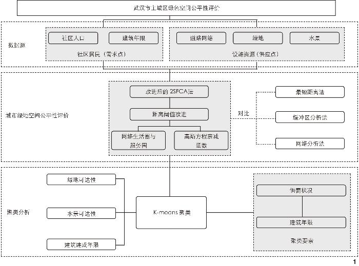
This research enhances the traditional two-step floating catchment area (2SFCA) method by integrating community attributes, blue-green space, and data on urban road network. Two key improvements are introduced: Incorporation of a distance decay threshold based on Gaussian equation and establishment of a 30-minute road network catchment area boundary. Three accessibility analysis methods — nearest distance method, buffer zone method, and network analysis method — are compared with the improved 2SFCA method. Additionally, based on the data on the age of community buildings, the distribution of urban green space resources is classified into four categories — “insufficient supply − aging buildings”, “insufficient supply − newer buildings”, “sufficient supply − aging buildings”, and “sufficient supply − newer buildings” — through the K-means clustering method. The classification results are visualized, and targeted recommendations are proposed for decision-makers. This research evaluates and visualizes the allocation of blue-green space resources and the clustering results for 1,025 communities within the central urban area of Wuhan. Based on these findings, tailored suggestions are provided for reference by decision-makers to guide future improvements.
1) The accessibility results obtained by the nearest distance method, the buffer zone method, and the network analysis method overestimate the distribution of urban green space resources in Wuhan. In contrast, the 2SFCA method more accurately reflects the imbalance in green space distribution. 2) The inequality in the allocation of urban green spaces displays significant spatial effects, with accessibility to greenery and water bodies increasing from the city center to the periphery, showing patterns of spatial clustering. More than half of the communities have lower-than-average accessibility to urban green spaces, and substantial differences in the supply-demand ratios of blue-green space exist across different regions. The integrated design and development of waterfront spaces can help mitigate the inequality in urban green space allocation to some extent, although excessively large water bodies can negatively impact the accessibility of green space. 3) The spatial distribution of communities across different categories is correlated with the urban development patterns. For aging communities with insufficient supply, a “squeeze-in” strategy to expand urban green space is recommended. For newer communities with insufficient supply, constructing pocket parks and removing barriers to park access are proposed. For aging communities with sufficient supply, landscape design that incorporates regional characteristics is suggested. For newer communities with sufficient supply, the planning of large parks and the strategic development of transportation routes are advised. Government-led initiatives to improve the quality of urban green space, along with policies aimed at enhancing residents’ mobility, can help alleviate green space inequality.
This research confirms the effectiveness of the improved 2SFCA method, which incorporates the daily travel behaviors of community residents, contributing to a more accurate representation of urban green space accessibility. The clustering results reveal a correlation between imbalances in urban green space distribution and urban development patterns, highlighting the importance of improving quality, providing policy guidance, and integrating regional culture to promote equity in green space allocation. In the context of urban renewal and transformation of aging communities, these findings may offer valuable insights for urban planners and researchers in the development of sustainable urban ecosystems.
REN yapeng , LIU Qiming , LIU Xin , LI Xin . Equity Evaluation of Green Space in the Central Urban Area of Wuhan from the Perspective of 30-Minute Community Life Circle[J]. Landscape Architecture, 2024 , 31(11) : 94 -102 . DOI: 10.3724/j.fjyl.202401150032
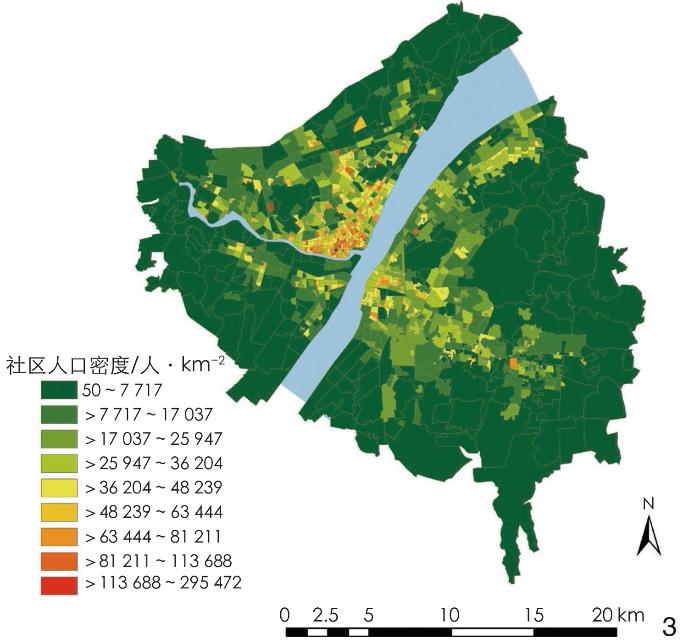
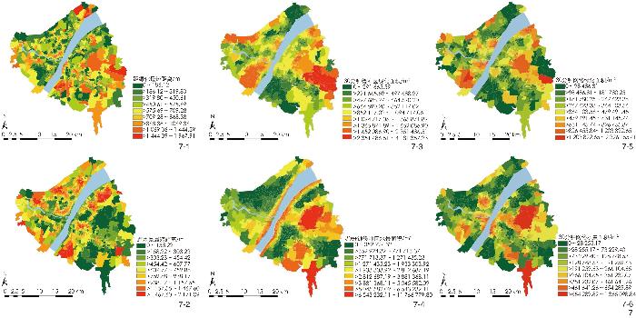
图3 社区人口密度空间分布Fig. 3 Distribution of community population density in the research area |
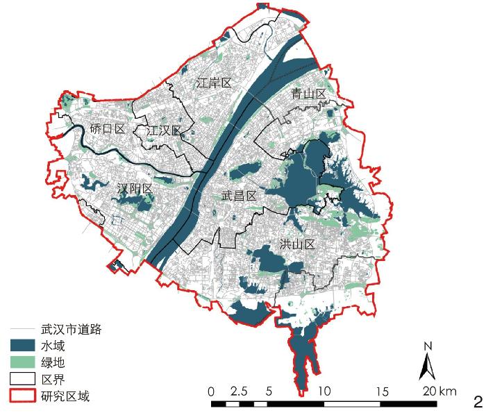
表1 各行政区指标统计Tab. 1 Statistics on indicators for administrative districts |
| 行政区 | 社区样本数 | 道路密度 均值/m·m−2 | 建筑建成年限 均值/年 | 绿地面积 均值/m2 | 水景面积 均值/m2 | 人口密度 均值/人·km−2 |
| 江岸区 | 187 | 0.019 | 19.610 | 26 770.510 | 440 040.400 | 29 230.784 |
| 硚口区 | 148 | 0.020 | 19.270 | 29 271.830 | 102 327.410 | 40 757.210 |
| 江汉区 | 116 | 0.022 | 20.020 | 21 928.700 | 5 510.550 | 40 114.280 |
| 汉阳区 | 132 | 0.014 | 16.690 | 100 229.970 | 113 242.140 | 14 922.150 |
| 武昌区 | 195 | 0.019 | 19.390 | 45 732.940 | 124 175.600 | 25 121.090 |
| 洪山区 | 167 | 0.016 | 15.410 | 172 291.060 | 697 149.550 | 14 504.080 |
| 青山区 | 80 | 0.017 | 17.640 | 35 230.360 | 9 059.800 | 24 464.970 |
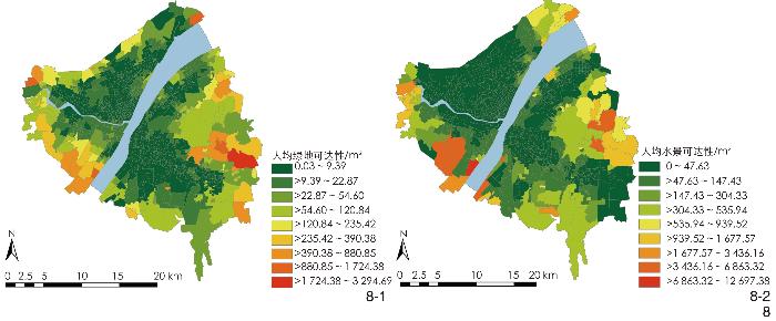
图8 使用改进后2SFCA法的可达性分析结果Fig. 8 Accessibility analysis by using the improved 2SFCA method |
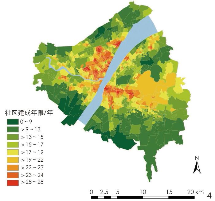
表2 各指标以及城市绿色空间可达性描述性统计Tab. 2 Descriptive statistics of indicators and accessibility of urban green space |
| 指标 | 总人口数 | 人口密度/ 人·km−2 | 建筑建成 年限/年 | 人均绿地可达性/m2 | 人均水景可达性/m2 |
| 最小值 | 8 | 50 | 0 | 0 | 0 |
| 最大值 | 53 850 | 295 472 | 28 | 3 295 | 12 697 |
| 均值 | 6 180 | 28 241 | 18 | 36 | 161 |
表3 聚类结果指标统计Tab. 3 Statistical indicators for clustering results |
| 聚类类型 | 社区样本数 | 建筑建成年 限均值/年 | 人均绿地可达性均值/m2 | 人均水景可达性均值/m2 |
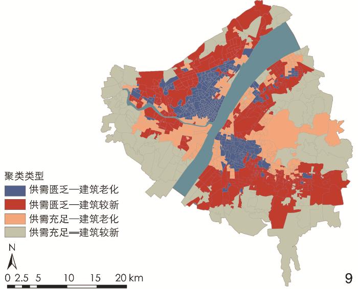
| 供需匮乏—建筑老化 | 350 | 21.140 | 4.420 | 8.660 |
| 供需匮乏—建筑较新 | 265 | 14.730 | 13.530 | 74.260 |
| 供需充足—建筑老化 | 311 | 20.000 | 15.580 | 105.820 |
| 供需充足—建筑较新 | 99 | 12.940 | 311.570 | 6 226.230 |
表4 K-means聚类轮廓系数检验结果Tab. 4 Results of silhouette coefficient analysis for K-means clustering |
| 聚类类型 | 社区样本数 | 平均值 | 最小值 | 最大值 |
| 供需匮乏—建筑老化 | 350 | 0.262 | −0.094 | 0.499 |
| 供需匮乏—建筑较新 | 265 | 0.181 | −0.142 | 0.419 |
| 供需充足—建筑老化 | 311 | 0.328 | 0.045 | 0.561 |
| 供需充足—建筑较新 | 99 | 0.247 | −0.154 | 0.498 |
| 总计 | 1 025 | 0.26 | −0.154 | 0.561 |
图9 景观可达性与建筑建成年限聚类结果Fig. 9 Clustering results of landscape accessibility and building age |
表5 不同类别社区景观优化策略Tab. 5 Optimization strategies for landscape in different categories of communities |
| 聚类类型 | 优化策略 |
| 供需匮乏—建筑老化 | 闲置空间再利用:规划滨江公园;配置屋顶花园 |
| 供需匮乏—建筑较新 | 建设微型口袋公园;打开周边公园边界 |
| 供需充足—建筑老化 | 加强绿地间连通性;保护现有绿地资源 |
| 供需充足—建筑较新 | 规划大型公园;增设交通路线,提高居民可达性 |
所有图表均由作者绘制。其中,
| [1] |
田明.城镇化率提升至“接近70%”, 意味着什么?[N/OL]. 新京报, 2024-08-02(A02)[2024-09-12]. http://epaper.bjnews.com.cn/html/2024-08/02/content_846851.htm.
TIAN M. What Does It Mean to Increase the Urbanization Rate to “Close to 70%”?[N/OL]. The Beijing News, 2024-08-02(A02)[2024-09-12]. http://epaper.bjnews.com.cn/html/2024-08/02/content_846851.htm.
|
| [2] |
Probabilistic Population Projections Based on the World Population Prospects 2024. Department of Economic and Social Affairs Population Division[EB/OL]. (2022-07-16)[2024-09-12]. https://population.un.org/wpp/.
|
| [3] |
马向明. 健康城市与城市规划[J]. 城市规划, 2014, 38 (3): 53-55
MA X M. Healthy City and Urban Planning[J]. City Planning Review, 2014, 38 (3): 53-55
|
| [4] |
武静, 蒋卓利, 吴晓露. 城市蓝绿空间的碳汇研究热点与趋势分析[J]. 风景园林, 2022, 29 (12): 43-49
WU J, JIANG Z L, WU X L. Analysis of Hotspots and Trends in the Research on Carbon Sink of Urban Blue-Green Space[J]. Landscape Architecture, 2022, 29 (12): 43-49.
|
| [5] |
阎姝伊, 李晓溪, 李婷, 等. 开放共享背景下城市公园绿地建设举措与路径探索[J]. 风景园林, 2024, 31 (2): 12-18
YAN S Y, LI X X, LI T, et al. Exploration of Construction Measures and Paths for Urban Parks and Green Spaces Under the Background of Opening and Sharing[J]. Landscape Architecture, 2024, 31 (2): 12-18
|
| [6] |
任亚鹏, 王江萍. 关于西南地区苗族传统聚落中自然要素的考察[J]. 风景园林, 2018, 25 (11): 117-122
REN Y P, WANG J P. An Investigation of Natural Elements in Traditional Settlements of Miao Ethnic Group in Southwest China[J]. Landscape Architecture, 2018, 25 (11): 117-122.
|
| [7] |
WANG K, SUN Z H, CAI M, et al. Impacts of Urban Blue-Green Space on Residents’ Health: A Bibliometric Review[J]. International Journal of Environmental Research and Public Health, 2022, 19 (23): 16192.
|
| [8] |
任亚鹏, 王江萍, 李欣. 海上丝路东海航线之濑户内海区域的景观振兴观察[J]. 风景园林, 2019, 26 (11): 38-44
REN Y P, WANG J P, LI X. Landscape Rehabilitation Observation of Seto Inland Sea Region on East Sea Route of Maritime Silk Road[J]. Landscape Architecture, 2019, 26 (11): 38-44.
|
| [9] |
朱力, 龙永红. 中国环境正义问题的凸显与调控[J]. 南京大学学报(哲学人文科学社会科学版), 2012, 49 (1): 48-54
ZHU L, LONG Y H. Environmental Justice in China: Problems and Solutions[J]. Journal of Nanjing University (Philosophy, Humanities and Social Sciences), 2012, 49 (1): 48-54.
|
| [10] |
王紫鹤, 王思元, 荣文卓. 景观公正的研究进展与多维评价方法探究[J]. 中国园林, 2023, 39 (9): 93-98
WANG Z H, WANG S Y, RONG W Z. Research Progress and Multidimensional Evaluation Methods of Landscape Justice[J]. Chinese Landscape Architecture, 2023, 39 (9): 93-98.
|
| [11] |
MITCHELL R, POPHAM F. Effect of Exposure to Natural Environment on Health Inequalities: An Observational Population Study[J]. The Lancet, 2008, 372 (9650): 1655-1660
|
| [12] |
MENG Y, XING H F, YUAN Y, et al. Sensing Urban Poverty: From the Perspective of Human Perception-Based Greenery and Open-Space Landscapes[J]. Computers, Environment and Urban Systems, 2020, 84: 14
|
| [13] |
白永平, 张文娴, 王治国. 基于POI数据的医药零售店分布特征及可达性: 以兰州市为例[J]. 陕西理工大学学报(自然科学版), 2020, 36 (1): 77-83
BAI Y P, ZHANG W X, WANG Z G. Distribution Characteristics and Accessibility of Pharmaceutical Retail Industry Based on POl Data: A Case Study of Lanzhou City[J]. Journal of Shaanxi University of Technology (Natural Science Edition), 2020, 36 (1): 77-83.
|
| [14] |
施拓, 李俊英, 李英, 等. 沈阳市城市公园绿地可达性分析[J]. 生态学杂志, 2016, 35 (5): 1345-1350
SHI T, LI J Y, LI Y, et al. Analysis of Urban Park Accessibility in Shenyang City[J]. Chinese Journal of Ecology, 2016, 35 (5): 1345-1350.
|
| [15] |
熊慧锦, 沈钦炜, 魏凌伟, 等. 基于网络分析的南昌市公园绿地可达性[J]. 中国城市林业, 2021, 19 (1): 89-94
XIONG H J, SHEN Q W, WEI L W, et al. Accessibility to Urban Park Green Space in Nanchang Based on Network Analysis[J]. Journal of Chinese Urban Forestry, 2021, 19 (1): 89-94.
|
| [16] |
OH K, JEONG S. Assessing the Spatial Distribution of Urban Parks Using GIS[J]. Landscape and Urban Planning, 2007, 82 (1-2): 25-32
|
| [17] |
LUO W, WANG F H. Measures of Spatial Accessibility to Health Care in a GIS Environment: Synthesis and a Case Study in the Chicago Region[J]. Environment and Planning B: Planning & Design, 2003, 30 (6): 865-884.
|
| [18] |
魏冶, 修春亮, 高瑞, 等. 基于高斯两步移动搜索法的沈阳市绿地可达性评价[J]. 地理科学进展, 2014, 33 (4): 479-487
WEI Z, XIU C L, GAO R, et al. Evaluation of Green Space Accessibility of Shenyang Using Gaussian Based 2-Step Floating Catchment Area Method[J]. Progress in Geography, 2014, 33 (4): 479-487
|
| [19] |
邱文, 贺利平, 钟乐, 等. 南昌市城市公园可达性综合评价[J]. 风景园林, 2023, 30 (4): 78-86
QIU W, HE L P, ZHONG L, et al. Comprehensive Evaluation of Accessibility of Urban Parks in Nanchang[J]. Landscape Architecture, 2023, 30 (4): 78-86
|
| [20] |
蔚芳, 王鑫. 基于2SFCA法的杭州体育活力空间可达性评价[J]. 城市规划, 2019, 43 (11): 112-119
WEI F, WANG X. Measuring Spatial Accessibility to Physical Activity Spaces In Hangzhou Using 2SFCA Method[J]. City Planning Review, 2019, 43 (11): 112-119.
|
| [21] |
黄骁然, 公丕欣, 张勃. 上海市养老助餐设施匹配以及空间分布研究[J]. 西部人居环境学刊, 2023, 38 (2): 30-37
HUANG X R, GONG P X, ZHANG B. Research on the Matching and Spatial Distribution of Meal-Aid Service for the Elderly in Shanghai[J]. Journal of Human Settlements in West China, 2023, 38 (2): 30-37.
|
| [22] |
胡昂, 刘洋洋, 戴维维, 等. 基于改进两步移动搜索法的城市公园绿地供需评价: 以成都市三环内为例[J]. 风景园林, 2022, 29 (9): 92-98
HU A, LIU Y Y, DAI W W, et al. Urban Park Green Space Supply and Demand Evaluation Based on Improved Two-Step Floating Catchment Area Method: A Case Study of the Area Within the Third Ring Road in Chengdu[J]. Landscape Architecture, 2022, 29 (9): 92-98.
|
| [23] |
陶卓霖, 程杨. 两步移动搜寻法及其扩展形式研究进展[J]. 地理科学进展, 2016, 35 (5): 589-599
TAO Z L, CHENG Y. Research Progress of the Two-Step Floating Catchment Area Method and Extensions[J]. Progress in Geography, 2016, 35 (5): 589-599
|
| [24] |
成玉宁, 王雪原. 城市蓝绿空间融合规划的生态逻辑[J]. 中国园林, 2023, 39 (10): 39-43
CHENG Y N, WANG X Y. Ecological Logic of Urban Blue-Green Space Integration Planning[J]. Chinese Landscape Architecture, 2023, 39 (10): 39-43.
|
| [25] |
葛梦婷, 陈乃光, 陈铭泽, 等. 环境正义对中国社区更新实践的影响[J]. 建筑与文化, 2023 (8): 122-125
GE M T, CHENG N G, CHENG M Z, et al. The Impact of Environmental Justice on the Practice of Community Renewal in China[J]. Architecture & Culture, 2023 (8): 122-125.
|
| [26] |
牛强, 胡金鹏, 梁晓倩, 等. 城内迁居导致的街区尺度人口动态变化测度及其空间分异特征: 基于手机信令数据的武汉市实证[J]. 地理科学进展, 2024, 43 (8): 1481-1495
NIU Q, HU J P, LIANG X Q, et al. Measurement of Neighborhood-Scale Population Dynamic Changes Due to Intracity Migration and Its Spatial Differentiation Characteristics: Empirical Evidence from Wuhan City Based on Mobile Phone Signaling Data[J]. Progress in Geography, 2024, 43 (8): 1481-1495
|
| [27] |
武汉市园林和林业局.2022年武汉市绿化状况公报[EB/OL].(2023-03-14) [2024-09-12]. https://ylj.wuhan.gov.cn/zwgk/zwxxgkzl_12298/tjxx/lhgb_12361/202303/t20230314_2169414.shtml.
Wuhan Municipal Landscape Gardens and Forestry Bureau. Bulletin if Wuhan Greening Situation in 2022[EB/OL]. (2023-03-14)[2024-09-12]. https://ylj.wuhan.gov.cn/zwgk/zwxxgkzl_12298/tjxx/lhgb_12361/202303/t20230314_2169414.shtml.
|
| [28] |
中华人民共和国住房和城乡建设部.城市绿地分类标准: CJJ/T 85—2017[S].北京: 中国建筑工业出版社, 2018.
Ministry of Housing and Urban-Rural Development of the People’s Republic of China. Standard for Classification of Urban Green Space: CJJ/T 85—2017[S]. Beijing: China Architecture & Building Press, 2018.
|
| [29] |
吴昊然, 高亮, 宋栋栋, 等. 全国六次人口普查区县级人口分布数据集[J]. 中国科学数据, 2022, 7(4): 306-312. https://www.scidb.cn/en/detail?dataSetId=849628989872930816.
WU H R, GAO L, SONG D D, et al. A Dataset of District/County-Level Population Distribution of China’s Six National Censuses[J]. China Scientific Data, 2022, 7(4): 306-312.
|
| [30] |
APPARICO P, ABDEIMAJID M, RIVA M, et al. Comparing Alternative Approaches to Measuring the Geographical Accessibility of Urban Health Services Distance Types and Aggregation Error Issues[J]. International Journal of Health Geographics, 2008, 7 (1): 7.
|
| [31] |
XING L J, LIU Y F, WANG B S, et al. An Environmental Justice Study on Spatial Access to Parks for Youth by Using an Improved 2SFCA Method in Wuhan, China[J]. Cities, 2020, 96: 102405.
|
/
| 〈 |
|
〉 |