
Research on the Spatial Heterogeneity of the Impact of Blue-Green Space Within Urban Block on Urban Thermal Environment
|
SHI Weihao is a Ph.D. candidate in the College of Architecture, Tianjin University. His research focuses on eco-city and climate resilience, and urban planning and design |
|
ZENG Suiping, Ph.D., is an associate professor in the College of Architecture, Tianjin Chengjian University. Her research focuses on urban physical environment optimization |
|
Aihemaiti NAMAITI (Uyghur) is a Ph.D. candidate in the College of Architecture, Tianjin University. His research focuses on urban climate and urban form optimization |
Received date: 2023-12-07
Revised date: 2024-08-12
Online published: 2025-12-16
Copyright
[Objective] Blue-green space is considered as an important ecological facility to optimize the thermal environment, whose positive effects on thermal environment optimization have gained widespread attention. Previous research has paid less attention to the construction of comprehensive indicators such as the scale, shape and layout of blue-green space, the spatial heterogeneity of the impact of blue-green space on the thermal environment, and the research unit of block, which makes it difficult to implement grounded optimization strategy for blue-green space as a response to thermal mitigation regulation. Thoroughly exploring the multi-dimensional impact of blue-green space on the thermal environment is beneficial for climate-adaptive urban development.
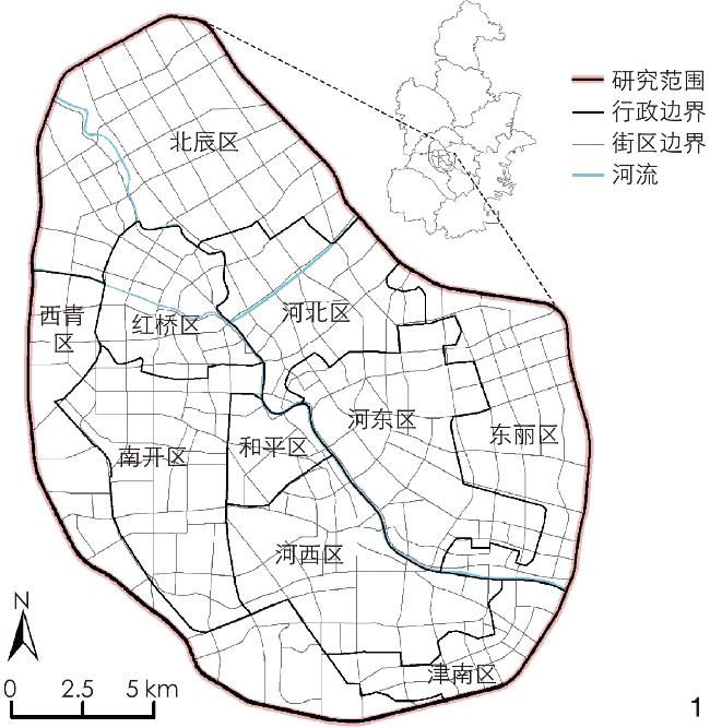
[Methods] This research takes the central urban area of Tianjin as the research area. The intense development and high-density construction in Tianjin have led to the fragmentation of blue-green space and the continuous deterioration of the thermal environment, making central Tianjin an area in urgent need of ecological transformation. Based on Landsat 8 remote sensing imagery and ENVI for land surface temperature (LST) inversion, the average of multiple datasets is utilized as the indicator to characterize the thermal environment. High-precision identification of blue-green space at a 2 m resolution is achieved through Google Earth images and eCognition 8.9 software. On this basis, combined with OpenStreetMap road data, over 300 blocks are delineated as the basic research units. Integrating landscape ecology and morphological analysis (morphological spatial pattern analysis, MSPA) based on ArcGIS Pro 3.0, Fragstats 4.2, and Guidos Toolbox 2.9 software, multi-dimensional evaluation indices of blue-green space at the block scale are calculated from the perspectives of “ scale − shape − layout” . Finally, a multiscale geographically weighted regression (MGWR) model is introduced to conduct the statistical analysis.
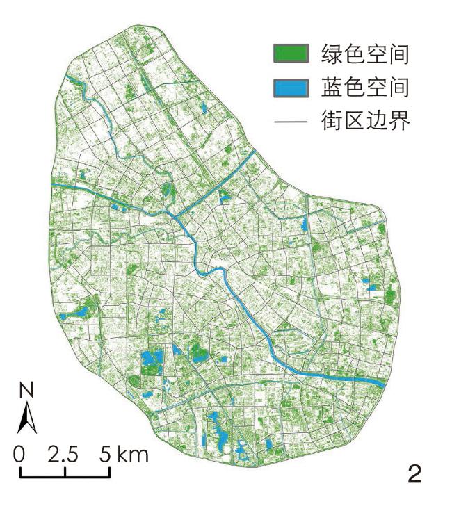
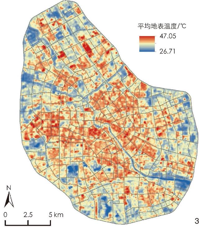
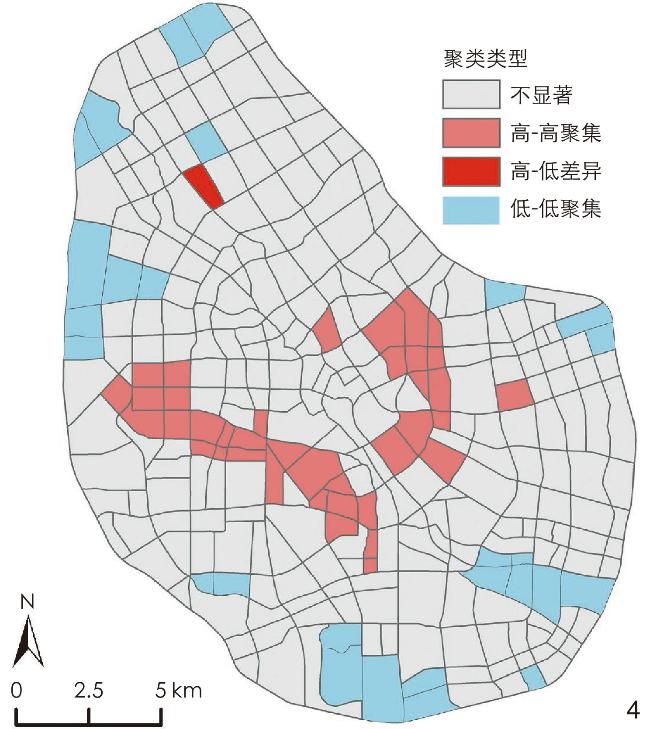
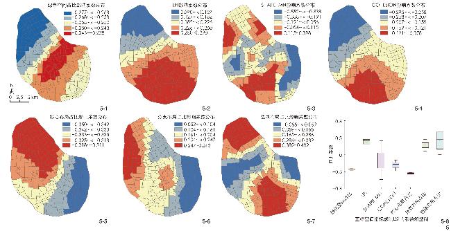
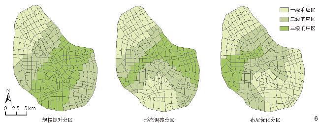
[Results] 1) The results show that the blue-green space in the central urban area of Tianjin exhibit a distribution characteristic of “four corridors and multiple points”, whereas the LST shows a distinct pattern of being “high in the center and low in the periphery”. The distribution of blue-green space in the central urban area of Tianjin is consistent with the low value of LST, and the scale, shape and layout of such blue-green space, as well as LST itself, all demonstrate spatial aggregation. 2) The core indicators of the impact of blue-green space on LST include the proportion of green space, LPI, COHESION, SHAPE_MN, the proportion of core layout, the proportion of branch layout, and the proportion of edge layout. Different indicators of blue-green space vary to a certain degree in terms of the scale of effects on the thermal environment. The SHAPE_MN index and the proportion of edge layout have smaller effect scales, exhibiting significant spatial heterogeneity. In contrast, the proportion of green space and that of core layout have larger effect scales, with a more gradual spatial heterogeneity in their impact. 3) Among the aforesaid indicators of blue-green space, the proportion of green space, the proportion of core layout, and COHESION index have a significant negative impact on the thermal environment. In contrast, the proportion of branch layout and that of edge layout have a significant positive effect. The intensity of impact varies among the indicators, with the average impact strength of the proportion of core layout being the highest, while that of SHAPE_MN being the lowest and unstable. Finally, based on empirical results, the research proposes an optimization scheme for blue-green space to improve the thermal environment. The scheme involves dividing the urban area into responsive zones based on the multi-scale spatial heterogeneity of the indicators of blue-green space, and optimizing the scale, shape and layout indicators of blue-green space at the block level according to their respective impact strength. The three-level optimal zoning of blue-green space is delimited, and precise optimization methods are proposed respectively for the scale, shape and layout of blue-green space. Specifically, in terms of the scale of blue-green space, it is supposed to take advantage of every opportunity to increase greenery and bluey; in terms of the shape of blue-green space, it is supposed to optimize the shape based on decentralized connection; and in terms of the layout of blue-green space, it is supposed to integrate fragmented blue-green spaces into an interconnected network of blue-green spaces. The research results may provide a theoretical reference for the planning of blue-green space at the block scale from the perspective of thermal environment optimization.
[Conclusion] The research offers a comprehensive insight into the multi-dimensional and spatially heterogeneous impacts of blue-green space on the thermal environment within urban blocks. It underscores the potential of blue-green space in contributing to climate-adaptive urban development and provides targeted recommendations for the planning and management thereof. These include optimizing the scale, form, and layout of blue-green space to enhance their thermal mitigation capabilities. The findings may serve as a theoretical foundation for climate adaptation strategies in high-density urban areas and the fine management of urban blocks, advocating for a systematic integration of blue-green space into urban planning framework. Future research may separately assess blue and green spaces from the dimensions of scale, shape and layout and quantify their interactions to further explore the effects of blue-green space on the thermal environment. Additionally, with the improvement in data availability, a further research with high spatiotemporal ductility may be conducted across multiple time series and climatic zones.
Weihao SHI , Suiping ZENG , NAMAITI Aihemaiti . Research on the Spatial Heterogeneity of the Impact of Blue-Green Space Within Urban Block on Urban Thermal Environment[J]. Landscape Architecture, 2024 , 31(10) : 98 -105 . DOI: 10.3724/j.fjyl.202312070549
表1 蓝绿空间指标及其描述Tab. 1 Indicators of blue-green space and their description |
| 指标维度 | 指标名称 | 指标描述 | 取值范围 |
| 注:布局指标中的“布局占比”指该类布局指标占街区蓝绿空间总量的百分比。 | |||
| 规模 | 蓝绿空间占比 | 蓝绿空间总面积占整个街区面积的百分比 | 0~100% |
| 蓝色空间占比 | 水体总面积占整个街区面积的百分比 | 0~100% | |
| 绿色空间占比 | 绿地总面积占整个街区面积的百分比 | 0~100% | |
| 形态 | LPI | 在特定景观类别中最大斑块所占的总景观面积比例,反映景观的优势程度 | 0~100% |
| PD | 单位面积内景观斑块的数量,反映景观的破碎程度 | ≥0 | |
| LSI | 单位景观斑块的总长度与总面积的比值,反映景观斑块形状的复杂程度 | ≥1 | |
| SHAPE_MN | 单位各景观斑块的形状指数的均值,反映景观斑块形状的平均复杂程度 | ≥1 | |
| AI | 单位面积内斑块之间接触的边界长度与可能的最大接触边界长度的比值,反映景观斑块聚集的程度 | 0~100 | |
| COHESION | 景观中所有斑块的周长与面积的比值经过标准化处理后的和值,反映斑块在景观中的连通程度 | 0~100 | |
| 布局 | 核心布局占比 | 核心指面状、大型的自然或半自然斑块,如综合公园、大型绿地、社区公园等 | 0~100% |
| 孤岛布局占比 | 孤岛指相对孤立、碎片化分布的点状绿地斑块,如街区小型附属绿地、树丛等 | 0~100% | |
| 孔隙布局占比 | 孔隙指受到自然或人类活动干扰而出现退化的自然或半自然点状斑块 | 0~100% | |
| 边缘布局占比 | 边缘指不同用地之间具有边缘效应的线性过渡地带,如大型绿地外围的林带 | 0~100% | |
| 环路布局占比 | 环路指有利于加强大型斑块内部能量流动、同一核心区内部的线性生态绿廊,如大型绿地内部道路绿化带 | 0~100% | |
| 桥接布局占比 | 桥接指连接相邻两个不同核心区、能促进核心区之间的能量流动的线性绿化带或生态廊道,如道路绿化带 | 0~100% | |
| 分支布局占比 | 分支指仅一端连接着边缘、孔隙、环线、桥接的绿化线性廊道,如连接公园与住宅区等城市建设用地的绿化带 | 0~100% | |
文中图表均由作者绘制,其中底图范围来自天津市规划和自然资源局网站,审图号:津S(2017)007。
| [1] |
JONATHON T, PAUL W, MIKE D, et al. Mapping the Effects of Urban Heat Island, Housing, and Age on Excess Heat-Related Mortality in London[J]. Urban Climate, 2015, 14: 517-528.
|
| [2] |
CHEN B, KONG F H, MEADOWS M E, et al. The Evolution of Social-Ecological System Interactions and Their Impact on the Urban Thermal Environment[J]. Urban Sustainability, 2024, 4(1): 3
|
| [3] |
LIU H M, HUANG B, GAO S H, et al. Impacts of the Evolving Urban Development on Intra-Urban Surface Thermal Environment: Evidence from 323 Chinese Cities[J]. Science of the Total Environment, 2021, 771: 144810
|
| [4] |
李洪忠, 陈劲松, 韩宇, 等. 微观尺度城市热环境影响因素分析研究: 以深圳市罗湖区为例[J]. 生态环境学报, 2019, 28(8): 1622-1631.
LI H Z, CHEN J S, HAN Y, et al. Micro-Scale Research of the Impact Factors on Urban Thermal Environment: A Case Study of Luohu District, Shenzhen[J]. Ecology and Environmental Sciences, 2019, 28(8): 1622-1631.
|
| [5] |
郭宇, 王宏伟, 张喆, 等. 南京市热环境与地表覆被的时空尺度效应及驱动机制研究[J]. 生态环境学报, 2020, 29(7): 1403-1411.
GUO Y, WANG H W, ZHANG Z, et al. Spatio-Temporal Scale Effect and Driving Mechanism of Thermal Environment and Land Surface Cover in Nanjing[J]. Ecology and Environmental Sciences, 2020, 29(7): 1403-1411.
|
| [6] |
艾合麦提·那麦提, 曾穗平, 倪丽丽, 等.天津市中心城区典型城市形态原型中建筑形态的热环境效应[J]. 地理科学, 2024, 44(7): 1228-1236.
NAMAITI A, ZENG S P, NI L L, et al. Thermal Environmental Effects of Building Morphology in Typical Urban form Prototypes in the Central Urban Area of Tianjin[J]. Scientia Geographica Sinica, 2024, 44(7): 1228-1236.
|
| [7] |
WANG Q, WANG X N, ZHOU Y, et al. The Dominant Factors and Influence of Urban Characteristics on Land Surface Temperature Using Random Forest Algorithm[J]. Sustainable Cities and Society, 2022, 79: 103722
|
| [8] |
DIN D M U, SHAH A I, BHAT S A, et al. Blue Green Infrastructure as a Tool for Sustainable Urban Development[J]. Journal of Cleaner Production, 2021, 318: 128474
|
| [9] |
苏王新, 常青. 城市热缓解的基于自然的解决方案与实施路径: 以北京市为例[J]. 风景园林, 2022, 29(6): 26-32.
SU W X, CHANG Q. Nature-Based Solutions for Urban Heat Mitigation and Implementation Path Thereof: A Case Study of Beijing[J]. Landscape Architecture, 2022, 29(6): 26-32.
|
| [10] |
王晓娟, 孔繁花, 尹海伟, 等. 高温天气植被蒸腾与遮荫降温效应的变化特征[J]. 生态学报, 2018, 38(12): 4234-4244.
WANG X J, KONG F H, YIN H W, et al. Characteristics of Vegetation Shading and Transpiration Cooling Effects During Hot Summer[J]. Acta Ecologica Sinica, 2018, 38(12): 4234-4244.
|
| [11] |
YA S W, QING M Z, WAN L O. How to Quantify the Relationship Between Spatial Distribution of Urban Waterbodies and Land Surface Temperature?[J]. Science of the Total Environment, 2019, 671: 1-9.
|
| [12] |
成雅田, 吴昌广. 基于局地气候优化的城市蓝绿空间规划途径研究进展[J]. 应用生态学报, 2020, 31(11): 3935-3945.
CHENG Y T, WU C G. Planning Approach of Urban Blue-Green Space Based on Local Climate Optimization: A Review[J]. Chinese Journal of Applied Ecology, 2020, 31(11): 3935-3945.
|
| [13] |
杜红玉.特大型城市“蓝绿空间”冷岛效应及其影响因素研究[D]. 上海: 华东师范大学, 2018.
DU H Y. The Cool Island Effect of Urban Blue-Green Spaces and Impact Factors in Mega City: A Case Study of Shanghai[D]. Shanghai: East China Normal University, 2018.
|
| [14] |
YAO L, LI T, XU M X, et al. How the Landscape Features of Urban Green Space Impact Seasonal Land Surface Temperatures at a City-Block-Scale: An Urban Heat Island Study in Beijing, China[J]. Urban Forestry & Urban Greening, 2020, 52: 126704
|
| [15] |
ZHAO W Y, XIE Y G, GERTRUD J, et al. How Can Urban Green Spaces Be Planned for Climate Adaptation in Subtropical Cities?[J]. Ecological Indicators, 2017, 82: 152-162.
|
| [16] |
CAI Y W, JUN X L, CHUN F W, et al. Understanding the Relationship Between Urban Blue Infrastructure and Land Surface Temperature[J]. Science of the Total Environment, 2019, 694: 133742
|
| [17] |
XIAO M L, WEI Q Z. Optimizing Urban Greenspace Spatial Pattern to Mitigate Urban Heat Island Effects: Extending Understanding from Local to the City Scale[J]. Urban Forestry & Urban Greening, 2019, 41: 255-263.
|
| [18] |
GUAN H G, ZHI F W, YING B C. Complex Mechanisms Linking Land Surface Temperature to Greenspace Spatial Patterns: Evidence from Four Southeastern Chinese Cities[J]. Science of the Total Environment, 2019, 674: 77-87.
|
| [19] |
SI Y Y, ZUO Q C, BAI L Y, et al. Exploring the Relationship Between 2D/3D Landscape Pattern and Land Surface Temperature Based on Explainable Extreme Gradient Boosting Tree: A Case Study of Shanghai, China[J]. Science of the Total Environment, 2020, 725: 138229
|
| [20] |
HAO H, RONALD C E. Detecting Cooling Effect of Landscape from Composition and Configuration: An Urban Heat Island Study on Hangzhou[J]. Urban Forestry & Urban Greening, 2020, 53: 126719
|
| [21] |
苏王新, 张刘宽, 常青. 基于MSPA的街区蓝绿基础设施格局及其热缓解特征[J]. 生态学杂志, 2022, 41(6): 1173-1181.
SU W X, ZHANG L K, CHANG Q. Characteristics of Blue-Green Infrastructure and Its Relationship with Thermal Environment in Blocks Based on MSPA[J]. Chinese Journal of Ecology, 2022, 41(6): 1173-1181.
|
| [22] |
沈中健, 曾坚, 任兰红. 2002—2017年厦门市景观格局与热环境的时空耦合关系[J]. 中国园林, 2021, 37(3): 100-105.
SHEN Z J, ZENG J, REN L H. The Spatiotemporal Coupling Relationship of Landscape Pattern and Thermal Environment in Xiamen, 2002﹣2017[J]. Chinese Landscape Architecture, 2021, 37(3): 100-105.
|
| [23] |
王佳, 钱雨果, 韩立建, 等. 基于GWR模型的土地覆盖与地表温度的关系: 以京津唐城市群为例[J]. 应用生态学报, 2016, 27(7): 2128-2136.
WANG J, QIAN Y G, HAN L J, et al. Relationship Between Land Surface Temperature and Land Cover Types Based on GWR Model: A Case of Beijing-Tianjin-Tangshan Urban Agglomeration, China[J]. Chinese Journal of Applied Ecology, 2016, 27(7): 2128-2136.
|
| [24] |
LI Y, REN C, HO J Y, et al. Landscape Metrics in Assessing How the Configuration of Urban Green Spaces Affects Their Cooling Effect: A Systematic Review of Empirical Studies[J]. Landscape and Urban Planning, 2023, 239: 104842
|
| [25] |
LI X, STRINGER L C, DALLIMER M. The Role of Blue Green Infrastructure in the Urban Thermal Environment Across Seasons and Local Climate Zones in East Africa[J]. Sustainable Cities and Society, 2022, 80: 103798
|
| [26] |
岳文泽, 刘学. 基于城市控制性详细规划的热岛效应评价[J]. 应用生态学报, 2016, 27(11): 3631-3640.
YUE W Z, LIU X. Assessment on Heat Island Effect Based on Urban Regulatory Planning[J]. Chinese Journal of Applied Ecology, 2016, 27(11): 3631-3640.
|
| [27] |
宋鑫博, 黄鹤, 郭军, 等. 城市形态对夏季热环境影响研究: 以天津中心城区为例[J]. 生态环境学报, 2021, 30(11): 2165-2174.
SONG X B, HUANG H, GUO J, et al. Research on the Impact of Urban Morphology on Thermal Environment in Summer: A Case of Tianjin Central City[J]. Ecology and Environmental Sciences, 2021, 30(11): 2165-2174.
|
| [28] |
ZHAO W Y, YA W Y, GAO Y Y, et al. Spatiotemporal Patterns and Characteristics of Remotely Sensed Region Heat Islands During the Rapid Urbanization (1995−2015) of Southern China[J]. Science of the Total Environment, 2019, 674: 242-254.
|
| [29] |
CAO W, ZHOU W, YU W D, et al. Combined Effects of Urban Forests on Land Surface Temperature and PM2.5 Pollution in the Winter and Summer[J]. Sustainable Cities and Society, 2024, 104: 105309
|
| [30] |
陈明, 戴菲. 基于形态学空间格局分析的城市绿地对热环境的影响研究[J]. 生态环境学报, 2021, 30(1): 125-134.
CHEN M, DAI F. The Influence of Urban Green Spaces on Thermal Environment Based on Morphological Spatial Pattern Analysis[J]. Ecology and Environmental Sciences, 2021, 30(1): 125-134.
|
| [31] |
吴岩, 贺旭生, 杨玲. 国土空间规划体系背景下市县级蓝绿空间系统专项规划的编制构想[J]. 风景园林, 2020, 27(1): 30-34.
WU Y, HE X S, YANG L. Compilation Conception of City and County Level Blue-Green Space System Specialized Planning Under National Territory Spatial Planning System[J]. Landscape Architecture, 2020, 27(1): 30-34.
|
| [32] |
YANG D C, GAO C, LI L Y, et al. Multi-scaled Identification of Landscape Character Types and Areas in Lushan National Park and Its Fringes, China[J]. Landscape and Urban Planning, 2020, 201: 103844
|
| [33] |
LICHTBLAU E, OSWALD C J. Classification of Impervious Land-Use Features Using Object-Based Image Analysis and Data Fusion[J]. Computers, Environment and Urban Systems, 2019, 75: 103-116.
|
| [34] |
TAN X Y, SUN X, HUANG C D, et al. Comparison of Cooling Effect Between Green Space and Water Body[J]. Sustainable Cities and Society, 2021, 67: 102711
|
| [35] |
向炀, 周志翔. 蓝绿空间景观格局对城市热岛的影响[J]. 中国园林, 2023, 39(1): 105-110.
XIANG Y, ZHOU Z X. Influence of Blue-Green Spatial Landscape Pattern on Urban Heat Island[J]. Chinese Landscape Architecture, 2023, 39(1): 105-110.
|
| [36] |
何侃, 林涛, 吴建芳, 等. 基于空间优先级的福州市中心城区绿色基础设施网络构建[J]. 应用生态学报, 2021, 32(4): 1424-1432.
HE K, LIN T, WU J F, et al. Construction of Green Infrastructure Network Based on Spatial Priority in Downtown of Fuzhou, China[J]. Chinese Journal of Applied Ecology, 2021, 32(4): 1424-1432.
|
| [37] |
洪婷婷, 黄晓辉, 邓西鹏, 等. 基于MSPA的城市绿色基础设施与热环境关系研究: 以福州市中心城区为例[J]. 中国园林, 2023, 39(10): 97-103.
HONG T T, HUANG X H, DENG X P, et al. Study on the Relationship Between Urban Green Infrastructure and Thermal Environment Based on Morphological Spatial Pattern Analysis: A Case Study of Central Urban Area of Fuzhou City[J]. Chinese Landscape Architecture, 2023, 39(10): 97-103.
|
| [38] |
陈泓宇, 李雄. 基于MSPA-InVEST模型的北京中心城区绿色空间生境网络优化[J]. 风景园林, 2021, 28(2): 16-21.
CHEN H Y, LI X. Optimization of Green Space Habitat Network of Central Beijing Based on MSPA-InVEST Model[J]. Landscape Architecture, 2021, 28(2): 16-21.
|
| [39] |
沈体雁, 于瀚辰, 周麟, 等. 北京市二手住宅价格影响机制: 基于多尺度地理加权回归模型(MGWR)的研究[J]. 经济地理, 2020, 40(3): 75-83.
SHEN T Y, YU H C, ZHOU L, et al. On Hedonic Price of Second-Hand Houses in Beijing Based on Multi-scale Geographically Reighted Regression: Scale Law of Spatial Heterogeneity[J]. Economic Geography, 2020, 40(3): 75-83.
|
| [40] |
OSHAN T M, SMITH J P, FOTHERINGHAM A S. Targeting the Spatial Context of Obesity Determinants Via Multiscale Geographically Weighted Regression[J]. International Journal of Health Geographics, 2020, 19(1): 11
|
| [41] |
FOTHERINGHAM A S, YANG W B, KANG W. Multiscale Geographically Weighted Regression (MGWR)[J]. Annals of the American Association of Geographers, 2017, 107(6): 1247-1265.
|
| [42] |
JIANG Y F, JIANG S D, SHI T M. Comparative Study on the Cooling Effects of Green Space Patterns in Waterfront Build-Up Blocks: An Experience from Shanghai[J]. International Journal of Environmental Research and Public Health, 2020, 17(22): 8684
|
| [43] |
XU Z Y, ZHAO S Q. Scale Dependence of Urban Green Space Cooling Efficiency: A Case Study in Beijing Metropolitan Area[J]. Science of the Total Environment, 2023, 898: 165563
|
| [44] |
赵海月, 胡淼, 朱建宁, 等. 高密度中心城区蓝绿空间冷岛效应及其影响因素: 以北京五环路以内地区为例[J]. 生态学报, 2023, 43(12): 4904-4919.
ZHAO H Y, HU M, ZHU J N, et al. Blue-Green Space Cooling Effect and Its Influencing Factors in Metropolitan Area: A Case Study on the Area Within the Fifth Ring Road in Beijing[J]. Acta Ecologica Sinica, 2023, 43(12): 4904-4919.
|
| [45] |
YANG F, YOUSEFPOUR R, ZHANG Y, et al. The Assessment of Cooling Capacity of Blue-Green Spaces in Rapidly Developing Cities: A Case Study of Tianjin’s Central Urban Area[J]. Sustainable Cities and Society, 2023, 99: 104918
|
/
| 〈 |
|
〉 |