
|
LIU Yizhuo is a master student in the College of Landscape Architecture, Northeast Forestry University. Her research focuses on ecological restoration, and urban ecosystem services |
|
DONG Sicun is a master student in the College of Landscape Architecture, Northeast Forestry University. Her research focuses on urban ecosystem services |
|
KONG Weiying is a master student in the College of Landscape Architecture, Northeast Forestry University. Her research focuses on cooling effects of urban blue-green spaces |
|
HU Yuandong (Tujia), Ph.D., is an associate professor in the College of Landscape Architecture, Northeast Forestry University. His research focuses on regional landscape planning and ecological restoration, and urban ecosystem services |
Received date: 2023-11-02
Revised date: 2024-08-11
Online published: 2025-12-16
Copyright
[Objective] Wilderness has important ecological functions and conservation values, and in the face of the current global climate change and the severe situation of rapid decline of biodiversity, the construction of wilderness protection system plays a key role in maintaining the integrity and authenticity of ecosystems, sustaining biodiversity, and enhancing human well-being. The quantitative and visual analysis of the spatial distribution characteristics of wilderness in Heilongjiang Province, an important ecological security barrier in the northern part of China, can not only comprehensively reflect the degree of human interference with nature, but also determine the reasonableness of the delineation of the scope of nature reserve, while contributing to the formulation of local wilderness protection strategy.
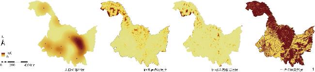
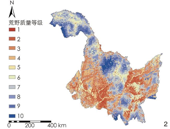
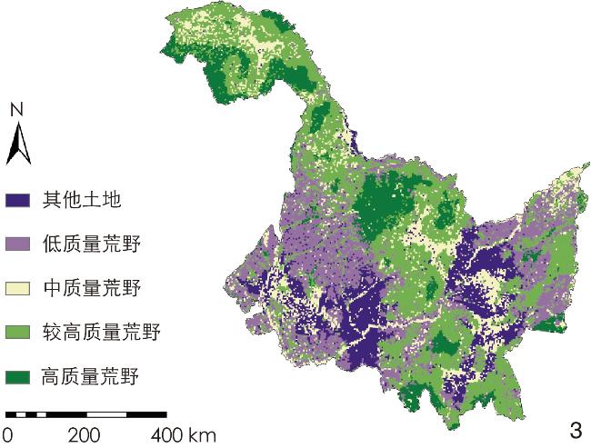
[Methods] Taking wilderness in Heilongjiang as the research object, this research selects the four indicators of remoteness from settlements, remoteness from accessible roads, population distribution density and biophysical naturalness to prepare the wilderness quality index map by the classical wilderness mapping method, Normalization is carried out using ArcGIS, and hierarchical analysis method (AHP) is applied to calculate the weights of the above four wilderness evaluation indicators with the four indicators being superimposed. Through the natural breakpoint method, the 10 grades of wilderness in Heilongjiang Province are classified into the following 5 categories: Other land (grade 1−2), low-quality wilderness (grade 3−4), medium-quality wilderness (grade 5−6), wilderness with relatively high quality (grade 7−8), and high-quality wilderness (grade 9−10). Additionally, The spatial distribution pattern of the wilderness land in Heilongjiang Province and the driving factors thereof are mapped and analyzed.
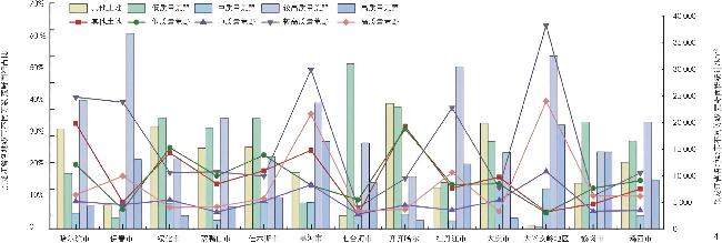
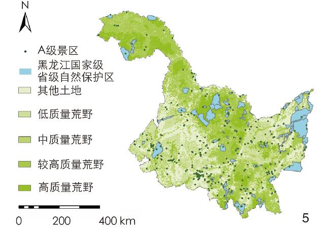
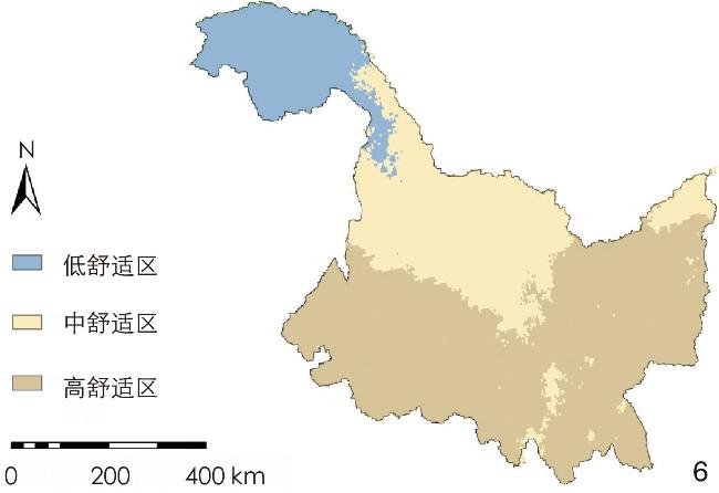
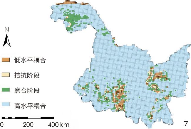
[Results] 1) The spatial pattern of wilderness in Heilongjiang Province shows an axial distribution, which is overall “low in the southwestern and southeastern areas, and high in the central axis belt area”. High-quality wilderness is mainly concentrated in Daxing’anling, Heihe, Mudanjiang and their surrounding areas, and within the long and narrow region, Daxing’anling borders Heihe, and Mudanjiang borders Yichun, forming a confrontation pattern of high-quality wilderness in the northwestern and southeastern parts of the province. In the southeastern and southwestern parts of Heilongjiang Province, the distribution area of low-grade wilderness centered on Harbin, Shuangyashan and other cities and counties is formed, showing a “cluster-type” distribution pattern. 2) In the research area, the area of wilderness above the low quality grade accounts for 79.79% of the total area of the research area, and that of wilderness above the relatively high quality grade accounts for 53.53% of the total area, indicating a large wilderness reserve in Heilongjiang Province. In the Daxing’anling region, the quality of wilderness is the highest, and the area of high-quality wilderness is the largest, amounting to 21,560 km2; the area of wilderness with relatively high quality is 35,900 km2, and the area of medium-quality wilderness is 8,300 km2, which is closely related to such factors as high density of forested land, high degree of naturalness, low degree of interference from human activities, and good quality of the ecological environment in the region. 3) The larger the average patch area in the horizontal spatial distribution pattern of wilderness, the lower the density of patch edge, the lower the degree of influence of the edge effect, and the higher the resistance to external interference. 4) In the research area, the area of high-quality wilderness and that of wildness with relatively high quality are respectively 30,728 km² and 371 km², and only 41.73% of the high-quality wilderness is in nature reserves, indicating that the existing nature reserves fail to fully cover the wilderness in the province. 5) By using Gross Demostic Product (GDP) to represent the economic development level of each prefecture-level city, the degree of coupling is calculated by coupling each city’s GDP ranking with its non-wilderness ranking, and by coupling the degree of climate comfort with the degree of wilderness. Economic development and climate comfort are found to be important drivers for the distribution of wilderness landscape pattern.
[Conclusion] The wilderness resources in Heilongjiang Province are rich and of high quality, while high-quality wilderness, although distributed in a concentrated manner, has not been completely and effectively protected at present. It is possible to consider establishing a clear hierarchical management mechanism for zoning protection; constructing a spatial protection axis of wilderness in Heilongjiang Province based on the spatial distribution characteristics of such wilderness for hierarchical protection; and strengthening public education on the wilderness environment to enhance the aesthetics of wilderness for citizens, so as to encourage them to appreciate the wilderness landscape and participate in the protection of wilderness lands on their own initiative. At the policy and legal levels, permanent and systematic protection of wilderness lands will be carried out, and a wilderness space protection system will be established in Heilongjiang Province. In the nature protection system, wilderness is recognized and spatially protected on the basis of the national park protection system and the delineation of ecological function zones and protection red lines. Economy and climate are important driving factors affecting the spatial distribution pattern of wilderness, and economic development inevitably requires urban development activities. In the future, Heilongjiang Province needs to balance the relationship between economic development and ecological protection, and realize the sustainable development of green economy.
Yizhuo LIU , Sichun DONG , Weiying KONG , Yuandong HU . Analysis of Wilderness Patterns in Heilongjiang Province[J]. Landscape Architecture, 2024 , 31(10) : 82 -89 . DOI: 10.3724/j.fjyl.202311020494
表1 数据来源Tab. 1 Data sources |
| 数据类型 | 数据描述 | 数据来源 |
| 土地利用数据 | 2020年全球土地利用数据,分辨率30 m | 中国科学院资源环境科学与数据中心(www.resdc.cn) |
| 道路数据 | 2020年全国基础地理数据库中公路、铁路要素层,比例1∶25万 | 全国地理信息资源目录服务系统 (www. webmap.cn) |
| 居民点数据 | 2020年全国基础地理数据库中居民地点 | 全国地理信息资源目录服务系统 (www. webmap.cn) |
| 数字高程数据 | ASTER GDEM数字高程数据,分辨率30 m | 中国科学院计算机网络信息中心地理空间数据云网站 (www.gscloud.cn) |
| 保护地边界矢量数据 | 黑龙江省省级以上自然保护区的边界范围 | 自然保护区标本资源共享平台 (www.papc.cn) |
表2 黑龙江省不同土地利用类型的生物物理自然度分级评价结果Tab. 2 Evaluation results of biophysical naturalness grading of different land use types in Heilongjiang Province |
| 编码 | 土地利用类型 | 自然度评分 | 编码 | 土地利用类型 | 自然度评分 |
| 11 | 水田 | 2 | 43 | 水库坑塘 | 3 |
| 12 | 旱地 | 2 | 44 | 滩涂 | 4 |
| 21 | 有林地 | 5 | 46 | 滩地 | 4 |
| 22 | 灌木林 | 4 | 51 | 城镇用地 | 1 |
| 23 | 疏林地 | 4 | 52 | 农村居民点 | 1 |
| 24 | 其他林地 | 3 | 53 | 其他建设用地 | 1 |
| 31 | 高覆盖草地 | 5 | 63 | 盐碱地 | 5 |
| 32 | 中覆盖草地 | 4 | 64 | 沼泽地 | 5 |
| 33 | 低覆盖草地 | 3 | 65 | 裸土地 | 4 |
| 41 | 河渠 | 4 | 66 | 裸岩石砾地 | 4 |
| 42 | 湖泊 | 5 |
表3 不同类型荒野的质量等级及其面积比重Tab. 3 Quality grades and area shares of different types of wilderness |
| 荒野质量水平 | 荒野等级 | 荒野面积/km2 | 面积占比/% |
| 其他土地 | 1 | 9 181 | 2.02 |
| 2 | 82 628 | 18.18 | |
| 低质量荒野 | 3 | 58 858 | 12.95 |
| 4 | 28 770 | 6.33 | |
| 中质量荒野 | 5 | 28 270 | 6.22 |
| 6 | 3 454 | 0.76 | |
| 较高质量荒野 | 7 | 137 032 | 30.15 |
| 8 | 32 588 | 7.17 | |
| 高质量荒野 | 9 | 61 130 | 13.45 |
| 10 | 12 544 | 2.76 |
表4 不同质量等级荒野的景观格局指数及保护区覆盖面积占比Tab. 4 Landscape pattern index and area share of protected areas in Heilongjiang Province |
| 荒野质量 水平 | 景观格局指数 | 保护区面 积/km2 | 保护区所 占比例/% | ||||||
| NP/ 个 | PD/ 个·km−2 | AREA_MN | ED/ hm2 | SHAPE_MN | CLUMPY/ % | COHESION/ % | |||
| 其他土地 | 512 | 0.16 | 70.12 | 19.60 | 1.26 | 0.88 | 99.36 | 10 680 | 11.63 |
| 低质量 荒野 | 715 | 0.17 | 11.01 | 23.30 | 1.29 | 0.85 | 99.48 | 9 816 | 11.20 |
| 中质量 荒野 | 488 | 0.11 | 69.54 | 20.67 | 1.24 | 0.88 | 99.27 | 6 795 | 21.39 |
| 较高质量 荒野 | 137 | 0.03 | 37.71 | 53.01 | 1.51 | 0.92 | 98.51 | 371 | 0.22 |
| 高质量 荒野 | 476 | 0.11 | 75.46 | 18.10 | 1.33 | 0.87 | 98.27 | 30 728 | 41.73 |
表5 2020年黑龙江省各地级市经济发展水平与其他土地类型占比的耦合度分析Tab. 5 Degree of coupling between economic development level and proportion of other land types of prefecture-level cities in Heilongjiang Province in 2020 |
| 地级市 | GDP 排名 | 其他土地面 积占比排名 | C (耦合度) | 耦合阶段 |
| 哈尔滨 | 1 | 5 | 0.75 | 磨合阶段 |
| 齐齐哈尔 | 3 | 3 | 1.00 | 高水平耦合 |
| 鸡西 | 8 | 8 | 1.00 | 高水平耦合 |
| 鹤岗 | 10 | 6 | 0.97 | 高水平耦合 |
| 双鸭山 | 9 | 7 | 0.99 | 高水平耦合 |
| 大庆 | 2 | 4 | 0.94 | 高水平耦合 |
| 伊春 | 11 | 11 | 1.00 | 高水平耦合 |
| 佳木斯 | 6 | 5 | 1.00 | 高水平耦合 |
| 七台河 | 12 | 2 | 0.70 | 高水平耦合 |
| 牡丹江 | 5 | 9 | 0.96 | 高水平耦合 |
| 黑河 | 7 | 10 | 0.98 | 高水平耦合 |
| 绥化 | 4 | 1 | 0.80 | 高水平耦合 |
| 大兴安岭 | 13 | 12 | 1.00 | 高水平耦合 |
文中图表均由作者绘制,其中
| [1] |
叶平. 生态哲学视野下的荒野[J]. 哲学研究, 2004(10): 64-69.
YE P. Wilderness from the Perspective of Ecological Philosophy[J]. Philosophical Studies, 2004(10): 64-69.
|
| [2] |
CEAUSU S, GOMES I, PEREIRA H M. Conservation Planning for Biodiversity and Wilderness: A Real-World Example[J]. Environmental Management, 2015, 55(5): 1168-1180.
|
| [3] |
LESSLIE R G, TAYLOR S G. The Wilderness Continuum Concept and Its Implications for Australian Wilderness Preservation Policy[J]. Biological Conservation, 1985, 32(4): 309-333.
|
| [4] |
MARTIN T G, WASTON J E M. Intact Ecosystems Provide Best Defense Against Climate Change[J]. Nature Climate Change, 2016, 6(2): 122-124.
|
| [5] |
曹越, 杨锐. 国际荒野地保护实践评析: 基于荒野制图、系统性与连通性的视角[J]. 中国园林, 2020, 36(6): 6-12.
CAO Y, YANG R. Research on the International Wilderness Conservation Practices: From the Perspectives of Wilderness Mapping, Systematic Conservation and Connectivity Conservation[J]. Chinese Landscape Architecture, 2020, 36(6): 6-12.
|
| [6] |
曹越, 杨锐. 中国荒野研究框架与关键课题[J]. 中国园林, 2017, 33(6): 10-15.
CAO Y, YANG R. The Research Framework and Key Issues of Chinese Wilderness Studies[J]. Chinese Landscape Architecture, 2017, 33(6): 10-15.
|
| [7] |
SANDERSON E W, JAITEH M, LEVY M A, et al. The Human Foot Print and the Last of the Wild[J]. Bio Science, 2002, 52(10): 891-904.
|
| [8] |
MCCLOSKEY J M, SPALDING H. A Reconnaissance Level Inventory of the Amount of Wilderness Remaining in the World[J]. AMBIO, 1989, 18: 221-227.
|
| [9] |
SEE L, FRITZ S, PERGER C, et al. Mapping Human Impact Using Crowd Sourcing[M]//CARVER S J, FRITZ S. Mapping Wilderness. Dordrecht: Springer, 2016: 89-101.
|
| [10] |
KUITERS A T, VAN EUPEN M, CARVER S, et al. Wilderness Register and Indicator for Europe[R/OL]. (2013-10)[2023-12-15]. https://wilderness-society.org/wp-content/uploads/2022/08/Wilderness_register_indicator.pdf.
|
| [11] |
APLET G, THOMSON J, WILBERT M. Indicators of Wildness: Using Attributes of the Land to Assess the Context of Wilderness[J]. Wilderness Science in a time of Change, 2000, 15(2): 89-100.
|
| [12] |
CARVER S, EVANS A, FRITZ S. Wilderness Attribute Mapping in the United Kingdom[J]. International Journal of Wilderness, 2002, 8(1): 24-29.
|
| [13] |
PLUTZAR C, ENZENHOFER K, HOSER F, et al. Is There Something Wild in Austria[M]//CARVER S J, FRITZ S. Mapping Wilderness. Dordrecht: Springer, 2016: 177-189.
|
| [14] |
RADFORD S L, SENN J, KIENAST F. Indicator-Based Assessment of Wilderness Quality in Mountain Landscapes[J]. Ecological Indicators, 2019, 97: 438-446.
|
| [15] |
CARVER S, TRICKER J, LANDRES P. Keeping It Wild: Mapping Wilderness Character in the United States[J]. Journal of Environmental Management, 2013, 131: 239-255.
|
| [16] |
曹越, 龙瀛, 杨锐. 中国大陆国土尺度荒野地识别与空间分布研究[J]. 中国园林, 2017, 33(6): 26-33.
CAO Y, LONG Y, YANG R. Research on the Identification and Spatial Distribution of Wilderness Areas at the National Scale in Mainland China[J]. Chinese Landscape Architecture, 2017, 33(6): 26-33.
|
| [17] |
ZODERER B M, CARVER S, TAPPEINER U, et al. Ordering “Wilderness”: Variations in Public Representations of Wilderness and Their Spatial Distributions[J]. Landscape and Urban Planning, 2020, 202: 103875
|
| [18] |
ŞTEFAN M D, COSTIN N M, COSMIN Ş E, et al. Wilderness Areas in Romania: A Case Study on the South Western Carpathians[M]//CARVER S J, FRITZ S. Mapping Wilderness. Dordrecht: Springer, 2016: 145-156.
|
| [19] |
李晓雪, 廖凌云, 兰思仁, 等. 福建省荒野地空间分布研究[J]. 陕西林业科技, 2021, 49(5): 20-27.
LI X X, LIAO L Y, LAN S R, et al. The Spatial Distribution of Wilderness Areas in Fujian Province[J]. Shaanxi Forestry Science and Technology, 2021, 49(5): 20-27.
|
| [20] |
张凯, 李巍, 漆建武. 荒野识别与荒野保护地研究: 以甘肃为例[J]. 中国园林, 2023, 39(12): 94-100.
ZHANG K, LI W, QI J W. Research on Wilderness Identification and Wilderness Preserves: Taking Gansu as an Example[J]. Chinese Landscape Architecture, 2023, 39(12): 94-100.
|
| [21] |
左翔, 彭树芳, 彭建松, 等. 曲靖市马龙区荒野格局分析[J]. 西南林业大学学报(自然科学), 2020, 40(1): 124-131.
ZUO X, PENG S F, PENG J S, et al. The Pattern Analysis of Wilderness in Malong District, Qujing City[J]. Journal of Southwest Forestry University (Natural Sciences), 2020, 40(1): 124-131.
|
| [22] |
左翔, 韩旭, 陈静, 等. 大理市荒野格局分析[J]. 中国园林, 2019, 35(11): 108-112.
ZUO X, HAN X, CHEN J, et al. The Pattern Analyze of Wilderness in Dali City[J]. Chinese Landscape Architecture, 2019, 35(11): 108-112.
|
| [23] |
高国荣. 近二十年来美国环境史研究的文化转向[J]. 历史研究, 2013(2): 116-132.
GAO G R. Cultural Shift in American Environmental History Research in the Last Two Decades[J]. Historical Research, 2013(2): 116-132.
|
| [24] |
舒峻峰.美国1964年荒野法研究[D].沈阳: 辽宁大学, 2013.
SHU J F. Research on American 1964 Wilderness Act[D]. Shenyang: Liaoning University, 2013.
|
| [25] |
吴保光.美国国家公园体系的起源及其形成[D].厦门: 厦门大学, 2009.
WU B G. The Research on the Origin and Formation of American National Park System[D]. Xiamen: Xiamen University, 2009.
|
| [26] |
高国荣. 美国著名环境史学家唐纳德·沃斯特教授访谈录[J]. 世界历史, 2008(5): 125-135.
GAO G R. Interview with Professor Donald Worst, a Famous American Environmental Historian[J]. World History, 2008(5): 125-135.
|
| [27] |
陈林博.重解“荒野”: 威廉·克罗农的环境史学思想述评[D].长春: 东北师范大学, 2012.
CHEN L B. Rethinking “Wildness”: The Environment Thoughts of William Cronon[D]. Changchun: Northeast Normal University, 2012.
|
| [28] |
陈林博. 威廉·克罗农的环境史研究中的主要观念探析[J]. 辽宁大学学报(哲学社会科学版), 2014, 42(4): 22-29.
CHEN L B. On the Main Ideas in William Cronon’s Environmental History Studies[J]. Journal of Liaoning University (Philosophy and Social Sciences Edition), 2014, 42(4): 22-29.
|
| [29] |
沙琢. 荒野的保护和管理[J]. 世界林业研究, 1997, 10(6): 28-32.
SHA Z. Protect and Management of Wilderness[J]. World Forestry Research, 1997, 10(6): 28-32.
|
| [30] |
杜颖, 蔡君. 美国荒野地游客教育系统及对我国的借鉴意义[J]. 四川林勘设计, 2008(1): 39-43.
DU Y, CAI J. The Education System of Tourists in the American Wilderness and Its Reference Significance to China[J]. Sichuan Forest Survey Design, 2008(1): 39-43.
|
| [31] |
宫丽彦, 程磊磊, 卢琦, 等. 荒地的概念、分类及其生态功能解析[J]. 自然资源学报, 2015, 30(12): 1969-1981.
GONG L Y, CHENG L L, LU Q, et al. Analysis of the Definition, Classification and Ecological Function of Wasteland[J]. Journal of Natural Resources, 2015, 30(12): 1969-1981.
|
| [32] |
任月.黑龙江省山水林田湖草生命共同体生态效率测度评价及实现路径研究[D]. 哈尔滨: 东北林业大学, 2022.
REN Y. Research on the Evaluation of Eco-efficiency Measurement and Realization Path of Life Community of Mountains, Waters, Forests, Fields, Lakes and Grasses in Heilongjiang Province[D]. Harbin: Northeast Forestry University, 2022.
|
| [33] |
李艳芳, 丁忠良, 王东伟, 等. 黑龙江省各市(地)生态环境状况评价[J]. 环境科学与管理, 2008(5): 153-155.
LI Y F, DING Z L, WANG D W, et al. Evaluation of Ecological Environment Status of Cities (Places) in Heilongjiang Province[J]. Environmental Science and Management, 2008(5): 153-155.
|
| [34] |
CAO Y, CARVER S, YANG R. Mapping Wilderness in China: Comparing and Integrating Boolean and WLC approaches[J]. Landscape and Urban Planning, 2019, 192: 103636
|
| [35] |
LIN S W, WU R D, HUA C L, et al. Identifying Local-Scale Wilderness for On-Ground Conservation Actions Within a Global Biodiversity Hotspot[J]. Scientific Reports, 2016, 6: 25898
|
| [36] |
CARVER S, COMBER A, MCMORRAN R, et al. A GIS Model for Mapping Spatial Pattern Sand Distribution of Wildland in Scotland[J]. Landscape and Urban Planning, 2012, 104: 395-409.
|
| [37] |
李恺. 层次分析法在生态环境综合评价中的应用[J]. 环境科学与技术, 2009, 32(2): 183-185.
LI K. Application of Analytical Hierarchy Process to Integrate Evaluation of Eco-environment[J]. Environmental Science and Technology, 2009, 32(2): 183-185.
|
| [38] |
LEU M, HANSER S E, KNICK S T. The Human Footprint in the West: A Large-Scale Analysis Is of Anthropogenic Impacts[J]. Ecological Applications: A Publication of the Ecological Society of America, 2008, 18: 1119-1139.
|
| [39] |
岑晓腾.土地利用景观格局与生态系统服务价值的关联分析及优化研究[D].杭州: 浙江大学, 2016.
CEN X T. Correlation Analysis and Optimization Between Land Use Landscape Patterns and Ecosystem Service Values: A Case Study of South Coast of Hangzhou Bay[D]. Hangzhou: Zhejiang University, 2016.
|
| [40] |
唐焰, 封志明, 杨艳昭. 基于栅格尺度的中国人居环境气候适宜性评价[J]. 资源科学, 2008(5): 648-653.
TANG Y, FENG Z M, YANG Y Z. Climate Suitability Evaluation of China’s Habitat Based on Raster Scale[J]. Resource Science, 2008(5): 648-653.
|
| [41] |
徐辉, 王亿文, 张宗艳, 等. 黄河流域水-能源-粮食耦合机理及协调发展时空演变[J]. 资源科学, 2021, 43(12): 2526-2537.
XU H, WANG Y W, ZHANG Z Y, et al. Mechanism of Water-Energy-Food Coupling and Spatial and Temporal Evolution of Coordinated Development in the Yellow River Basin[J]. Resource Science, 2021, 43(12): 2526-2537.
|
| [42] |
李剑源. 我国自然保护区发展中的问题与对策[J]. 江苏林业科技, 2006(4): 50-53.
LI J Y. Problems and Countermeasures in the Development of Nature Reserves in China[J]. Jiangsu Forestry Science and Technology, 2006(4): 50-53.
|
| [43] |
胡毛, 吕徐, 刘兆丰, 等. 国家公园自然教育途径的实践研究及启示: 以美国、德国、日本为例[J]. 现代园艺, 2021, 44(5): 185-189.
HU M, LYU X, LIU Z F, et al. Practical Research and Revelation of Nature Education Pathway in National Parks: The Example of the United States, Germany and Japan[J]. Modern Horticulture, 2021, 44(5): 185-189.
|
| [44] |
王伟, 李俊生. 中国生物多样性就地保护成效与展望[J]. 生物多样性, 2021, 29(2): 133-149.
WANG W, LI J S. In-Situ Conservation of Biodiversity in China: Advances and Prospects[J]. Biodiversity, 2021, 29(2): 133-149.
|
| [45] |
黑龙江省统计局, 国家统计局黑龙江调查总队.2023年黑龙江省国民经济和社会发展统计公报[EB/OL].(2024-06-11)[2024-08-20]. https://www.hlj.gov.cn/hlj/c108419/202406/c00_31742258.shtml.
Heilongjiang Provincial Bureau of Statistics, National Bureau of Statistics Heilongjiang Survey Team. Heilongjiang Province National Economic and Social Development Statistical Bulletin for 2023[EB/OL]. (2024-06-11)[2024-08-20]. https://www.hlj.gov.cn/hlj/c108419/202406/c00_31742258.shtml.
|
| [46] |
王汶, 鲁旭. 基于GIS的人居环境气候舒适度评价: 以河南省为例[J]. 遥感信息, 2009(2): 104-109.
WANG W, LU X. Evaluation of Climate Comfort of Human Settlements Based on GIS: Take Henan Province as an Example[J]. Remote Sensing Information, 2009(2): 104-109.
|
| [47] |
吴承照, 刘广宁. 管理目标与国家自然保护地分类系统[J]. 风景园林, 2017, 24(7): 16-22.
WU C Z, LIU G N. Management Objective and the National Conservation Natural Areas Classification System[J]. Landscape Architecture, 2017, 24(7): 16-22.
|
| [48] |
赵智聪, 彭琳, 杨锐, 等. 国家公园体制建设背景下中国自然保护地体系的重构[J]. 中国园林, 2016, 32(7): 11-18.
ZHAO Z C, PENG L, YANG R, et al. Reconstruction of China’s Nature Reserve System in the Context of National Park System Construction[J]. China Landscape Architecture, 2016, 32(7): 11-18.
|
| [49] |
李敬尧, 王建明. 城镇化进程中荒野保护的价值思考[J]. 湖州师范学院学报, 2016, 38(3): 24-29.
LI J Y, WANG J M. Thoughts on the Value of Wilderness Protection in the Process of Urbanization[J]. Journal of Huzhou Normal University, 2016, 38(3): 24-29.
|
/
| 〈 |
|
〉 |