Special: Vernacular Landscape and Heritage Cognition

Digital Technologies and Integrated Methods in Vernacular Landscape Research

  • Jingyu LI , 1, 2 ,
  • Xi WANG , 3, 4, * ,
  • Stoffelen (NL) Arie 2
Expand
  • 1 Department of Cultural Geography, University of Groningen
  • 2 Department of Earth and Environmental Sciences, KU Leven, Belgium
  • 3 Department of Urban Planning at Tongji University
  • 4 Postdoctoral Innovation Practice Base of Shanghai Pudong Urban Planning

LI Jingyu, Ph.D., is a postdoctoral researcher in the Department of Cultural Geography, University of Groningen, and an assistant research fellow in the Department of Earth and Environmental Sciences, KU Leven, Belgium. Her research focuses on landscape governance, community participation, and heritage conservation and tourism.

WANG Xi, Ph.D., is a postdoctoral researcher in the Department of Urban Planning at Tongji University, and a joint-supervision postdoctoral researcher in the Postdoctoral Innovation Practice Base of Shanghai Pudong Urban Planning & Design Institute. Her research focuses on living heritage community, world heritage cultural landscape, historic urban landscape

(NL) Arie Stoffelen, Ph.D., is an assistant professor in the Department of Earth and Environmental Sciences, KU Leuven, Belgium, and the associate editor of the international academic journal Annals of Tourism Research. His research focuses on tourism geographies

Received date: 2024-05-30

  Revised date: 2024-09-02

  Online published: 2025-12-16

Copyright

Copyright © 2024 Landscape Architecture. All rights reserved.

Abstract

[Objective] In recent years, research on vernacular landscapes has shifted from a primary focus on physical entities and historical significance to a greater emphasis on the perception of landscape value by individuals and communities. This paradigm shift has been significantly supported by the advent of digital technologies, which offer a diverse tools and methodologies. This study aims to explore the comprehensive application of digital technologies in vernacular landscape research.

[Methods] The study reviews and synthesizes the key research dimensions and digital methodologies employed in vernacular landscape studies. It identifies the essential elements and underlying meanings of vernacular landscapes, and elucidates the intrinsic connections between vernacular landscapes and the theory of sense of place concerning value perception. Additionally, it examines the role of vernacular landscapes within the context of cultural landscape heritage, focusing on their significance in heritage conservation and tourism.

[Results/conclusion] Building on this foundation, the study explores how digital technologies can be leveraged to collect landscape information, identify landscape value, and enhance the presentation and conservation of landscape heritage. It proposes an integrated research methodology that combines qualitative and quantitative analyses using digital tools. This approach aims to provide a more comprehensive, in-depth, and inclusive understanding of the value of vernacular landscapes, from data collection and analysis to visualization, while also offering technical support and data-driven foundations for their adaptive conservation.

Cite this article

Jingyu LI , Xi WANG , Stoffelen (NL) Arie . Digital Technologies and Integrated Methods in Vernacular Landscape Research[J]. Landscape Architecture, 2024 , 31(10) : 28 -39 . DOI: 10.3724/j.fjyl.202405300303

景观遗产的保护不仅对自然环境和文化的保护具有深远影响,也能显著推动地方经济的发展[11]。越来越多的学者提倡从遗产的研究以及具体的保护与管理实践出发,采取一种整体的方法来处理遗产问题[2-13]。这种整体性方法标志着研究者对文化景观遗产理解方式的重要转变,即从以专家为导向、以科学为驱动、强调遗产内在价值的传统观念,逐渐转向认识景观遗产价值的社会建构过程。当代遗产认知日益重视个人与社区如何看待和珍视景观中所蕴含的历史、文化及社会关系。在此背景下,“风土景观”的概念在文化景观遗产保护中愈发受到关注。风土景观可被定义为在地方层面上,通过当地居民的传统使用与活动逐步演变形成的具有历史与文化意义的区域[146]
对景观遗产保护的反思引发了研究主题与方法的转变。要理解风土景观,必须认识到它们并非静态存在,而是在当地社区、游客与环境的互动中不断演变。传统研究方法通常依赖以问卷调查为基础的定量分析,或以个人观点为基础的人类学定性分析:前者侧重于专家主导、以物质实体为中心,后者侧重个体主观意识,以被采访对象为中心。这些方法虽具价值,但在应对风土景观的复杂性与动态性方面可能存在局限[17],特别是在识别社区和空间之间的相互作用,以及人们对空间的解读方面。数字化转型为整合定性与定量研究的两类数据提供了契机,使人们能够更深入地理解风土景观的内涵[8-19]
本研究旨在探讨如何利用数字技术和不同的研究方法加深研究者对风土景观研究的理解。首先,以叙事式文献综述方法,重点关注风土景观和遗产认知论述中的数字技术和混合研究方法,探知风土景观研究在概念和方法上的转变。 其次,从景观、人文地理、遗产和数字人文的跨学科视角探讨3个基本理论框架:风土景观的内涵、风土景观与地方感之间的关系、作为遗产的文化景观。最后,为了帮助研究人员在数字时代有效地探究复杂的风土景观,提出一种整合各种数字技术的综合研究方法,以支持研究者有效地结合田野调查、档案研究以及数字数据分析等定性与定量方法。

1 风土景观的理论基础

1.1 风土景观的概念

景观作为风景园林学、生态学和地理学等多个学科的研究对象,其定义和研究视角因学科而异。工程师和自然科学家通常将景观视为一个客观实体,重点研究可测量的要素,如地形、植被、水文特征和建筑环境的空间布局。然而,景观供给不同人群共同居住和游览,每个人都会对景观的物理环境和社会构建产生影响。因此,从这一角度看,所有景观都可以在一定程度上被视为由人类活动塑造而成的。比利时著名景观研究学者Antrop教授将景观定义为一个综合的概念,即“既包括源自自然过程与人类活动之间持续动态互动的物质—物理现实,也涵盖了非物质的存在价值和符号,景观则是这些价值和符号的体现”[10],这种定义突破了将景观仅视为客观或主观的二元对立局面。将景观视为一个整体概念,意味着所有元素都是相互关联的,物质与非物质要素存在本质上紧密相连。
同理,风土景观不仅包括地方性的风土建筑、农场、渔场、土地利用和基础设施等有形要素,还强调了当地利益相关者所重视并代代相传的语言、历史、故事讲述、无形文化场所、记忆和文化知识等非物质要素[11]。景观研究中的乡土概念突出了人类与其生活环境之间的深刻联系,反映了一个社区的历史、价值观和习俗。这些联系有助于景观的价值阐释和适应性管理[21]

1.2 地方感和景观价值认知

Jackson在其开创性著作《发现乡土景观》中强调了地方感这一概念在理解景观中的重要性[22]。所谓地方感,指的是人们与特定地方之间形成的情感纽带,涵盖了从地方中感受到的价值和意义,以及被人们珍视的地方所具有的独特品质[14]。风土景观体现着个人与周围环境之间的情感和功能关系,这些关系包括地方依恋、归属感、文化符号、生物文化多样性、地方性知识等多方面内容[23-25],反映了人们的地方感。
风土景观和地方感有着相互影响、相互塑造的特点。一方面,人们的地方感影响着他们对风土景观价值的认知和对遗产管理方式的偏好,从而使得风土景观随之演变[22]。社区居民在不断适应环境变化的过程中,逐步塑造这些景观,使其生动地体现代代相传的生活习俗。农田、村庄、风土建筑和文化遗址等风土景观元素随着时间的推移不断变化,以满足社区不断变化的需求和价值观[26]。例如,世界遗产地武陵源风景名胜区内的一处农田被居民改造成观光景点,以迎合游客的喜好,这反映旅游业对社区居民价值观产生了影响,导致他们对风土景观进行了改造[27]。另一方面,人们的地方感也受不断变化的自然景观特征的影响。Stoffelen等指出,规划中所设定的保护边界、强调的保护对象,以及旅游设施的空间分布,有助于将某些世界观和土地利用的优先顺序规范化,从而影响社区与景观的互动方式以及人们对景观的感知[28]
景观价值可以被视为一种解释和量化地方感的概念工具。Brown等在其提出的景观价值分类中概述了人们赋予景观的主要价值类型,包括美学/风景、经济、娱乐、维持生命、学习/科学、生物、精神、内在、历史、未来、生存、治疗、文化、荒野、社会以及特殊场所价值[29]。运用这一景观价值的分类体系,研究人员可以衡量人们对特定研究区域的地方感,从而了解其风土景观蕴含的内在价值。

1.3 作为遗产的文化景观

文化景观是文化遗产保护与管理中的核心概念之一[30],用于描述人类活动与环境之间的相互作用[13]。世界遗产委员会将文化景观定义为“自然与人类共同创作的文化财产”,并分为3类:人类有意设计和创造的景观;有机演化的景观,包括遗迹(或化石)景观和延续性景观;“与自然元素的宗教、艺术或文化关联”而受到重视的“关联性文化景观”[31]。被列入世界遗产名录的文化景观必须具备“突出普遍价值”。然而日常生活中的普通景观也十分重要,却常常在遗产政策中被忽视[32]。围绕“谁的遗产?”和“谁的价值?”的问题,国际文化财产保护与修复研究中心(ICCROM)等组织提出了以人为本的遗产保护方法,强调将遗产视为促进社区福祉的动态资产,而非孤立的实体[33]
在研究中纳入对风土景观的主观诠释,不仅丰富了人们对文化景观遗产意义的理解,也突显了文化景观遗产以人为本的价值[34]。本地生活方式与风俗习惯展示了居民和利益相关者多元的文化价值观,理应被认可并加以保护。对日常生活中的风土景观与文化习俗的研究,拓宽了遗产研究的视野,为诠释景观遗产的价值提供了重要的概念框架。在构建和表达遗产价值的过程中,人类学方法被广泛应用,以探索多种主观认知、部分共享的记忆识别过程,以及潜在的群体内部与群体之间的紧张关系[35]。例如,在乡村景观中,这种方法揭示了村民如何通过创造性活动整体塑造景观,在农业土地利用中合理开发自然资源,并反映乡村景观深厚的文化根基[36]。联合国教科文组织推荐的历史性城市景观(HUL)方法也同样关注风土景观,HUL结合了“自下而上”的社会价值观表达,能够更好地识别文化多样性、不同人群间的潜在紧张关系,以及在快速的全球化背景下城市遗产的动态变化[37-38]
对风土景观所包含的社区视角的认知,不仅补充了文化景观的科学和社会价值,还对文化遗产旅游有重要意义[39]。国际古迹遗址理事会(ICOMOS)倡导对乡土遗产进行适应性改造和再利用[40]。风土景观作为潜在的乡土遗产,如果管理得当,以风土景观为核心的文化遗产旅游可以促进这些宝贵资源的保护和可持续管理。首先,旅游业能够为当地社区提供经济机会,并有助于维护遗产的真实性和完整性,如某些遗产地规定:将游客活动产生的旅游收入再投资于保护工作,以支持保护地区真实性和完整性的举措;又如,生态旅游被建议作为保护红河哈尼梯田系统的一种方法,因为低效率的传统种植对社区的福祉构成了挑战。其次,旅游业有可能促进和激励社区积极参与遗产的保护与管理[41]。此外,游客的反馈也有助于参与式景观设计的形成,如秘鲁的印加圣谷世界文化遗产管理者通过将不断演变的农业景观商品化,用于旅游开发,不仅使这些风景和农业实践得到了认可和保护,还推动了它们的可持续利用[42]

2 数字时代的风土景观研究

2.1 景观信息收集

为了记录风土景观的物质空间特征以及空间背后的意义,研究者利用数字技术开发了一系列的数据收集方法。例如利用GIS信息系统绘制地图,能够利用属性表突出各种元素的文化和历史意义。GIS还允许通过叠加不同的数据层,如历史土地利用模式、当前土地覆被情况和社会价值指标,揭示人与环境之间随时间变化的互动[43]。相比传统的实地研究和平面绘图方法,数字技术提供了更快速、精准且自动化的三维数据收集手段。其中,摄影测量和激光扫描是创建物理空间三维点云的主要方法[44],两种技术的设备都可安装在车辆或船只等各种平台上,具有极高的灵活性和适应性。特别是近年来无人机的广泛应用,进一步降低了三维空间数据采集的成本和复杂性,使得在较大尺度和复杂环境下的空间信息采集变得更加高效[19]。激光扫描利用机器人全站仪快速而准确地获取目标数据,激光扫描仪的视场角与人眼类似,能够由计算机控制并与全球定位系统(GPS)集成,适合记录从小型物体到大型复杂建筑的各种情况,同时捕捉所记录物体的几何形状和表面纹理细节[44]
这些方法使得研究者对风土景观的空间记录更加全面、直观。如杨晨等结合数字图像分析、近距离摄影测量和激光扫描技术来收集空间信息,制作了鲍家屯村的数字地表模型,将村落的空间格局清晰地展现出来;还通过激光扫描,创建了毫米级精度的点云模型[45]。通过激光扫描创建的高精度模型可用于三维打印,为建筑物的复制和重建提供详尽准确的资料。这一技术已广泛应用于西班牙教堂拱顶厚度的建模以及莫斯科舒克霍夫双曲面塔的测绘工作,为遗产的保护和修复提供依据[46-47]
语言、文字、语音记录、记忆、口述历史、传统知识和方言等非物质层面的风土景观要素,可以通过录音、摄像和摄影等方式记录,以捕捉这些无形元素如何与物理、社会和文化景观交织,并影响居民的生活[17]。随着人工智能生成内容(AIGC)技术的进步,如ChatGPT这样的大型语言模型已经能够被训练成讲故事的工具,用于诠释风土景观的非物质价值[48]。此外,构建知识图谱是对“知识的结构化表示,包括基本事实、普遍原则以及其他相关结构化数据”的一种方法[49],以连接图或链接数据的形式存储所有实体,通过节点和边展示这些实体之间的关系,也为记录非物质文化遗产提供了有效手段。以节点代表各种遗产实体,如民俗、音乐、舞蹈,并包含位置、历史和当前保护状态等相关信息,而边则显示这些实体之间的联系。这样的知识图谱作为一个结构化和可视化的信息库,便于信息的存储和检索,能够有效地理解和分析记录的数据[50]。然而,目前的文化遗产知识图谱主要以文本为基础,为了更全面地记录和分析风土景观遗产,未来开展的保护工作需要构建融合图像、短视频和三维点云等多模态数据的知识图谱。

2.2 景观价值认知与保护的数字化参与平台

近年来,基于地图的社区参与软件和在线平台(如Maptionnaire[51]、网络地理信息系统[52]、Greenmapper[43]和可视化巴拉瑞特[53]等)成为衡量人与地方之间联系的新工具,这些工具允许参与者在地图上添加点、线、多边形及意见。在风土景观遗产研究中应用这些工具,研究人员可以不受地点限制地收集人们对某些景观的意见,并与线上的参与者互动。这种线下社区与线上社区的融合,使得“兴趣社区”和“空间社区”得以结合。通过模糊物理领域与数字领域之间的界限,研究人员能够获取更广泛的数据来源,包括社交媒体互动和传统的实地观察。在巴拉瑞特数字历史性城市景观遗产信息服务中,WebGIS被用作整合历史地理信息和用户发起的各种文化专题地图的基础技术平台。这个在线互动系统采用了OpenStreetMap和Mapbox提供的地图和图像数据[53],用户可以通过电脑、平板电脑或智能手机访问地图上的城市历史信息,上传个人照片和徒步路线,将线上与线下的历史性城市景观体验有机结合[52]。用户所上传的信息将会成为研究该地区风土景观价值研究的一个主要数据来源。
结合传统的现场调查方法,数字平台有助于构建一个“实体与数字”参与者网络[54],从而扩大问卷调查或访谈对象的范围,更加全面地收集数据。数字平台也为参与者提供了一个表达他们对特定景观看法的机会。在参与式平台出现前,这些信息未能获得决策者的充分重视。如Sijtsma等在荷兰、德国和丹麦之间的国际瓦登海地区进行了一项多尺度文化生态系统服务的参与式制图研究,该研究通过对7 650名受访者在Greenmapper标准化问卷调查(www.greenmapper.org)中的回答进行分析,收集了地方、区域、国家和全球层面有关瓦登海自然景观吸引力的数据[43]。数字在线参与平台能使公众提供精确的地理空间信息,包括与地方感相关的信息。这些信息使研究人员能够对特定地方进行更全面、更细致的探索,从而为保护和管理相关的风土景观遗产提供依据[29, 43, 55]
随着社区广泛参与风土景观保护的需求日益增长,除了专门开发的基于地图的数字化平台,社交媒体在促进公众参与方面变得至关重要[56]。社交媒体为不同的利益相关者提供了发表意见的空间,能够有效促进集体记忆的收集、整理和分享,帮助研究人员识别并接触不同的利益群体,包括当地社区、政策制定者、遗产专业人士和游客[57]。Bai等提出了一种方法框架——利用非结构化的社交媒体数据创建与遗产价值和属性相关的基于图谱的多模型数据集[58],他们从Flickr等图片共享平台收集用户生成内容[59],对社交媒体中的用户生成图像数据进行主题聚类分析来分析游客的审美趣味以及他们对景观的理解[60]
数字化参与平台的应用不仅推动了遗产的保护,也增强了社区在管理文化景观中的积极参与能力[61]。参与式平台在记录公众观点并将其纳入遗产管理和规划中起到了关键作用。许多经验研究表明,社区的见解和专业知识对于风土景观的可持续发展至关重要,包括资源的合理利用、文化习俗的传承以及基层美学的维持[62-66]。了解居民的信仰、价值观和习俗,不仅有助于获得当地的支持,还能增强社区的归属感和责任感[67]

2.3 数字化风土景观在文化遗产保护与旅游中的应用

风土景观可以被转化为多种数字化形式,包括文本、数据库、静态与动态图像、音频、图形、软件以及网页等,形式还在不断增加。风土景观的数字化不仅为全面记录和理解文化遗产提供了便利,也为文化遗产旅游提供了提升游客的体验的新方法[68]。传统的二维地图和地理信息系统数据库依赖用户的空间推理能力,非专业人士往往难以理解,进而限制了用户体验和公众参与程度。相比之下,三维模型能够记录和展示遗址的物理结构,使遗产专业人员和社区能够更准确、经济的获取相关信息[69-70],例如可通过三维点云技术将城市形态、植被以及地下结构进行详细的可视化展示。
在风土景观遗产中应用虚拟现实(VR)、增强现实(AR)和混合现实(MR)技术,能够以数字化方式丰富和提升游客的体验,深化他们对风土景观遗产的文化和历史意义的理解[71]。基于点云数据,研究人员还可以借助人工智能技术对文化遗产进行虚拟修复、重建和模拟[72]。尽管跨尺度的时空动态技术仍需进一步发展,但VR技术已能够让研究人员和公众与计算机生成的环境进行互动,并通过VR头显在虚拟空间中导航。AR技术将数字信息叠加在现实世界之中,能够让用户同时看到现实世界与虚拟元素,并与之进行实时互动,使用户获得身临其境的体验[73]。例如,以意大利卡帕诺历史工业遗址为基础开发的AR游戏,通过提供工业、艺术和历史知识,进一步增强了游客的体验[74]。这些技术不仅可以从游客的视角将物质遗产与非物质遗产联系起来,还能带来更丰富的游客体验。ArkaeVision项目(digitalcomoedia.tv/dev/arkaevision/)通过虚拟现实技术对历史遗迹进行身临其境的三维重建,并通过AR技术将数字信息叠加到现实世界的文物视图上,从而通过交互式和情感化的体验提高用户的参与度和文化遗产教育[75]。MR技术则是通过配备透明屏幕和多个传感器的智能眼镜等专用硬件,将逼真的3D数字内容与用户的物理环境无缝融合[76]。通过这些技术,游客可以更深入地了解一个地区丰富的文化遗产,加深对其历史和传统的理解。
文化和社会价值应成为文化景观遗产数字化的重要组成部分。这不仅为最大限度地减少旅游业对遗产的负面影响提供了途径,也能够更好地保护自然景观元素,防止地方文化因过度旅游而消失[77-78]。这些技术使遗产变得更加具有参与性和互动性,不仅能够增强公众对文化遗产的理解和欣赏,还能确保文化遗产对后代的可持续影响。

3 在风土景观研究中融入数字技术

尽管越来越多的研究利用数字技术形成了风土景观的精细化研究框架[11, 92],但在将数字技术与传统方法结合、全面呈现风土景观的物质与非物质价值方面仍有不足。为此,本研究基于上述内容,针对风土景观研究的不同面向,提出了一种综合研究框架(图1),将定性、定量的混合研究方法与数字技术相结合,确保在不同视角和经验的基础上对风土景观进行全面评估。该方法分为3个关键步骤,每个步骤都应用特定的数字技术,有助于研究者全面理解和保护风土景观(表1)。
图1 风土景观理论基础与混合研究方法的关联框架

Fig. 1 Research framework linking the conceptual foundations of vernacular landscapes to mixed-methods research opportunities
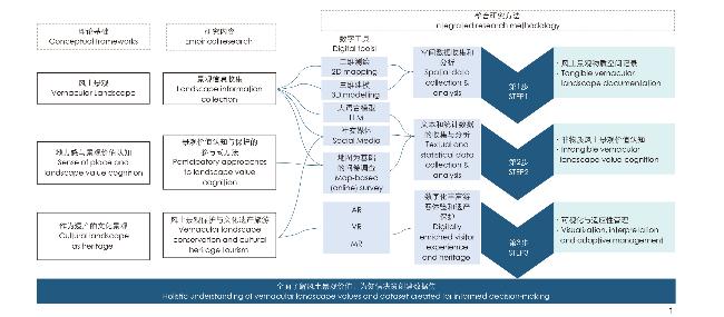
表1 风土景观研究步骤与数字技术的价值。

Tab. 1 Research steps for svernacular landscape highlighting the value of digital technologies

方法步骤
Methodological steps
数字工具
Digital tools
预期成果
Expected results
示例文献
Indicative references
1)风土景观空间记录
Tangible vernacular landscape documentation
利用公开、现场和旧地图相关数据进行二维制图;
利用数字图像分析、激光扫描(小尺度)和摄影测量(大尺度)进行三维建模
2D mapping using open, on-site, and old-map-related data; 3D modelling using digital image analysis, laser scanning (small scale), and photogrammetry (large scale)
有形景观价值的空间数据确定和评估保护要素
Spatial data of tangible landscape values identify and evaluate elements for conservation
[34~37]
2)非物质风土景观价值认知
Intangible value cognition
参与式地理信息系统;社交媒体和大语言模型
participatory GIS; social media and LLM
代表不同利益相关方的信息,以便做出知情决策
Information representing different stakeholders for informed decision making
[33] [38~49]
3)可视化和适应性管理
Visualization, interpretation and adaptive management
知识图谱、VR、AR、MR
Knowledge graph, VR, AR, MR
景观修复与展示、数字景观保护、提升游客体验、适应性管理
Landscape restoration and exhibition, digital landscape conservation, visitor experience, adaptive management
[59~67]

3.1 风土景观空间记录

第一步建议集中收集、制作和分析风土景观的空间信息,包括与地形、地理特征和行政边界相关的统计数据,以进行二维地图测绘和三维模型构建。在此过程中,GIS技术将发挥关键作用,研究人员能够直观地绘制和分析空间数据,从而全面了解风土景观的空间特征;此外,还能帮助构建风土景观特定特征的空间和时间演变数据库,用于评估建筑物分布、空间分析,以及研究土地使用的变化趋势。
为了获取详尽的三维数据,建议结合使用摄影测量和激光扫描技术,以提供高精度的图像和测距数据。然后,通过Geomagic Studio等软件进行数据处理,可以创建综合的点云和曲面模型。最终,通过将二维测绘与三维建模相结合,可以更准确地记录和展示风土景观中的复杂空间元素和特征,进而提供详细而全面的理解。

3.2 非物质风土景观价值认知

第二步建议全面分析利益相关者对风土景观的价值认知。这一过程应从访谈和问卷调查入手,深入了解各方对风土景观的看法;同时考虑从社交媒体平台获取数据,以补充和丰富定性数据来源。社交媒体提供了一个揭示利益相关者如何与风土景观互动以及他们如何重视这些景观的重要视角。然而,需要注意的是,社交媒体数据的使用可能会有一定的局限性,如社交媒体用户的观点可能无法代表所有利益相关者,某些平台在不同地区的普及程度也可能影响数据的全面性。因此,建议在分析社交媒体数据的同时,进一步对其他相关群体进行访谈和调查,确保数据的代表性和实用性,以获得更全面的风土景观价值认知。

3.3 风土景观的可视化与适应性管理

第三步建议将记录的有形和无形价值整合起来,创建全面的风土景观可视化和解释系统。研究者可利用点云数据将风土景观重建为计算机生成的虚拟物质空间环境,综合传统的问卷、访谈和人工智能技术收集非物质景观价值信息,可以进一步融合文本、图像、三维点云等多模态数据构建知识图谱。再结合VR、AR和MR技术增加风土景观呈现的生动性和互动性,使游客以沉浸式体验的方式与风土景观进行互动。
综合了有形和无形价值的数字化风土景观可以成为适应性保护管理的基础。将数字化的风土景观上传到一个线上公共平台,可以将静态数据库转化为互动平台。使用者可以在这个平台上分享与特定地点相关的记忆和故事。这种互动方式不仅有助于知识的生成,还能增强社区对遗产保护的参与感和能力。通过这样的平台,地方政府和城市规划者可以从信息数据中得出见解,更好地理解社区的需求和情感,从而制定出更加可持续和公平的发展方案。这种深入的互动和理解,有助于揭示风土景观的社会文化和自然意义,推动合作和积极的解决方案,为遗产保护和社区发展提供有力支持。

4 结论

本研究探讨了数字技术在风土景观研究中的重要作用,在传统方法论的基础上,提出了一种定量和定性结合的综合方法,可以结合专家分析与社区生活经验,确保研究结果更加全面,更能代表风土景观的真正本质,为数字时代的文化遗产保护和解释提供了更为有效的框架。因此,笔者倡导在风土景观研究中继续探索和应用数字工具,认识到它们改变和深化研究者对景观遗产保护参与方式的潜力。
未来的研究应进一步探索和完善这些方法,确保以严谨和尊重的态度研究和保护风土景观。数字技术的真正价值在于补充,而非取代传统方法和取样策略。通过采用最新技术,可以创建和存储更大规模的数据集,从而增进对风土景观的理解,促进中国及其他地区的可持续保护和发展。这将为研究者提供明确的机会,更好地保护和传承风土景观的独特价值。
There is scholarly consensus on the critical role of landscape heritage in ensuring sustainable futures. Landscape heritage protection and promotion can have a substantial impact on nature conservation, environmental justice, and local economic development[93]. Increasingly, researchers advocate for an integrated, holistic approach to heritage, in terms of conceptualizing and studying heritage but also in terms of concrete heritage conservation and management[94-95]. Such holistic approaches mark a transition in our understanding of cultural landscape heritage, from an expert-oriented, science-driven perspective that emphasized the intrinsic nature of heritage values to one that recognizes how landscape heritage values are socially constructed. Contemporary heritage understanding recognizes how individuals and communities perceive and value the history, culture, and social relations embedded within landscapes. In this context, the concept of a vernacular landscape has become increasingly important for cultural landscape heritage conservation. Vernacular landscapes can be defined as geographic areas that hold historical and cultural significance especially on the local level, and which have evolved through the traditional use and activities of the local inhabitants [96-98].
This conceptual shift in reflecting on landscape heritage has led to changes in research topics and methods. Understanding vernacular landscapes requires acknowledging that they are not static but constantly evolving through interactions between local communities, tourists, and the environment. Traditional research methodologies often emphasize survey-based quantitative methods with an expert-driven, object-focused approach to heritage, or rely on ethnographic qualitative data reflecting individual perspectives. While these methods are valuable, they can fall short in addressing the complex and dynamic nature of vernacular landscapes, including aspects like communities’ spatial literacy, subjectivity and cultural positioning, and the interpretation given to these places[99]. Additionally, digital transformations offer opportunities to integrate both types of data into immersive, co-constructed datasets, allowing for a more comprehensive understanding of the deep layers of vernacular landscapes[100-101].
The purpose of this paper is to explore how the utilization of digital technologies and different research methods enhance our understanding of vernacular landscape research. Firstly, the literature review employed a narrative approach focusing on digital technologies and mixed research methods in the discourse of vernacular landscape and heritage cognition. Secondly, drawing from interdisciplinary perspectives in landscape studies, human geography, heritage studies, and digital humanities, we explored three fundamental theoretical frameworks: the concept of landscape, the relationship between vernacular landscapes and sense of place, and cultural landscape as heritage. Finally,to help researchers effectively explore complex vernacular landscapes in the digital age, this paper proposes an integrated research approach that integrates various digital technologies support which effectively combine qualitative and quantitative methods such as fieldwork, archival research, and statistical data analysis.

1 Theoretical Foundations of Vernacular Landscape

1.1 The Concept of Vernacular Landscape

Landscape is a subject of study across various academic disciplines, such as landscape architecture, landscape ecology, and geography. Engineers and natural scientists often approach landscapes as objective entities, focusing on measurable elements such as topography, vegetation, hydrology, and the spatial characteristics of the built environment. However, landscapes are inhabited and visited by diverse groups of people, each contributing to their ongoing physical and social construction. In this sense, all landscapes can be seen as at least partially shaped by human activity. Antrop defined landscape as “a synthetic and integrating concept that refers both to a material-physical reality, originating from a continuous dynamic interaction between natural processes and human activity, and to the immaterial existential values and symbols of which the landscape is the signifier”[102]. This definition overcame the dualistic interpretation of landscape as either objective or subjective.
Viewing landscape as a holistic concept implies that nothing exists in isolation and that material landscape elements and immaterial existential are intrinsically interconnected. Similarly, vernacular landscapes not only include tangible elements such as vernacular architecture, farm, fisheries, agricultural fields and infrastructure, but also highlights the relevance of people’s perspectives such as language, history, storytelling, intangible cultural place, memories, and cultural knowledge that has been valued by local stakeholders and transmitted across generations[93]. The concept of vernacular in landscape research highlights a deep connection between people and the environment in which they live, reflecting a community’s history, values, and practices. These connections contribute to the value interpretation and adaptive management of landscapes[113].

1.2 Sense of Place and Landscape Value Cognition

In his seminal work, “ Discovering the Vernacular Landscape”, Jackson highlighted the importance of understanding the vernacular landscape in relation to sense of place[114]. The concept of sense of place refers to the emotional bonds, felt values, meanings, and valued qualities people have with specific places[96]. Vernacular landscapes reflect sense of place through their embodiment of the emotional and functional relationships between individuals and their surroundings, such as cultural identity, biocultural diversity, indigenous practices and resource use, local knowledge, community attachment, human-environment interactions[115-117].
People’s sense of place influences their preferences about how a landscape should be valued and how a heritage should be managed. On the one hand, vernacular landscape can change in response to the evolving senses of place[114]. While communities continually adapt to environmental changes, they shape these landscapes as living embodiments of practices that have evolved over generations. Vernacular landscapes features such as agricultural fields, rural villages, local building styles, and culturally significant sites, all of which adapt over time to meet the changing needs and values of the community[118]. For instance, agricultural fields in a rural village within the Wulingyuan Scenic and Historic Interest Area, a World Heritage site have been transformed into sightseeing attractions to cater to tourist preferences, illustrating the impact of touristification[119]. On the other hand, peoples’ senses of place are influenced by the changing physical characteristics landscape. Stoffelen et al, pointed out that boundaries set for protection, natural elements emphasized in plans, and the spatial distribution of tourism facilities institutionalize certain worldviews and land use priorities, shaping how communities interact with and perceive their landscapes[120].
Landscape values have been treated as emergent qualities of sense of place. In his landscape values typology, Brown, et al. outlined the key values people ascribe to landscapes: aesthetic/scenic, economic, recreation, life sustaining, learning/scientific, biological, spiritual, intrinsic, historic, future, subsistence, therapeutic, cultural, wilderness, social, and special places[121]. To understand the value of vernacular landscape, researcher could use this typology to measure people’s senses of place in a certain study area.

1.3 Cultural Landscape as Heritage

In cultural heritage conservation and management, cultural landscape serves as pivotal entities[122]. The concept of cultural landscape is utilized to describe the interaction between human activities and the environment[95]. The World Heritage Committee defines cultural landscape as “cultural properties that represent the combined works of nature and of man”. It is classified into three primary types: A landscape intentionally designed and created by humans; An “organically evolved landscape”, which can either be a “relict (or fossil) landscape” or a “continuing landscape”, and an “associative cultural landscape”; Valued for its “religious, artistic, or cultural associations with the natural element”[123]. World heritage cultural landscapes must have outstanding universal values. In heritage policies, there has been an oversight of ordinary landscape of everyday life despite their significance[124]. In the debate over “Whose heritage?” and “Whose values?”, a people-centered approach to heritage conservation, as advocated by organizations such as the International Centre for the Study of the Preservation and Restoration of Cultural Property (ICCROM), shifts the focus from viewing heritage as isolated entities to recognizing them as dynamic assets that contribute to community well-being[125].
The people’s subjective interpretation of vernacular landscape enriches the knowledge and people-centered significance of cultural landscape as heritage[126]. The vernacular heritage of ordinary people, which highlights the cultural diversity of heritage values as expressed by residents and stakeholders, deserves recognition, celebration, and protection. Research into vernacular landscapes and cultural practices in daily life has broadened the scope of heritage studies, offering a useful conceptual approach for interpreting landscape heritage values. Anthropological methods are employed to explore the multiple subjective perceptions, partly shared memory recognition processes, and potential intra-group and inter-group tensions in constructing and expressing heritage values[127]. For instance, in rural landscapes, this approach reveals the overall shaping process of creative activities carried out by villagers, utilizing natural resources in agricultural land use and reflecting their cultural roots[128]. Attention to vernacular landscapes can also be found in the Historic Urban Landscape (HUL) approach recommended by UNESCO, which integrates a “bottom-up” expression of social values and social choice. This approach can better recognize cultural diversity, potential tensions between different people, for example, resulting from heritage conservation and/or heritage-led tourism development, and the dynamic of urban heritage in the context of rapid globalization[129-130].
The recognition of the importance of subjective values of cultural landscape is not only for its scientific and social value but also for its significance in cultural heritage tourism[131]. International Council on Monuments and Sites (ICOMOS) advocates for the retrofitting and adaptive reuse of vernacular heritage[132]. If managed well, cultural heritage tourism centered around vernacular landscapes can contribute to the preservation and sustainable management of these valuable assets. Firstly, tourism can provide economic opportunities for local communities. Some heritage sites require tourism revenues generated from visitor activities to be reinvested into conservation efforts, supporting initiatives aimed at preserving the area’s authenticity and integrity. For example, encouraging ecotourism is proposed as one of the approaches to protect the Honghe Hani Rice Terraces System, because the low efficiency of traditional planting has create challenges for the community well-being patterns. Secondly, tourism has the potential to empower and incentivize communities to actively participate in heritage conservation and management[133]. Moreover, the feedback from the tourists can facilitate a participatory landscape design. The Inca Sacred Valley World Cultural Heritage in Peru, for example, commodified the historically evolved agricultural habitat for tourism purposes, which led to the recognition and conservation of the scenery and agricultural practices[134].

2 Vernacular Landscape Research in a Digital Age

2.1 Landscape Information Collection

To document the material spatial characteristics of vernacular landscapes and the meaning behind them, researchers have developed a range of data collection methods using digital technologies. GIS technology enabling researchers to create detailed maps that highlight the cultural and historical significance of various elements within the landscape in the attributes tables. By overlaying different data layers, such as historical land use patterns, current land cover, and social value indicators, GIS can also reveal the dynamic interactions between people and their environment over time[135]. Traditional field research and mapping methods are limited in terms of efficiency and accuracy in landscape information collection. Digital technologies can provide faster, more precise, and automated method for data collection. Among others, photogrammetry and laser scanning are two major ways of collecting information for creating 3D point clouds of a physical space[136]. Digital photogrammetry and laser scanning devices, which can be mounted on various platforms such as drones, vehicles, or vessels, offer exceptional flexibility and adaptability. The advent of airborne Light Detection and Ranging (LiDAR) technology has significantly enhanced the precision of data collection and spatial modeling in this field. In recent years, the widespread use of drones has further reduced the cost and complexity of spatial data acquisition. This versatility allows for the capture of spatial information across different scales and in complex environments[101]. Laser scanning uses a robotic total station to quickly and accurately acquire data from targets. With a field of view similar to human eyes, laser scanners can be computer-controlled and integrated with GPS, making them suitable for documenting anything from small objects to large complex building, capturing both the geometric and surface texture details of recorded objects[136].
These methods allow for a more comprehensive and intuitive spatial record of the vernacular landscape. Yang, et al. combined digital image analysis, close-range photogrammetry, and laser scanning technology to collect spatial information. They produced a a digital surface model (DSM) of Baojiatun village, clearly documenting the spatial pattern of the village. With laser scanning, They scanned the buildings to millimeter level accuracy, and created point cloud model[137]. Models created by laser scanning can be used for 3D printing, providing detailed and accurate information for replicating and reconstructing buildings. This technology has been applied to the modelling of thickness of vaults in the church in Spain, and the Shukhov hyperboloid tower in Moscow, informing heritage conservation and rehabilitation[138-139].
The intangible dimensions of vernacular landscape, such as language, text, voice recordings, memories, oral histories, traditional knowledge, and dialects, can be documented using voice recording, video, and photography to capture the intersecting physical, social, and cultural landscapes and their impact on residents[99]. With the advancements in Artificial intelligence generated content (AIGC), Large Language Models (LLM) like ChatGPT can be trained and guided to act as a story telling machine for the interpretation of intangible values of vernacular landscapes[140]. Furthermore, it is now possible to efficiently document intangible heritage using knowledge graphs. A knowledge graph is “a structured representation of knowledge, involves fundamental facts, universal principles, and other pertinent structured data”[141]. Knowledge graphs store all entities as connected graphs or linked data. This schema forms an expansive semantic web graph where nodes represent various heritage entities such as folklore, music, dance, and encompass related information like location, history, and current protection status, while edges establish connections between them. Such a graph serves as a structured and visually accessible repository, facilitating the storage and retrieval of information. This empowers to effectively comprehend and analyze recorded data[142]. However, current knowledge graphs for cultural heritage are predominantly text-based. Moving forward, the conservation of vernacular landscape heritage necessitates the construction of knowledge graphs that incorporate fused multimodal data, including images, short videos, and 3D point clouds.

2.2 Digital Participatory Platforms for Landscape Value Cognition and Conservation

In recent years, map-based community engagement software and online platforms, such as Maptionnaire[143], web GIS[144], Greenmapper[135], and visualizing Ballarat[145], emerged as new tools for measuring the connection between people and places. These tools enable participants to add points, lines, polygons and their opinions to the space in the map. Applying these tools to the research into vernacular landscape heritage, researchers could collect people’s opinions on certain landscapes without locational constrains and interact with participants of the online communities. The convergence of local and digital communities allows the fusion of a ‘community of interest’ with a ‘spatial community’. By blurring the lines between physical and digital realms, researchers can access a wider range of data sources, including social media interactions and traditional field observations. In the Ballarat Digital Heritage Information Services of HUL, web GIS is used as a basic technical platform to integrate historic geographic information and various cultural thematic maps initiated by users. This online interactive system uses advanced JavaScript from Leaflet’s open-source programming language library, along with mapping and image data from Open Street Map and Mapbox[145]. Users can access city history information on maps via computers, tablets, or smartphones, and upload personal photos and hiking routes to blend online and offline urban historical landscape experiences[144]. The information user upload will become a major data source for vernacular landscape research in a certain place.
Combined with traditional on-site survey methods, the digital platforms help create a so-called “phygital” network of people (i.e., both physical and digital)[146], and offers opportunities for them to express their value towards certain landscapes, which were probably not well recognized by decision-makers due to an absence of relevant information. Sijtsma, et al. on between the Netherlands, Germany and Denmark. The study used 7650 respondents’ answers to the standardized Greenmapper survey (www.greenmapper.org), collecting data about the attractiveness of nature of Wadden Sea at the local, regional, national and worldwide levels[135]. Digital platforms enable the public to provide accurate geospatial information, including information related to sense of place. This information enables researchers to explore specific places more comprehensively and in greater detail, thereby informing the conservation and management of the associated terroir and landscape heritage[121, 135, 147].
Given the growing need to involve a broader community in vernacular landscape conservation, social media has become vital for promoting public participation despite the map-based participatory digital platforms[148]. Social media platforms can facilitate the collection, curation, and sharing of collective memories, helping researchers identify and engage with a diverse range of stakeholders, including local communities, policymakers, heritage professionals, and tourists[149]. Platforms like WeChat, Flickr, X, Instagram, and specialized crowdsourcing websites can be used to gather community-generated content, providing up-to-date insights into how people perceive and interact with their landscapes. Bai, et al. propose the methodological framework of creating multi-model graph-based datasets about heritage values and attributes using unstructured social media data[150]. They employ this approach and use an image-sharing platform like Flickr to collect user generated content (UGC) and map public perceptions of urban heritage in Testaccio, Rome[151]. Through thematic clustering analysis of user generated image data in social media, researchers can analyse tourists’ aesthetic tastes and their understanding of the landscape[152].
The use of digital participatory platforms not only promotes heritage conservation, but also empowers communities to actively participate in the management of cultural landscapes[153]. Participatory platforms play a key role in documenting public views and incorporating them into heritage management and planning. Many empirical studies have shown that community insights and expertise are crucial for the sustainable development of terroir landscapes, including the rational use of resources, the transmission of cultural practices, and the maintenance of grassroots aesthetics[154-158]. Understanding the beliefs, values and practices of the residents not only helps to gain local support, but also enhances the sense of belonging and responsibility of the community[159].

2.3 Digital Vernacular Landscapes: Applications in Conservation and Tourism

Vernacular landscapes could be converted into digital materials include texts, databases, still and moving images, audio, graphics, software and webpages, among a wide and growing range of formats. Digitalization of vernacular landscape can not only comprehensively record, understand cultural heritage, but also present an innovative approach to enhance visitor experiences in cultural heritage tourism[160]. 2D maps and GIS databases are not always easy for laypersons to understand considering they depend on the spatial reasoning skills of the user, thereby limiting the user experience and potential of public participation. In contrast, 3D models can record and represent a site’s physical structure, making it accessible to heritage professionals and communities with accuracy and affordability[161-162]. For example, the use of 3D point clouds allows for the visualization of detailed urban forms, vegetation, and underground structures.
Applications of Virtual Reality (VR), Augmented Reality (AR) and Mixed Reality (MR) in vernacular sites can digitally enrich and improve visitor experiences, fostering a deeper understanding of the cultural and historical significance of vernacular landscape heritage[163]. Based on the point cloud data, researchers can use artificial intelligence to virtually restore, reconstruct and simulate cultural heritage[164]. Although cross-scale spatial and temporal dynamics requires further development of point cloud technologies, VR allows researchers and the public to interact with the computer-generated environments and navigate through space with virtual reality goggles. AR, which enables users to see and interact with both the real world and virtual elements simultaneously in real time, can create immersive experiences[165]. For example, an AR game developed for the historical industrial site of Carpano in Italy enhanced visitors’ experiences by providing industrial, artistic, and historical knowledge[166]. The technologies could be combined to create better visitor experiences, connecting tangible and intangible heritage in a tourist perspective. The ArkaeVision project uses VR to create immersive 3D reconstructions of historical sites and AR to overlay digital information onto real-world views of artifacts, enhancing user engagement and education in cultural heritage through interactive and emotionally engaging experiences[167]. While AR is the real world with digital information overlay, MR seamlessly merges realistic 3D digital content with the user’s physical environment using specialized hardware like smart glasses equipped with transparent screens and multiple sensors[168]. By engaging with these landscapes, tourists can gain insights into the rich cultural heritage of a region, fostering a deeper appreciation for its history and traditions.
The cultural and social values should be an essential part of the work of cultural landscape heritage digitization. It provides a suitable way to minimize negative tourism impacts on heritage. Without physically interfere with the heritage, the physical landscape elements can be better preserved, and local cultures are free from vanishing caused by overtourism[169-170]. By making heritage accessible, engaging, and interactive, these technologies can not only enhance public understanding and appreciation but also ensure the longevity and relevance of cultural heritage for future generations.

3 Integrating Digital Technologies in Vernacular Landscape Research

The descriptions of the three aspects of vernacular landscape research provide an overview of how various methods are used in different topics. Although there is an emerging body of literature use digital technologies to offer a nuanced framework for vernacular landscape research [93, 184], limited research has addressed how to combine digital technologies with the traditional methods to study and present the tangible and intangible value of vernacular landscape as a holistic entity. Thus, we propose an integrated research approach (Fig. 1) combining mixed methods with digital technologies to ensured that diverse perspectives and experiences are investigated, providing a comprehensive assessment of vernacular landscape. The approach is structured into three key steps. Each step has its special application of digital technologies and contributes to the comprehensive understanding and conservation of vernacular landscapes (Tab. 1).

3.1 Tangible Vernacular Landscape Documentation

The first step is to collect, produce, organize and analyze spatial information in the form of maps and 3D models, as well as statistical data in relation to topographic and geographic features and administrative boundaries. GIS technology enables the mapping and analysis of spatial data, allowing researchers to visualize and interpret the spatial dynamics of vernacular landscapes. Researchers can use GIS to construct spatial and temporal evolution databases of specific characteristics of vernacular landscapes, evaluate the distribution of buildings, conduct spatial analysis, and study the temporal evolution of landscapes, for example, regarding land use changes.
To acquire comprehensive data for 3D modeling, researcher can use a combination of photogrammetry and laser scanning to collect image and range data. These data could be processed with Geomagic Studio to create Photo-realistic models of integrated point clouds and surfaces. Thus, the combination of 2D and 3D mapping can document the complicated spatial elements and characteristics in a vernacular landscape.

3.2 Intangible Vernacular Landscape Value Cognition

The second step involves conducting a thorough analysis of stakeholders’ values towards the vernacular landscape. As an extension of interview and questionnaire survey, researchers could obtain data from social media platforms. With thoughtful implementation, social media platforms provide a rich source of qualitative data that can reveal insights into how stakeholders interact with and value these landscapes. Reliance on social media data may exclude perspectives from non-users or disregard that certain platforms can be less popular in certain regions, potentially skewing the representativeness and utility of the findings. Therefore, it is important to complement the online data with interview and survey of other relevant groups.

3.3 Visualization, Interpretation and Adaptive Management of Vernacular Landscape

The third step involves integrating the documented tangible and intangible values to create a comprehensive visualization and interpretation of the vernacular landscape. Using point cloud data, researchers can reconstruct the vernacular landscape into computer-generated environments, integrating traditional questionnaires, interviews, and artificial intelligence techniques to collect information on intangible landscape values. Using this information, researchers can further merge different data such as text, images, and 3D point clouds in constructing a knowledge graph. Combining VR, AR and MR technologies increases the vividness and interactivity of the environment so that visitors can interact with the terroir landscape in an immersive experience.
The digitalized tangible and intangible landscape can then be uploaded to an online public platform. This approach shifts from static databases to interactive platforms, where residents can contribute their memories and stories related to specific places. Presenting the holistic values of the vernacular landscape in an interactive manner not only facilitates knowledge generation but also empowers communities to safeguard their heritage. Moreover, it provides a data-driven foundation for informed decision-making. Such an interactive presentation helps to reveal the socio-cultural and physical significance of these places, enabling local governments and urban planners to better understand and empathize with communities. This deeper understanding fosters collaborative and positive solutions, ultimately supporting more sustainable and equitable development.

4 Conclusion

This paper demonstrated the role of digital technologies in vernacular landscape research, moving beyond traditional methodologies to embrace a more integrated approach. By combining quantitative and qualitative methods, the proposed integrated research approach bridging the gap between expert-driven analysis and the lived experiences of communities, ensuring that the research outcomes are more comprehensive and representative of the true essence of vernacular landscapes. As such, this paper advocates for a continued exploration and adoption of digital tools in vernacular landscape research, recognizing their potential to transform and deepen our engagement with landscape heritage.
Future research should continue to explore and refine these methodologies, ensuring that vernacular landscapes are studied and preserved with the rigor and respect they deserve. It is important to recognize that the true value of digital technologies lies primarily in their ability to complement, rather than replace, traditional methods and sampling strategies. Incorporating the latest technologies enable the creation and storage of lager datasets, offer clear opportunities to advance our understanding of vernacular landscapes and catalyze sustainable conservation and development efforts in China and beyond.

文中图表均由作者绘制。

[[1]
TRILLO C, ABURAMADAN R, MUBAIDEEN S, et al. Towards a Systematic Approach to Digital Technologies for Heritage Conservation. Insights from Jordan Preservation, Digital Technology & Culture 2020 49 4 121 138.

[2]
COCKS M, VETTER S, WIERSUM K F. From Universal to Local: Perspectives on Cultural Landscape Heritage in South Africa International Journal of Heritage Studies 2018 24 1 35 52.

DOI

[3]
LI J Y, STOFFELEN A, VANCLAY F. A Conceptual Framework and Research Method for Understanding Protected Area Governance: Varying Approaches and Epistemic Worldviews About Human-Nature Relations Journal of Environmental Planning and Management 2023 66 7 1393 1412.

DOI

[4]
WILLIAMS D R, STEWART S I. Sense of Place: An Elusive Concept that Is Finding a Home in Ecosystem Management Journal of Forestry 1998 96 5 18 23.

DOI

[5]
TAYLOR K, ALTENBURG K. Cultural Landscapes in Asia‐Pacific: Potential for Filling World Heritage Gaps International Journal of Heritage Studies 2006 12 3 267 282.

DOI

[6]
STOFFELEN A, KAMMINGA O, GROOTE P, et al. Making Use of Sense of Place in Amalgamated Municipalities Regional & Federal Studies 2024 34 4 521 543.

[7]
ZHAO X X, MARNANE K, GREENOP K. The Role of Digital Technologies in Recording Values of Human Settlements: Testing a Practical Historic Urban Landscape Approach in China and India Digital Creativity 2021 32 4 253 274.

DOI

[8]
RENES J. Layered Landscapes: A Problematic Theme in Historic Landscape Research[M]//HERMANS R, KOLEN J, RENES H. Landscape Biographies. Amsterdam: Amsterdam University Press, 2015: 402-422.

[9]
成实, 张潇涵, 成玉宁. 数字景观技术在中国风景园林领域的运用前瞻[J]. 风景园林, 2021, 28(1): 46-52.

CHENG S, ZHANG X H, CHENG Y N. Prospect of the Application of Digital Landscape Technology in the Field of Landscape Architecture in China[J]. Landscape Architecture, 2021, 28(1): 46-52.

[10]
ANTROP M. Sustainable Landscapes: Contradiction, Fiction or Utopia? Landscape and Urban Planning 2006 75 3-4 187 197.

DOI

[11]
ARMITAGE D, PLUMMER R, BERKES F, et al. Adaptive Co-management for Social-Ecological Complexity Frontiers in Ecology and the Environment 2009 7 2 95 102.

DOI

[12]
JACKSON J B. Discovering the Vernacular Landscape[M]. New Haven: Yale University Press, 1984.

[13]
ICOMOS. Charter On the Built Vernacular Heritage[EB/OL]. (1999)[2024-05-24]. https://www.icomos.org/images/DOCUMENTS/Charters/vernacular_e.pdf.

[14]
ALTABA P, GARCÍA-ESPARZA J A, VALENTÍN A. Assembling Cultural and Natural Values in Vernacular Landscapes: An Experimental Analysis Remote Sensing 2022 14 17 4155

DOI

[15]
KRASE J. Urban Vernacular Landscapes: Toward a Visual Pedagogy of the Ordinary International Review of Sociology 2023 33 2 181 213.

DOI

[16]
RAYMOND C M, MANZO L C, WILLIAMS D R, et al. Changing Senses of Place: Navigating Global Challenges[M]. 1st version. Cambridge: Cambridge University Press, 2021

[17]
LI J Y, STOFFELEN A, MEIJLES E, et al. Local People’S Sense of Place in Heavily Touristified Protected Areas: Contested Place Meanings Around the Wulingyuan World Heritage Site, China Landscape and Urban Planning 2023 237 104792

DOI

[18]
STOFFELEN A, GROOTE P, MEIJLES E, et al. Geoparks and Territorial Identity: A Study of the Spatial Affinity of Inhabitants with UNESCO Geopark De Hondsrug, The Netherlands Applied Geography 2019 106 1 10.

DOI

[19]
BROWN G, PAT R, RAYMOND C M. 2020. Mapping Place Values: 10 Lessons from Two Decades of Public Participation GIS Empirical Research Applied Geography 2020 116 102156

DOI

[20]
RAMSAY J. Editorial: Cultural Landscapes in the 21st Century: Issues and Opportunities Landscape Research 2015 40 6 649 654.

DOI

[21]
MITCHELL N J, RÖSSLER M, TRICAUD P M, et al. World Heritage Cultural Landscapes: A Handbook for Conservation and Management[M]. Paris: UNESCO World Heritage Centre, 2009.

[22]
JANSSEN J, KNIPPENBERG L. The Heritage of the Productive Landscape: Landscape Design for Rural Areas in the Netherlands, 1954−1985 Landscape Research 2008 33 1 1 28.

DOI

[23]
ICCROM. People-Centred Approaches to the Conservation of Cultural Heritage: Living Heritage[EB/OL]. (2015)[2024-05-24]. https://www.iccrom.org/sites/default/files/PCA_Annexe-2.pdf.

[24]
李光涵. 日常景观视角下的村落价值 中国文化遗产 2020 4 12 19.

DOI

LI G H. The Value of the Village from the Perspective of the Ordinary Landscape China Cultural Heritage 2020 4 12 19.

DOI

[25]
彭兆荣. 笔谈: 阐释与展示: 文化遗产多重价值的时代建构与表达 中国文化遗产 2023 3 4 9.

DOI

PENG Z R. Interpretation and Presentation:The Contemporary Construction and Expression of Multiple Values of Cultural Heritage China Cultural Heritage 2023 3 4 9.

DOI

[26]
杜晓帆, 全轶先. “活态”与“非物质”: 对文化遗产保护整体性的认知 中国非物质文化遗产 2024 1 102 105.

DU X F, QUAN Y X. “Living” and “Intangible”: Recognition of the Holistic Dimension of Cultural Heritage Conservation China Intangible Cultural Heritage 2024 1 102 105.

[27]
TAYLOR K. The Historic Urban Landscape Paradigm and Cities as Cultural Landscapes. Challenging Orthodoxy in Urban Conservation Landscape Research 2016 41 4 471 480.

DOI

[28]
周详, 刘子玥, 施佳颖. 数字足迹支持下的景观视觉感知评价: 以秦淮河历史性城市景观为例 风景园林 2022 29 9 18 25.

ZHOU X, LIU Z Y, SHI J Y. Evaluation on Visual Landscape Perception Under the Support of Digital Footprint: A Case Study of Historic Urban Landscape of the Qinhuai River Area Landscape Architecture 2022 29 9 18 25.

[29]
TIMOTHY D J. Heritage and Destination Conscience: Empowering Communities and Enhancing Tourism Experiences[M]//PECHLANER H, OLBRICH N, ISETTI G. Destination Conscience. Bingley: Emerald Publishing Limited, 2024: 51-63.

[30]
ICOMOS. International Charter for Cultural Heritage Tourism[EB/OL]. (2022)[2024-05-24]. http://www.icomoschina.org.cn/content/details94_11580.html

[31]
ZHANG Y X, MIN Q W, JIAO W J, et al. Values and Conservation of Honghe Hani Rice Terraces System as a GIAHS Site Journal of Resources and Ecology 2016 7 3 197 204.

DOI

[32]
ISHIZAWA M. Landscape change in the terraces of Ollantaytambo, Peru: An Emergent Mountain Landscape Between the Urban, Rural and Protected Area Landscape Research 2017 42 3 321 333, 67.

DOI

[33]
SIJTSMA F J, MEHNEN N, ANGELSTAM P, et al. Multi-scale Mapping of Cultural Ecosystem Services in a Socio-Ecological Landscape: A Case Study of the International Wadden Sea Region Landscape Ecology 2019 34 7 1751 1768.

DOI

[34]
LIANG H L, LI W Z, LAI S Q, et al. The Integration of Terrestrial Laser Scanning and Terrestrial and Unmanned Aerial Vehicle Digital Photogrammetry for the Documentation of Chinese Classical Gardens: A Case Study of Huanxiu Shanzhuang, Suzhou, China Journal of Cultural Heritage 2018 33 222 230.

DOI

[35]
YANG C, HAN F, SHUTTER L, et al. Capturing Spatial Patterns of Rural Landscapes with Point Cloud Geographical Research 2019 58 1 77 93.

[36]
HERRÁEZ J, NAVARRO P, DENIA J L, et al. Modeling the Thickness of Vaults in the Church of santa Maria de Magdalena (Valencia, Spain) with Laser Scanning Techniques Journal of Cultural Heritage 2014 15 6 679 686.

DOI

[37]
LEONOV A V, ANIKUSHKIN M N, IVANOV A V, et al. Baturin, Laser Scanning and 3D Modeling of the Shukhov Hyperboloid Tower in Moscow Journal of Cultural Heritage 2015 16 551 559.

DOI

[38]
TRICHOPOULOS G. Large Language Models for Cultural Heritage[C]//Association for Computing Machinery. Proceedings of the 2nd International Conference of the ACM Greek SIGCHI Chapter. New York: Association for Computing Machinery, 2023: 1-5.

[39]
FAN Z L, CHEN C C. CuPe-KG: Cultural Perspective-Based Knowledge Graph Construction of Tourism Resources Via Pretrained Language Models Information Processing & Management 2024 61 3 103646

[40]
陈昱成, 黎洋, 刘江峰, 等. AIGC视角下非物质文化遗产知识图谱的构建研究 科技情报研究 2024 6 2 115 12.

CHEN Y C, LI Y, LIU J F. Research on the Construction of Intangible Cultural Heritage Knowledge Graph from the Perspective of AIGC Scientific Information Research 2024 6 2 115 12.

[41]
KYTTÄ M, FAGERHOLM N, HAUSNER V H, et al. Maptionnaire[M]//BURNETT C M. Evaluating Participatory Mapping Software. Cham: Springer International Publishing, 2023: 71-91.

[42]
MARTÍNEZ-HERNÁNDEZ C, STOFFELEN A, PISKORSKI R. Obtaining Geographical Competences Through Online Cartography of Familiar and Unfamiliar Urban Heritage: Lessons from Student Workshops Journal of Geography in Higher Education 2024 48 1 74 93.

DOI

[43]
杨晨, 韩晓蓉. 巴拉瑞特2.0: 城市历史景观数字化遗产信息服务系统研究 中国园林 2020 36 10 29 34.

YANG C, HAN X R. Ballarat 2.0: Research on the Digital Heritage Information Services of Historic Urban Landscapes Chinese Landscape Architecture 2020 36 10 29 34.

[44]
AIMAR F. The Resilience of Cultural Landscapes: Perspectives from UNESCO World Heritage Sites[M]. Cham: Springer Nature Switzerland, 2024.

[45]
RZESZEWSKI M, SOWADA T, KOTUS J. Assessing the Usefulness of PPGIS for Qualitative Exploration of Human Relationships with Places: An Empirical Study[J]. Quality & Quantity, 2024.

[46]
LIANG X X, LU Y J, MARTIN J. A Review of the Role of Social Media for the Cultural Heritage Sustainability Sustainability 2021 13 3 1055

DOI

[47]
LIEW C L, GOULDING A, NICHOL M. From Shoeboxes to Shared Spaces: Participatory Cultural Heritage Via Digital Platforms Information, Communication & Society 2022 25 9 1293 1310.

[48]
BAI N, DUCCI M, MIRZIKASHVILI R, et al. Mapping Urban Heritage Images with Social Media Data and Artificial Intelligence, a Case Study in Testaccio, Rome[J]. The International Archives of the Photogrammetry, Remote Sensing and Spatial Information Sciences, 2023, XLVIII-M-2-2023: 139-146.

[49]
BAI N, NOURIAN P, LUO R, et al. Heri-Graphs: A Dataset Creation Framework for Multi-modal Machine Learning on Graphs of Heritage Values and Attributes with Social Media ISPRS International Journal of Geo-Information 2022 11 9 469

DOI

[50]
ZHOU X, LI J, LIU Y F. Landscape-based Heritage Research and Practice Landscape Architecture Frontiers 2023 11 3 11 37.

DOI

[51]
GARCÍA-RUIZ J M, LASANTA T, NADAL-ROMERO E, et al. Rewilding and Restoring Cultural Landscapes in Mediterranean Mountains: Opportunities and Challenges Land Use Policy 2020 99 104850

DOI

[52]
ROBERTS A R. “Until the Lord Come Get Me, It Burn Down, Or the Next Storm Blow It Away”: The Aesthetics of Freedom in African American Vernacular Homestead Preservation Buildings & Landscapes: Journal of the Vernacular Architecture Forum 2019 26 2 73 97.

[53]
LI J, KRISHNAMURTHY S, PEREIRA RODERS A, et al. Community Participation in Cultural Heritage Management: A Systematic Literature Review Comparing Chinese and International Practices Cities 2020 96 102476

DOI

[54]
VAN OERS R, BANDARIN F. Reconnecting the City: The Historic Urban Landscape Approach and the Future of Urban Heritage[M]. Hoboke: Wiley, 2014.

[55]
GREEN P E. Creole and Vernacular Architecture: Embryonic Syncretism in Caribbean Cultural Landscape The Journal of Architecture 2022 27 1 21 43.

DOI

[56]
ALLAN J R, POSSINGHAM H P, ATKINSON S C, et al. The Minimum Land Area Requiring Conservation Attention to Safeguard Biodiversity Science 2022 376 6597 1094 1101.

DOI

[57]
FREDHOLM S, ELIASSON I, KNEZ I. Conservation of Historical Landscapes: What Signifies “ Successful” Management? Landscape Research 2018 43 5 735 748.

DOI

[58]
RAPOPORT A. On Cultural Landscapes Traditional Dwellings and Settlements Review 1992 3 2 33 47.

[59]
ROSSATO L, MASSAI P, MAIETTI F, et al. Digital Tools for Documentation and Analysis of Vernacular Cultural Heritage in Indian City Centers International Journal of Architectural Heritage 2021 15 6 931 941.

DOI

[60]
JEFFREY S, JONES S, MAXWELL M, et al. 3D Visualisation, Communities and the Production of Significance International Journal of Heritage Studies 2020 26 9 885 900.

DOI

[61]
CALVI L, VERMEEREN A P O S. Digitally Enriched Museum Experiences: What Technology Can Do Museum Management and Curatorship 2023 39 3 335 356.

[62]
CAI Z R, FANG C Y, ZHANG Q, et al. Joint Development of Cultural Heritage Protection and Tourism: The Case of Mount Lushan Cultural Landscape Heritage Site[J], Heritage. Science. 2021, 9(1): 86.

[63]
MARTO A, GONÇALVES A, MELO M, et al. A Survey of Multisensory VR And AR Applications for Cultural Heritage Computers & Graphics 2022 102 426 440.

[64]
SPACCA S, DELLAPIANA E, SANNA A. Promoting Industrial Cultural Heritage by Augmented Reality: Application and Assessment The Open Cybernetics & Systemics Journal 2018 12 1 61 71.

[65]
BOZZELLI G, RAIA A, RICCIARDI S, et al. An integrated VR/AR Framework for User-Centric Interactive Experience of Cultural Heritage: The Arka Vision Project Digital Applications in Archaeology and Cultural Heritage 2019 15 00124

[66]
BUHALIS D, KARATAY N. Mixed Reality (MR) for Generation Z in Cultural Heritage Tourism Towards Metaverse[C]//STIENMETZ J L, FERRER-ROSELL B, MASSIMO D. Information and Communication Technologies in Tourism 2022. Springer Cham, 2022: 16-27.

[67]
RUHANEN L, WHITFORD M. Cultural heritage and Indigenous tourism Journal of Heritage Tourism 2019 14 3 179 191.

DOI

[68]
TIMOTHY D J. Views of the Vernacular: Tourism and Heritage of the Ordinary[M]. Contemporary Issues in Cultural Heritage Tourism. London: Routledge, 2013.

Outlines

/