
Research on Traditional Settlement System Dominated by Water Conservancy in the Shexibei Basin, Huizhou
|
WANG Kai gained his Master degree in Beijing Forestry University. He is a lead landscape planner in the Urban Planning & Design Institute of Shenzhen Co., Ltd. His research focuses on landscape planning and design, urban design, and digital space governance |
|
JI Wei is a master student in the School of Landscape Architecture, Beijing Forestry University. Her research focuses on traditional human settlements based on hydrology |
|
GUO Wei, Ph.D., is a professor and doctoral supervisor in the School of Landscape Architecture, Beijing Forestry University, and an editorial board member of this journal. His research focuses on traditional human settlements based on hydrology |
|
HOU Xiaolei, Ph.D., is a professor in and director of the Graduate Department of the School of Architecture, Central Academy of Fine Arts. Her research focuses on public space design and community construction, rural landscape design, and landscape planning and design |
Received date: 2023-12-22
Revised date: 2024-08-21
Online published: 2025-12-16
Copyright
[Objective] Huizhou has a long history of traditional water conservancy construction, which can be traced back to Baonanhui project built in 327 AD during Northern and Southern Dynasties. The traditional agricultural water conservancy endeavors in Huizhou embarked on an early and formidable journey, characterized by their vast scale and remarkable sophistication, standing as the epitome of water conservancy advancements within Anhui Province, where the interplay between the unique geographical contours featuring rolling hills and rivers, and the prevailing monsoon climate, fosters a distinct human settlement pattern anchored around water management structures. These structures not only facilitate irrigation but also shape the very fabric of societal organization and cultural identity. In the process of modernization, the traditional water conservancy landscape in Huizhou is increasingly marginalized, and it is urgent to identify and protect the integrity of its historical lineage. The purpose of this research is to sort out the water conservancy system of the region and explore the characteristics of the irrigation landscape system and settlement pattern under the dominance of water conservancy, with a view to providing experience and reference for the protection and development of traditional water conservancy culture.
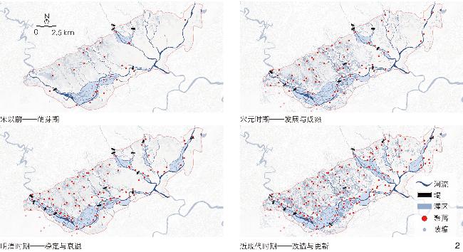
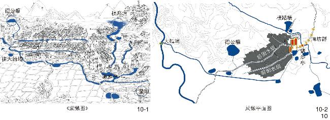
[Methods] The basic data of this research originates from the review, integration and combing of historical materials such as local records, monographs, historical opinion maps, old photos, and historical remote sensing images. Through the ArcGIS platform, the modern remote sensing images (2015), the aerial map of the area produced by the United States Geological Survey (USGS) in 1969 and water conservancy settlement elements are integrated into a unified coordinate system, a comprehensive database with multiple spatial scales, time dimensions, and data types is constructed, and subsequent analysis is carried out by a combination of mapping methods. On this basis, the research analyzes the spatial pattern of human settlements supported by water conservancy from the three perspectives of macro region, meso irrigation area and micro village, and analyzes the hydrological construction method of human settlements in typical irrigation areas in the 1970s by taking the Tangyue and Lyu’e irrigation areas as examples.
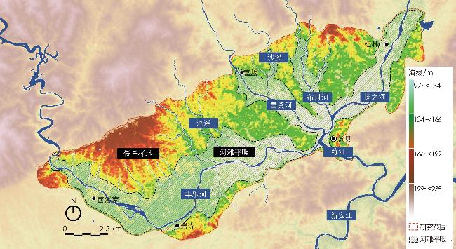
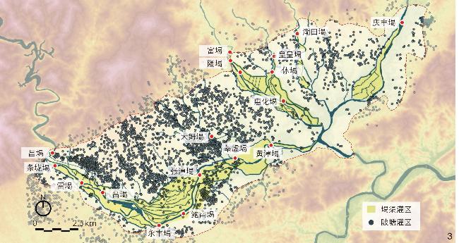
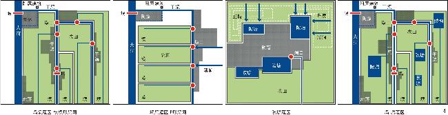
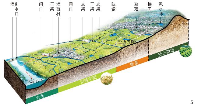
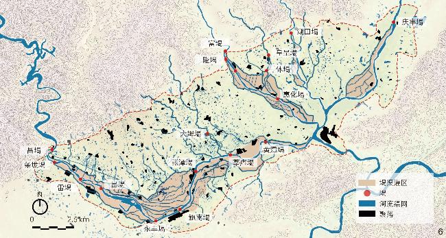
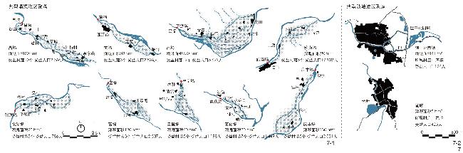
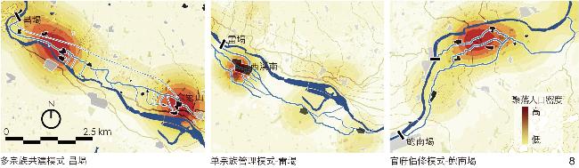
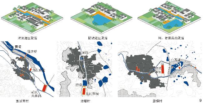
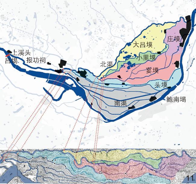
[Results] In the Shexiebei area, dammed canal (e’ba) and retention pond (“beitang”) together constitute the main form of irrigation and serve as the dominant factor in shaping the settlement pattern. At the macro level, dammed canals are located in the altitude of low flat river bank, while are located in the terrain of low mountain terraces, and different types of water conservancy projects vary in the degree of their support for local human settlements, which is significantly correlated with regional population distribution and, to a certain extent, reflects that the water conservancy of dammed canals can bring higher social organization benefits than that of retention ponds. At the meso level, the links between communities in the irrigation areas of dammed canals are more extensive and diversified, reflected as different management modes, such as single-clan dominance, multi-clan co-construction, and civil repair under government supervision, whereas the irrigation areas of retention ponds can hardly form a large-scale organization of water management due to the limited irrigation area and privatization of retention ponds. At the micro level, water conservancy facilities also have a profound impact on the site selection and construction of settlements; the layout of settlements based on retention ponds with pond as the nucleus, that of settlements based on dammed canals with canal as the axis, and that of mixed-type settlements with water as the vein are all affected by water conservancy, and regional village pattern is typically featured by building by water and living by water.
[Conclusion] For a long time, through the practice of water resource utilization and management, people have created the cultural wealth of water conservancy with rich historical connotations and regional characteristics, which constitutes the main content of the cultural value of water conservancy heritage. In addition to engineering entities, the values of agricultural and cultural landscapes derived from traditional water conservancy systems should also be emphasized. This research uses water conservancy as a clue to study the characteristics of settlements, demonstrates the supportive role of the element of water conservancy for traditional farming society at all scales, and provides a new approach and methodology for regional development dominated by water conservancy. In the ongoing process of rejuvenating traditional irrigation areas, leveraging water conservancy as a pivotal force that spurs regional paradigm shifts and economic vitality holds immense potential. By embracing water conservancy heritage and the distinctive farmland landscapes that are emblematic of the Shexibei area as tangible cornerstones, this research endeavors to not only preserve but also harness these assets for transformation. Furthermore, the seamless integration of intangible elements, encompassing rich historical narratives, cultural traditions, and the intricate web of social ties and heritage, offers a unique opportunity to enrich the narrative and texture of these landscapes.
Kai WANG , Wei JI , Wei GUO , Xiaolei HOU . Research on Traditional Settlement System Dominated by Water Conservancy in the Shexibei Basin, Huizhou[J]. Landscape Architecture, 2024 , 31(10) : 125 -132 . DOI: 10.3724/j.fjyl.202312220583
表1 歙西北地区不同管理模式下的堨渠灌区Tab. 1 Dammed canals irrigation areas under different management models in the Shexibei area |
| 管理模式 | 堨名 | 倡修主体 |
| 多宗族共建 | 昌堨 | 宋(960—1279年)余家山余氏与昌堨吴氏共建 |
| 富堨 | 宋元(960—1368年)沙溪凌姓与富堨汪姓共建 | |
| 皇呈堨 | 明(1368—1644年)沙溪、徐村合筑 | |
| 惠化堨 | 宋(960—1279年)沙溪、徐村等七姓村落合筑 | |
| 吕堨 | 梁大通元年(527年)堨田吕文达倡修 清康熙五十九年(1720年)郑氏独修 清乾隆九年(1744年)郑氏与潘氏共修 清嘉庆四年(1799年)郑、鲍、朱氏共修 清道光三十年(1850年)郑氏统领众人共修 | |
| 单宗族管理 | 条垅堨 | 明正德元年(1506年)西溪南吴氏倡修 |
| 雷堨 | 南宋祥兴元年(1278年)临河程氏倡修 | |
| 庆丰堨 | 明洪武元年(1368年)桂林洪氏倡修 | |
| 官府倡修 | 鲍南堨、张潭堨 | 东晋咸和二年(327年)新安太守鲍宏兴筑 清乾隆十九年(1754年)太守何达善疏筑 清乾隆五十三年(1788年)太守峻亮疏筑 清同治元年(1862年)太守刘传祺疏筑 |
| [1] |
安徽省黄山市水电局.徽州地区水利志[M].北京: 方志出版社, 1997: 10
Anhui Province Huangshan City Water and Electricity Bureau. Huizhou Area Water Conservancy Journal[M]. Beijing: Fangzhi Publishing House, 1997: 10
|
| [2] |
行龙. “水利社会史”探源: 兼论以水为中心的山西社会[J]. 山西大学学报(哲学社会科学版), 2008(1): 33-38.
XING L. A Probe into the Origin of the Social History of Water Conservancy: Concurrent Discussion on the Water-Centered Shanxi Society[J]. Journal of Shanxi University (Philosophy and Social Science Edition), 2008(1): 33-38.
|
| [3] |
鲁西奇.“水利社会”的形成: 以明清时期江汉平原的围垸为中心[J].中国经济史研究, 2013(2): 122-139, 172, 176.
LU X Q. The Making of Water Community in the Traditional China: Discussion Around the “Enclosed Embankment” in Jianghan Plain During Ming-Qing Period[J]. Researches in Chinese Economic History, 2013(2): 122-139, 172, 176.
|
| [4] |
王建革. 泾、浜发展与吴淞江流域的圩田水利(9—15世纪)[J]. 中国历史地理论丛, 2009, 24(2): 30-42.
WANG J G. The Development of Jin-Bang and the Wei-Field Irrigation in Wusong River Valley 9th-15th Century[J]. Journal of Chinese Historical Geography, 2009, 24(2): 30-42.
|
| [5] |
谢湜. 太湖以东的水利、水学与社会(12—14世纪)[J]. 中国历史地理论丛, 2011, 26(1): 17-31.
XIE S. Water Conservancy, Water Management Theories and Society in the Tai Lake Area (12th-14th Century)[J]. Journal of Chinese Historical Geography, 2011, 26(1): 17-31.
|
| [6] |
王向荣, 林箐. 国土景观视野下的中国传统山—水—田—城体系[J]. 风景园林, 2018, 25(9): 10-20.
WANG X R, LIN Q. Traditional Chinese Mountain-Water-Field-City System from the Perspective of Territorial Landscape[J]. Landscape Architecture, 2018, 25(9): 10-20.
|
| [7] |
何依, 陈晓梅. 宁波地区传统市镇空间的双重性及保护研究: 以东钱湖韩岭村为例[J]. 城市规划, 2018, 42(7): 93-101.
HE Y,CHEN X M. Research on the Duality and Conservations of Traditional Town Space in Ningbo: A Case Study of Hanling Village, Dongqian Lake Resort[J]. City Planning Review, 2018, 42(7): 93-101.
|
| [8] |
汪芳, 方勤, 袁广阔, 等. 流域文明与宜居城乡高质量发展[J]. 地理研究, 2023, 42(4): 895-916.
WANG F, FANG Q, YUAN G K, et al. River Basin Civilization and High-Quality Development of Its Livable Urban and Rural Areas[J]. Geographical Research, 2023, 42(4): 895-916.
|
| [9] |
郭巍, 侯晓蕾. 筑塘、围垦和定居: 萧绍圩区圩田景观分析[J]. 中国园林, 2016, 32(7): 41-48.
GUO W, HOU X L. Dyke, Reclamation and Settlement: Landscape Architectural Analysis of Polder Landscape in Xiaoshao Region[J]. Chinese Landscape Architecture, 2016, 32(7): 41-48.
|
| [10] |
丁廷楗, 赵吉士, 等.徽州府志[M].合肥: 黄山书社, 2010: 57-58
DING T J, ZHAO J S, et al. Huizhou Prefectural Records[M]. Hefei: Huangshan Publishing House, 2010: 57-58.
|
| [11] |
何东序, 汪尚宁.徽州府志[M].北京: 全国图书馆缩微文献复制中心, 1992.
HE D X, WANG S N. Huizhou Prefectural Records[M]. Beijing: China National Microfilming Center for Library Resources, 1992.
|
| [12] |
石国柱, 楼文钊.歙县志[M].[出版地不详: 出版者不详], 1937(民国二十六年).
SHI G Z, LOU W Z. Shexian Zhi[M]. [S.I.: s.n.], 1937 (Republic of China, 26th Year).
|
| [13] |
彭泽, 汪舜民.徽州府志[M]. 北京: 全国图书馆缩微文献复制中心, 1992.
PENG Z, WANG S M. Huizhou Prefectural Records[M]. Beijing: China National Microfilming Center for Library Resources, 1992.
|
| [14] |
陈杰.宋元以来徽州的宗族、聚落与地域社会[D].上海: 上海师范大学, 2017.
CHEN J. Clans, Settlements and Regional Society in Huizhou Since Song and Yuan[D]. Shanghai: Shanghai Normal University, 2017.
|
| [15] |
马步蟾.徽州府志[M].台北: 成文出版社, 1972.
MA B C. Huizhou Prefecture Zhi[M]. Taipei: Chen Wen Publishing Co., Ltd, 1972.
|
| [16] |
歙县地方志编纂委员会. 安徽省歙县水利志(内部资料)[R].[出版地不详: 出版者不详], 1987: 64
Shexian County Local Records Compilation Committee. Anhui Province Shexian County Water Conservancy Record (Internal Material)[M]. [S.I.: s.n.], 1987: 64.
|
| [17] |
歙县史志办公室.明万历·歙志[M].合肥: 黄山书社, 2014: 39.
Shexian County Historical Records Office. Ming Wanli: Shezhi[M]. Hefei: Huangshan Publishing House, 2014: 39.
|
| [18] |
歙县地名委员会办公室.安徽省歙县地名录[M] .歙县: [出版者不详], 1987.
Office of Shexian County Geographical Names Committee. Gazetteer of Shexian County, Anhui Province[M] . Shexian: [s.n.], 1987.
|
| [19] |
佚名. 昌堨源流志[M].[出版地不详: 出版者不详], 1869(清同治八年)
Anon. Chang Dam Source and Flow of Old Records[M]. [S.I.: s.n.], 1869 (Qing Tongzhi, 8th Year).
|
| [20] |
黄山市徽州区档案局.丰南志[M] .合肥: 黄山书社, 2018: 268.
Huangshan City Huizhou District Archives Bureau. Fengnan Zhi[M]. Hefei: Huangshan Publishing House, 2018: 268.
|
| [21] |
周溶. 祁门县志[M].台北: 成文出版社, 1975: 8.
ZHOU R. Qimen Xian Zhi[M]. Taipei: Chen Wen Publishing Co., Ltd, 1972: 8.
|
| [22] |
鲍琮.棠樾鲍氏宣忠堂支谱[M]. 北京: 全国图书馆缩微文献复制中心, 1992: 24
BAO C. Tangyue Bao’s Xuanzhongtang Branch Genealogy[M]. Beijing: China National Microfilming Center for Library Resources, 1992: 24.
|
| [23] |
赵华富. 歙县棠樾鲍氏宗族个案报告[J]. 江淮论坛, 1993(2): 8
ZHAO H F. A Case Report on the Bao Clan of Tangyue, Shexian County[J]. Jianghuai Tribune, 1993(2): 8
|
| [24] |
郑时辅.重开吕堨两堨记[M].[出版地不详: 出版者不详], 1858.
ZHENG S F. Record of Reconstructing the Two Dams of Lyu Dam[M]. [S.I.: s.n.], 1858.
|
| [25] |
余康.“山村型”社会与水利管理制度转型[D].上海: 华东师范大学, 2019.
YU K. “Mountainous Village Society” and the Transformation of Water Management[D]. Shanghai: East China Normal University, 2019.
|
| [26] |
吴媛媛. 明清时期徽州民间水利组织与地域社会: 以歙县西乡昌堨、吕堨为例[J]. 安徽大学学报(哲学社会科学版), 2013, 37(2): 104-111.
WU Y Y. Civil Water Conservancy Organizations and Regional Society in Huizhou During the Ming and Qing Dynasties: The Case of the Western Townships of Chang Dam and Lyu Dam in Shexian County[J]. Journal of Anhui University (Philosophy and Social Sciences Edition), 2013, 37(2): 104-111.
|
| [27] |
陈海鹰, 李向明, 李鹏, 等. 文化旅游视野下的水利遗产内涵、属性与价值研究[J]. 生态经济, 2019, 35(7): 141-147.
CHEN H Y, LI X M, LI P. et al. Connotation, Attribute and Value of Water Conservancy Heritage from the Perspective of Cultural Tourism[J]. Ecological Economy, 2019, 35(7): 141-147.
|
/
| 〈 |
|
〉 |