
Quality Characteristics and Construction Management Strategies of Wet Pond Habitat: A Case Study of the Pilot Chongqing Sponge City Project
|
ZHANG Jisheng gained his master degree in Southwest University, and is a staff in the Housing and Urban-Rural Development Committee of Shapingba District, Chongqing Municipality. His research focuses on sponge habitat monitoring and technology optimization |
|
LIU Jialin, Ph.D., is a professor in and deputy director of the Department of Landscape Architecture, College of Horticulture and Landscape Architecture, Southwest University. Her research focuses on sustainable design of green spaces, landscape performance assessment and optimization for stormwater management, and sponge habitat monitoring and technology optimization |
|
MENG Yao is a master student in the College of Horticulture and Landscape Architecture, Southwest University. Her research focuses on landscape performance evaluation and optimization of stormwater management |
|
ZHOU Jianfeng is deputy director (Grade 5 staff) of Chongqing Municipal Administrative Approval Service Center for Housing and Urban-Rural Development. His research focuses on urban and rural construction and management |
Received date: 2024-02-22
Revised date: 2024-08-05
Online published: 2025-12-16
Copyright
[Objective] Domestic sponge city construction has gradually entered the stage of refined evaluation and optimized construction. At present, domestic research on sponge habitats focuses on stormwater management and biodiversity benefits. Wet ponds in sponge facilities, as sponge habitats with standing water levels, are key habitat heterogeneity patches in urban green spaces with significant ecological service potential. This research aims to enhance the construction quality of wet pond habitat, monitor and identify problems in the quality of native wet pond habitats, and propose strategies to improve the quality of wet pond habitat, and promote the enhancement of the ecological service function of this key habitat.
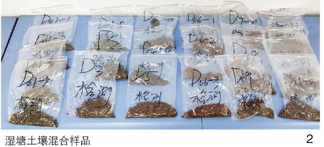
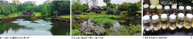
[Methods] Based on the completed wet pond facilities in the pilot sponge city area of Chongqing, this research monitored the quality of vegetation, soil, and water body in the wet pond habitat within the research area from 2021 to 2023. In this research, eleven representative wet pond facilities in Yuelai International Convention and Exhibition City are selected, and information such as plant species name, strain, and cover is recorded on site. Wet pond soil is surveyed and sampled to further clarify the physical properties and fertility quality characteristics thereof. Wet pond water samples are collected in sunny days and days with heavy rain or torrential rain, and water pollution indicators are measured. Vegetation habitat quality is assessed by the M-Godorn stability measurement method, soil habitat quality is assessed by the Nemero fertility index method, and water habitat quality by the Nemero pollution index method. Additionally, Kruskal-Wallis test is used to investigate whether there exists a significant difference in the quality of wet pond habitat between the construction land and the non-construction land, and Pearson analysis is used to investigate the correlation between the construction characteristics and water quality of wet pond.
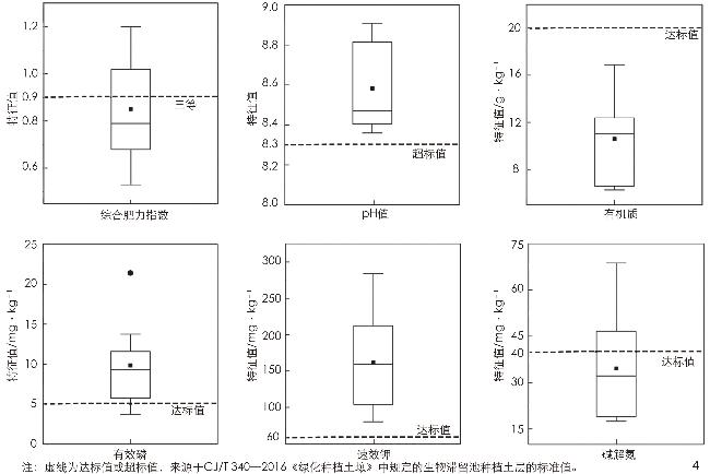
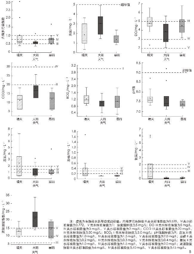
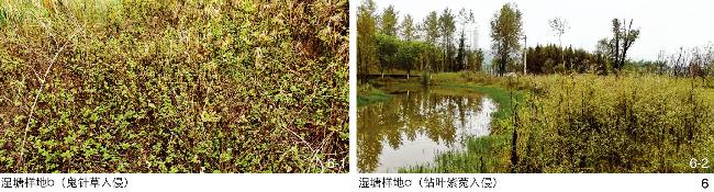
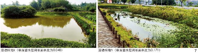
[Results] A total of 176 species of plants classified into 140 genera under 77 families are surveyed in the wet pond habitats, dominated by herbaceous species. Specifically, native species and invasive plant species account for 71.64% and 3.41% respectively, 7 plants belong to Class I invasive species with very strong invasibility, and the average cover of invasive plants in each wet pond accounts for 7.07%. The Euclidean distance range for plant community stability in wet ponds is 17.58 – 27.00, and all wet ponds are featured by a low level of plant community stability. Plant community stability and invasive plant cover are significantly higher in urbanized area than non-urbanized area. The wet pond soil has serious compaction problems with a mean value of 1.445 g/cm3. 50% of the soil samples have a saturated infiltration rate of 6.604 mm/h, indicating poor infiltration performance. The composite fertility index of the soil samples ranges from 0.532 to 1.198, indicating poor fertility. The soil is alkaline overall, with low organic matter content, sufficient effective phosphorus content, sufficient quick-acting potassium content, and insufficient hydrolysable nitrogen content. During the monitoring period, the Nemero pollution index of water body ranges from 1.087 to 3.757, the overall water quality is good enough to meet the class V water standard, except for wet ponds g and k. In addition, each wet pond is featured by good water body turbidity, with NTU, DO, COD and COD5 being up to standard, and pH value in the middle alkaline range. The water body habit is out of standard overall in terms of permanganate, with a few water bodies being out of standard in terms of TN, TP, and NH3-N. The perimeter-area ratio of wet pond is significantly negatively correlated with the Nemero pollution index (r=–0.665, p<0.05). The narrower and longer a wet pond, the lower the pollution index. The depth of wet pond is not significantly correlated with the Nemero pollution index, but data show that the depth of wet ponds with better water quality is mostly in the range of 0.55 – 1.45 m. Pre-positioned ponds can significantly clarify various pollution indexes regarding the water body in wet pond, especially in times of heavy rain.
[Conclusion] The quality of wet pond habitat can be improved through rational design, construction and management. In terms of design and construction, it is possible to add a front pond, increase the length – width ratio of wet pond, separate the relative position between the inlet and outlet of wet pond, and control the depth of wet pond at 0.6 – 1.2 m. In terms of management and maintenance, it is possible to reduce the frequency of weed management on construction sites, eliminate invasive species, and strengthen supervision to avoid soil trampling. This research can enrich the content of habitat monitoring in sponge cities, and provide an important reference for the refined construction and management of sponge cities.
Key words: sponge city; sponge habitat; habitat monitoring; wet pond; habitat construction
Jisheng ZHANG , Jialin LIU , Yao MENG , Jianfeng ZHOU . Quality Characteristics and Construction Management Strategies of Wet Pond Habitat: A Case Study of the Pilot Chongqing Sponge City Project[J]. Landscape Architecture, 2024 , 31(9) : 76 -85 . DOI: 10.3724/j.fjyl.202402220100
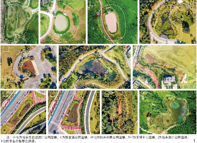
表1 悦来国际会展城湿塘样地信息Tab. 1 Information about wet pond sample plots in Yuelai International Convention and Exhibition City |
| 样地所在位置 | 样地编号 | 样地面积/m2 | 有无前置塘 | 平均水深/m | 表面蓄水层 周长面积比 | 绿地类型 |
| 悦来生态城 滨江公园 | a | 30 087 | 有 | 0.75 | 0.266 | 风景游憩绿地(EG1) |
| b | 1 622 | 无 | 1.88 | 0.178 | ||
| 张家溪公园 | c | 1 879 | 有 | 1.24 | 0.189 | 公园绿地(G1) |
| 悦来会展公园 | d | 4 233 | 有 | 0.55 | 0.134 | |
| e | 514 | 无 | 0.62 | 0.258 | ||
| f | 11 503 | 有 | 1.45 | 0.062 | ||
| g | 3 317 | 有 | 0.30 | 0.252 | ||
| 国博中心 | h | 1 559 | 无 | 1.07 | 0.171 | 文化设施用地附属绿地(AG) |
| i | 1 326 | 无 | 1.40 | 0.214 | ||
| 悦来滨江公园 | j | 2 936 | 有 | 0.72 | 0.389 | 风景游憩绿地(EG1) |
| 悦来生态保育地 | k | 25 843 | 有 | 1.87 | 0.048 | 防护绿地(G2) |
表2 土壤肥力等级划分Tab. 2 Classification of soil fertility levels |
| 肥力等级 | 肥力评价 | 综合肥力指数范围 |
| 一等 | 很肥沃 | ≥2.7 |
| 二等 | 肥沃 | 1.8~<2.7 |
| 三等 | 一般(中等) | 0.9~<1.8 |
| 四等 | 贫瘠 | <0.9 |
表3 依据内梅罗污染指数的水质级别划分Tab. 3 Water quality grades classified by the Nemero pollution index |
| 水质级别 | 内梅罗污染指数范围 |
| Ⅰ | ≤0.200 |
| Ⅱ | >0.200~0.336 |
| Ⅲ | >0.336~0.520 |
| Ⅳ | >0.520~0.772 |
| Ⅴ | >0.772~1.000 |
表4 湿塘植物群落稳定性Tab. 4 Stability of plant community in wet pond |
| 用地性质 | 样地 | 拟合曲线 | 交点坐标 | 拟合度(R 2) | 欧氏距离 |
| 注:表中**表示极显著相关。 | |||||
| 非建设用地 | a | y=−1.22 561x 2+2.03 694x+0.12 844 | (33.13,66.87) | 0.984** | 18.57 |
| b | y=−1.19 201x 2+2.03 744x+0.09 899 | (35.53,64.47) | 0.988** | 20.18 | |
| g | y=−1.06 439x 2+1.80 252x+0.20 317 | (31.66,68.34) | 0.973** | 17.58 | |
| 建设用地 | c | y=−0.9 1801x 2+1.67 717x+0.18 720 | (34.42,65.68) | 0.978** | 20.32 |
| d | y=−0.91 897x 2+1.67 181x+0.20 007 | (33.89,66.11) | 0.985** | 19.64 | |
| e | y=−0.76 428x 2+1.62 804x+0.10 406 | (38.37,61.63) | 0.993** | 25.98 | |
| f | y=−1.11 822x 2+1.91 621x+0.13 991 | (33.93,66.07) | 0.979** | 19.66 | |
| g | y=−0.98 744x 2+1.81 451x+0.12 486 | (35.52,64.47) | 0.982** | 21.96 | |
| h | y=−0.95 816x 2+1.87 483x+0.04 794 | (37.91,62.09) | 0.995** | 25.33 | |
| i | y=−0.83 914x 2+1.77 902x+0.04 199 | (39.09,60.91) | 0.997** | 27.00 | |
| k | y=−1.14 337x 2+1.97 798x+0.11 355 | (34.28,65.72) | 0.987** | 20.19 | |
文中图表均由作者拍摄或绘制。
| [1] |
住房和城乡建设部办公厅.住房和城乡建设部办公厅关于进一步明确海绵城市建设工作有关要求的通知[EB/OL].(2022-04-18)[2023-08-12]. https://www.gov.cn/zhengce/zhengceku/2022-04/29/content_5687999.htm.
General Office of the Ministry of Housing and Urban-Rural Development. Notice of the General Office of the Ministry of Housing and Urban-Rural Development on Further Clarifying the Relevant Requirements for Sponge City Construction Work[EB/OL]. (2022-04-18)[2023-08-12]. https://www.gov.cn/zhengce/zhengceku/2022-04/29/content_5687999.htm.
|
| [2] |
财政部办公厅, 住房城乡建设部办公厅, 水利部办公厅.关于开展“十四五”第三批系统化全域推进海绵城市建设示范工作的通知[EB/OL].(2023-04-26)[2023-08-12]. http://jjs.mof.gov.cn/tongzhigonggao/202304/t20230427_3881609.htm.
Ministry of Finance of the People’s Republic of China, General Office of the Ministry of Housing and Urban-Rural Development, Ministry of Water Resources of the People’s Republic of China. Ministry of Housing and Urban-Rural Development on the Issuance of the National Garden City Declaration and Selection of Management Methods Notice on the “14th Five-Year Plan” the Third Batch of Systematization of the Whole Region to Promote Sponge City Construction Demonstration Work Notice[EB/OL]. (2023-04-26)[2023-08-12]. http://jjs.mof.gov.cn/tongzhigonggao/202304/t20230427_3881609.htm.
|
| [3] |
刘家琳, 刘兆莉, 张蕊. 重庆示范性海绵型住区海绵系统长期水文-成本综合绩效优化[J]. 风景园林, 2024, 31(2): 78-86.
LIU J L, LIU Z L, ZHANG R. Optimization of Long-Term Hydrological-Cost Integrated Performance of Sponge System in Chongqing Demonstration Sponge-Type Settlement[J]. Landscape Architecture, 2024, 31(2): 78-86.
|
| [4] |
成玉宁, 谢明坤. 相反相成: 基于数字技术的城市道路海绵系统实践: 以南京天保街生态路为例[J]. 中国园林, 2017, 33(10): 5-13.
CHENG Y N, XIE M K. Being Both Opposite and Complementary: Urban Road Sponge System Practice Based on Digital Technology: Taking Nanjing Tianbao Street Ecological Road as the Example[J]. Chinese Landscape Architecture, 2017, 33(10): 5-13.
|
| [5] |
刘家琳, 李武肸, 彭子岳, 等. 基于水文-成本综合绩效的山地公园雨洪管理景观系统策略研究[J]. 风景园林, 2021, 28(7): 90-96.
LIU J L, LI W X, PENG Z Y, et al. Research on Stormwater Management Landscape System Strategies in Mountainous Urban Parks Based on the Hydrological Cost Comprehensive Effectiveness[J]. Landscape Architecture, 2021, 28(7): 90-96.
|
| [6] |
刘晖, 李仓拴, 王晶懋. 低影响开发引导下的生境与植物群落景观建构[J]. 中国园林, 2019, 35(10): 13-18.
LIU H, LI C S, WANG J M. Construction of Habitat-Site and Plant Community Landscape Under the Guidance of Low-Impact Development[J]. Chinese Landscape Architecture, 2019, 35(10): 13-18.
|
| [7] |
陈晓菲. 基于生物多样性的海绵城市景观途径探讨[J]. 生态经济, 2019, 35(10): 13-18.
CHEN X F. Based on Biological Diversity to Explore the Design Method of Sponge Urban Landscape[J]. Ecological Economy, 2019, 35(10): 13-18.
|
| [8] |
吕娜, 王小璘. 生态水质净化技术在城市湿地公园设计中的应用以长广溪国家城市湿地公园一期景观设计为例[J]. 风景园林, 2013(5): 92-98.
LYU N, WANG X L. Application of Ecological Water Purification Technology in Urban Wetland Park Design: Taking the Landscape Design of Phase I of Changguangxi National Urban Wetland Park as an Example[J]. Landscape Architecture, 2013(5): 92-98.
|
| [9] |
陈珏洁, 郭雨蕊, 阳佩琳, 等. 塘类海绵生境鸟类多样性特征及其影响因素研究[J]. 中国园林, 2023, 39(11): 111-117.
CHEN J J, GUO Y R, YANG P L, et al. Study on the Diversity Characteristics and Influencing Factors of Birds in Pond Sponge Habitats[J]. Chinese Landscape Architecture, 2023, 39(11): 111-117.
|
| [10] |
HASSALL C, HOLLINSHEAD J, HULL A. Environmental Correlates of Plant and Invertebrate Species Richness in Ponds[J]. Biodiversity and Conservation, 2011, 20: 3189-3222.
|
| [11] |
RIGUCCIO L, D’URSO S, SCHIPPA G, et al. Green Urban Planning Strategies for Climate Change Resilience of the Catania Metropolitan Area[J]. Acta Horticulturae, 2018(1215): 207-212.
|
| [12] |
PARTRIDGE D R, CLARK J A. Urban Green Roofs Provide Habitat for Migrating and Breeding Birds and Their Arthropod Prey[J]. PloS one, 2018, 13(8): e0202298
|
| [13] |
YANG B, LEE D. Urban Green Space Arrangement for an Optimal Landscape Planning Strategy for Runoff Reduction[J]. Land, 2021, 10(9): 897
|
| [14] |
CHIANDET A S, XENOPOULOS M A. Landscape and Morphometric Controls on Water Quality in Stormwater Management Ponds[J]. Urban Ecosystems, 2016, 19: 1645-1663.
|
| [15] |
FILAZZOLA A, SHRESTHA N, MACIVOR J S. The Contribution of Constructed Green Infrastructure to Urban Biodiversity: A Synthesis and Meta-Analysis[J]. Journal of Applied Ecology, 2019, 56(9): 2131-2143.
|
| [16] |
STEPHANSEN D A, NIELSEN A H, HVITVED-JACOBSEN T, et al. Invertebrates in Stormwater Wet Detention Ponds: Sediment Accumulation and Bioaccumulation of Heavy Metals Have No Effect on Biodiversity and Community Structure[J]. Science of the Total Environment, 2016, 566: 1579-1587.
|
| [17] |
SØNDERUP M J, EGEMOSE S, HOFFMANN C C, et al. Modeling Phosphorus Removal in Wet Ponds with Filter Zones Containing Sand or Crushed Concrete[J]. Ecological Engineering, 2014, 66: 52-62.
|
| [18] |
KEYVANFAR A, SHAFAGHAT A, ISMAIL N, et al. Multifunctional Retention Pond for Stormwater Management: A Decision-Support Model Using Analytical Network Process (ANP) and Global Sensitivity Analysis (GSA)[J]. Ecological Indicators. 2021, 124: 107317.
|
| [19] |
MAXWELL B, WINTER D, BIRGAND F. Floating Treatment Wetland Retrofit in a Stormwater Wet Pond Provides Limited Water Quality Improvements[J]. Ecological Engineering, 2020, 149: 105784
|
| [20] |
重庆市渝北区人民政府.重庆市渝北区人民政府关于印发重庆市渝北区高标准农田建设规划(2021—2030年)的通知[EB/OL].(2022-08-17)[2023-08-12]. http://www.ybq.gov.cn/zwgk_263/zcwj/qtwj/202208/t20220822_11025649.html?eqid=ba71e7bf000042c8000000066440fbf5.
Yubei District People’s Government of Chongqing Municipality. Circular of the People’s Government of Yubei District of Chongqing Municipality on the Issuance of the High-Standard Farmland Construction Plan of Yubei District of Chongqing Municipality (2021−2030)[EB/OL]. (2022-08-17)[2023-08-12]. http://www.ybq.gov.cn/zwgk_263/zcwj/qtwj/202208/t20220822_11025649.html?eqid=ba71e7bf000042c8000000066440fbf5.
|
| [21] |
陈钧.作为全国首批16个“海绵城市”建设试点之一, 悦来3月将迎大考: 悦来试点经验看过来[N/OL].重庆日报, 2018-02-05[2023-08-12]. https://app.cqrb.cn/cover/2018-02-05/18077.html.
CHEN J. As the Country’s First 16 “Sponge City” Construction of One of the Pilot, Yuelai March Will Meet the Big Test: Yuelai Pilot Experience to See Over[N/OL]. CHONGQING DAILY, 2018-02-05[2023-08-12]. https://app.cqrb.cn/cover/2018-02-05/18077.html.
|
| [22] |
中国科学院中国植物志编辑委员会.中国植物志[M].北京: 科学出版社, 1993.
Chinese Academy of Sciences Editorial Committee of Flora of China. Flora of China[M]. Beijing: Science Press, 1993.
|
| [23] |
胡迅, 杨永川, 靳程, 等. 不同乡土植物概念下的居住区乡土植物应用概况: 以重庆主城区为例[J]. 中国园林, 2022, 38(10): 26-31.
HU X, YANG Y C, JIN C, et al. Application of Native Plants in Residences Under Different Concepts of Native Plants: A Case Study of Chongqing Main Urban Area[J]. Chinese Landscape Architecture, 2022, 38(10): 26-31.
|
| [24] |
CERVELLI E W, LUNDHOLM J T, DU X. Spontaneous Urban Vegetation and Habitat Heterogeneity in Xi’an, China[J]. Landscape and Urban Planning, 2013, 120: 25-33.
|
| [25] |
中华人民共和国住房和城乡建设部.绿化种植土壤标准: CJ/T 340—2016[S].北京: 中国标准出版社, 2016.
Ministry of Housing and Urban-Rural Development of the People’s Republic of China. Planting Soil for Greening Standards: CJ/T 340—2016[S]. Beijing: Standards Press of China, 2016
|
| [26] |
朱本国, 王丽娟, 胡艳燕, 等. 重庆城市绿地土壤质量现状分析与改良建议[J]. 现代园艺, 2020, 43(15): 30-32.
ZHU B G, WANG L J, HU Y Y, et al. Analysis of the Current Status of Soil Quality in Chongqing Urban Green Spaces and Recommendations for Improvement[J]. Contemporary Horticulture, 2020, 43(15): 30-32.
|
| [27] |
WHITING D, CARD A, WILSON C, et al. Estimating Soil Texture[M]. Fort Collins: Colorado State University Extension Publication, 2014.
|
| [28] |
中华人民共和国国家环境保护总局.地表水环境质量标准: GB 3838—2002[S].北京: 中国标准出版社, 2002.
State Environmental Protection Administration of the People’s Republic of China. Surface Water Environmental Quality Standards: GB 3838—2002[S]. Beijing: China Standards Publishing House, 2002.
|
| [29] |
张琳, 陆兆华, 唐思易, 等. 露天煤矿排土场边坡植被组成特征及其群落稳定性评价[J]. 生态学报, 2021, 41(14): 5764-5774.
ZHANG L, LU Z H, TANG S Y, et al. Vegetation Composition Characteristics and Community Stability Evaluation of Open-Pit Coal Mine Waste Dump Slopes[J]. Journal of Ecology, 2021, 41(14): 5764-5774.
|
| [30] |
李明娟, 赵娟娟, 江南, 等. 深圳近海公园植物群落结构特征及其与景观格局的相关性[J]. 生态学报, 2021, 41(22): 8732-8745.
LI M J, ZHAO J J, JIANG N, et al. Characteristics of Plant Community Structure and Its Relationship with Landscape Pattern in Shenzhen Offshore Parks[J]. Acta Ecologica Sinica, 2021, 41(22): 8732-8745.
|
| [31] |
LIU J, SLIK F. Are Street Trees Friendly to Biodiversity?[J]. Landscape and Urban Planning, 2022, 218: 104304
|
| [32] |
李明娟, 赵娟娟, 刘时彦, 等. 山地城市公园植物群落功能多样性与物种多样性研究: 以重庆市主城区为例[J]. 中国园林, 2021, 37(2): 124-129.
LI M J, ZHAO J J, LIU S Y, et al. Study on the Functional Diversity and the Species Diversity of Plant Communities in Mountain City Parks: A Case Study of the Main Urban Area of Chongqing[J]. Chinese Landscape Architecture, 2021, 37(2): 124-129.
|
| [33] |
重庆市城市管理局.重庆市城市园林绿化条例[EB/OL].(2021-10-18)[2023-08-12]. http://cgj.cq.gov.cn/zwgk_173/fdzdgknr/lzyj/dfxfg/202110/t20211018_9816419.html.
Chongqing City Administration Bureau. Chongqing Urban Landscaping Regulations[EB/OL]. (2021-10-18)[2023-08-12]. http://cgj.cq.gov.cn/zwgk_173/fdzdgknr/lzyj/dfxfg/202110/t20211018_9816419.html.
|
| [34] |
中华人民共和国住房和城乡建设部.住房和城乡建设部关于印发国家园林城市申报与评选管理办法的通知[EB/OL].(2022-01-06)[2023-08-12]. https://www.mohurd.gov.cn/gongkai/zhengce/zhengcefilelib/202201/20220114_764128.html.
Ministry of Housing and Urban-Rural Development of the People’s Republic of China. Ministry of Housing and Urban-Rural Development on the Issuance of National Garden City Declaration and Selection of Management Measures Notice[EB/OL]. (2022-01-06)[2023-08-12]. https://www.mohurd.gov.cn/gongkai/zhengce/zhengcefilelib/202201/20220114_764128.html.
|
| [35] |
戴子云, 隋静轩, 许蕊, 等. 北京城市绿地土壤水分入渗性能研究[J]. 中国园林, 2019, 35(6): 105-108.
DAI Z Y, SUI J X, XU R, et al. Study on Soil Water Infiltration in Different Urban Green Space in Beijing[J]. Chinese Landscape Architecture, 2019, 35(6): 105-108.
|
| [36] |
伍海兵, 张青青, 梁晶. 城市绿地土壤肥力质量综合评价方法初探[J]. 土壤通报, 2020, 51(4): 795-800.
WU H B, ZHANG Q Q, LIANG J. A Comprehensive Evaluation Method of Soil Fertility Quality in Urban Green Space[J]. Chinese Journal of Soil Science, 2020, 51(4): 795-800.
|
| [37] |
全国土壤普查办公室.中国土壤[M].北京: 中国农业出版社, 1998.
National Soil Census Office. Soil in China[M]. Beijing: China Agriculture Press, 1998.
|
| [38] |
吴喜军, 董颖, 张亚宁. 改进的内梅罗污染指数法在黄河干流水质评价中的应用[J]. 节水灌溉, 2018(10): 51-53.
WU X J, DONG Y, ZHANG Y N. Application of Improved Nemerow Pollution Index Method in Water Quality Evaluation of Yellow River[J]. Water Saving Irrigation, 2018(10): 51-53.
|
| [39] |
中华人民共和国国家质量监督检验检疫总局.城市污水再生利用 景观环境用水水质: GB/T 18921—2002[S].北京: 中国标准出版社, 2002.
General Administration of Quality Supervision, Inspection and Quarantine of the People’s Republic of China. Urban Wastewater Recycling and Landscape Environment Water Quality: GB/T 18921—2002[S]. Beijing: China Standards Press, 2002.
|
| [40] |
龙佳, 王思思, 冯梦珂. 北京市低影响开发设施植物应用现状与评价优化[J]. 环境工程, 2020, 38(4): 89-95.
LONG J, WANG S S, FENG M K. Application Status and Evaluation Optimization of the Plans in Beijing LID Facilities[J]. Environmental Engineering, 2020, 38(4): 89-95.
|
| [41] |
高红娟, 史正军, 徐艳, 等. 广东地区公园绿地海绵设施植物应用研究[J]. 亚热带植物科学, 2020, 49(4): 292-298.
GAO H J, SHI Z J, XU Y, et al. Analysis of Plant Application to Low Impact Development Facilities of Park Green Space in Guangdong[J]. Subtropical Plant Science, 2020, 49(4): 292-298.
|
| [42] |
LI X P, FAN S X, GUAN J H, et al. Diversity and Influencing Factors on Spontaneous Plant Distribution in Beijing Olympic Forest Park[J]. Landscape and Urban Planning, 2019, 181: 157-168.
|
| [43] |
SINCLAIR J S, REISINGER A J, BEAN E, et al. Stormwater Ponds: An Overlooked But Plentiful Urban Designer Ecosystem Provides Invasive Plant Habitat in a Subtropical Region (Florida, USA)[J]. Science of the Total Environment, 2020, 711: 135133
|
| [44] |
SINCLAIR J S, ADAMS C R, REISINGER A J, et al. High Similarity and Management-Driven Differences in the Traits of a Diverse Pool of Invasive Stormwater Pond Plants[J]. Landscape and Urban Planning, 2020, 201: 103839
|
| [45] |
CALKINS M. The Sustainable Sites Handbook: A Complete Guide to the Principles, Strategies, and Best Practices for Sustainable Landscapes[M]. New York: John Wiley & Sons, 2012: 143-152.
|
| [46] |
YANG Y, XU B, YU Q, et al. Distribution Pattern and Factors Influencing Spontaneous Plant Diversity in Different Wetland Habitats[J]. Forests, 2022, 13(10): 1678
|
| [47] |
LYKHOLAT Y, KHROMYKH N, DIDUR O, et al. The Study of Transformed Herbaceous Vegetation in the Area Flooded Due to Coal Mine Workings[J]. Ekológia (Bratislava), 2021, 40(3): 222-229.
|
| [48] |
张梦园, 李坤, 邢小艺, 等. 北京温榆河-北运河生态廊道自生植物多样性对城市化的响应[J]. 生态学报, 2022, 42(7): 2582-2592.
ZHANG M Y, LI K, XING X Y, et al. Responses of Spontaneous Plant Diversity to Urbanization in Wenyu River-North Canal Ecological Corridor, Beijing[J]. Acta Ecologica Sinica, 2022, 42(7): 2582-2592.
|
| [49] |
JIANG L, PU Z. Different Effects of Species Diversity on Temporal Stability in Single-Trophic and Multitrophic Communities[J]. The American Naturalist, 2009, 174(5): 651-659.
|
| [50] |
REISINGER T W, SIMMONS G L, POPE P E. The Impact of Timber Harvesting on Soil Properties and Seedling Growth in the South[J]. Southern Journal of Applied Forestry, 1988, 12(1): 58-67.
|
| [51] |
伍海兵, 梁晶, 蔡永立, 等. 人工湖沿岸带绿地土壤质量特征研究: 以上海滴水湖沿岸带为例[J]. 中国园林, 2022, 38(2): 110-114.
WU H B, LIANG J, CAI Y L, et al. Study on Soil Quality Characteristics of Green Space Along the Coast of Artificial Lake: Taking the Coastal Zone of Shanghai Dishui Lake as an Example[J]. Chinese Landscape Architecture, 2022, 38(2): 110-114.
|
| [52] |
YANG J L, ZHANG G L. Water Infiltration in Urban Soils and Its Effects on the Quantity and Quality of Runoff[J]. Journal of Soils and Sediments, 2011, 11: 751-761.
|
| [53] |
陈洪.重庆市主城区城市绿地土壤质量评价研究[D].重庆: 西南大学, 2013.
CHEN H. Assessment of Soil Quality for Urban Green Spaces in Chongqing City[D]. Chongqing: Southwest University, 2013.
|
| [54] |
LAN T, GUO S W, HAN J W, et al. Evaluation of Physical Properties of Typical Urban Green Space Soils in Binhai Area, Tianjin, China[J]. Urban Forestry & Urban Greening, 2019, 44: 126430
|
| [55] |
黄晖, 毕舒贻, 字肖萌, 等. 深圳城市绿地土壤入渗性能及影响因素研究[J]. 中国农学通报, 2020, 36(14): 74-79.
HUANG H, BI S Y, ZI X M, et al. Urban Green Spaces in Shenzhen: Soil Infiltration Capacity and Its Influencing Factors[J]. Chinese Agricultural Science Bulletin, 2020, 36(14): 74-79.
|
| [56] |
REYNOLDS W D, YANG X M, DRURY C F, et al. Effects of Selected Conditioners and Tillage on the Physical Quality of a Clay Loam Soil[J]. Canadian Journal of Soil Science, 2003, 83(4): 381-393.
|
| [57] |
WANG D, BAI J, WANG W, et al. Comprehensive Assessment of Soil Quality for Different Wetlands in a Chinese Delta[J]. Land Degradation & Development, 2018, 29(10): 3783-3794.
|
| [58] |
ZHANG J, LI S, SUN X, et al. Sustainability of Urban Soil Management: Analysis of Soil Physicochemical Properties and Bacterial Community Structure Under Different Green Space Types[J]. Sustainability, 2019, 11(5): 1395
|
| [59] |
LI J, ZHANG Q, LI Y, et al. Impact of Mowing Management on Nitrogen Mineralization Rate and Fungal and Bacterial Communities in a Semiarid Grassland Ecosystem[J]. Journal of Soils and Sediments, 2017, 17: 1715-1726.
|
| [60] |
白家云, 杨丽军, 胡艳燕, 等. 重庆市主要公园中景观水体水质调查分析[J]. 绿色科技, 2018(20): 84-85.
BAI J Y, YANG L J, HU Y Y, et al. Survey and Analysis of Water Quality of Landscape Water Bodies in Major Parks in Chongqing Municipality[J]. Journal of Green Science and Technology, 2018(20): 84-85.
|
| [61] |
ÇELIK F. Investigating Urban Open-Green Spaces in Konya Through Ecological Quality Criteria[J]. Oxidation Communications, 2016, 39(1-II): 521
|
| [62] |
SONG K, XENOPOULOS M A, BUTTLE J M, et al. Thermal Stratification Patterns in Urban Ponds and Their Relationships with Vertical Nutrient Gradients[J]. Journal of Environmental Management, 2013, 127: 317-323.
|
| [63] |
THARP R. Ecological Stormwater Management: Analysis of Design Components to Improve Understanding and Performance of Stormwater Retention Ponds[D]. Burlington: University of Vermont, 2018.
|
| [64] |
侯岳, 王畅, 李运远. 基于生物多样性的人工湿地植物群落构建途径[J]. 城市建筑, 2023, 20(3): 202-205.
HOU Y, WANG C, LI Y Y. Approach to Constructing Plant Communities in Artificial Wetlands Based on Biodiversity[J]. Urban Architecture, 2023, 20(3): 202-205.
|
/
| 〈 |
|
〉 |