
Evaluation of the Potential for Renewing Urban Vacant Land into Green Infrastructure
|
LU Ming, Ph.D., is a professor in the School of Architecture and Design, Harbin Institute of Technology. Her research focuses on sustainable development of urban and rural ecosystems |
|
JIN Meicen is a master student in the School of Architecture and Design, Harbin Institute of Technology. Her research focuses on sustainable development of urban and rural ecosystems |
|
ZHANG Yan is a Ph.D. candidate in the School of Architecture and Design, Harbin Institute of Technology. Her research focuses on sustainable development of urban and rural ecosystems |
Received date: 2023-07-07
Online published: 2025-12-15
Copyright
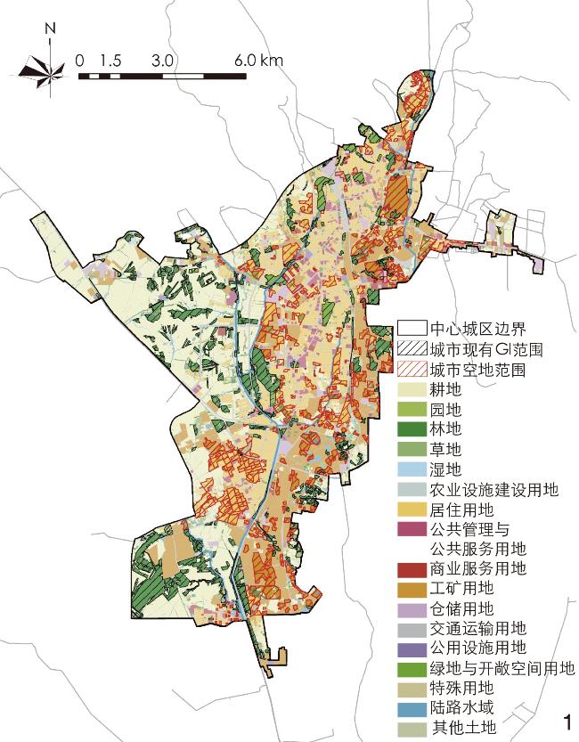
[Objective] The most significant problem caused by urban shrinkage is the phenomenon of large-scale urban spatial vacancy, which has generated a large quantity of vacant lands, buildings, and infrastructure in cities. As “gray area” in urban space, vacant land is prone to arouse waterlogging and rainwater siltation, which will not only decrease the quality of urban space, affect cityscape and result in landscape fragmentation, but also generate economic and social problems. Indeed, the renewal of vacant land into green infrastructure (GI) has been proven to be an effective way to alleviate negative effects caused by urban shrinkage. At present, there exists a research gap on the evaluation of the potential for renewal of vacant land from the perspective of both function and structure. It is of great scientific significance to explore the potential for renewing urban vacant land into GI from this perspective to realize the high-quality development of shrinking city.
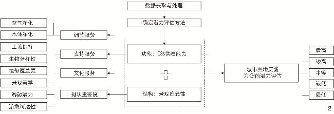
[Methods] Based on the characteristics of GI, urban vacant land is evaluated from the perspective of both function and structure. At the functional level, ecosystem services are selected as the evaluation indicator. While at the structural level, landscape connectivity is selected as the evaluation indicator. The potential for renewing urban vacant land into GI is calculated by equally weighted overlap analysis. This research selects 2 regulation services (air purification and water purification), 3 support services (soil conservation, biodiversity, and vegetation coverage), and 3 cultural services (landscape aesthetics, recreational potential, and recreational accessibility) as main ecosystem services evaluated targeting the renewal potential of urban vacant land. Also, this research selects patch importance as an indicator of landscape connectivity. Finally, ArcGIS 10.8 is used for calculations to reflect the spatial distribution and potential evaluation results.
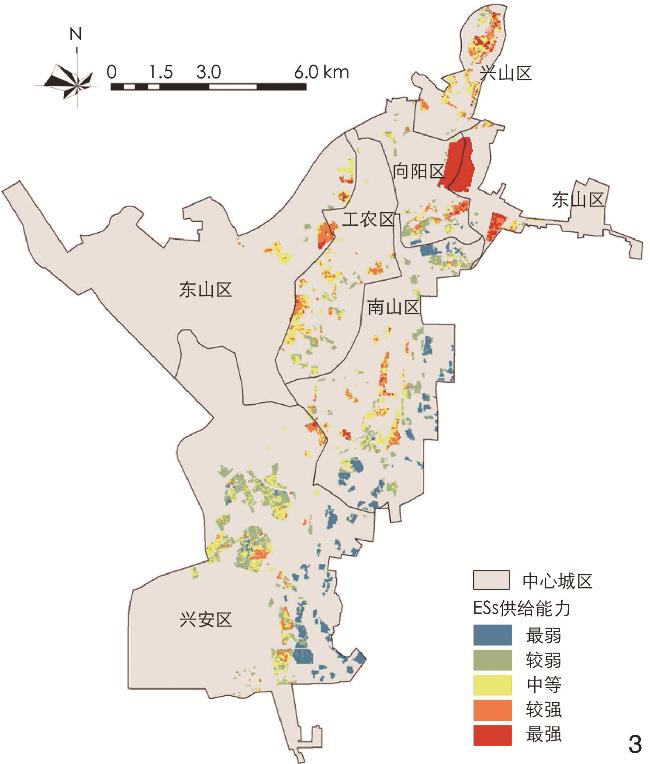
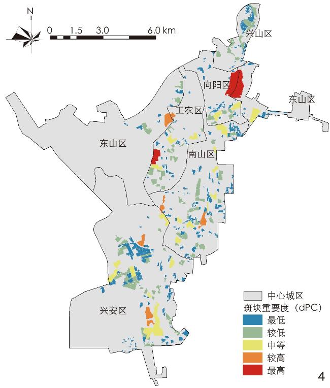
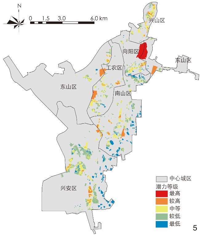
[Results] In terms of functionality, the overall results show a distribution trend of being high in the north and low in the south. Almost all areas with high ecosystem service supply are lands with minimal human activity damage, such as forests and grasslands; meanwhile, areas with low ecosystem service supply are mostly the lands left behind under the most severe impact of human activities. The vacant lands with high ecosystem service supply account for 26.47% of the total. In terms of structure, the overall landscape connectivity of vacant lands in the central urban area of Hegang is not high, with only a few vacant lands being of medium or higher patch importance. Vacant lands with high connectivity are distributed scatteredly in each district, which account for 16.26% of the total. There exists a correlation in spatial distribution between the evaluation results of the renewal potential of the vacant lands and the evaluation results of function and structure in the central urban area of Hegang. The renewal potential of the vacant lands is not high overall. Vacant lands with high potential only account for 22.19% which almost owned large area in each district. The spatial distribution pattern of the potential evaluation with respect to the renewal of urban vacant land into GI is similar to that of the functional evaluation, both showing a pattern of being high in the old urban area and gradually decreasing from urban center to the suburb. Most of the vacant lands in the central urban area of Hegang are of low potential for renewal into GI, with the vacant lands with high potential being distributed scatteredly in each district. There is only one vacant land with the highest renewal potential, located at the junction of Xiangyang District and Dongshan District in the northern part of the central urban area with an area of 105.39 hectares, accounting for 7.87% of the total. Vacant lands with high renewal potential are also quite few, with a total area of 191.88 hectares, accounting for 14.32% of the total.
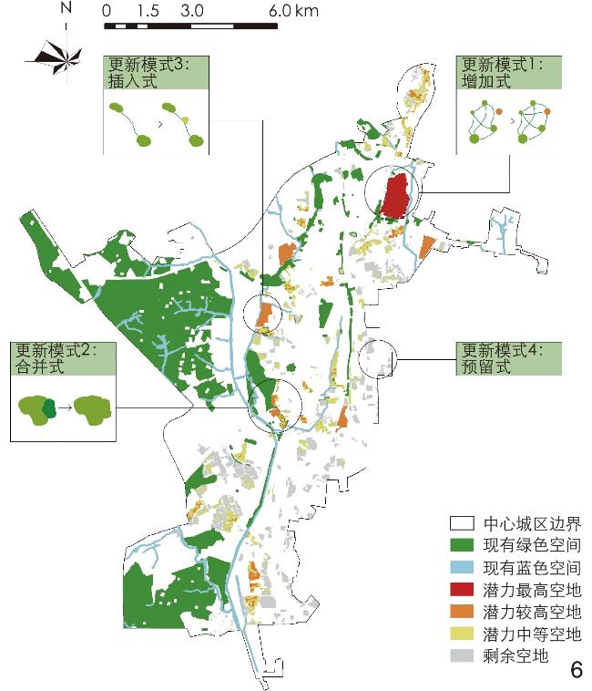
[Conclusion] For each potential level, this research proposes four renewal modes of increasing, merging, inserting and reserving for vacant lands to be renewed into GI. The research believes that it is possible to strengthen the function and optimize the pattern of GI network in the central urban area of Hegang by adding network centers, generating new connecting corridors, widening the original connecting corridors, or building small sites. For urban vacant lands with each potential level, the research proposes to base corresponding potential evaluation on resource endowment and maximize their green advantages; assist ecological restoration and achieve moderate and comprehensive development; meet the needs of residents and adapt to local conditions; prioritize ecological restoration and ensure a flexible and resilient planning strategy. The research quantifies the functional and structural levels of each vacant land in the central urban area of Hegang, identifies the styles of such vacant lands, and proposes suitable improvement mode to improve the GI network. Based on the location and prominent functional and structural characteristics of each vacant land, corresponding strategies are proposed, aiming to provide a basis for urban vacant land renewal.
LU Ming , JIN Meicen , ZHANG Yan . Evaluation of the Potential for Renewing Urban Vacant Land into Green Infrastructure[J]. Landscape Architecture, 2024 , 31(3) : 81 -88 . DOI: 10.3724/j.fjyl.202307070304
表1 数据来源及精度Tab. 1 Data source and accuracy |
| 数据类型 | 数据来源 | 数据格式(精度) |
|---|---|---|
| 土地利用数据 | 欧洲航天局(viewer.esa-worldcover.org/worldcover) | 栅格(10 m) |
| 高程数据 | 地理空间数据云(www.gscloud.cn/home) | 栅格(30 m) |
| 年降水栅格数据 | 国家地球系统科学数据中心(gre.geodata.cn) | 栅格(1 km) |
| 土壤数据 | 寒旱区科学大数据中心(bdc.casnw.net) | 栅格(1 km) |
| 植被覆盖数据 | 国家科技资源共享服务平台(www.nesdc.org.cn) | 栅格(30 m) |
| 兴趣点(point of interest, POI)数据 | 高德地图API | 矢量 |
| 道路矢量数据 | OpenStreetMap地图(www.openstreetmap.org) | 矢量 |
| 水系矢量数据 | OpenStreetMap地图(www.openstreetmap.org) | 矢量 |
| 城市空地数据 | 黑龙江省城市规划勘测设计研究院 | 矢量 |
| 第三次全国国土调查数据 | 黑龙江省城市规划勘测设计研究院 | 矢量 |
| 评估指标 | 计算式 | 参数含义 |
|---|---|---|
| 空气净化 | ${S}_{i}({ {\text{SO} } }_{2},{ {\text{NO} } }_{x},{ {\text{PM} } }_{10})={A}_{i}\times {P}_{i}$ | ${S}_{i}({ {\text{SO} } }_{2},{ {\text{NO} } }_{x},{ {\text{PM} } }_{10})$表示景观类型$ i $对空气污染物的截留吸收量;$ {A}_{i} $表示景观类型$ i $的面积;$ {P}_{i} $表示单位面积景观类型$ i $对空气污染物的截留吸收量[44-47] |
| 水体净化 | $ {P}_{i}=\dfrac{{\displaystyle\sum }_{i=1}^{n}{(S}_{i}\times {K}_{i})}{\displaystyle\sum\nolimits_{i=1}^{n}{S}_{i}} $ | $ {P}_{i} $表示最终空地的加权平均分值;$n$表示空地要素个数;$ {S}_{i} $表示空地包含的第$ i $类缓冲区的面积;$ {K}_{i} $表示第$ i $类缓冲区的分值[48-49] |
| 土壤保持 | ${ {{A} } }_{r}=R\times K\times L\times S\times (1-C\times P)$ | ${ {{A} } }_{r}$表示研究区域土壤保持量;$ R $为降雨侵蚀力因子;$ K $为土壤可蚀性因子;$ L $为坡长因子;$ S $为坡度因子;$ C $为植被覆盖因子;$P $为水土保持措施因子[50] |
| 生物多样性 | $ {Q}_{xj}={H}_{j}[1-{D}_{xj}^{z}/({D}_{xj}^{z}+{k}^{z})] $ | $ {Q}_{xj} $表示景观类型$ j $中栅格$ x $的生境质量;$ {H}_{j} $为第$ j $类景观的生境适宜度;$ {D}_{xj} $为第$ j $类景观中栅格$ x $所受胁迫程度;$ k $为半饱和常数,默认值为0.5;$ z $为归一化参数,默认值为2.5[51-52] |
| 植被覆盖度 | $ {\text{F}\text{V}\text{C}}_{i}=\dfrac{\text{N}\text{D}\text{V}\text{I}-{\text{N}\text{D}\text{V}\text{I}}_{\text{soil}}}{{\text{N}\text{D}\text{V}\text{I}}_{\text {veg}}-{\text{N}\text{D}\text{V}\text{I}}_{\text{soil}}} $ | $ {\text{F}\text{V}\text{C}}_{i} $为植被覆盖度;${\text{NDVI}}$为归一化植被指数;$ {\text{N}\text{D}\text{V}\text{I}}_{\text{soil}} $表示区域无植被或缺少植被覆盖的值;$ {\text{N}\text{D}\text{V}\text{I}}_{\text {veg}} $表示完全由植被覆盖的值[53] |
| 景观美学 | $ {\text{E}\text{S}\text{V}}_{i}={\displaystyle\sum }_{i=1}^{n}({\text{V}\text{C}}_{i}\times {A}_{i}) $ | $ {\text{E}\text{S}\text{V}}_{i} $表示景观美学价值;$n$表示地类要素个数;$ {\text{V}\text{C}}_{i} $表示第$ i $类地类单位面积ESs价值,元/hm2;$ {A}_{i} $表示第$ i $类地类的面积,hm2 [54-55] |
| 游憩潜力 | ${L}_{i}=\dfrac{-{\displaystyle\sum }_{K=1}^{K}{P}_{K,i}{\ln}({P}_{K,i})}{ {\ln}(K,i)}$ | $ {L}_{i} $表示土地利用混合度;${P}_{K,i}$表示第$ K $种POI在第$ i $个空地缓冲区中的数量占比;$ K $表示空地缓冲区$ i $的POI种类数量[42] |
| 游憩可达性 | ArcGIS近邻分析 |
表4 功能方面评估指标体系及权重Tab. 4 Evaluation indicator system and weights at the functional level |
| 目标层 | 准则层 | 权重 | 指标层 | 权重 |
|---|---|---|---|---|
| ESs供给 | 调节服务 | 0.3276 | 空气净化 | 0.1638 |
| 水体净化 | 0.1638 | |||
| 支持服务 | 0.2599 | 土壤保持 | 0.0545 | |
| 生物多样性 | 0.1429 | |||
| 植被覆盖度 | 0.0625 | |||
| 文化服务 | 0.4125 | 景观美学 | 0.0825 | |
| 游憩潜力 | 0.1650 | |||
| 游憩可达性 | 0.1650 |
表5 不同潜力等级的城市空地面积及其比例Tab. 5 Areas and proportions of urban vacant lands under different potential levels |
| 潜力等级 | 面积/hm2 | 所占比例/% | 主要所处区位 |
|---|---|---|---|
| 最高 | 105.39 | 7.87 | 向阳区与东山区交界处 |
| 较高 | 191.88 | 14.32 | 工农区、东山区、南山区 |
| 中等 | 370.35 | 27.64 | 六区均有分布 |
| 较低 | 487.80 | 36.41 | 六区均有分布 |
| 最低 | 184.50 | 13.76 | 南山区、兴安区 |
图6 鹤岗市中心城区城市空地更新模式示意Fig. 6 Schematic diagram of the renewal modes of urban vacant lands in the central urban area of Hegang |
表6 鹤岗市中心城区城市空地GI规划利用途径Tab. 6 GI planning and utilization of urban vacant lands in the central urban area of Hegang |
| 潜力等级 | 空地更新模式 | 规划利用途径 |
|---|---|---|
| 最高 | 增加式 | 生态保育:该等级空地生态本底好,景观连通性高,建议针对该类型的空地通过地质勘测选择改造方式。若地质为沉陷积水类型的区域,则易于形成天然湿地生态系统,根据积水深度及景观条件规划可更新为观赏型、环保型、综合型湿地公园;地质为淹没类型的区域可复垦为水田,发展为产学研实验基地或都市农业等产业;地质情况良好的区域可以结合城市绿地系统规划更新为城市公园、儿童公园等开敞空间 |
| 较高 | 合并式或插入式 | |
| 中等 | 插入式 | 生态修复:该等级空地在功能或结构某一方面存在优势,可以就近与高等级空地一同进行转化,也可作为GI网络的灵活补充,建议进行生态化更新,更新为社区绿地、口袋公园、街头绿地等社区级公共绿地 |
| 较低 | 预留式 | 生态恢复:该等级空地生态本底差,斑块面积小,ESs水平低,建议不对该类型空地进行人为干预,通过自然过程进行生态恢复;或优先考虑经济效益,进行转型发展;也可作为城市发展备用地或白地以便后期规划用地调整 |
| 最低 |
| [1] |
RICHARD N. Book Review: Shrinking Cities: Volume 1: International Research[J]. Urban Studies, 2008, 45 5-6: 1301-1303.
|
| [2] |
LI W F, ZHOU W Q, BAI Y, et al. The Smart Growth of Chinese Cities: Opportunities Offered by Vacant Land[J]. Land Degradation and Development, 2018, 29 (10): 3512-3520.
|
| [3] |
宋小青, 麻战洪, 赵国松, 等. 城市空地: 城市化热潮的冷思考[J]. 地理学报, 2018, 73 (6): 1033-1048.
SONG X Q, MA Z H, ZHAO G S, et al. Urban Vacant Land: Rethinking the Mushrooming Urbanization[J]. Acta Geographica Sinica, 2018, 73 (6): 1033-1048.
|
| [4] |
衣霄翔, 张郝萍, 夏雷. 国际收缩城市应对空置问题的临时使用策略及启示[J]. 城市规划学刊, 2022 (2): 111-118.
YI X X, ZHANG H P, XIA L. Tackling the Vacancy Problem in International Shrinking Cities: Temporary Use Strategy and Its Implications[J]. Urban Planning Forum, 2022 (2): 111-118.
|
| [5] |
贝内迪克特, 麦克马洪. 绿色基础设施: 连接景观与社区[M].黄丽玲, 朱强, 杜秀文, 等, 译. 北京: 中国建筑工业出版社, 2010.
BENEDICT M A, MCMAHON E T. Green Infrastructure: Connecting Landscape and Community[M]. HUANG L L, ZHU Q, DU X W, et al, translated. Beijing: China Architecture & Building Press, 2010.
|
| [6] |
毛齐正, 黄甘霖, 邬建国. 城市生态系统服务研究综述[J]. 应用生态学报, 2015, 26 (4): 1023-1033.
MAO Q Z, HUANG G L, WU J G. Urban Ecosystem Services: A Review[J]. Chinese Journal of Applied Ecology, 2015, 26 (4): 1023-1033.
|
| [7] |
LAFORTEZZA R, DAVIES C, SANESI G, et al. Green Infrastructure as a Tool to Support Spatial Planning in European Urban Regions[J]. iForest: Biogeosciences & Forestry, 2013, 6 (3): 102-108.
|
| [8] |
裴丹. 绿色基础设施构建方法研究述评[J]. 城市规划, 2012, 36 (5): 84-90.
PEI D. Review of Green Infrastructure Planning Methods[J]. City Planning Review, 2012, 36 (5): 84-90.
|
| [9] |
WANG J X, BANZHAF E, et al. Towards a Better Understanding of Green Infrastructure: A Critical Review[J]. Ecological Indicators: Integrating, Monitoring, Assessment and Management, 2018, 85: 758-772.
|
| [10] |
衣霄翔, 赵天宇, 吴彦锋, 等. “危机”抑或“契机”?: 应对收缩城市空置问题的国际经验研究[J]. 城市规划学刊, 2020 (2): 95-101.
YI X X, ZHAO T Y, WU Y F, et al. “Crisis” or “Opportunity”?: International Experiences in Dealing with Vacancy in Shrinking Cities[J]. Urban Planning Forum, 2020 (2): 95-101.
|
| [11] |
冯姗姗, 常江. 矿业废弃地: 完善绿色基础设施的契机[J]. 中国园林, 2017, 33 (5): 24-28.
FENG S S, CAHNG J. Abandoned Mine Land Ecological Restoration: An Opportunity to Improve Urban Green Infrastructure[J]. Chinese Landscape Architecture, 2017, 33 (5): 24-28.
|
| [12] |
胡庭浩, 常江, 思博. 德国绿色基础设施规划的背景、架构与实践[J]. 国际城市规划, 2021, 36 (1): 109-119.
HU T H, CHANG J, SYRBE R U. Green Infrastructure Planning in Germany: The Background, Spatial Framework and Implementations[J]. Urban Planning International, 2021, 36 (1): 109-119.
|
| [13] |
FRAZIER A E, BAGCHI-SEN S. Developing Open Space Networks in Shrinking Cities[J]. Applied Geography, 2015, 59: 1-9.
|
| [14] |
洪龙. 城市闲置用地生产性更新方法研究[D]. 天津: 天津大学, 2019.
HONG L. Research on Productive Renewal Method of Urban Vacant Land: Taking Nankai District, Tianjin as an Example[D]. Tianjin: Tianjin University, 2019.
|
| [15] |
KAMVASINOU K. The Public Value of Vacant Urban Land[J]. Proceedings of the Institution of Civil Engineers, 2011, 164 (3): 157-166.
|
| [16] |
MEEROW S, NEWELL J P. Spatial Planning for Multifunctional Green Infrastructure: Growing Resilience in Detroit[J]. Landscape & Urban Planning, 2017, 159 (3): 62-75.
|
| [17] |
HERBST H, HERBST V. The Development of an Evaluation Method Using a Geographic Information System to Determine the Importance of Wasteland Sites as Urban Wildlife Areas[J]. Landscape & Urban Planning, 2006, 77 1-2: 178-195.
|
| [18] |
宫聪, 吴祥艳, 胡长涓. 城市空地转变为绿色基础设施的系统性规划方法研究: 以美国里士满为例[J]. 中国园林, 2017, 33 (5): 74-79.
GONG C, WU X Y, HU C J. The Systematic Planning Method of Transforming Urban Vacant Land to Green Infrastructure: A Case Study of Richmond in USA[J]. Chinese Landscape Architecture, 2017, 33 (5): 74-79.
|
| [19] |
魏新星, 陈一欣, 黄静, 等. 城市低效用地更新为绿色基础设施优先度评价[J]. 生态学报, 2022, 42 (16): 6565-6578.
WEI X X, CHEN Y X, HUANG J, et al. Priority Evaluation of Urban Inefficient Lang Renewal to Green Infrastructure[J]. Acta Ecologica Sinica, 2022, 42 (16): 6565-6578.
|
| [20] |
刘芳. 生态系统服务需求视角下的城市闲置空地转变为GI的优先级评价研究[D]. 武汉: 华中农业大学, 2018.
LIU F. Research on the Priority of Urban Vacant Land Conversion to GI from the Perspective of Ecosystem Service Demand[M]. Wuhan: Huazhong Agriculture University, 2018.
|
| [21] |
马爽, 龙瀛. 基于绿色基础设施的中国收缩城市正确规模模型[J]. 西部人居环境学刊, 2018, 33 (3): 1-8.
MA S, LONG Y. The Right-Sizing Model in Chinese Shrinking Cities Based on Green Infrastructure[J]. Journal of Human Settlements in West China, 2018, 33 (3): 1-8.
|
| [22] |
高舒琦, 龙瀛. 东北地区收缩城市的识别分析及规划应对[J]. 规划师, 2017, 33 (1): 26-32.
GAO S Q, LONG Y. Distinguishing and Planning Shrinking Cities in Northeast China[J]. Planners, 2017, 33 (1): 26-32.
|
| [23] |
孙平军, 王柯文. 中国东北三省城市收缩的识别及其类型划分[J]. 地理学报, 2021, 76 (6): 1366-1379.
SUN P J, WANG K W. Identification and Stage Division of Urban Shrinkage in the Three Provinces of Northeast China[J]. Acta Geographica Sinica, 2021, 76 (6): 1366-1379.
|
| [24] |
WANG Y C, SHEN J K, XIANG W N. Ecosystem Service of Green Infrastructure for Adaptation to Urban Growth: Function and Configuration[J]. Ecosystem Health and Sustainability, 2018, 4 (5): 132-143.
|
| [25] |
GURRUTXAGA M, LOZANO P J, BARRIO G B. GIS-Based Approach for Incorporating the Connectivity of Ecological Networks into Regional Planning[J]. Journal for Nature Conservation, 2010, 18 (4): 318-326.
|
| [26] |
王云才, 申佳可, 彭震伟, 等. 适应城市增长的绿色基础设施生态系统服务优化[J]. 中国园林, 2018, 34 (10): 45-49.
WANG Y C, SHEN J K, PENG Z W, et al. The Optimization of Green Infrastructure Ecosystem Services Adapted to Urban Growth[J]. Chinese Landscape Architecture, 2018, 34 (10): 45-49.
|
| [27] |
COLDING J. “Ecological Land-Use Complementation” for Building Resilience in Urban Ecosystems[J]. Landscape & Urban Planning, 2007, 81 1-2: 46-55.
|
| [28] |
冯姗姗, 常江, 侯伟. GI引导下的采煤塌陷地生态恢复优先级评价[J]. 生态学报, 2016, 36 (9): 2724-2731.
FENG S S, CHANG J, HOU W. A Framework for Setting Restoration Priorities for Coal Subsidence Areas Based on Green Infrastructure (GI)[J]. Acta Ecologica Sinica, 2016, 36 (9): 2724-2731.
|
| [29] |
廖启鹏, 许红梅, 刘欣冉. 面向绿色基础设施体系优化的矿业废弃地再生研究: 以大冶为例[J]. 地质科技通报, 2021, 40 (4): 214-223.
LIAO Q P, XU H M, LIU X R. Regeneration of Mining Wasteland in View of Optimization of Urban Green Infrastructure System: A Case Study of Daye[J]. Bulletin of Geological Science and Technology, 2021, 40 (4): 214-223.
|
| [30] |
毛齐正, 罗上华, 马克明, 等. 城市绿地生态评价研究进展[J]. 生态学报, 2012, 32 (17): 5589-5600.
MAO Q Z, LUO S H, MA K M, et al. Research Advances in Ecological Assessment of Urban Greenspace[J]. Acta Ecologica Sinica, 2012, 32 (17): 5589-5600.
|
| [31] |
冯姗姗, 胡曾庆, 李玲, 等. 全生命周期视角下的闲置地转型绿地: 进展及思考[J]. 现代城市研究, 2021 (6): 93-101.
FENG S S, HU Z Q, LI L, et al. Vacant Land Greening from Perspective of the Whole Life Cycle: Review and Thought[J]. Modern Urban Research, 2021 (6): 93-101.
|
| [32] |
张纪朋. 煤炭资源型收缩城市空置土地绿色基础设施规划的潜力评估[D]. 哈尔滨: 哈尔滨工业大学, 2021.
ZHANG J P. Potential Evaluation of Green Infrastructure Planning of Vacant Land in Coal Resource-Based Shrinking Cities[M]. Harbin: Harbin Institute of Technology, 2021.
|
| [33] |
姜云, 魏志贺, 刘方宁, 等. 鹤岗市煤矿区废弃地再利用规划研究[J]. 低温建筑技术, 2018, 40 (11): 36-39.
JIANG Y, WEI Z H, LIU F N, et al. Reuse Planning of Wasteland in Hegang Coal Mining Areas[J]. Low Temperature Architecture Technology, 2018, 40 (11): 36-39.
|
| [34] |
邢忠, 汤西子, 周茜, 等. 城市边缘区绿色基础设施网络规划研究: 公益性产出保障导向[J]. 城市规划, 2020, 44 (12): 57-69.
XING Z, TANG X Z, ZHOU Q, et al. Green Infrastructure Network Planning in Urban Fringe: From the Perspective of Ensuring Public Goods Output[J]. City Planning Review, 2020, 44 (12): 57-69.
|
| [35] |
金华. 基于生态系统健康评价的城市矿业废弃地生态修复规划研究[D]. 哈尔滨: 哈尔滨工业大学, 2020.
JIN H. Ecological Restoration Planning of Urban Mining Wasteland Based on Ecosystem Health Assessment[D]. Harbin: Harbin Institute of Technology, 2020.
|
| [36] |
王云才, 申佳可, 象伟宁. 基于生态系统服务的景观空间绩效评价体系[J]. 风景园林, 2017, 24 (1): 35-44.
WANG Y C, SHEN J K, XIANG W N. The Framework of Landscape Space Performance Evaluation with the Orientation of Eco-system Service[J]. Landscape Architecture, 2017, 24 (1): 35-44.
|
| [37] |
张远景, 刘嘉博, 朱逊, 等. 国土空间生态修复视角下采煤沉陷区生态修复路径: 以鹤岗市中心城区为例[J]. 规划师, 2022, 38 (2): 95-101.
ZHANG Y J, LIU J B, ZHU X, et al. Ecological Restoration of Coal Mining Subsidence Area in Territorial Space Governance: Hegang Case[J]. Planners, 2022, 38 (2): 95-101.
|
| [38] |
王婧. 基于需求层次的北京市中心城区绿色空间生态系统服务功能评价、分析及优化策略研究[D]. 北京: 北京林业大学, 2020.
WANG J. Research on Green Space Ecosystem Service Evaluation, Analysis and Improvement Strategies in Beijing Central Districts Based on Demand Hierarchy[D]. Beijing: Beijing Forestry University, 2020.
|
| [39] |
史青松, 李刚, 赵建伟. 鹤岗市生态环境脆弱性演变分析[J]. 测绘与空间地理信息, 2020, 43 (3): 181-184.
SHI Q S, LI G, ZHAO J W. Analysis on Evolution of Eco-environment Vulnerability in Hegang City[J]. Geomatics & Spatial Information Technology, 2020, 43 (3): 181-184.
|
| [40] |
胡曾庆. 社会-生态功能需求下低效工业用地转型绿地多尺度潜力评价研究[D]. 徐州: 中国矿业大学, 2022.
HU Z Q. Research on Multi-scale Potential Evaluation of Inefficient Industrial Land Greening Under Social-Ecological Function Demand[D]. Xuzhou: China University of Mining and Technology, 2022.
|
| [41] |
RUPPRECHT C D D. Informal Urban Green Space: Residents’ Perception, Use, and Management Preferences Across Four Major Japanese Shrinking Cities[J]. Land, 2017, 6 (3): 59.
|
| [42] |
付迎春, 郭碧云, 王敏, 等. 社会—生态系统适应性治理视角下绿地空间恢复力的演化: 广州旧城区更新案例[J]. 自然资源学报, 2022, 37 (8): 2118-2136.
FU Y C, GUO B Y, WANG M, et al. Spatial Resilience Evolution of Green Space from the Perspective of Social-Ecological System Adaptive Governance: A Case Study for Urban Renewal in Guangzhou, China[J]. Journal of Natural Resources, 2022, 37 (8): 2118-2136.
|
| [43] |
陆明, 曲艺. 基于生态系统服务功能的区域生态网络构建: 以哈尔滨为例[J]. 中国园林, 2017, 33 (10): 103-107.
LU M, QU Y. Regional Ecological Network Construction Based on Ecosystem Service: A Case Study of Harbin[J]. Chinese Landscape Architecture, 2017, 33 (10): 103-107.
|
| [44] |
吴晓, 周忠学. 城市绿色基础设施生态系统服务供给与需求的空间关系: 以西安市为例[J]. 生态学报, 2019, 39 (24): 9211-9221.
WU X, ZHOU Z X. Spatial Relationship Between Supply and Demand of Ecosystem Services Through Urban Green Infrastructure: Case of Xi’an City[J]. Acta Ecologica Sinica, 2019, 39 (24): 9211-9221.
|
| [45] |
杨婉清, 杨鹏, 孙晓, 等. 北京市景观格局演变及其对多种生态系统服务的影响[J]. 生态学报, 2022, 42 (16): 6487-6498.
YANG W Q, YANG P, SUN X, et al. Changes of Landscape Pattern and Its Impacts on Multiple Ecosystem Services in Beijing[J]. Acta Ecologica Sinica, 2022, 42 (16): 6487-6498.
|
| [46] |
LANDUYT D, BROEKX S, ENGELEN G, et al. The Importance of Uncertainties in Scenario Analyses: A Study on Future Ecosystem Service Delivery in Flanders[J]. Science of the Total Environment, 2016, 553: 504-518.
|
| [47] |
位贺杰, 杨一鸣, 吴群. 多雾霾城市绿地空气净化服务与景观格局的关系: 以河南省安阳市区为例[J]. 水土保持通报, 2021, 41 (4): 292-299.
WEI H J, YANG Y M, WU Q. Relationship Between Air Purification Service and Landscape Pattern of Urban Green Space in City with More Haze: Taking Anyang Urban Area of He’nan Province as an Example[J]. Bulletin of Soil and Water Conservation, 2021, 41 (4): 292-299.
|
| [48] |
刘倩, 刘永杰, 余辉, 等. 太湖流域土地利用与河流水质污染状况的相关性研究[J]. 环境工程, 2016, 34 (8): 11-17.
LIU Q, LIU Y J, YU H, et al. The Correlation Study of Land Use and Water Quality Pollution Condition in Taihu Lake Watershed[J]. Environmental Engineering, 2016, 34 (8): 11-17.
|
| [49] |
汪昱昆, 程锐辉, 曾鹏, 等. 上海地区河网水质空间分异及对河岸带土地利用的响应[J]. 生态与农村环境学报, 2019, 35 (7): 925-932.
WANG Y K, CHENG R H, ZENG P, et al. Spatial Differentiation of Water Quality in River Networks in Shanghai and Its Response to Land Use in Riparian Zones[J]. Journal of Ecology and Rural Environment, 2019, 35 (7): 925-932.
|
| [50] |
邵明, 李方正, 李雄. 基于多源数据的成渝城市群绿色空间生态系统服务功能供需评价[J]. 风景园林, 2021, 28 (1): 60-66.
SHAO M, LI F Z, LI X. Evaluation of Supply and Demand of Green Space Ecosystem Service Function in Chengdu-Chongqing Urban Agglomeration Based on Multi-Source Data[J]. Landscape Architecture, 2021, 28 (1): 60-66.
|
| [51] |
SYRBE R U, MICHEL E, WALZ U. Structural Indicators for the Assessment of Biodiversity and Their Connection to the Richness of Avifauna[J]. Ecological Indicators, 2013, 31 (8): 89-98.
|
| [52] |
贾艳艳, 于东明, 王明杰, 等. 泰安市景观格局和生境质量时空演变及其关联分析[J]. 西北林学院学报, 2022, 37 (2): 229-237.
JIA Y Y, YU D M, WANG M J, et al. Spatio-Temporal Evolution and Correlation Analysis of Landscape Pattern and Habitat Quality in Tai’an City[J]. Journal of Northwest Forestry University, 2022, 37 (2): 229-237.
|
| [53] |
苗正红, 刘志明, 王宗明, 等. 基于MODIS NDVI的吉林省植被覆盖度动态遥感监测[J]. 遥感技术与应用, 2010, 25 (3): 387-393.
MIAO Z H, LIU Z M, WANG Z M, et al. Dynamic Monitoring of Vegetation Fraction Change in Jilin Province Based on MODIS NDVI[J]. Remote Sensing Technology and Application, 2010, 25 (3): 387-393.
|
| [54] |
谢高地, 张彩霞, 张雷明, 等. 基于单位面积价值当量因子的生态系统服务价值化方法改进[J]. 自然资源学报, 2015, 30 (8): 1243-1254.
XIE G D, ZHANG C X, ZHANG L M, et al. Improvement of the Evaluation Method for Ecosystem Service Value Based on Per Unit Area[J]. Journal of Natural Resources, 2015, 30 (8): 1243-1254.
|
| [55] |
刘宇舒. 生态服务测度下黑龙江省村镇空间优化研究[D]. 哈尔滨: 哈尔滨工业大学, 2018.
LIU Y S. Space Optimization of Villages and Towns in Heilongjiang Under the Ecological Service Measure[D]. Harbin: Harbin Institute of Technology, 2018.
|
| [56] |
唐明凯. 生态转型视角下鹤岗市生态文明建设策略研究[D]. 哈尔滨: 哈尔滨工业大学, 2018.
TANG M K. Research on the Strategy of Ecological Civilization Construction in Hegang City from the Perspective of Ecological Transformation[D]. Harbin: Harbin Institute of Technology, 2020.
|
| [57] |
TAYLOR P D, FAHRIG L, MERRIAM H G. Connectivity Is a Vital Element of Landscape Structure[J]. Oikos, 1993, 68 (3): 571-573.
|
| [58] |
陈利顶, 傅伯杰. 景观连接度的生态学意义及其应用[J]. 生态学杂志, 1996 (4): 37-42.
CHEN L D, FU B J. The Ecological Significance and Application of Landscape Connectivity[J]. Chinese Journal of Ecology, 1996 (4): 37-42.
|
| [59] |
刘天颖. 城市绿色基础设施网络构建及优化设计研究[D]. 邯郸: 河北工程大学, 2020.
LIU T Y. Research on the Construction and Optimal Design of Urban Green Infrastructure Network: Take Handan City as an Example[D]. Handan: Hebei University of Engineering, 2020.
|
| [60] |
傅伯杰, 陈利顶, 马克明, 等. 景观生态学原理及应用(第2版)[M]. 北京: 科学出版社, 2011.
FU B J, CHEN L D, MA K M, et al. Principles and Applications of Landscape Ecology (Second Edition)[M]. Beijing: Science Press, 2011.
|
/
| 〈 |
|
〉 |