
Structural System and Construction Method of the Existing “City − Lake Landscape” of 14 Ancient Cities in Yellow River Floodplain
|
QIU Yuanxun is a Ph.D. candidate in the School of Landscape Architecture, Beijing Forestry University. His research focuses on landscape planning and design |
|
WANG Ruiqi, Ph.D., is a lecturer in the School of Architecture and Urban Planning, Beijing University of Civil Engineering and Architecture. Her research focuses on landscape planning and design |
|
LI Xiong, Ph.D., is a professor and doctoral supervisor in the School of Landscape Architecture, Beijing Forestry University, and director of editorial board of this journal. His research focuses on landscape planning and design |
Received date: 2023-06-05
Online published: 2025-12-15
Copyright
[Objective] The hydrological characteristics of the Yellow River, which is easy to deposit, break dykes and migrate, have created a unique City – Lake Landscape phenomenon of city surrounding by lake that is commonly seen in the Yellow River Floodplain. The morphological features of such City – Lake Landscape are more regular than and significantly different from those in other regions, with the latter featuring city adjacency to the lake, city separation from the lake, lake embedding in the city, etc., which is of systematic research value. Taking the City – Lake Landscape in the Yellow River Floodplain as the research object, this research discusses the historical experience of intervening in hydrological process, responding to the Yellow River flood disaster, and accordingly reshaping regional landscape by virtue of ancient lake-based water conservancy facilities.
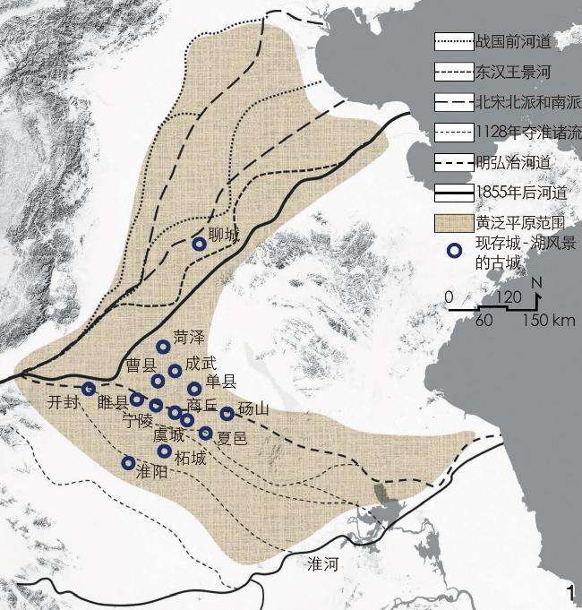
[Methods] Starting from the regional perspective of landscape architecture, this research combines local chronicle information mining with geospatial analysis with a focus on the City – Lake Landscape of 14 ancient cities in the Yellow River Floodplain, including Shangqiu, Xiayi, Yucheng, Suixian, Liaocheng, Caoxian, Chengwu, etc., and systematically explores the forming background, structure system and construction method of such City – Lake Landscape.
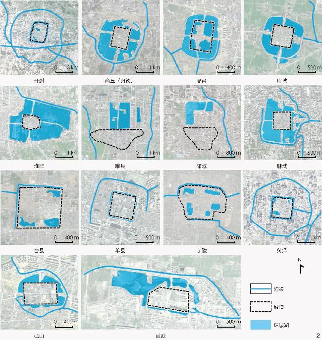
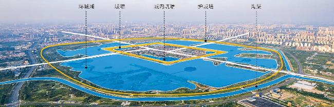
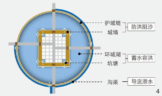
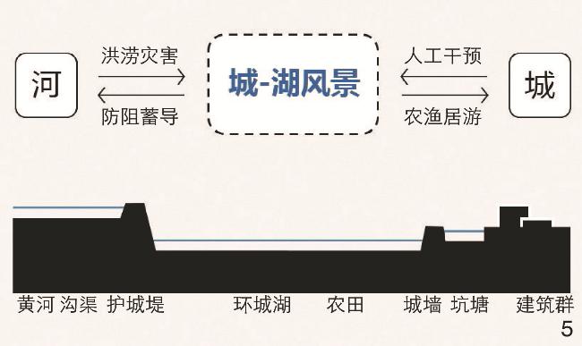
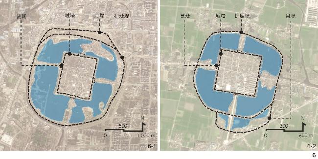
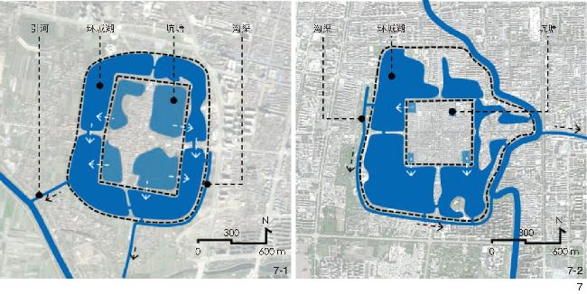
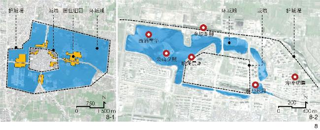
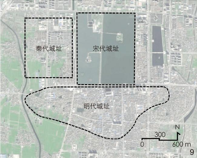
[Results] Firstly, the City – Lake Landscape phenomenon in the ancient cities in the Yellow River Floodplain is the result of the combined action of flood disaster and human intervention. The root cause of local flood disaster lies in the hydrological characteristics of the Yellow River, which is easy to deposit, break dykes and migrate, and the characteristics local flood disaster are highlighted in the following three aspects: 1) The high sediment concentration gradually elevates the terrain outside the city, giving birth to overground suspended river and basin terrain; 2) the suspended river frequently overflows and changes its course, causing damage and flooding to any ancient city flowing through it; 3) the basin terrain makes it difficult to eliminate waterlogging within the city, further exacerbating the difficulty of flood control. Secondly, the structural system of the City – Lake Landscape has three characteristics: 1) It is composed of five types of elements: city wall, city embankment, surrounding lake, pond and ditch; 2) the elements, based on the practical needs of flood control and the feudal etiquette system, jointly form a specific spatial structure of being round outside but square inside and the urban basin; 3) in addition, in terms of functional structure, the City – Lake Landscape not only has the hydraulic functions of flood control, sand blocking, water volume regulating and storing, and waterlogging diversion, but also has other functions such as agricultural and fishery production, and tourism, which can effectively alleviate the Yellow River flood disaster and support the sustainable development of the city. Thirdly, there are five construction methods for the City – Lake Landscape. 1) Follow the principle of being close to water with high altitude in city siting, which can not only avoid floods but also facilitate water intake. 2) Build city walls and embankments in line with water trend. The construction of city wall mainly adopts brick and stone cladding to improve flood resistance, reserves lateral door opening to avoid floods, blocks the city gate directly towards the flow direction of floods to prevent crevasse, and sets up water gate culverts to quickly drain floods. The construction methods of city embankment include building embankments in line with water trend to disperse flood impact, connecting city embankments into a ring to provide comprehensive flood control, building double embankments at areas vulnerable to erosion to improve local flood resistance, and further strengthening the earth embankment by planting trees. 3) Integrate the excavation of surrounding lakes and city ponds with the construction of city walls and embankments, dredge surrounding lakes and ponds for flood storage and drainage, and use the resulting earthwork to construct city walls and embankments for flood control and avoidance, assisted by culverts and ditches to timely divert and discharge waterlogging and thus reduce storage pressure. 4) Local residents prefer buildings near water, forming a landscape layout mode of front street and back lake. Besides, local landscape planning also relies heavily on water conservancy elements such as surrounding lakes, ponds, city embankments and earth terraces. Typical landscape patterns include: Lake – embankment – bridge – boat – lotus and willow, river – embankment – willow – fog and rain, lake – earth terrace – sunset – fog and rain, etc. 5) If it is difficult for the City – Lake Landscape in a city to withstand the extreme Yellow River flood disaster, the city will be relocated to a new highland outside the embankment, and the original city site will be submerged by floods, ultimately forming a landscape pattern featuring the interdependency between the old underwater city and the new city.
[Conclusion] This research summarizes the structural system characteristics and construction method of the ancient City – Lake Landscape in the Yellow River Floodplain through the mining of local chronicles and the analysis method of geospatial information technology. The research points out that City – Lake Landscape is a regional adaptive landscape formed by the joint action of the Yellow River flood disaster and manual intervention. Only by fully understanding the structural system and construction method of the City – Lake Landscape can the contemporary value thereof be reoriented and such landscape be better protected and developed.
QIU Yuanxun , WANG Ruiqi , LI Xiong . Structural System and Construction Method of the Existing “City − Lake Landscape” of 14 Ancient Cities in Yellow River Floodplain[J]. Landscape Architecture, 2024 , 31(4) : 118 -124 . DOI: 10.3724/j.fjyl.202306050259
表1 黄泛平原古城八景统计Tab. 1 Statistics of eight scenic spots of ancient cities in the Yellow River Floodplain |
| 八景名称 | 景源条件 | |||
|---|---|---|---|---|
| 环城湖、坑塘 | 护城堤、城墙 | 黄河、运河 | 岗台遗址 | |
| 汴京八景 | 金池夜雨、州桥明月 | 隋堤烟柳 | 汴水秋声 | 繁台春色 |
| 夏邑八景 | 龙湖秋韵、拱桥卧波 | — | 运河夕照 | — |
| 淮阳八景 | 蔡池秋月、柳湖渔唱 | — | — | 望台烟雨 |
| 睢县八景 | 泮水澄波 | 汴柳堤色 | — | 襄台夕照 |
| 曹县八景 | 龙潭月色、玉带横桥 | 金堤烟柳 | — | — |
| 成武六景 | 映湖晨烟、西浦荷华 雁池秋月 | — | — | 寿峰朝曛 云山夕照 |
| 砀山八景 | 秋池邀月 | 春堤引风 | 星海洪涛 | 层台鼓韵 |
文中图表均由作者绘制和拍摄,其中
| [1] |
郑曦. 鉴湖、西湖、湘湖: 钱塘江下游地区三大著名湖泊的景观演变与城市化发展启示[J]. 中国园林, 2014, 30 (11): 69-73.
ZHENG X. Jian Lake, West Lake, Xiang Lake: Landscape Evolution of Three Famous Lakes and Local Urbanism in Downstream Area of Qiantang River[J]. Chinese Landscape Architecture, 2014, 30 (11): 69-73.
|
| [2] |
张雪葳, 王向荣. 陂塘水利对城市及地域景观格局的影响: 以杭州西湖为例[J]. 中国园林, 2018, 34 (6): 19-24.
ZHANG X W, WANG X R. The Influence of Pond Irrigation Works on Landscape Patterns of Cities and Regions: A Case Study of Hangzhou West Lake[J]. Chinese Landscape Architecture, 2018, 34 (6): 19-24.
|
| [3] |
马萌雨. 宁波甬江地区城市山水系统营建思想研究[D]. 北京: 北京林业大学, 2019.
MA M Y. Study on the Plan and Construction Methodology for Urban Mountain-Water System in Ningbo Yongjiang Area[D]. Beijing: Beijing Forestry University, 2019.
|
| [4] |
郭巍, 侯晓蕾. 双城、三山和河网: 福州山水形势与传统城市结构分析[J]. 风景园林, 2017, 24 (5): 94-100.
GUO W, HOU X L. Two Cities, Three Mountains and River Net: Analysis of Fuzhou’s Landscape Pattern and Traditional Urban Form[J]. Landscape Architecture, 2017, 24 (5): 94-100.
|
| [5] |
邱彩琳, 林箐. 潮州古城传统人居环境空间特征研究[J]. 现代城市研究, 2019 12: 7-16.
QIU C L, LIN Q. A Study on the Spatial Characteristics of Chaozhou Ancient City Based on Landscape Construction Tradition of Chinese Cities[J]. Modern Urban Research, 2019 12: 7-16.
|
| [6] |
莫林芳. 桂林主城区山水景观初探[D]. 北京: 北京林业大学, 2015.
MO L F. A Study on Hill-Water Landscape in Urban Area in Guilin[D]. Beijing: Beijing Forestry University, 2015.
|
| [7] |
毛华松. 西湖文化的演进历程及其历史意义: 《永乐大典·六模湖》中的西湖文献统计分析[J]. 中国园林, 2014, 30 (11): 117-120.
MAO H S. The Evolving Procedure and Historical Significance of the West Lake: A Statistic Analysis on Literatures About the West Lake in The Yongle Canon: Six Pattern Lake[J]. Chinese Landscape Architecture, 2014, 30 (11): 117-120.
|
| [8] |
王晞月. 中国古代陂塘系统及其与城市的关系研究[D]. 北京: 北京林业大学, 2019.
WANG X Y. The Impounding Lake System of China and Its Relationship with Ancient Cities[D]. Beijing: Beijing Forestry University, 2019.
|
| [9] |
张诗阳. 都城水系营造及其对区域景观的影响: 以汉魏洛阳为例[J]. 中国园林, 2020, 36 (9): 127-132.
ZHANG S Y. The Construction of Water System in Capital Region and Its Influence on Regional Landscape: A Case Study of Luoyang in Han and Wei Dynasties[J]. Chinese Landscape Architecture, 2020, 36 (9): 127-132.
|
| [10] |
史念海. 河山集(二集)[M]. 北京: 生活·读书·新知三联书店, 1981.
SHI N H. Collected Works on Rivers and Mountains (Episode 2)[M]. Beijing: SDX Joint Publishing Company, 1981.
|
| [11] |
吴宏岐, 张志迎. 黄泛平原古城镇水域景观历史地理成因初探[J]. 地域研究与开发, 2012 (1): 145-149.
WU H Q, ZHANG Z Y. A Preliminary Study on the Historical and Geographical Causes of the Water Landscape of Ancient Towns in the Yellow River Floodplain[J]. Areal Research and Development, 2012 (1): 145-149.
|
| [12] |
吴朋飞. 黄河影响下古城研究的几点认识[J]. 三门峡职业技术学院学报, 2012 (4): 6-9.
WU P F. Several Understandings on the Study of Ancient Cities Under the Influence of the Yellow River[J]. Journal of Sanmenxia Vocational and Technical College, 2012 (4): 6-9.
|
| [13] |
吴庆洲. 中国古城防洪研究[M]. 北京: 中国建筑工业出版社, 2009.
WU Q Z. Research on Flood Control in Ancient Chinese Cities[M]. Beijing: China Architecture & Building Press, 2009.
|
| [14] |
俞孔坚, 张蕾. 黄泛平原古城镇洪涝经验及其适应性景观[J]. 城市规划学刊, 2007 (1): 85-91.
YU K J, ZHANG L. The Flood and Waterlog Adaptive Landscapes in Ancient Chinese Cities in the Yellow River Basin[J]. Urban Planning Forum, 2007 (1): 85-91.
|
| [15] |
俞孔坚, 张蕾. 黄泛平原区适应性“水城”景观及其保护和建设途径[J]. 水利学报, 2008 (6): 688-696.
YU K J, ZHANG L. Adaptive “Water City” Landscape and Its Protection and Construction Approaches in the Yellow River Floodplain Area[J]. Journal of Hydraulic Engineering, 2008 (6): 688-696.
|
| [16] |
陈曦. 河南商丘地区古城洪涝适应性景观研究[D]. 北京: 北京大学, 200.
CHEN X. The Flood Adaptive Landscapes in Ancient Chinese Cities of Shangqiu Area[D]. Beijing: Peking University, 2008.
|
| [17] |
许继清. 黄泛平原“水域古城”的生成与演进[D]. 南京: 东南大学, 2009: 92.
XU J Q. The Formation and Evolution of the “Ancient Cities in Water Area” in the Yellow River Floodplain[D]. Nanjing: Southeast University, 2009: 92.
|
| [18] |
许继清, 曹坤梓. 黄泛平原“水域古城”类型与特色研究[C].//中国城市规划学会.转型与重构: 2011中国城市规划年会论文集. 南京: 东南大学出版社, 2011: 7958-7959.
XU J Q, CAO K Z. A Study on the Types and Characteristics of “Ancient Cities in Water Area” in the Yellow River Floodplain[C]//Urban Planning Society of China. Transformation and Reconstruction: Proceedings of the 2011 China Urban Planning Annual Conference. Nanjing: Southeast University Press, 2011: 7958-7959.
|
| [19] |
韩茂莉. 中国历史地理十五讲[M]. 北京: 北京大学出版社, 2017.
HAN M L. Fifteen Lectures on Chinese Historical Geography[M]. Beijing: Peking University Press, 2017.
|
| [20] |
曹县地方志编纂委员会. 曹县志[M]. 北京: 方志出版社, 2013.
Cao County Chronicles Compilation Committee. Chronicles of Cao County[M]. Beijing: Local Records Press, 2013.
|
| [21] |
睢县志编纂委员会. 睢县志[M]. 郑州: 中州古籍出版社, 1989.
Sui County Chronicles Compilation Committee. Chronicles of Sui County[M]. Zhengzhou: Zhongzhou Ancient Books Publishing House, 1989.
|
| [22] |
虞城县志编纂委员会. 虞城县志[M]. 上海: 上海三联书店, 1991.
Yucheng County Chronicles Compilation Committee. Chronicles of Yucheng County[M]. Shanghai: Shanghai Joint Publishing Corporation, 1991.
|
| [23] |
商丘地区地方志编纂委员会. 归德府志[M]. 郑州: 中州古籍出版社, 1994.
Shangqiu Chronicles Compilation Committee. Chronicles of Guide Prefecture[M]. Zhengzhou: Zhongzhou Ancient Books Publishing House, 1994.
|
| [24] |
夏邑县志编纂委员会. 夏邑县志[M]. 郑州: 河南人民出版社, 1989.
Xiayi County Chronicles Compilation Committee. hronicles of Xiayi County[M]. Zhengzhou: Henan People’s Publishing House, 1989.
|
| [25] |
柘城县志编纂委员会. 柘城县志[M]. 郑州: 中州古籍出版社, 1991.
Zhecheng County Chronicles Compilation Committee. Chronicles of Zhecheng County[M]. Zhengzhou: Zhongzhou Ancient Books Publishing House, 1991.
|
| [26] |
王枚. 续修睢州志[M]. 台北: 学生书局, 1968.
WANG M. Continuation of Chronicles of Suizhou[M]. Taipei: Student Bookstore, 1968.
|
| [27] |
睢县史志编纂委员会. 睢州志[M]. 郑州: 中州古籍出版社, 1989.
Sui County Historical Records Compilation Committee. Chronicles of Suizhou[M]. Zhengzhou: Zhongzhou Ancient Books Publishing House, 1989.
|
| [28] |
刘春迎. 考古开封[M]. 郑州: 河南大学出版社, 2006.
LIU C Y. Archaeological Kaifeng[M]. Zhengzhou: Henan University Press, 2006.
|
| [29] |
菏泽市牡丹区史志办. 新修菏泽县志[M]. 北京: 中国文史出版社, 2013.
Historical Records Office of Mudan District, Heze City. Newly Revised Chronicles of Heze County[M]. Beijing: China Literature and History Publishing House, 2013.
|
| [30] |
宁陵县地方志编纂委员会. 宁陵县志[M]. 郑州: 中州古籍出版社, 1989.
Ningling County Chronicles Compilation Committee. Chronicles of Ningling County[M]. Zhengzhou: Zhongzhou Ancient Books Publishing House, 1989.
|
| [31] |
聊城市地方史志编纂委员会. 聊城市志[M]. 济南: 齐鲁书社, 1999.
Liaocheng Chronicles Compilation Committee. Chronicles of Liaocheng[M]. Jinan: Qilu Bookstore, 1999.
|
/
| 〈 |
|
〉 |