
Space Construction of Meihua Fortress Coastal Defense Settlement in Fujian in Ming Dynasty Under the Influence of Water Environment
|
FU Yanran is an undergraduate student in the School of Architecture and Urban-Rural Planning, Fuzhou University. Her research focuses on traditional settlement |
|
LIN Zhisen, Ph.D., is a professor in the School of Architecture and Urban-Rural Planning, Fuzhou University, and director of Fujian Regional Architecture Research Center. His research focuses on research and creation of regional architecture |
|
LI Lingxiu is an undergraduate student in the School of Architecture and Urban-Rural Planning, Fuzhou University. Her research focuses on defensive architecture |
|
SHEN Yangfan is an undergraduate student in the School of Architecture and Urban-Rural Planning, Fuzhou University. Her research focuses on urban water environment |
Received date: 2023-05-14
Online published: 2025-12-15
Copyright
[Objective] As a kind of special historical and cultural landscape, coastal defense settlements in Ming Dynasty were often distributed along the coast. Considering the special geographical characteristics of the coast, in addition to meeting the basic functions of military defense, coastal defense settlements should also meet the water environment requirements for flood control and drainage, which may affect their siting and spatial layout. Minjiang River Estuary is the estuary of the capital of Fujian Province, which has important strategic significance in the coastal defense system of Fujian Province. Meihua Fortress is an important military defense post guarding the entrance of Minjiang River Estuary. This research may contribute to the protection and development of coastal settlements including Meihua Fortress, to the exploration of local cultural value. and also to the protection and research of regional settlements under the influence of water environment. It may also expand research perspectives on the protection and utilization of cultural landscape about the relationship between human and environment.
[Methods] Taking Meihua Fortress in Fujian in Ming Dynasty as an example, this research conducts a field investigation and integrates the science of human settlement environment with such disciplines as history, military science, hydraulics and geography. Moreover, the research conducts a quantitative analysis by using ArcGIS tools to analyze slope, slope aspects, reclassification and cost distance based on digital elevation model (DEM) data and using DepthMapX software to analyze street characteristic based on space syntax. Starting from the man-land relationship, the research explores the spatial construction characteristics of coastal defense settlements under the influence of water environment in the aspects of enemy resisting, flood control, moisture protection, drainage, and water intaking, so as to supplement and deepen the research on coastal defense settlements.
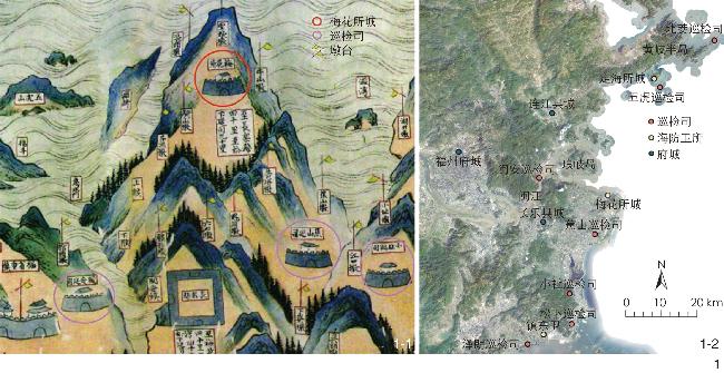
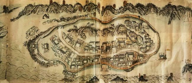
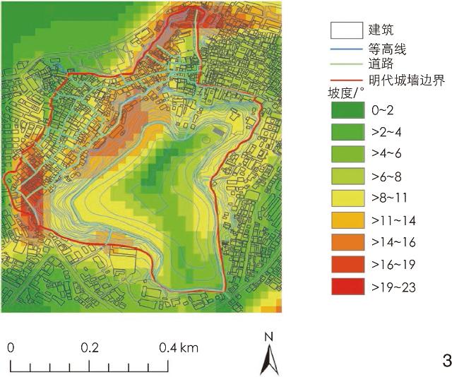
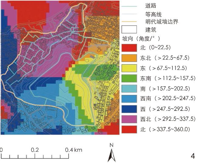
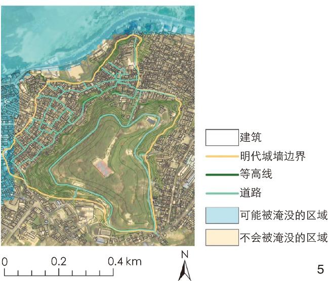
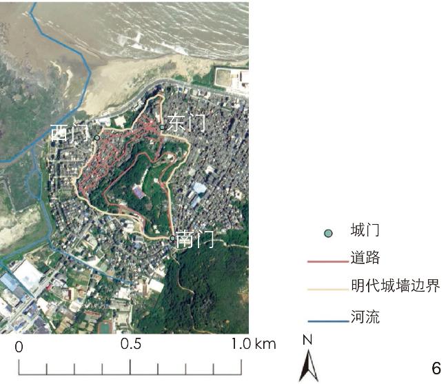
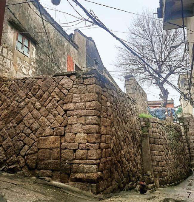
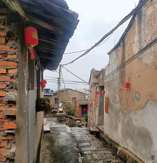
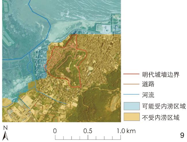
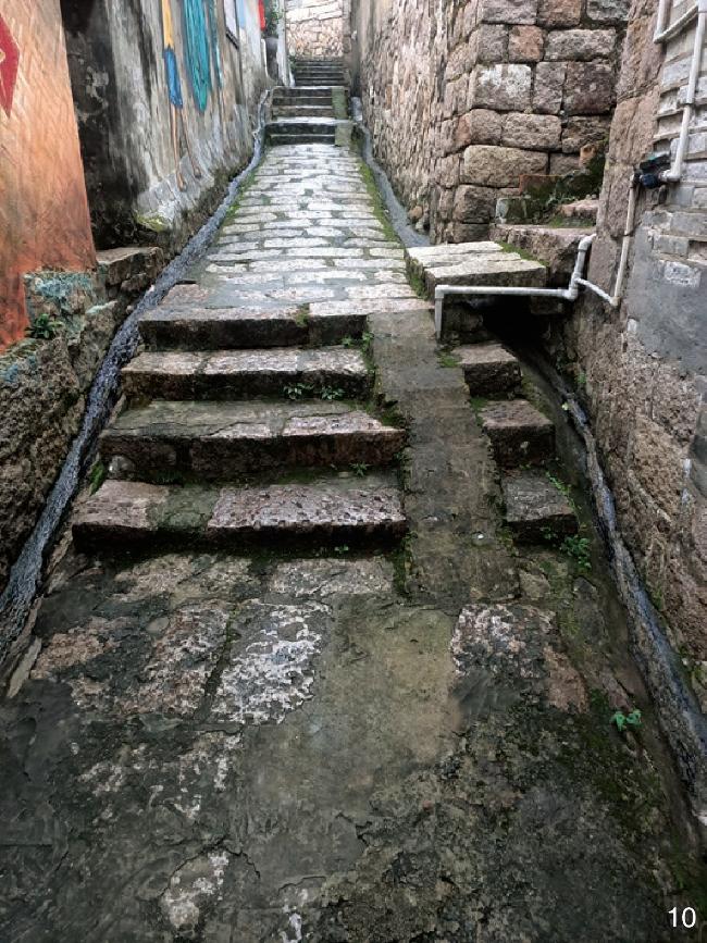
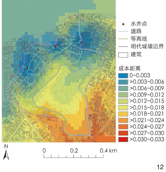
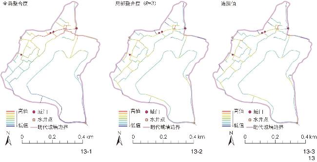
[Results] The results show that Meihua Fortress leans against mountain while facing water, which is sited in consideration of such factors as sea control, altitude control, risk control and accessibility conducive to military defense. Relying on the natural environment, Meihua Fortress was off the coast in Ming Dynasty to effectively monitor the northern sea area of the Minjiang River Estuary District and form a good observation post. Being mostly located above the highest tide level in history by then, Meihua Fortress can basically resist the invasion of tides without the consideration of embankments. Considering factors such as terrain and topography, Meihua Fortress was built on high ground in avoidance of low-lying stagnant areas. Meihua Fortress had no river inside, with only the Meihua River located 200 meters away from the southwest side of the city to reduce the impact of flooding and waterlogging. Meihua Fortress built multiple layers of defense, including the barbican entrance in the east gate as an important core site, the firm city walls constituting the peripheral defense system together with the trenches around, as well as relevant stone houses and stone retaining walls. Meihua Fortress strengthened resistance to enemies and the ability to resist flood and sea salt erosion in the construction of multiple building details. Thanks to the high terrain, the external flood around Meihua Fortress can be directly discharged into the downstream low-lying areas through the main ditches around Meihua Fortress. Meihua Fortress adopted streets and alleys for internal drainage. Specifically, it leveraged the elevation difference of terrain, slope and slope aspects of Mount Gui to divert rainwater from the southeast of the city to the low and flat areas in the northwest, and leveraged its own street ditches to dredge rainwater and strengthen drainage in order to reduce the pressure of rainstorm and flood on buildings and streets, and ensure the safety of villages, streets and buildings for drainage. Meanwhile, the buildings in Meihua Fortress also contributed to drainage by setting drain under the stone steps and on the walls and oblique roofs overhanging wall surface. Because of the distance away from the river, the water intaking resource was mainly from the wells in Meihua Fortress. The wells reasonably built inside the city could meet the production and living needs of the soldiers and civilians, while protecting them from being poisoned by enemy forces outside the city and ensuring water supply in case of siege to keep water safe. According to the results of the analysis of the cost distance from each designated location to water well points in Meihua Fortress in ArcGIS and the analysis of the global integration, regional integration (R=3) and connectivity value of Meihua Fortress, the research figured out that the distribution of wells affected the layout of streets. Using the methods mentioned above can achieve the effect of no waterlogging arising from heavy rain, and meet the needs of local residents to resist floods in the face of less manpower and single production and life mode in Ming Dynasty.
[Conclusion] Coastal defense settlements represented by Meihua Fortress in Ming Dynasty were sited on the basis of the influence of water environment, which contributed to the formation of a special spatial layout meeting local needs for defense and development. Such spatial layout is characterized by the combination of flood control and drainage with defense against enemies, which may provide reference for the protection and research of historical cultural landscape such as coastal defense settlements, and provide inspiration for the construction of modern resilient cities.
FU Yanran , LIN Zhisen , LI Lingxiu , SHEN Yangfan . Space Construction of Meihua Fortress Coastal Defense Settlement in Fujian in Ming Dynasty Under the Influence of Water Environment[J]. Landscape Architecture, 2024 , 31(4) : 133 -139 . DOI: 10.3724/j.fjyl.202305140230
| [1] |
邢浩. 明福建地区海防军事聚落布局研究[D]. 天津: 天津大学, 2019.
XING H. Study on the Layout of the Military Settlements of Fujian Coastal Defense System in Ming Dynasty[D]. Tianjin: Tianjin University, 2019.
|
| [2] |
张晋. 水适应性景观认知与研究框架解析: 以北京市门头沟地区为例[J]. 景观设计学, 2020, 8 (1): 56-71.
ZHANG J. Cognition and Research Framework of Water Adaptive Landscapes with the Case Study on Mentougou District, Beijing[J]. Landscape Architecture Frontiers, 2020, 8 (1): 56-71.
|
| [3] |
XIA J, QIU B, LI Y Y. Water Resources Vulnerability and Adaptive Management in the Huang, Huai and Hai River Basins of China[J]. Water International, 2012, 37 (5): 523-536.
|
| [4] |
LI Z, HUANG S, WANG H, et al. Digital Analysis of the Water Layout Ecological Wisdom in Traditional Chinese Rural Settlements: A Case Study of Liukeng Village in Jiangxi Province[J]. Journal of Resources and Ecology, 2022, 13 (3): 371-381.
|
| [5] |
MCCORD P, WALDMAN K, BALDWIN E, et al. Assessing Multi-level Drivers of Adaptation to Climate Variability and Water Insecurity in Smallholder Irrigation Systems[J]. World Development, 2018: 296-308.
|
| [6] |
OKPARA U T, STRINGER L C, DOUGILL A J. Integrating Climate Adaptation, Water Governance and Conflict Management Policies in Lake Riparian Zones: Insights from African Drylands[J]. Environmental Science & Policy, 2018, 79.
|
| [7] |
李晓溪, 赵守航, 李运远. 水适应性视角下泉水聚落生态智慧研究: 以泥淤泉村为例[J]. 小城镇建设, 2021, 39 (7): 84-93.
LI X X, ZHAO S H, LI Y Y. Ecological Wisdom of Spring Settlement from the Perspective of Water Adaptability: Taking Niyuquan Village as an Example[J]. Development of Small Cities & Towns, 2021, 39 (7): 84-93.
|
| [8] |
潘莹, 吴奇, 施瑛. 广东西江流域乡土聚落的水适应性景观营造模式研究[J]. 新建筑, 2021 (5): 11-16.
PAN Y, WU Q, SHI Y. Research on the Water Adaptive Landscape Construction Model of Settlement Environment in Xijiang River Basin[J]. New Architecture, 2021 (5): 11-16.
|
| [9] |
程严. 徽州传统村落水系适应性空间营造研究: 以黟县地区为例[D]. 合肥: 安徽农业大学, 2023.
CHENG Y. Study on the Adaptive Space Construction of Water System in Huizhou Traditional Villages: Taking Yixian County as an Example[D]. Hefei: Anhui Agricultural University, 2023.
|
| [10] |
王科, 冯君明, 林箐. 黄河与运河影响下鲁南传统沿运市镇水适应性空间特征[J]. 风景园林, 2023, 30 (1): 69-77.
WANG K, FENG J M, LlN Q. Water Adaptive Spatial Characteristics of Traditional Towns Along the Grand Canal in Southern Shandong Under the Influence of the Grand Canal and the Yellow River[J]. Landscape Architecture, 2023, 30 (1): 69-77.
|
| [11] |
连冠一. 基于水适应性的黄泛平原黄河流域段村落空间形态研究[D]. 济南: 山东建筑大学, 2022.
LIAN G Y. Research on the Spatial Morpology of Villages in the Yellow River Basin in the Yellow River Plain Based on Water Adaptability[D]. Jinan: Shandong Jianzhu University, 2022.
|
| [12] |
林志森, 吴正鹏, 吴智鑫, 等. 海洋文化视角下的明代福建海防所城聚落形态研究[J]. 新建筑, 2019 (5): 118-122.
LIN Z S, WU Z P, WU Z X, et al. A Study on the Settlement Pattern of Fujian Coastal Defense Suocheng in Ming Dynasty in the Perspective of Oceanic Culture[J]. New Architecture, 2019 (5): 118-122.
|
| [13] |
杨祖福. 明代泉州海防卫所的聚落形态探究: 以崇武所城为例[D]. 福州: 福州大学, 2016.
YANG Z F. Research the Settlement Forms of the Quanzhou Coastal Defense Garrison in Ming Dynasty: Taking Chongwu Fortress as an Example[D]. Fuzhou: Fuzhou University, 2016.
|
| [14] |
张建. 中国古代海防型聚落营造经验初探: 以洋屿水师旗营为例[J]. 华中建筑, 2020, 38 (11): 137-141.
ZHANG J. A Preliminary Research on the Construction of the Coastal-Defensive Settlements in China: A Case Study of Yangyu Navy Camp[J]. Huazhong Architecture, 2020, 38 (11): 137-141.
|
| [15] |
林志森, 郑炜, 胡捷昭, 等. 论明代闽江口地区海防聚落的空间形态特征[J]. 福州大学学报(哲学社会科学版), 2017, 31 (4): 12-16.
LIN Z S, ZHEN W, HU J Z, et al. On the Spatial Morphological Characteristics of Coastal Defense Settlements in Minjiang River Estuary District in Ming Dynasty[J]. Journal of Fuzhou University (Philosophy and Social Sciences), 2017, 31 (4): 12-16.
|
| [16] |
孙靖国. 舆图指要: 中国科学院图书馆藏中国古地图叙录[M]. 北京: 中国地图出版社, 2012: 327-333.
SUN J G. Map Guide: A Narrative Record of Ancient Chinese Maps in the Library of Chinese Academy of Sciences[M]. Beijing: Sinomaps Press, 2012: 327-333.
|
| [17] |
吴蓓, 谭立峰, 张玉坤. 明代海防与长城军事聚落时空演变比较研究: 以南直隶海防与宣府镇长城为例[J]. 中国文化遗产, 2021 (1): 101-108.
WU B, TAN L F, ZHANG Y K. Comparative Study on the Temporal and Spatial Evolution of Ming Dynasty Coastal Defense and Great Wall Military Settlements: A Case Study of Coastal Defense in Southern Zhili and Xuanfu Town Great Wall[J]. China Cultural Heritage, 2021 (1): 101-108.
|
| [18] |
福州市长乐区梅花镇志编纂委员会. 梅花镇志[M]. 郑州: 中州古籍出版社, 2021.
Meihua Annals Compilation Committee of Changle District, Fuzhou. Meihua Annals[M]. Zhengzhou: Zhongzhou Ancient Books Press, 2021.
|
| [19] |
胡捷昭. 明代福建海防长乐梅花所城聚落形态研究[D]. 福州: 福州大学, 2017.
HU J Z. Research the Settlement Forms of the Fujian Coastal Defense Meihua Fortress in Ming Dynasty[D]. Fuzhou: Fuzhou University, 2017.
|
| [20] |
刘早, 段炼孺. 陕西旬邑古崖居聚落防御性特征研究[J]. 重庆建筑, 2023, 22 (2): 32-36.
LIU Z, DUAN L R. Study on Defensive Characteristics of Xunyi Ancient Cliff Settlements in Shaanxi[J]. Chongqing Architecture, 2023, 22 (2): 32-36.
|
| [21] |
杨为彬. 明代福建平海卫防御体系下莆禧所城聚落形态研究[D]. 福州: 福州大学, 2023.
YANG W B. Research on Settlement of Puxi Suocheng Under the System of Pinghai Wei Defense Area of Fujian in Ming Dynasty[D]. Fuzhou: Fuzhou University, 2023.
|
| [22] |
李驹. 长乐县志[M]. 福州: 福建人民出版社, 1993: 132.
LI J. Changle Annals[M]. Fuzhou: Fujian People’s Publishing House, 1993: 132.
|
| [23] |
顾祖禹. 读史方舆纪要[M]. 北京: 中华书局, 2005: 4393.
GU Z Y. Essentials of Geography for Reading History[M]. Beijing: Zhonghua Book Company, 2005: 4393.
|
| [24] |
太湖流域管理局水文局(信息中心). 中华人民共和国水文年鉴 2015 第7卷 第4、5册 水文测站考证资料[Z]. 潍坊: 山东水文印务有限公司, 2017.
Hydrology Bureau of Taihu Basin Authority (Information Center). China Hydrologic Year Book, 2015, Volume 7, Issues 4 and 5, Hydrologic Station Verification Data[Z]. Weifang: Shandong Hydrological Printing Co., Ltd., 2017.
|
| [25] |
河海大学设计研究院有限公司. 长乐市防潮防洪排涝规划[R]. 福州: 长乐市人民政府, 2015.
Hohai University Design Institute Co., Ltd. Flood Control and Drainage Plan in Changle[R]. Fuzhou: Changle Municipal People’s Government, 2015.
|
| [26] |
贺鼎, 郑淳之, 王子瑜. 北京长城堡寨聚落水环境适应性景观特征[J]. 风景园林, 2023, 30 (4): 115-122.
HE D, ZHENG C Z, WANG Z Y. Landscape Characteristics Adaptive to Water Environment of the Great Wall Fortress Settlements in Beijing[J]. Landscape Architecture, 2023, 30 (4): 115-122.
|
| [27] |
张兵华, 刘淑虎, 李建军, 等. 闽东地区庄寨建筑防御性营建智慧解析: 以永泰县庄寨为例[J]. 新建筑, 2019 (1): 120-125.
ZHANG B H, LIU S H, LI J J, et al. The Research on the Defensive Construction Wisdom of Zhuangzhai in Eastern Fujian: The Case of Yongtai Zhuangzhai[J]. New Architecture, 2019 (1): 120-125.
|
/
| 〈 |
|
〉 |
