
Spatial Impact of Rural Landscape Pattern on Ecosystem Service in Hangzhou
|
WANG Shuying is a master student in the School of Landscape Architecture, Zhejiang A&F University. Her research focuses on landscape planning and design |
|
YANG Guofu, Ph.D., is a lecturer and master supervisor in the College of Art and Archaeology, Hangzhou City University. His research focuses on urban ecology |
|
XU Yiren is a master student in the School of Landscape Architecture, Zhejiang A&F University. Her research focuses on landscape planning and design |
|
XU Bin, Ph.D., is a professor and doctoral supervisor in the School of Landscape Architecture, Zhejiang A&F University. His research focuses on landscape planning and design |
Received date: 2024-06-17
Revised date: 2025-01-02
Online published: 2025-12-14
Copyright
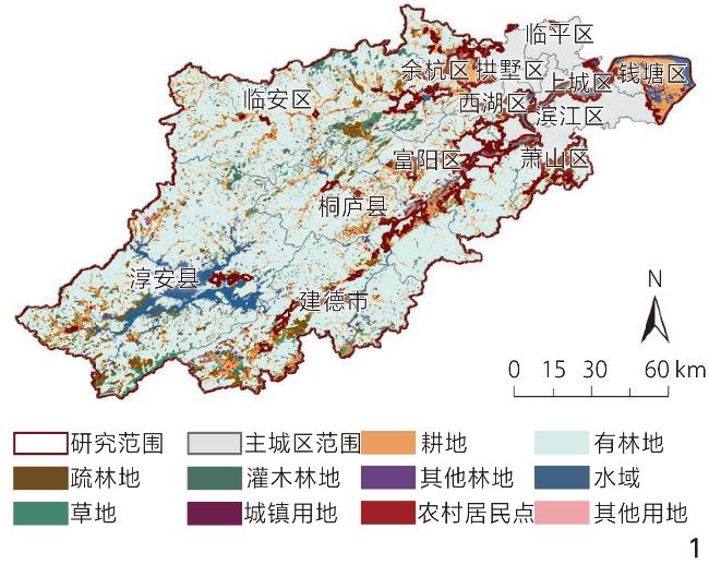
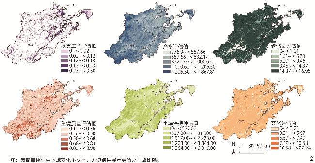
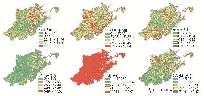
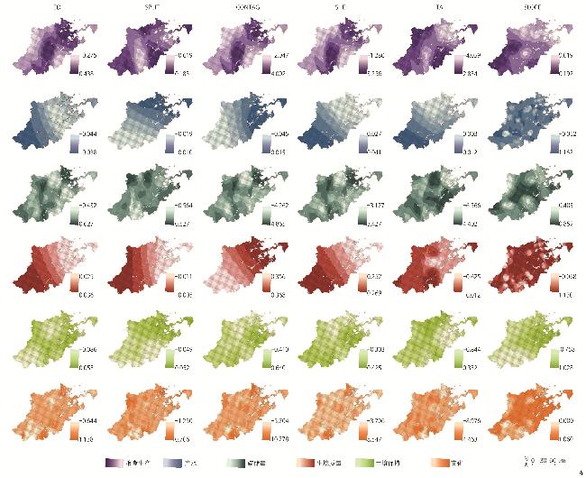
Objective Changes in landscape pattern often bring about alterations in the structure, process, and function of ecosystem. In the context of rapid urbanization, drastic changes in land use/land cover (LULC) significantly disturb the structure and function of rural landscapes, leading to a series of ecological and environmental issues in rural areas such as farmland transformation, landscape fragmentation, and habitat degradation. These issues, in turn, pose threats to the stability of ecosystem. Therefore, understanding the impact of rural landscape pattern on ecosystem service provision is fundamental for managing and planning rural ecosystem under rapid urbanization. In light of this, this research takes Hangzhou as an example to reveal the relationship between rural landscape pattern and ecosystem service under rapid urbanization, in hope of providing a reference value for local decision-makers in terms of land use, and a basis for planning and layout in the central and western regions of China that are about to undergo urbanization. Methods This research focuses on a typical area undergoing rapid urbanization — the rural area of Hangzhou, Zhejiang Province. This area has experienced dramatic changes in land use/land cover over the past 20 years, resulting in significant ecological issues such as habitat degradation and landscape fragmentation. The research employs models such as InVEST and Fragstats to assess ecosystem services (including food production, water yield, carbon sequestration, habitat support, soil conservation, and cultural services) in relation to rural landscape patterns. Spatial relationships between ecosystem service provision and rural landscape pattern within the research area are identified using OLS (ordinary least squares), GWR (geographically weighted regression), and MGWR (multiscale geographically weighted regression) models. Additionally, the performance of the MGWR model is compared with other global or local regression models. Results 1) The spatial pattern of ecosystem service function in the rural area of Hangzhou is closely related to land use type. Overall, woodland and grassland have a positive impact on ecosystem service, while arable land, residential area, and construction land have a negative impact. Additionally, water yield service is influenced not only by land use/cover type but also by factors such as climate and watershed runoff. 2) The rural landscape of Hangzhou is becoming increasingly fragmented and homogenized, with the most notable changes occurring in the plain area, while the mountainous and hilly areas are less affected by human interference. This is primarily due to the fact that human activities, such as urban expansion and scale-up of agricultural and forestry operations, have led to an increase in urban construction area and population density. These changes have altered the landscape pattern, contributing to a certain degree of fragmentation and complexity. 3) The impacts of rural landscape pattern on different ecosystem services vary, which is reflected in both landscape pattern indicators and their impact degrees. Landscape pattern indicators (slope degree, total landscape area, Shannon’s evenness index, edge density, and contagion) have a significant impact on ecosystem service, presenting a nonlinear relationship. However, the impacts of rural landscape pattern on different ecosystem services vary. Specifically, slope degree (SLOPE) has the most significant impact on ecosystem service, showing a strong positive correlation with the latter. This is followed by total landscape area (TA), Shannon’s evenness index (SHEI), edge density (ED), and contagion (CONTAG). 4) Here are optimization recommendations guided by the relationship between landscape pattern and ecosystem service. At the rural scale, ecosystem service can be optimized based on the influence strength of various landscape pattern indicators. For provisioning services, it is recommended to rationally optimize the layout of agricultural land to restrict the expansion of construction land and to promote high-level farmland protection. For regulating services, enhancing the connectivity of landscape patches can be achieved by restoring woodland, increasing water area, and strengthening vegetation cover. In terms of cultural services, planning should be optimized based on existing rural landscapes, and “agriculture+” and “ecology+” models should be explored to achieve a synergistic development of ecological and economic benefits. Conclusion This research is not a simple overlay of rural landscape pattern and ecosystem service. Rather, it distinguishes between the ecological conservation directions of rural landscapes and the priorities for regional development. It can serve as a theoretical basis for policy-making concerning ecosystem service and for the planning and management of rural landscape, aiming to achieve healthy and sustainable management of rural ecosystem services. Admittedly, the research has limitations: It models the relationship between landscape pattern and ecosystem service with 2.5 km × 2.5 km grid as the basic geographic analysis unit. In practical applications, spatial planning may require adjustments, potentially utilizing existing planning management units, such as the rural scale, and incorporating more influencing factors of ecosystem service to build a more comprehensive and integrated assessment framework. Additionally, temporal scale considerations should be included to understand the evolution and mechanism of rural ecosystem service provision under the pressure of urbanization. This approach will accurately reveal the complex relationships between ecosystem service and landscape pattern, and further advance the methods for rural landscape planning and design to better promote the sustainable development of rural living environment and regional development.
WANG Shuying , YANG Guofu , XU Yiren , XU Bin . Spatial Impact of Rural Landscape Pattern on Ecosystem Service in Hangzhou[J]. Landscape Architecture, 2025 , 32(4) : 125 -132 . DOI: 10.3724/j.fjyl.202406170326
表1 数据来源Tab. 1 Data sources |
| 数据名称 | 空间分辨率 | 数据来源 |
|---|---|---|
| 土地利用/覆被 | 30 m | 中国科学院资源与环境数据云平台(www.resdc.cn) |
| 植被归一化指数 | 30 m | 国家生态科学数据中心(www.nesdc.org.cn) |
| 气候数据(年降雨量、蒸散量)/mm | 1 km | 国家地球系统科学数据中心(www.geodata.cn) |
| 根系限制层深度/m | 1 mm | 世界土壤数据库(Harmonized World Soil Databas, HWSD)数据集 |
| 道路矢量数据(国道、省道、县道、乡道、铁路、高速公路) | / | 高德地图 |
| 降水侵蚀力因子/[MJ·mm/(hm2·h)] | 1 km | 国家地球系统科学数据中心(www.geodata.cn) |
| 土壤质地和土壤有机质数据 | 1 km | 世界土壤数据库 |
| 兴趣点数据 | / | 高德地图应用程序接口(application programming interface, API) |
表2 OLS模型和GWR模型参数结果对比Tab. 2 Comparison of parameter results between OLS model and GWR model |
| 生态系统服务类型 | OLS模型 | GWR模型 | |||
|---|---|---|---|---|---|
| R2 | 调整R2 | R2 | 调整R2 | ||
| 粮食生产 | 0.027 | 0.023 | 0.045 | 0.042 | |
| 产水 | 0.740 | 0.739 | 0.758 | 0.758 | |
| 碳储量 | 0.454 | 0.453 | 0.468 | 0.468 | |
| 生境质量 | 0.740 | 0.739 | 0.755 | 0.754 | |
| 土壤保持 | 0.753 | 0.752 | 0.767 | 0.766 | |
| 文化 | 0.757 | 0.757 | 0.771 | 0.770 | |
表3 GWR模型拟合结果Tab. 3 Fitting results of the GWR model |
| 因变量 | 自变量 | β | VIF | 因变量 | 自变量 | β | VIF |
|---|---|---|---|---|---|---|---|
| 粮食生产 (R2=0.042) | ED | 0.534 | 3.052 | 生境质量 (R2=0.754) | ED | 0.459 | 3.052 |
| SPLIT | 0.259 | 2.732 | SPLIT | 0.588 | 2.732 | ||
| CONTAG | 0.648 | 1.321 | CONTAG* | 0.034 | 1.321 | ||
| SHEI | 0.632 | 2.834 | SHEI | 0.077 | 2.834 | ||
| TA | 0.744 | 1.199 | TA* | 0.018 | 1.199 | ||
| SLOPE** | 0 | 1.020 | SLOPE** | 0.000 | 1.020 | ||
| 产水 (R2=0.758) | ED* | 0.034 | 3.052 | 土壤保持 (R2=0.766) | ED | 0.386 | 3.052 |
| SPLIT | 0.359 | 2.732 | SPLIT | 0.611 | 2.732 | ||
| CONTAG | 0.497 | 1.321 | CONTAG* | 0.042 | 1.321 | ||
| SHEI | 0.349 | 2.834 | SHEI* | 0.044 | 2.834 | ||
| TA | 0.616 | 1.199 | TA* | 0.022 | 1.199 | ||
| SLOPE** | 0.000 | 1.020 | SLOPE** | 0.000 | 1.020 | ||
| 碳储量 (R2=0.468) | ED | 0.462 | 3.052 | 文化 (R2=0.770) | ED | 0.118 | 3.052 |
| SPLIT | 0.294 | 2.732 | SPLIT | 0.264 | 2.732 | ||
| CONTAG | 0.135 | 1.321 | CONTAG* | 0.023 | 1.321 | ||
| SHEI | 0.100 | 2.834 | SHEI* | 0.023 | 2.834 | ||
| TA | 0.257 | 1.199 | TA* | 0.012 | 1.199 | ||
| SLOPE** | 0.000 | 1.020 | SLOPE** | 0.000 | 1.020 |
| [1] |
ZHOU Y, LI X H, LIU Y S. Land Use Change and Driving Factors in Rural China During the Period 1995−2015[J]. Land Use Policy, 2020, 99:105048
|
| [2] |
赵人镜, 刘家睿, 李雄. 2000—2020年国内外乡村景观研究热点[J]. 风景园林, 2022, 29(3):12-18.
ZHAO R J, LIU J R, LI X. Domestic and Foreign Research Hotspots on Rural Landscape (2000−2020)[J]. Landscape Architecture, 2022, 29(3):12-18.
|
| [3] |
ZHANG D H, JING P Q, SUN P J, et al. The Non-significant Correlation Between Landscape Ecological Risk and Ecosystem Services in Xi’an Metropolitan Area, China[J]. Ecological Indicators, 2022, 141:109118
|
| [4] |
WANG L Y, CHEN C, XIE F, et al. Estimation of the Value of Regional Ecosystem Services of an Archipelago Using Satellite Remote Sensing Technology: A Case Study of Zhoushan Archipelago, China[J]. International Journal of Applied Earth Observation and Geoinformation, 2021, 105:102616
|
| [5] |
YUAN M H, LO S L. Ecosystem Services and Sustainable Development: Perspectives from the Food-Energy-Water Nexus[J]. Ecosystem Services, 2020, 46:101217
|
| [6] |
WANG J Y, CAO Y, FANG X Q, et al. Identification of the Trade-Offs/Synergies Between Rural Landscape Services in a Spatially Explicit Way for Sustainable Rural Development[J]. Journal of Environmental Management, 2021, 300:113706
|
| [7] |
HAN Q, LI L, WEI H J, et al. Identifying the Relationships Between Landscape Pattern and Ecosystem Service Value from a Spatiotemporal Variation Perspective in a Mountain − Hill − Plain Region[J]. Forests, 2023, 14(12):2446
|
| [8] |
WEI L, LUO Y, WANG M, et al. Essential Fragmentation Metrics for Agricultural Policies: Linking Landscape Pattern, Ecosystem Service and Land Use Management in Urbanizing China[J]. Agricultural Systems, 2020, 182:102833
|
| [9] |
LIN X, WANG Z T. Landscape Ecological Risk Assessment and Its Driving Factors of Multi-mountainous City[J]. Ecological Indicators, 2023, 146:109823
|
| [10] |
TANG Z L, WANG Y T, FU M, et al. The Role of Land Use Landscape Patterns in the Carbon Emission Reduction: Empirical Evidence from China[J]. Ecological Indicators, 2023, 156:111176
|
| [11] |
杨佳明, 安睿, 仝照民, 等. 基于多尺度地理加权回归的建成环境对通风潜力的影响研究: 以武汉市主城区为例[J]. 南京师大学报(自然科学版), 2023, 46(4):29-39.
YANG J M, AN R, TONG Z M, et al. Exploring the Relationship Between Built Environment and Ventilation Potential in Wuhan: A Multi-scale Geographically Weighted Regression Analysis[J]. Journal of Nanjing Normal University (Natural Science Edition), 2023, 46(4):29-39.
|
| [12] |
DEGEFU M A, ARGAW M, FEYISA G L, et al. Dynamics of Urban Landscape Nexus Spatial Dependence of Ecosystem Services in Rapid Agglomerate Cities of Ethiopia[J]. Science of The Total Environment, 2021, 798:149192
|
| [13] |
TRAN D X, PEARSON D, PALMER A, et al. Quantifying Spatial Non-stationarity in the Relationship Between Landscape Structure and the Provision of Ecosystem Services: An Example in the New Zealand Hill Country[J]. Science of The Total Environment, 2022, 808:152126
|
| [14] |
徐建英, 樊斐斐, 刘焱序, 等. 汶川县生态系统服务对景观格局及其变化的响应[J]. 生态学报, 2020, 40(14):4724-4736.
徐建英, 樊斐斐, 刘焱序, 等. 汶川县生态系统服务对景观格局及其变化的响应[J]. 生态学报, 2020, 40(14):4724-4736.
|
| [15] |
EGARTER VIGL L, SCHIRPKE U, TASSER E, et al. Linking Long-Term Landscape Dynamics to the Multiple Interactions Among Ecosystem Services in the European Alps[J]. Landscape Ecology, 2016, 31(9):1903-1918.
|
| [16] |
胡金龙, 郑文俊, 王影雪. 漓江流域景观格局演变对生态系统服务价值的影响[J]. 风景园林, 2020, 27(10):64-70.
HU J L, ZHENG W J, WANG Y X. Impact of Landscape Pattern Evolution on Ecosystem Services Value in Lijiang River Basin[J]. Landscape Architecture, 2020, 27(10):64-70.
|
| [17] |
KREMER P, HAMSTEAD Z A, MCPHEARSON T. The Value of Urban Ecosystem Services in New York City: A Spatially Explicit Multicriteria Analysis of Landscape Scale Valuation Scenarios[J]. Environmental Science & Policy, 2016, 62:57-68.
|
| [18] |
刘志涛, 王少剑, 方创琳. 粤港澳大湾区生态系统服务价值的时空演化及其影响机制[J]. 地理学报, 2021, 76(11):2797-2813.
LIU Z T, WANG S J, FANG C L. Spatiotemporal Evolution and Influencing Mechanism of Ecosystem Service Value in the Guangdong − Hong Kong − Macao Greater Bay Area[J]. Acta Geographica Sinica, 2021, 76(11):2797-2813.
|
| [19] |
LI S N, HE Y Y, XU H L, et al. Impacts of Urban Expansion Forms on Ecosystem Services in Urban Agglomerations: A Case Study of Shanghai − Hangzhou Bay Urban Agglomeration[J]. Remote Sensing, 2021, 13(10):1908
|
| [20] |
XU S N, LIU Y F, WANG X, et al. Scale Effect on Spatial Patterns of Ecosystem Services and Associations Among Them in Semi-arid Area: A Case Study in Ningxia Hui Autonomous Region, China[J]. Science of The Total Environment, 2017, 598:297-306.
|
| [21] |
ZHAO J L, LIU S G, WANG Z, et al. The Impact of Land Use and Landscape Pattern on Ecosystem Services in the Dongting Lake Region, China[J]. Remote Sensing, 2023, 15(9):2228
|
| [22] |
YUN J , LIU H M, XU Z C, et al. Assessing Changes in the Landscape Pattern of Wetlands and Its Impact on the Value of Wetland Ecosystem Services in the Yellow River Basin, Inner Mongolia[J]. Sustainability, 2022, 14(10):6328
|
| [23] |
NELSON K S, BURCHFIELD E K. Landscape Complexity and US Crop Production[J]. Nature Food, 2021, 2(5):330-338.
|
| [24] |
柳迪子, 杜守帅, 王晨旭. 旅游型乡村景观格局变化及生态系统服务价值响应[J]. 水土保持通报, 2021, 41(5):264-275.
LIU D Z, DU S S, WANG C X. Landscape Pattern Change and Its Response to Ecosystem Services Value in A Rural Tourism Area[J]. Bulletin of Soil and Water Conservation, 2021, 41(5):264-275.
|
| [25] |
XU T, NIE W B, WANG Z G, et al. Research on the Coupled Mechanism of Landscape Connectivity Simulation by Integrating Multi-level Ecological Security Patterns and Multi-scenario Simulation: A Case Study of the Main Urban Area of Hangzhou[J]. Land Degradation & Development, 2024, 38(5):2716-2737.
|
| [26] |
LIU Z Y, LIU L J, LI Y, et al. Influence of Urban Green Space Landscape Pattern on River Water Quality in A Highly Urbanized River Network of Hangzhou City[J]. Journal of Hydrology, 2023, 621:129602
|
| [27] |
ZHOU T Y, LIU H M, GOU P, et al. Conflict or Coordination? Measuring the Relationships Between Urbanization and Vegetation Cover in China[J]. Ecological Indicators, 2023, 147:109993
|
| [28] |
张淑怡, 尤怡靖, 朱泓恺, 等. 长三角地区植被覆盖演变城乡差异及其原因[J]. 生态学报, 2023, 43(14):5980-5993.
ZHANG S Y, YOU Y J, ZHU H K, et al. Urban and Rural Differences in Vegetation Cover Evolution and Its Causes in the Yangtze River Delta[J]. Acta Ecologica Sinica, 2023, 43(14):5980-5993.
|
| [29] |
YANG L A, LI Y L, JIA L J, et al. Ecological Risk Assessment and Ecological Security Pattern Optimization in the Middle Reaches of the Yellow River Based on ERI+MCR Model[J]. Journal of Geographical Sciences, 2023, 33(4):823-844.
|
| [30] |
GAO X X, XIAO F J, LIU Q F, et al. Evolution of Ecosystem Services Under the Impact of Urbanization Using the InVEST Model in the Xiongan New Area, China[J]. Environmental Research Communications, 2024, 6(3):035021
|
| [31] |
范逸凡, 王珂, 黄璐. 乡村地区生态系统服务权衡与协同关系: 以湖州市为例[J]. 生态学报, 2022, 42(17):6875-6887.
FAN Y F, WANG K, HUANG L. Trade-Offs and Synergies of Ecosystem Services in Rural Areas: A Case Study of Huzhou[J]. Acta Ecologica Sinica, 2022, 42(17):6875-6887.
|
| [32] |
夏敏, 季晓垭, 邹伟, 等. 新农村建设中高速城镇化地区景观格局与生态系统服务的关联效应[J]. 长江流域资源与环境, 2024, 33(5):982-992.
XIA M, JI X Y, ZOU W, et al. Correlation Effect Between Landscape Pattern and Ecosystem Services in High-Speed Urbanization Areas in New Rural Construction[J]. Resources and Environment in the Yangtze Basin, 2024, 33(5):982-992.
|
| [33] |
李志英, 李媛媛, 薛梦柯, 等. 昆明市景观格局变化及其生态环境效应研究[J]. 西南林业大学学报(自然科学), 2023, 43(4):152-163.
LI Z Y, LI Y Y, XUE M K, et al. The Change of Landscape Pattern and Its Ecological Environment Effect in Kunming[J]. Journal of Southwest Forestry University (Natural Sciences), 2023, 43(4):152-163.
|
| [34] |
DENG L Y, ZHANG Q, CHENG Y, et al. Underlying the Influencing Factors Behind the Heterogeneous Change of Urban Landscape Patterns Since 1990: A Multiple Dimension Analysis[J]. Ecological Indicators, 2022, 140:108967
|
| [35] |
RONG Y, LI K, GUO J, et al. Multi-scale Spatio-Temporal Analysis of Soil Conservation Service Based on MGWR Model: A Case of Beijing − Tianjin − Hebei, China[J]. Ecological Indicators, 2022, 139:108946
|
| [36] |
ZOU X Y, WANG C, QUE X, et al. Spatiotemporal Heterogeneous Responses of Ecosystem Services to Landscape Patterns in Urban-Suburban Areas[J]. Sustainability, 2024, 16(8):3260
|
| [37] |
王丽群, 张志强, 李格, 等. 北京边缘地区景观格局变化及对生态系统服务的影响评价: 以牛栏山-马坡镇为例[J]. 生态学报, 2018, 38(3):750-759.
WANG L Q, ZHANG Z Q, LI G, et al. Landscape Pattern Change in Beijing Fringe Area and Its Impact on the Ecosystem Services: A Case Study in Niulanshan−Mapo Town[J]. Acta Ecologica Sinica, 2018, 38(3):750-759.
|
| [38] |
MARTIN E A, DAINESE M, CLOUGH Y, et al. The Interplay of Landscape Composition and Configuration: New Pathways to Manage Functional Biodiversity and Agroecosystem Services Across Europe[J]. Ecology Letters, 2019, 22(7):1083-1094.
|
| [39] |
XUE C L, CHEN X H, XUE L R, et al. Modeling the Spatially Heterogeneous Relationships Between Tradeoffs and Synergies Among Ecosystem Services and Potential Drivers Considering Geographic Scale in Bairin Left Banner, China[J]. Science of The Total Environment, 2023, 855:158834
|
| [40] |
LIU C G, SUN W, LI MAN. Evolution of Ecosystem Service Value in Rural Regions Based on Geographical Scope of Entities: A Case Study of Nanjing, China[J]. Ecological Informatics, 2021, 64:101368
|
| [41] |
FABIO J B, PUNEET D, SUSANA F, et al. Trade-Offs Between the Value of Ecosystem Services and Connectivity Among Protected Areas in the Upper Chattahoochee[J]. Watershed. Environ Manage, 2022, 69:937-951.
|
| [42] |
HASAN S S, LIN Z, MIAH G MD, et al. Impact of Land Use Change on Ecosystem Services: A Review[J]. Environmental Development, 2020, 34:100527
|
/
| 〈 |
|
〉 |