
Rural Landscape Characters and Spatial Correlation Mechanism in the Tiaoxi River – Canal Basin in Zhejiang Province
|
ZHANG Lin, Ph.D., is an associate professor and doctoral supervisor in the College of Architecture and Urban Planning (CAUP), Tongji University. Her research focuses on landscape planning and design, and landscape architecture and tourism planning |
|
ZUO You is a Ph.D. candidate in the College of Architecture and Urban Planning (CAUP), Tongji University. Her research focuses on landscape planning and design |
|
LIU Binyi, Ph.D., is a professor and doctoral supervisor in the College of Architecture and Urban Planning (CAUP), Tongji University, convenor of the 8th landscape architecture discipline appraisal group of the State Council Academic Degree Committee, a distinguished professor and doctoral supervisor in the Faculty of Humanities and Arts, Macau University of Science and Technology, and an editorial board member of this journal. His research focuses on history and theory of landscape architecture, visual evaluation of landscape, green space system planning, and landscape architecture and tourism planning and design |
Received date: 2024-07-31
Revised date: 2025-02-26
Online published: 2025-12-14
Copyright
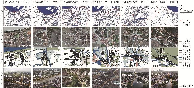
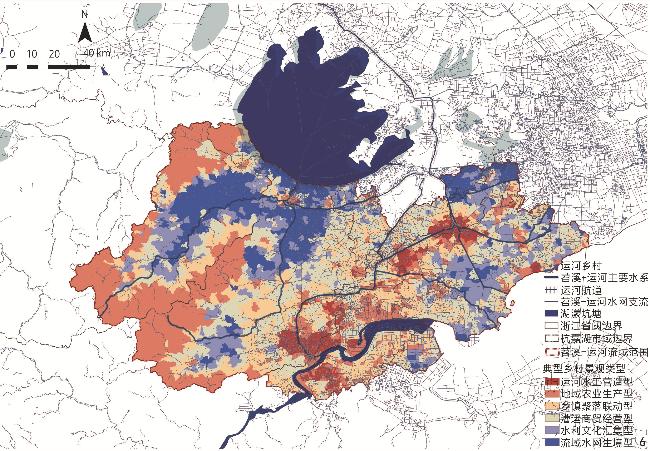
Objective Rural landscape in the Jiangnan Canal Basin is characterized by a synergistic symbiosis of water basin habitats, canal water conservancy and transportation, and rural settlement construction. Based on the perspective of the correlation and coupling of water network − canal channel − rural landscape, this research aims to explore the types of rural landscape characters and spatial coupling patterns in the Jiangnan Canal Basin, so as to ensure that rural landscape continues to play a significant role in the protection of regional historical heritage and the resilient development of urban and rural areas within the basin. Methods The research selects the Tiaoxi River − Canal Basin in Zhejiang Province, which is closely connected to the Jiangnan Canal, as the research object. At the river − canal basin scale, the multi-level spatial superposition technique is utilized to identify associative character zones, and a coupling coordination model is used to identify the correlation patterns of water network, canal channel and rural landscape. At the rural community scale, through spatial maximum expectation (EM) clustering, the types of rural landscape characters are classified and spatially mapped through simulation algorithms. Results In terms of the spatial correlation of water network − canal channel − rural landscape within the Tiaoxi River − Canal Basin, the research identifies three major landscape character zones including the West Tiaoxi River − Ditang Canal Basin, East Tiaoxi River − Jiangnan Canal Basin, and Hangzhoutang River − Hangzhou − Jiaxing Canal Basin. In terms of the coupling pattern of water network – canal channel – rural landscape in the Tiaoxi River Canal Basin, the coupling and coordination degree between the East and West Tiaoxi River Basin and the buffer zone along the Jiangnan Canal is generally high, and the that in the west area dominated by natural water system is stronger than that in the east area dominated by canal channel. In the main river basin of the East Tiaoxi River – Jiangnan Canal, there are coupling cold spots at the gathering places of canal towns such as Jiaxing and Hangzhou, and there are significant disturbances in the coupling of the landscape system. In terms of typical rural landscape types in the Tiaoxi River – Canal Basin, six types of rural landscape paradigms are identified, including the canal hydraulic engineering, regional agricultural production, township community linkage, canal trade operation, water conservancy culture collection and water network habitat maintenance types. And significant region − basin differences are explored from the perspectives of spatial proportion, layout pattern, and coupling relationship. At the level of the spatial correlation mechanism of typical rural landscapes, the regional agricultural production and township community linkage types of landscape occupy a relatively large proportion, accounting for 24.49% and 21.89% respectively, while the water conservation culture collection and water network habitat maintenance types of landscape occupy a relatively small proportion, accounting for 12.88% and 10.60% respectively. At the level of spatial transformation from the overall scale of basin as a whole to the individual scale of rural settlements, the canal hydraulic engineering and township community linkage types of landscape are mainly distributed in the East Tiaoxi River and the Hangzhoutang River water network basin, the regional agricultural production type of landscape is mainly distributed in the West Tiaoxi River − Ditang Canal Basin, and the water network habitat maintenance type of landscape is mainly distributed in the connection area between the main veins of the East and West Tiaoxi River systems and the tributaries of the Hangzhou − Jiaxing Canal. The canal trade operation and water conservation culture collection types of landscape are mainly distributed in the East Tiaoxi River − Jiangnan Canal Basin and the Hangzhoutang River − Hangzhou − Jiaxing Canal Basin. From the perspective of coupling mechanism, the spatial coupling degrees of the regional agricultural production and township community linkage types of landscape are relatively high in the West Tiaoxi River − Ditang Canal Basin, with mean values of 0.731 and 0.775, respectively; while the mean value of the canal hydraulic engineering type is only 0.596, relatively low. Conclusion The research delves into the underlying mechanisms that interlink the water network, canal channel and rural landscape within the human settlement system of the Jiangnan Canal Basin. The research clarifies the stratified compositional elements, the superposition of character zoning, the predominant correlation types, and the coupling mechanisms of rural landscape. The research delineates landscape character zones at the canal basin scale and identifies the dominant types of rural landscapes at the scale of rural settlements. Building on these findings, the research achieves a basin-scale spatial inversion of rural landscape types. Furthermore, the research establishes a research paradigm for examining the characters, spatial distribution and mechanisms of rural landscapes within the canal basin. The research offers resilient planning insights that integrate trans-basin zone governance, multi-type system linkage, and multi-level network construction, providing a comprehensive approach to the management and conservation of canal heritage and rural landscapes. Future research will construct a spatio-temporal dynamic dataset of canal heritage landscapes, which aims to enhance the fine-grained character extraction and type classification accuracy of machine learning algorithm models for rural landscapes. Additionally, the universal applicability of the stratified correlation perspective in the field of rural landscape research within the context of the Grand Canal Basin will also be explored.
ZHANG Lin , ZUO You , LIU Binyi . Rural Landscape Characters and Spatial Correlation Mechanism in the Tiaoxi River – Canal Basin in Zhejiang Province[J]. Landscape Architecture, 2025 , 32(4) : 21 -30 . DOI: 10.3724/j.fjyl.202407310424
表1 苕溪-运河流域乡村景观关联指标因子中心度Tab. 1 centrality of correlation index factors of rural landscape in theTiaoxi River − Canal Basin |
| 关联指标因子 | 乡村景观类型 | |||||
|---|---|---|---|---|---|---|
| 运河水工 营造型 | 地域农业 生产型 | 乡镇聚落 联动型 | 漕运商贸 经营型 | 水利文化 汇集型 | 流域水网 生境型 | |
| 注:表格颜色越深,表示关联指标因子中心度越强。 | ||||||
| 乡村运河非遗密度 | 0.836 | 0.766 | 0.741 | 0.842 | 0.989 | 0.387 |
| 乡村景观格局聚集度 | 0.581 | 0.895 | 0.989 | 0.965 | 0.377 | 0.989 |
| 乡村土地利用度 | 0.422 | 0.989 | 0.952 | 0.901 | 0.761 | 0.541 |
| 乡村聚落密度 | 0.697 | 0.962 | 0.887 | 0.794 | 0.878 | 0.939 |
| 运河文化遗产密度 | 0.978 | 0.777 | 0.832 | 0.895 | 0.974 | 0.711 |
| 运河航道联通度 | 0.904 | 0.549 | 0.965 | 0.989 | 0.762 | 0.801 |
| 运河水利设施密度 | 0.986 | 0.979 | 0.989 | 0.754 | 0.871 | 0.691 |
| 运河河网欧氏距离 | 0.859 | 0.823 | 0.762 | 0.911 | 0.938 | 0.747 |
| 河湖水面率 | 0.937 | 0.901 | 0.979 | 0.766 | 0.662 | 0.931 |
| 河网密度 | 0.676 | 0.953 | 0.692 | 0.762 | 0.779 | 0.993 |
| 地势坡度 | 0.979 | 0.987 | 0.971 | 0.731 | 0.572 | 0.933 |
| 地形高程 | 0.751 | 0.931 | 0.801 | 0.887 | 0.892 | 0.986 |
表2 苕溪-运河流域乡村景观类型分区统计Tab. 2 Zoning-based statistics of rural landscape types in the Tiaoxi River − Canal Basin |
| 苕溪-运河流域 乡村景观类型 | 苕溪-运河流域乡村景观特征分区 | |||||||
|---|---|---|---|---|---|---|---|---|
| 西苕溪-頔塘运河流域 | 东苕溪-江南运河流域 | 杭州塘-杭嘉运河流域 | ||||||
| 乡村聚落数量 | 水-运-村耦合 协调度 | 乡村聚落数量 | 水-运-村耦合 协调度 | 乡村聚落数量 | 水-运-村耦合 协调度 | |||
| 运河水工营造型 | 5 | 0.696 | 387 | 0.500 | 352 | 0.592 | ||
| 地域农业生产型 | 253 | 0.805 | 294 | 0.680 | 353 | 0.709 | ||
| 乡镇聚落联动型 | 92 | 0.852 | 388 | 0.746 | 388 | 0.726 | ||
| 漕运商贸经营型 | 100 | 0.812 | 335 | 0.760 | 205 | 0.794 | ||
| 水利文化汇集型 | 111 | 0.869 | 135 | 0.801 | 165 | 0.839 | ||
| 流域水网生境型 | 201 | 0.853 | 87 | 0.843 | 79 | 0.777 | ||
文中图表均由作者绘制,其中图1~4、6~7使用自然资源部提供标准地图进行改绘,未对行政边界进行修改,审图号:浙S(2023)1号。
| [1] |
刘滨谊. 三元论: 人类聚居环境学的哲学基础[J]. 规划师, 1999, 15(2):81-84.
LIU B Y. Trialism: The Philosophical Basis for Studies of Human Inhabitation Environment[J]. Planners, 1999, 15(2):81-84.
|
| [2] |
张琳, 苗晏凯, 朱莉梅, 等. 国土空间治理视角下浙江传统村落与自然景观耦合的地方性特征研究[J]. 中国园林, 2023, 39(4):20-26.
ZHANG L, MIAO Y K, ZHU L M, et al. Natural Landscape Associated Features and Localities of Zhejiang Traditional Villages from the Perspective of Territorial Spatial Governance[J]. Chinese Landscape Architecture, 2023, 39(4):20-26.
|
| [3] |
汪芳, 安黎哲, 党安荣, 等. 黄河流域人地耦合与可持续人居环境[J]. 地理研究, 2020, 39(8):1707-1724.
WANG F, AN L Z, DANG A R, et al. Human-Land Coupling and Sustainable Human Settlements in the Yellow River Basin[J]. Geographical Research, 2020, 39(8):1707-1724.
|
| [4] |
王云才, 刘滨谊. 论中国乡村景观及乡村景观规划[J]. 中国园林, 2003, 19(1):56-59.
WANG Y C, LIU B Y. Discussions on Rural Landscape and Rural Landscape Planning in China[J]. Chinese Landscape Architecture, 2003, 19(1):56-59.
|
| [5] |
中共中央办公厅, 国务院办公厅. 大运河文化保护传承利用规划纲要[EB/OL].(2019-05-09)[2023-10-01].https://www.gov.cn/zhengce/2019-05/09/content_5390046.htm.
General Office of the Central Committee of the Communist Party of China, General Office of the State Council. Outline of the Plan for the Protection, Inheritance, and Utilization of the Grand Canal Culture[EB/OL].(2019-05-09)[2023-10-01].https://www.gov.cn/zhengce/2019-05/09/content_5390046.htm.
|
| [6] |
董卫, 柴洋波, 王沈玉, 等. 江南文明背景下的运河遗产保护: 由大运河产业遗产保护引发的一些思考[J]. 城市规划, 2010, 34(7):44-47.
DONG W, CHAI Y B, WANG S Y, et al. Cultural Values Assessment of the Canal Under the Historical Context of Jiangnan Civilization: Holistic Conservation Approach on Heritage of the Grand Canal[J]. City Planning Review, 2010, 34(7):44-47.
|
| [7] |
袁康, 吴平. 吴地传[M].袁康, 吴平.越绝书. 北京: 商务印书馆, 1956.
YUAN K, WU P. Biography of the Wu Region[M].YUAN K, WU P. The Yuejue Shu. Beijing: The Commercial Press, 1956.
|
| [8] |
蔡绍江. 漕运河道图考[M].白帆, 点校. 北京: 文津出版社, 2023.
CAI S J. Study on the Canal Map of Water Transport[M].BAI F, proofreaded. Beijing: Wenjin Publishing House, 2023.
|
| [9] |
王云才, 陈田, 郭焕成. 江南水乡区域景观体系特征与整体保护机制[J]. 长江流域资源与环境, 2006, 15(6):708-712.
WANG Y C, CHEN T, GUO H C. Mechanisms in Conservation of Regional Landscape System for Ancient Water Towns in the Southern Yangtze River Area[J]. Resources and Environment in the Yangtze Basin, 2006, 15(6):708-712.
|
| [10] |
常媛, 郭巍. 浙东运河姚江河谷段运河系统与聚落景观研究[J]. 风景园林, 2020, 27(11):16-22.
CHANG Y, GUO W. Research on Canal System and Settlement Landscape of Yaojiang River Valley in Zhedong Canal[J]. Landscape Architecture, 2020, 27(11):16-22.
|
| [11] |
王建波. 江南运河古镇-塘栖古镇国家历史文化名城研究中心历史街区调研[J]. 城市规划, 2010, 34(3):103-104.
WANG J B. Jiangnan Canal Ancient Town: Research on Tangqi Ancient Town Historical Blocks of National Historical and Cultural City Research Center[J]. Urban Planning, 2010, 34(3):103-104.
|
| [12] |
许广通, 何依, 殷楠, 等. 发生学视角下运河古村的空间解析及保护策略: 以浙东运河段半浦古村为例[J]. 现代城市研究, 2018, 33(7):77-85.
XU G T, HE Y, YIN N, et al. Spatial Analysis and Protection Strategy of Canal Ancient Villages from the Perspective of Phylogenetics: A Case Study of Banpu Ancient Village Along the Grand Canal in East Zhejiang[J]. Modern Urban Research, 2018, 33(7):77-85.
|
| [13] |
段进, 邵润青, 兰文龙, 等. 空间基因[J]. 城市规划, 2019, 43(2):14-21.
DUAN J, SHAO R Q, LAN W L, et al. Space Gene[J]. City Planning Review, 2019, 43(2):14-21.
|
| [14] |
李伟, 俞孔坚, 李迪华. 遗产廊道与大运河整体保护的理论框架[J]. 城市问题, 2004(1):28-31.
LI W, YU K J, LI D H. Heritage Corridor and a Primary Theoretic Framework on Study of Integrated Conservation of the Great Canal[J]. Urban Problems, 2004(1):28-31.
|
| [15] |
张诗阳, 王滨鹭, 金爱博. 空间整体性视角下大运河环境关联机制解析与规划启示研究: 以浙东运河为例[J]. 中国园林, 2023, 39(8):43-49.
ZHANG S Y, WANG B L, JIN A B. Research on the Environmental Linkage Mechanism of the Grand Canal and Its Planning Enlightenment from the Spatial Integrity Perspective: Taking the Zhedong Canal as an Example[J]. Chinese Landscape Architecture, 2023, 39(8):43-49.
|
| [16] |
霍艳虹, 曹磊, 杨冬冬. 京杭大运河“文化基因” 的提取与传承路径理论探析[J]. 建筑与文化, 2017(2):59-62.
HUO Y H, CAO L, YANG D D. Theory Analysis of the Culture Gene Extraction and Transmission Path of Beijing-Hangzhou Grand Canal[J]. Architecture & Culture, 2017(2):59-62.
|
| [17] |
CARYS S. Landscape Character Assessment: Guidance for England and Scotland[R]. London: Natural England, 2002.
|
| [18] |
王云才, 陈照方, 成玉宁. 新时期乡村景观特征与景观性格的表征体系构建[J]. 风景园林, 2021, 28(7):107-113.
WANG Y C, CHEN Z F, CHENG Y N. The Representation System of Rural Landscape Character and Personality in the New Era[J]. Landscape Architecture, 2021, 28(7):107-113.
|
| [19] |
LIGHTFOOT D R, FINCHUM A, VADJUNEC J M, et al. Traditional Environmental Knowledge and Transport Efficiency of a Communal Canal Network, Tafilalt Oasis, Morocco: A Historical GIS Analytics Perspective[J]. Journal of Historical Geography, 2023, 80:79-93.
|
| [20] |
杨玉冰, 倪可心, 郭巍, 等. 基于K-Means聚类算法的灌区人居景观特征研究分析: 以世界灌溉工程遗产东风堰为例[J]. 西部人居环境学刊, 2023, 38(2):77-84.
YANG Y B, NI K X, GUO W, et al. Research and Analysis of Habitat Landscape Features in Irrigation Areas Based on K-Means Clustering Algorithm: Taking the World Heritage Irrigation Structures Dongfeng Weir as an Example[J]. Journal of Human Settlements in West China, 2023, 38(2):77-84.
|
| [21] |
张廷玉, 等. 明史·河渠志: 卷六十三 运河下[M]. 北京: 中华书局, 1974.
ZHANG T Y, et al. Ming History, Hequ Chronicles: Volume 63, Grand Canal[M]. Beijing: Zhonghua Book Company, 1974.
|
| [22] |
《苕溪运河志》编纂委员会. 苕溪运河志[M]. 北京: 中国水利水电出版社, 2010.
The Compilation Committee of Chronicles of Tiaoxi Canal. Chronicles of Tiaoxi Canal[M]. Beijing: China Water & Power Press, 2010.
|
| [23] |
阮仪三, 王建波. 京杭大运河的申遗现状、价值和保护[J]. 中国名城, 2009, 23(9):8-15.
RUAN Y S, WANG J B. Present State, Value and Protection of the Heritage Declaration of Jinghang Canal Ruan Yisan[J]. China Ancient City, 2009, 23(9):8-15.
|
| [24] |
郑学檬. 宋代两浙围湖垦田之弊: 读《宋会要辑稿》“食货”“水利” 笔记[J]. 中国社会经济史研究, 1982(3):88-91.
ZHENG X M. Disadvantages of Encircling Lakes and Cultivating Fields in the Two Zhejiang Provinces During the Song Dynasty: Notes on "Food and Goods" and "Water Conservancy" in the Essentials of the Song Conference[J]. The Journal of Chinese Social and Economic History, 1982(3):88-91.
|
| [25] |
王建革, 周晴. 宋元时期江南运河对嘉湖平原圩田体系的影响[J]. 风景园林, 2019, 26(12):21-27.
WANG J G, ZHOU Q. Influence of Jiangnan Canal on Jiaxing and Huzhou Plain’s Polder System in Song and Yuan Dynasties[J]. Landscape Architecture, 2019, 26(12):21-27.
|
| [26] |
孙瑾璐, 王晴, 郭巍. 西苕溪流域㘰-圩田传统人居体系成因及特征[J]. 风景园林, 2024, 31(1):64-70.
SUN J L, WANG Q, GUO W. Origin and Characteristics of the Traditional Dike-Polder Human Settlement System of Xitiaoxi Watershed[J]. Landscape Architecture, 2024, 31(1):64-70.
|
| [27] |
汪芳, 胡文颖, 高晨舸. 韧性视角下大运河沿线水陆交通网络与城市的耦合演变[J]. 风景园林, 2021, 28(7):31-38.
WANG F, HU W Y, GAO C G. The Coupling and Evolution of Water and Land Transportation Network and Urban Settlements Along the Grand Canal from the Perspective of Resilience[J]. Landscape Architecture, 2021, 28(7):31-38.
|
| [28] |
徐光来, 许有鹏, 王柳艳. 近50年杭—嘉—湖平原水系时空变化[J]. 地理学报, 2013, 68(7):966-974.
XU G L, XU Y P, WANG L Y. Temporal and Spatial Changes of River Systems in Hangzhou – Jiaxing – Huzhou Plain During 1960s−2000s[J]. Acta Geographica Sinica, 2013, 68(7):966-974.
|
| [29] |
涂宇倩, 张婧雅. 层积视角下武夷山国家公园文化景观特征识别[J]. 风景园林, 2024, 31(1):71-79.
TU Y Q, ZHANG J Y. Identification of Characters of Cultural Landscape in Wuyishan National Park from the Perspective of Stratification[J]. Landscape Architecture, 2024, 31(1):71-79.
|
| [30] |
MORZILLO A T, DE BEURS K M, MARTIN-MIKLE C J. A Conceptual Framework to Evaluate Human-Wildlife Interactions Within Coupled Human and Natural Systems[J]. Ecology and Society, 2014, 19(3):44
|
| [31] |
丁玉琦, 邵振峰, 胡石元. 一种云模型和期望最大聚类的遥感影像分割算法[J]. 武汉大学学报(信息科学版), 2015, 40(6):721-726.
DING Y Q, SHAO Z F, HU S Y. Combined with Cloud Model and EM Clustering for Remote Sensing Image Segmentation[J]. Geomatics and Information Science of Wuhan University, 2015, 40(6):721-726.
|
| [32] |
付孟泽, 闫凤英, 林建桃. 人地关系驱动下浙北乡村聚落空间演变与发展研究[J]. 地域研究与开发, 2019, 38(6):152-157.
FU M Z, YAN F Y, LIN J T. Study on Spatial Evolution and Development of Northern Zhejiang Rural Settlements Driven by Human-Land Relationship[J]. Areal Research and Development, 2019, 38(6):152-157.
|
| [33] |
缪启愉. 太湖地区塘浦圩田的形成和发展[J]. 中国农史, 1982, 1(1):12-32.
MIAO Q Y. The Formation and Development of Tangpu Polder Fields in the Taihu Lake Lake Area[J]. Agricultural History of China, 1982, 1(1):12-32.
|
| [34] |
崔子淇, 郭巍. 长三角沙地圩田类型分布识别与形态特征分析[J]. 风景园林, 2023, 30(7):117-124.
CUI Z Q, GUO W. Type Distribution Identification and Morphological Characteristic Analysis of the Sand Flat Polders in the Yangtze River Delta[J]. Landscape Architecture, 2023, 30(7):117-124.
|
| [35] |
蒋鑫, 郭巍, 张文海, 等. 城运相依: 运河影响下淮扬沿运城镇传统空间范式演进与驱动机制研究[J]. 城市发展研究, 2021, 28(11):76-84.
JIANG X, GUO W, ZHANG W H, et al. Coexist with Canal: Research on the Evolution and Driving Mechanism of Traditional Space Paradigm in Towns Along the Huaiyang Canal Under the Influence of Canal[J]. Urban Development Studies, 2021, 28(11):76-84.
|
/
| 〈 |
|
〉 |