
Strategies for Construction and Optimization of the Ecological Security Pattern for Human Settlements in the Wuding River Basin
|
WANG Xiaomeng (Mogol), Master, is an assistant engineer in the Institute of Urban and Rural Planning, China Academy of Building Research. Her Research focuses on urban planning pathways under the carbon peaking and carbon neutrality goals, and ecological planning of landscape architecture |
|
DANG Anrong, Ph.D., is professor in the School of Architecture, Tsinghua University. His research focuses on science and technology in urban and rural planning, digital heritage preservation, and smart city planning |
|
TONG Biao, Ph.D., is an associate professor in Liaoning Provincial College of Communications. His research focuses on urban and rural planning |
|
LIU Xinyi, Master, in an assistant planner in the Institute of Culture and Tourism Planning, China Academy of Urban Planning & Design. Her Research focuses on landscape analysis of cultural ecological reserves |
Received date: 2025-02-14
Revised date: 2025-03-14
Online published: 2025-12-14
Copyright
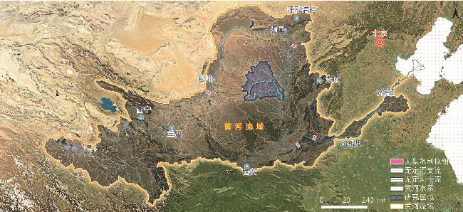
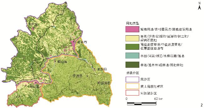
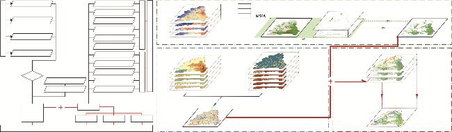
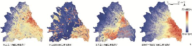
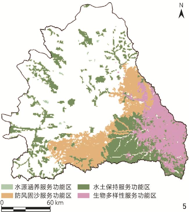
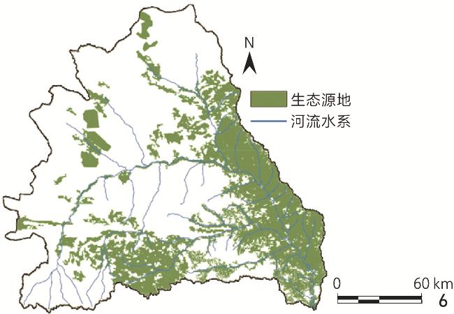
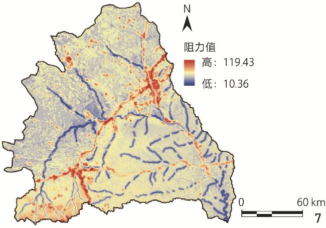
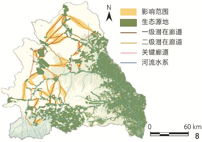
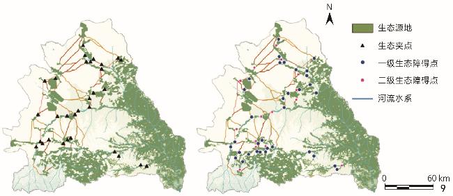
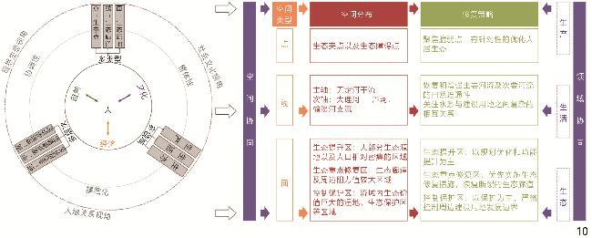
Objective The Wuding River is a key tributary of the middle reaches of the Yellow River, and the Wuding River Basin has undergone rapid urban and township expansion since 1998, leading to increased fragmentation of its human settlement ecosystem. Over the past two decades, growing ecological concerns in the Yellow River Basin have driven extensive restoration efforts in the Wuding River Basin. While large-scale interventions have achieved notable results, sustaining these improvements remains a challenge. Given the basin’s fragile ecological environment, many existing projects fail to generate lasting cumulative effects, limiting their long-term impact. This research aims to develop an ecological security pattern for human settlements in the Wuding River Basin, while identifying critical ecological resources, corridors, and key restoration nodes essential for biodiversity conservation. To overcome the limitations of conventional restoration approaches, the research proposes a hierarchical and targeted ecological restoration strategy tailored to the basin’s unique environmental conditions. The goal is to balance urban development with ecological protection, thereby optimizing the security and resilience of human settlement ecosystems. Methods This research follows a structured approach based on the formulation of strategy for construction and optimization of ecological security pattern. The ecological security pattern is developed in three key steps. First, the research identifies ecological source areas through a comprehensive assessment of four core ecosystem functions — water conservation, soil and water retention, windbreak and sand fixation, and biodiversity maintenance. The Morphological Spatial Pattern Analysis (MSPA) model is adopted to refine ecological source selection by incorporating landscape connectivity and spatial distribution characteristics. Based on this, the research maps ecological corridors and barriers by establishing a resistance evaluation system with 11 resistance factors and applying circuit theory to identify key spatial elements such as corridors, pinch points, and barriers, based on which a three-tiered “source – corridor – node” ecological security pattern is formed. Last but not the least, the research proposes a hierarchical restoration strategy: Point-scale restoration for ecological nodes, focusing on localized interventions; linear connectivity enhancement to strengthen corridor linkages and improve landscape connectivity; regional regulation at the ecosystem level to reinforce ecological functionality across larger spatial scales. Results In the Wuding River Basin, 32 ecological source areas have been identified, covering 9,533 km2 and accounting for 31.50% of the total basin area. These ecological sources are predominantly concentrated in the southeastern region, where arboreal forests play a crucial role in maintaining ecological functions. In contrast, the southwestern region exhibits a more fragmented distribution of ecological sources, highlighting the need for targeted restoration efforts to improve connectivity. A total of 82 ecological corridors have been mapped, including 8 key corridors and 74 potential corridors, spanning approximately 1,044.8 km. These corridors serve to link ecological source areas, thereby creating a networked spatial structure that follows a distinct pattern: Denser in the north and sparser in the south. The research also identifies 31 ecological pinch points and 49 ecological barriers, which exhibit similar spatial distribution trends. These features are closely linked to corridor connectivity and are primarily concentrated in the northwestern region, especially in areas that bridge corridors and ecological source areas. Based on the established ecological security pattern for human settlements, a three-tiered “point – line – plane” ecological restoration framework is proposed. This framework extends westward and northward from the southeastern region of the basin, forming a hierarchical and interconnected ecological spatial structure that strengthens ecosystem stability and enhances service functions. The primary ecological restoration axis follows the mainstem of the Wuding River, acting as the backbone of the ecological corridor network. Additionally, there are also two secondary restoration axes extending westward and northward, each reinforcing the overall stability of ecosystem services. Finally, the research delineates three distinct ecological restoration zones within the basin: Key Restoration Zones, which require immediate intervention; Ecological Enhancement Zones, aimed at strengthening ecological connectivity; Controlled Protection Zones, designated for conservation with minimal disturbance. Each zone follows a structured hierarchy of implementation, ensuring that restoration and conservation efforts are precisely targeted. This zoning strategy serves as a guide for spatial management, providing a clear framework for future ecological restoration initiatives. Conclusion This research explores the ecological security pattern for human settlements in the Wuding River Basin by developing an ecological security pattern centered on ecological sources, corridors, pinch points and barrier points. This framework identifies key ecological restoration areas, and a three-tiered “point – line – plane” restoration model is introduced, forming a comprehensive ecological restoration system that spatially represents the ecological security pattern. These findings help overcome the limitations of traditional restoration approaches, promote the rational allocation of resources, and provide a scientific foundation for regional ecological protection and restoration. However, this research primarily focuses on the basin scale, establishing a mesoscale ecological security pattern for human settlements. While the three-tiered restoration framework offers general guidance, restoration strategies at the same hierarchical level must be tailored to local conditions. As a result, this research serves as a strategic guideline for overall ecological optimization within the basin, outlining key restoration and conservation priorities. Nevertheless, detailed ecological restoration strategies at the municipal, county, and village levels require further refinement, presenting a crucial direction for future research. Moreover, efforts should be made to further refine ecological restoration strategies across different spatial scales and regions to address the varied human settlement environments within the basin. At finer spatial scales — such as the municipal, county or village scale — it is essential to develop more precise and practical restoration measures in combination with local topography, land use characteristics, and socio-economic conditions. Future research should seek a more refined, dynamic, and coordinated approach to improve the scientific validity and practical implementation of the ecological security pattern in the Wuding River Basin.
WANG Xiaomeng , DANG Anrong , TONG Biao , LIU Xinyi . Strategies for Construction and Optimization of the Ecological Security Pattern for Human Settlements in the Wuding River Basin[J]. Landscape Architecture, 2025 , 32(4) : 31 -39 . DOI: 10.3724/j.fjyl.LA20250091
表1 生态阻力面影响因子赋值标准Tab. 1 Standard for assigning influence factors of ecological resistance surfaces |
| 影响因子(权重) | 赋值标准 | |||||
|---|---|---|---|---|---|---|
| 9 | 7 | 5 | 3 | 1 | ||
| 生态阻力 | 土地利用类型(0.19) | 城镇建设用地/农村居民点/其他建设用地 | 沙地/盐碱地/裸岩石质地 | 低覆盖度草地/旱地/裸土地 | 灌木林/疏林地/中覆盖度草地/沼泽地/水田/滩地 | 林地/有林地/疏林地/其他林地/高覆盖度草地/天然牧草地/河渠/湖泊/水库坑塘 |
| 归一化植被指数(0.12) | >0.7 | >0.6~0.7 | >0.5~0.6 | >0.3~0.5 | 0~0.3 | |
| 坡度/°(0.09) | >20.1 | >13.8~20.1 | >8.5~13.8 | >3.5~8.5 | 0~3.5 | |
| 地形起伏度/°(0.09) | >31 | >21~31 | >13~21 | >5~13 | 0~5 | |
| 高程/m(0.03) | >1 438 | >1 267~1 438 | >1 155~1 267 | >1 014~1 155 | 580~1 014 | |
| 距水系距离/m(0.1) | >1 600 | >1 200~1 600 | >800~1 200 | >400~800 | 0~400 | |
| 生态威胁 | 距建设用地距离/m(0.11) | 0~5 000 | >5 000~10 000 | >10 000~15 000 | >15 000~20 000 | >20 000 |
| 矿点密度(0.12) | >0.122 | >0.059~0.122 | >0.026~0.059 | >0.008~0.026 | 0~0.008 | |
| 距公路距离/m(0.09) | 0~500 | >500~1 000 | >1 000~1 500 | >1 500~2 000 | >2 000 | |
| 距长城距离/m(0.03) | 0~1 000 | >1 000~2 000 | >2 000~3 000 | >3 000~4 000 | >4 000 | |
| 距非遗点距离/m(0.03) | 0~1 000 | >1 000~2 000 | >2 000~3 000 | >3 000~4 000 | >4 000 | |
| [1] |
孔凡斌, 段淑慧, 徐彩瑶. 基于生态系统服务和生态敏感性的生态安全格局构建: 以钱塘江流域为例[J]. 生态学报, 2024, 44(24):11359-11374.
KONG F B, DUAN S H, XU C Y. The Construction of Ecological Security Pattern Based on Ecosystem Services and Ecological Sensitivity: A Case Study of the Qiantang River Basin[J]. Acta Ecologica Sinica, 2024, 44(24):11359-11374.
|
| [2] |
于贵瑞, 杨萌, 陈智, 等. 大尺度区域生态环境治理及国家生态安全格局构建的技术途径和战略布局[J]. 应用生态学报, 2021, 32(4):1141-1153.
YU G R, YANG M, CHEN Z, et al. Technical Approach and Strategic Plan for Large-Scale Ecological and Environmental Governance and National Ecological Security Pattern Construction[J]. Chinese Journal of Applied Ecology, 2021,
|
| [3] |
彭建, 赵会娟, 刘焱序, 等. 区域生态安全格局构建研究进展与展望[J]. 地理研究, 2017, 36(3):407-419.
PENG J, ZHAO H J, LIU Y X, et al. Research Progress and Prospect on Regional Ecological Security Pattern Construction[J]. Geographical Research, 2017, 36(3):407-419.
|
| [4] |
GUO R, WU T, LIU M R, et al. The Construction and Optimization of Ecological Security Pattern in the Harbin-Changchun Urban Agglomeration, China[J]. International Journal of Environmental Research and Public Health, 2019, 16(7):1190
|
| [5] |
LI L, HUANG X J, WU D F, et al. Construction of Ecological Security Pattern Adapting to Future Land Use Change in Pearl River Delta, China[J]. Applied Geography, 2023, 154:102946
|
| [6] |
汪芳, 方勤, 袁广阔, 等. 流域文明与宜居城乡高质量发展[J]. 地理研究, 2023, 42(4):895-916.
WANG F, FANG Q, YUAN G K, et al. River Basin Civilization and High-Quality Development of Its Livable Urban and Rural Areas[J]. Geographical Research, 2023, 42(4):895-916.
|
| [7] |
马晓琳, 郭莎莎, 徐扬, 等. 生态脆弱区生态安全格局构建研究[J]. 生态学报, 2023, 43(22):9500-9513.
MA X L, GUO S S, XU Y, et al. Research on Ecological Security Pattern Construction in Vulnerable Ecological Region[J]. Acta Ecologica Sinica, 2023, 43(22):9500-9513.
|
| [8] |
LIU D, CHANG Q. Ecological Security Research Progress in China[J]. Acta Ecologica Sinica, 2015, 35(5):111-121.
|
| [9] |
蒙吉军, 王雅, 王晓东, 等. 基于最小累积阻力模型的贵阳市景观生态安全格局构建[J]. 长江流域资源与环境, 2016, 25(7):1052-1061.
MENG J J, WANG Y, WANG X D, et al. Construction of Landscape Ecological Security Pattern in Guiyang Based on Mcr Model[J]. Resources and Environment in the Yangtze Basin, 2016, 25(7):1052-1061.
|
| [10] |
张纹嘉, 付勇勇, 王晓军. 基于生态系统服务价值评价的忻州市生态安全格局构建[J]. 水土保持研究, 2023, 30(4):355-364.
ZHANG W J, FU Y Y, WANG X J. Construction of Ecological Security Pattern in Xinzhou City Based on Evaluation of Ecosystem Service Value[J]. Research of Soil and Water Conservation, 2023, 30(4):355-364.
|
| [11] |
ZHANG F Y, JIA Y Y, LIU X L, et al. Application of MSPA-MCR Models to Construct Ecological Security Pattern in the Basin: A Case Study of Dawen River Basin[J]. Ecological Indicators, 2024, 160:111887
|
| [12] |
WEI Q Q, HALIKE A, YAO K X, et al. Construction and Optimization of Ecological Security Pattern in Ebinur Lake Basin Based on MSPA-MCR Models[J]. Ecological Indicators, 2022, 138:108857
|
| [13] |
李倩瑜, 唐立娜, 邱全毅, 等. 基于形态学空间格局分析和最小累积阻力模型的城市生态安全格局构建: 以厦门市为例[J]. 生态学报, 2024, 44(6):2284-2294.
LI Q Y, TANG L N, QIU Q Y, et al. Construction of Urban Ecological Security Pattern Based on MSPA and MCR Model: A Case Study of Xiamen[J]. Acta Ecologica Sinica, 2024, 44(6):2284-2294.
|
| [14] |
姚材仪, 何艳梅, 程建兄, 等. 岷江流域生态安全格局评价与优化: 基于最小累积阻力模型和重力模型[J]. 生态学报, 2023, 43(17):7083-7096.
YAO C Y, HE Y M, CHENG J X, et al. Evaluation of Ecological Security Pattern and Optimization Suggestions in Minjiang River Basin Based on MCR Model and Gravity Model[J]. Acta Ecologica Sinica, 2023, 43(17):7083-7096.
|
| [15] |
ZHOU L H, WANG P, BAI Y X. Optimization of the Ecological Security Pattern in Xi’an City Based on a Minimum Cumulative Resistance Model[J]. Journal of Resources and Ecology, 2023, 14(6):1127-1137.
|
| [16] |
徐冬梅, 彭建, 董建权. 基于空间连续小波变换和电路模型的宁夏沿黄河城市带生态安全格局构建[J]. 生态学报, 2024, 44(9):3868-3879.
XU D M, PENG J, DONG J Q. Construction of Ecological Security Pattern in the Urban Belt Along the Yellow River in Ningxia Based on Spatial Continuous Wavelet Transform and Circuit Model[J]. Acta Ecologica Sinica, 2024, 44(9):3868-3879.
|
| [17] |
张杰, 屈建军, 陈海, 等. 基于电路理论的生态安全格局时空演变与影响因素研究: 以陕北黄土高原为例[J/OL]. 干旱区地理, 2024:1-12.(2024-06-25)[2025-01-20].https://kns.cnki.net/kcms/detail/65.1103.X.20240624.1922.002.html.
ZHANG J, QU J J, CHEN H, et al. Spatial-Temporal Evolution and Influencing Factors of Ecological Security Pattern Based on Circuit Theory: A Case Study of Loess Plateau in Northern Shaanxi: 以陕北黄土高原为例[J/OL]. Arid Land Geography, 2024:1-12.(2024-06-25)[2025-01-20]. https://kns.cnki.net/kcms/detail/65.1103.X.20240624.1922.002.html.
|
| [18] |
ZHANG L L, LIU Q Y, WANG J, et al. Constructing Ecological Security Patterns Using Remote Sensing Ecological Index and Circuit Theory: A Case Study of the Changchun − Jilin − Tumen Region[J]. Journal of Environmental Management, 2025, 373:123693
|
| [19] |
黄俊杰, 冯秀丽, 董毓伊, 等. 基于遥感生态指数和图论知识的宁波市生态安全格局构建[J]. 应用生态学报, 2023, 34(9):2489-2497.
HUANG J J, FENG X L, DONG Y Y, et al. Construction of Ecological Security Pattern in Ningbo Based on Remote Sensing Ecological Index and Graph Theory Knowledge[J]. Chinese Journal of Applied Ecology, 2023, 34(9):2489-2497.
|
| [20] |
王子琳, 李志刚, 方世明. 基于遗传算法和图论法的生态安全格局构建与优化: 以武汉市为例[J]. 地理科学, 2022, 42(10):1685-1694.
WANG Z L, LI Z G, FANG S M. Construction and Optimization of Ecological Security Pattern Based on Genetic Algorithm and Graph Theory: A Case Study of Wuhan City[J]. Scientia Geographica Sinica, 2022, 42(10):1685-1694.
|
| [21] |
李欣, 郑颖, 陈安宁, 等. 基于生态安全格局与风险评价的生态修复优先区识别: 以神木市为例[J]. 生态学报, 2024, 44(19):8784-8797.
LI X, ZHENG Y, CHEN A N, et al. Identification of Ecological Restoration Priority Areas Based on Ecological Security Patterns and Risk Assessment: A Case Study of Shenmu City[J]. Acta Ecologica Sinica, 2024, 44(19):8784-8797.
|
| [22] |
王敏, 宋昊洋. 耦合功能分区的上海崇明岛生态安全格局构建[J]. 园林, 2022, 39(3):78-86.
WANG M, SONG H Y. Construction of Ecological Security Pattern of Chongming Island in Shanghai Coupling with Functional Zoning[J]. Landscape Architecture Academic Journal, 2022, 39(3):78-86.
|
| [23] |
孙宝娣, 钟城豪, 崔东旭, 等. 区域协同视角下黄河流域生态安全格局构建[J]. 生态学报, 2024, 44(11):4624-4636.
SUN B D, ZHONG C H, CUI D X, et al. Constructing Ecological Security Patterns Through Regional Cooperation in the Yellow River Basin[J]. Acta Ecologica Sinica, 2024, 44(11):4624-4636.
|
| [24] |
樊影, 王宏卫, 杨胜天, 等. 基于生境质量和生态安全格局的阿勒泰地区生态保护关键区域识别[J]. 生态学报, 2021, 41(19):7614-7626.
FAN Y, WANG H W, YANG S T, et al. Identification of Ecological Protection Crucial Areas in Altay Prefecture Based on Habitat Quality and Ecological Security Pattern[J]. Acta Ecologica Sinica, 2021, 41(19):7614-7626.
|
| [25] |
黄智洵, 王飞飞, 曹文志. 耦合生态系统服务供求关系的生态安全格局动态分析: 以闽三角城市群为例[J]. 生态学报, 2018, 38(12):4327-4340.
HUANG Z X, WANG F F, CAO W Z. Dynamic Analysis of an Ecological Security Pattern Relying on the Relationship Between Ecosystem Service Supply and Demand: A Case Study on the Xiamen − Zhangzhou − Quanzhou City Cluster[J]. Acta Ecologica Sinica, 2018, 38(12):4327-4340.
|
| [26] |
杨帅琦, 何文, 王金叶, 等. 基于MCR模型的漓江流域生态安全格局构建[J]. 中国环境科学, 2023, 43(4):1824-1833.
YANG S Q, HE W, WANG J Y, et al. Ecological Security Pattern Construction in Lijiang River Basin Based on MCR Model[J]. China Environmental Science, 2023, 43(4):1824-1833.
|
| [27] |
李伊彤, 荣丽华, 李文龙, 等. 生态重要性视角下东北林区县域生态安全格局研究: 以呼伦贝尔市阿荣旗为例[J]. 干旱区地理, 2022, 45(5):1615-1625.
LI Y T, RONG L H, LI W L, et al. Ecological Security Pattern at County Level in Northeast Forest Area of China from the Perspective of Ecological Importance: A Case of Arun Banner in Hulun Buir City[J]. Arid Land Geography, 2022, 45(5):1615-1625.
|
| [28] |
汪芳, 苗长虹, 刘峰贵, 等. 黄河流域人居环境的地方性与适应性: 挑战和机遇[J]. 自然资源学报, 2021, 36(1):1-26.
WANG F, MIAO C H, LIU F G, et al. The Locality and Adaptability of Human Settlements in the Yellow River Basin: Challenges and Opportunities[J]. Journal of Natural Resources, 2021, 36(1):1-26.
|
| [29] |
汪芳, 安黎哲, 党安荣, 等. 黄河流域人地耦合与可持续人居环境[J]. 地理研究, 2020, 39(8):1707-1724.
WANG F, AN L Z, DANG A R, et al. Human-land Coupling and Sustainable Human Settlements in the Yellow River Basin[J]. Geographical Research, 2020, 39(8):1707-1724.
|
| [30] |
赵雪岩, 张鑫, 孙媛. 2005—2030年无定河流域土地利用变化对径流的影响[J]. 人民黄河, 2023, 45(3):24-31.
ZHAO X Y, ZHANG X, SUN Y. Effects of Different Land Use Changes on Runoff in Wuding River Basin in 2005−2030 Period[J]. Yellow River, 2023, 45(3):24-31.
|
| [31] |
佟彪, 党安荣, 许剑. 300 BC-1900 AD无定河流域城镇时空格局演变[J]. 地理学报, 2019, 74(8):1508-1524.
TONG B, DANG A R, XU J. A Historical Study on the Patterns of Spatio-temporal Evolution of Towns in the Wuding River Basin[J]. Acta Geographica Sinica, 2019, 74(8):1508-1524.
|
| [32] |
李丽娟, 杨俊伟, 姜德娟, 等. 20世纪90年代无定河流域土地利用的时空变化[J]. 地理研究, 2005, 24(4):527-534.
LI L J, YANG J W, JIANG D J, et al. GIS-Based Study on Spatial-Temporal Changes of Land Use in Wuding River Basin in the 1990s[J]. Geographical Research, 2005, 24(4):527-534.
|
| [33] |
佟彪, 党安荣, 周宏宇. 无定河流域城镇聚落的历史演变与人地耦合[J]. 自然资源学报, 2021, 36(1):38-54.
TONG B, DANG A R, ZHOU H Y. The Historical Evolution of Urban Settlements and Man-Land Coupling in Wuding River Basin[J]. Journal of Natural Resources, 2021, 36(1):38-54.
|
| [34] |
陶培峰, 李萍, 丁忆, 等. 基于生态重要性评价与最小累积阻力模型的重庆市生态安全格局构建[J]. 测绘通报, 2022(1):15-20.
TAO P F, LI P, DING Y, et al. Construction of Ecological Security Pattern Based on Ecological Importance Assessment and Minimum Cumulative Resistance Model in Chongqing City[J]. Bulletin of Surveying and Mapping, 2022(1):15-20.
|
| [35] |
肖杨, 周旭, 蒋啸, 等. 基于生态系统服务功能评价的贵阳市生态安全格局维护研究[J]. 生态科学, 2020, 39(4):244-251.
XIAO Y, ZHOU X, JIANG X, et al. Research on Ecological Security Maintenance of Guiyang City Based on Evaluation of Ecosystem Service Function[J]. Ecological Science, 2020, 39(4):244-251.
|
| [36] |
杨锡涛, 钟志强, 修晨, 等. 利用物种扩散模型构建广东沿海地区黑脸琵鹭的功能性生态廊道[J]. 林业与环境科学, 2022, 38(2):12-22.
YANG X T, ZHONG Z Q, XIU C, et al. Application of a Species Dispersal Model to Guide the Establishment of a Functional Ecological Corridor for Platalea Minor in the Coastal Areas of Guangdong[J]. Forestry and Environmental Science, 2022, 38(2):12-22.
|
| [37] |
朱炳臣, 李同昇, 陈谢扬, 等. 汉江流域生态综合网络构建与生态安全格局识别研究[J]. 长江流域资源与环境, 2024, 33(2):362-373.
ZHU B C, LI T S, CHEN X Y, et al. Research on the Construction of Ecological Integrated Network and Identification of Ecological Security Pattern in the Han River Basin[J]. Resources and Environment in the Yangtze Basin, 2024, 33(2):362-373.
|
| [38] |
贾艳红, 吴春竹, 胡洪文, 等. 基于电路理论的桂林漓江流域生态安全格局构建[J]. 广西师范大学学报(自然科学版), 2024, 42(5):201-212.
JIA Y H, WU C Z, HU H W, et al. Construction of Ecological Security Pattern in Lijiang River Basin Based on Circuit Theory[J]. Journal of Guangxi Normal University (Natural Science Edition), 2024, 42(5):201-212.
|
| [39] |
郭成久, 刘宇欣, 李海福, 等. 抚顺西露天矿区景观格局变化与生态安全格局构建[J]. 沈阳农业大学学报, 2021, 52(4):442-450.
GUO C J, LIU Y X, LI H F, et al. Landscape Characteristics and Construction of Landscape Ecological Security Pattern in West Open Pit of Fushun Mine[J]. Journal of Shenyang Agricultural University, 2021, 52(4):442-450.
|
| [40] |
黄鑫, 曹学章, 张明, 等. 基于最小累积阻力模型的内蒙古胜利煤田景观生态安全格局构建[J]. 生态与农村环境学报, 2019, 35(1):55-62.
HUANG X, CAO X Z, ZHANG M, et al. Construction of Landscape Ecological Security Pattern of Shengli Coalfield in Inner Mongolia Based on the Minimum Cumulative Resistance Model[J]. Journal of Ecology and Rural Environment, 2019, 35(1):55-62.
|
| [41] |
许静, 廖星凯, 甘崎旭, 等. 基于MSPA与电路理论的黄河流域甘肃段生态安全格局构建[J]. 生态环境学报, 2023, 32(4):805-813.
XU J, LIAO X K, GAN Q X, et al. Construction of Ecological Security Pattern Based on MSPA and Circuit Theory in Gansu Section of the Yellow River Basin[J]. Ecology and Environmental Sciences, 2023, 32(4):805-813.
|
| [42] |
杨艳萍, 干晓宇, 吴潇. 基于电路理论的岷江流域生态安全格局构建研究[J]. 水土保持研究, 2025, 32(2):263-275.
YANG Y P, GAN X Y, WU X. Study on the Construction of Ecological Security Pattern in Minjiang River Basin Based on Circuit Theory[J]. Research of Soil and Water Conservation, 2025, 32(2):263-275.
|
| [43] |
应凌霄, 王军, 周妍. 闽江流域生态安全格局及其生态保护修复措施[J]. 生态学报, 2019, 39(23):8857-8866.
YING L X, WANG J, ZHOU Y. Ecological-Environmental Problems and Solutions in the Minjiang River Basin, Fujian Province, China[J]. Acta Ecologica Sinica, 2019, 39(23):8857-8866.
|
/
| 〈 |
|
〉 |