
“Locality – Adaptation” Research of Hydropower Resettlement Communities in the Jinsha River Basin: A Case Study of Ludila Hydropower Station
|
WANG Fang, Ph.D., is a professor in the College of Architecture and Landscape Architecture, Peking University, and director of the River Basin Habitats Research Center. Her research focuses on riv-habitats and their human-water adaptation domains |
|
LI Zhuoqi is a master student in the College of Architecture and Landscape Architecture, Peking University, and a member of the River Basin Habitats Research Center. His research focuses on riv-habitats locality and adaptation |
|
XU Haoyi is a Master graduate of the College of Architecture and Landscape Architecture, Peking University. His research focuses on riv-habitats locality and adaptation |
|
YAN Jiaqi is a master student in the College of Architecture and Landscape Architecture, Peking University, and a member of the River Basin Habitats Research Center. His research focuses on riv-habitats locality and adaptation |
Received date: 2025-03-03
Revised date: 2025-03-13
Online published: 2025-12-14
Copyright
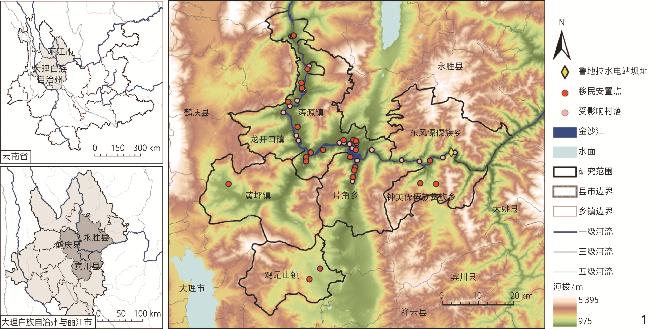
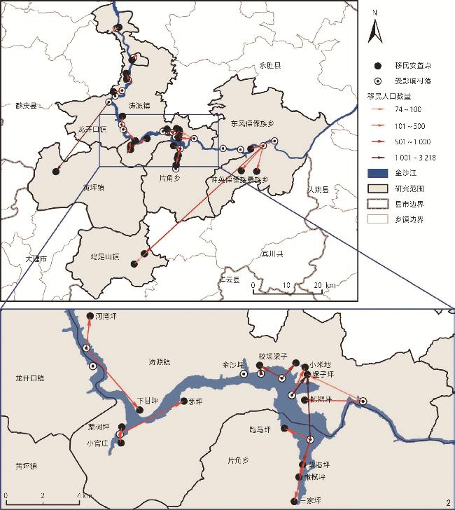
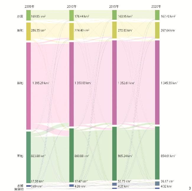
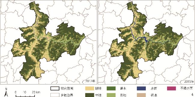
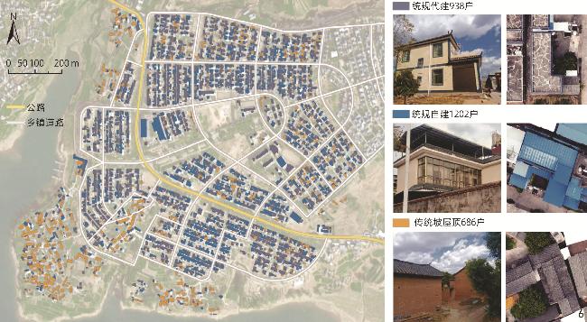
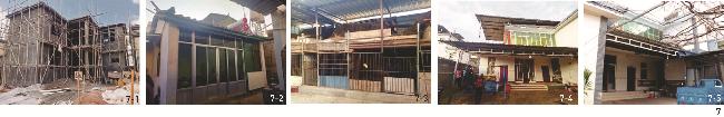
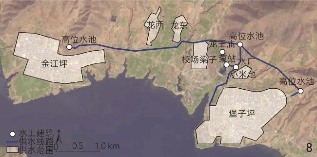
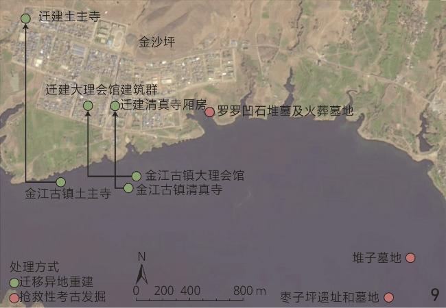
Objective Within human – environment systems, river basins constitute the earliest geographical units of human activity and currently represent the most critical zones of strained human – environment interactions. Facing the prominent and complex contradictions in basin-scale human – environment relationships, the evolution and coupling mechanisms of human – water dynamics have emerged as pivotal research issue. With technological advancements, early humans continuously shaped the earth’s surface through hydraulic facilities such as canals, dams, and embankments, directly intervening in human – water relationships. Since the modern era, large-scale hydraulic and hydropower projects have significantly enhanced the capacity of basin settlements to utilize water resources and hydropower, strengthened resilience against water-related disasters, generated extensive socio-economic and ecological benefits, and altered the productive – ecological coupling relationships of settlements. In this process, the uniqueness of hydropower resettlement lies in the radical restructuring of human – water relationships — transformations that not only reconfigure physical spaces but also fragment basin-rooted local knowledge networks. This research evaluates the compound impacts of hydraulic and hydropower projects on basin-scale human – environment systems, focusing on the adaptive challenges faced by hydropower resettlers under abrupt environmental changes. By constructing a “locality – adaptation” conservation framework, the research reveals how resettlers rebalance local elements through adaptive strategies such as selective preservation, innovative transformation, and memory-driven reconstruction in newly constructed environments. Methods As a typical scenario of abrupt changes in social – ecological systems, the environmental shocks experienced by relocated settlements provide a natural experimental setting for studying human habitat adaptability. This research takes the resettlement communities of the Ludila Hydropower Station along the Jinsha River as the research object, and develops a linkage analysis method that integrates macroscopic land cover evolution with microscopic architectural spatial adjustments. By connecting the drastic environmental effects at the basin level with human behavioral responses at the settlement level, the research visually demonstrates how hydropower projects trigger residential space reconstruction through land resource constraints. At the basin scale, the Patch-level Land Use Simulation Model (PLUS) is employed to analyze land use adaptation changes in the basin during two phases: 2005 –2010 (pre-resettlement period) and 2015 –2020 (post-resettlement period). At the settlement scale, the Mask Region-based Convolutional Neural Network (Mask R-CNN) deep learning model is utilized to identify architectural spatial features, categorizing three typical building types: traditional pitched-roof buildings, uniformly planned flat-roof buildings, and color steel plate-modified structures. Through multi-source data fusion (including remote sensing, demographic statistics, and compensation records) and field investigations, the research quantitatively analyzes the “locality – adaptation” reconstruction process of resettlement communities across the three spatial dimensions of living, production, and cultural spaces. Results 1) Land cover evolution: Water storage of hydropower station inundates 37.12 km2 of land (including 21.61 km² of high-quality cultivated land), resulting in a loss of 43.68% of settlement production space. 2) Adjustment of architectural space: 65.8% of dwellings in the original villages are traditional timber-earth buildings with a tile roof, which adapt to the climate environment of concentrated rainfall and sufficient sunshine in the Jinsha River Basin. 48.7% of the resettlement sites adopt unified flat roof planning, and 51.3% realize functional optimization through self-construction or renovation, with the average renovation area reaching 230.9 m2. 3) Transformation of livelihood system: The annual compensation mechanism only restores 15.79% of the cultivated land allocation before resettlement, and the proportion of compensation income drops from 82.71% in the initial stage of relocation to 33.15% after long-term resettlement, driving the adjustment of crop structure to high value-added cash crops. 4) Cultural space reconstruction: In the context of the disappearance of traditional water transport functions, the three cultural relics reconstructed in different places show a symbolic turn. Among them, Taoyuan Longwang Temple fully retains the original worship function (retention rate is 100%) and forms a functional complement with the new water supply system of Dalongtan Reservoir (replacing the function of 90% of the inundated irrigation area). The local maintenance of cultural space essentially depends on the dual continuation of the functional bearing and symbolic meaning of the relationship between human and water. Conclusion The hydropower settlement forms a systematic response mechanism in the “production – living – culture” dimensions through the adaptive reconstruction of local elements. The living space is translated into climate adaptability by unified planning and construction, and the building renovation rate reaches 73.3%; reservoir inundation results in the loss of 43.68% of high-quality cultivated land, driving the migration of farming space to the middle-high altitude area (the slope demand for forest land development increases by 26.96%), and forming a spatial replacement mechanism of “inundation loss – slope compensation”; the cultural space retains locality through function transformation and symbols of water culture reconstruction. While revealing the rigid constraints of engineering intervention on the natural environment, the research systematically explains the dynamic balance process between the damage of the natural environment and the adjustment of the human system by analyzing the adaptive restructurction of place-based knowledge among resettlement communities achieved by the resettlement communities through spatial practice, and provides a practical paradigm for the sustainable development of the relationship between human and water in the changing environment.
WANG Fang , LI Zhuoqi , XU Haoyi , YAN Jiaqi . “Locality – Adaptation” Research of Hydropower Resettlement Communities in the Jinsha River Basin: A Case Study of Ludila Hydropower Station[J]. Landscape Architecture, 2025 , 32(4) : 12 -20 . DOI: 10.3724/j.fjyl.LA20250143
表1 PLUS 模型驱动因子与数据预处理Tab. 1 PLUS model driving factors and data preprocessing |
| 驱动因子类型 | 驱动因子 | 采样年份 | 数据预处理 |
|---|---|---|---|
| 交通环境 | 到主要公路的距离 | 2009、2018 | 利用ArcGIS距离累积工具提取 |
| 到县城的距离 | |||
| 社会经济环境 | 周边人口密度 | 2010、2019 | 重采样至土地利用数据分辨率 |
| 周边经济活动强度 | 2006、2019 | ||
| 气候环境 | 年降水量 | 2000、2020 | 重采样至土地利用数据分辨率 |
| 年日照时数 | 2000、2020 | ||
| 年平均气温 | 2000、2020 | ||
| 地貌环境 | 海拔 | / | 重采样至土地利用数据分辨率 |
| 坡度 | 根据DEM数据,利用ArcGIS表面分析工具提取,并重采样至土地利用数据分辨率 | ||
| 水环境 | 到金沙江距离 | 2005、2020 | 根据金沙江干流水面数据,利用ArcGIS距离累积工具提取 |
| 植被环境 | 植被净初级生产力 | 2010、2020 | 重采样至土地利用数据分辨率 |
表2 2015—2020年驱动因子对各类土地利用变化贡献度Tab. 2 Contribution of driving factors to various land use changes (2015−2015) |
| 驱动因子类型 | 驱动因子 | 水田 | 旱地 | 林地 | 草地 | 居住 用地 |
|---|---|---|---|---|---|---|
| 交通环境 | 道路距离 | 9.47 | 5.75 | 5.36 | 6.09 | 6.10 |
| 县城距离 | 8.81 | 5.41 | 5.96 | 6.39 | 8.55 | |
| 社会经济环境 | 人口密度 | 9.55 | 9.03 | 11.64 | 9.76 | 17.48 |
| 经济活动 | 10.46 | 22.10 | 10.22 | 13.08 | 7.33 | |
| 气候环境 | 年降水量 | 3.50 | 8.32 | 6.69 | 5.09 | 4.49 |
| 日照时数 | 21.06 | 7.56 | 6.18 | 13.63 | 16.11 | |
| 平均温度 | 2.84 | 5.38 | 5.49 | 5.66 | 3.39 | |
| 地貌环境 | 海拔高度 | 5.45 | 6.40 | 20.18 | 11.04 | 5.32 |
| 地形坡度 | 6.64 | 8.31 | 11.71 | 9.89 | 15.37 | |
| 水环境 | 水体距离 | 15.70 | 14.35 | 9.13 | 12.70 | 9.17 |
| 植被环境 | 植被净初级生产力 | 6.54 | 7.39 | 7.43 | 6.69 | 6.69 |
表3 移民前后驱动因子对各类土地利用变化贡献度差异Tab. 3 Differences in the contribution of driving factors to various land use changes before and after resettlement |
| 驱动因子类型 | 驱动因子 | 水田 | 旱地 | 林地 | 草地 | 居住 用地 |
|---|---|---|---|---|---|---|
| 交通环境 | 道路距离 | -0.56 | -5.31 | -2.04 | -0.81 | 0.14 |
| 县城距离 | -0.12 | -5.24 | -6.32 | -8.21 | -7.59 | |
| 社会经济环境 | 人口密度 | 2.68 | 3.21 | 4.11 | -0.50 | -12.60 |
| 经济活动 | 3.43 | 6.62 | -0.57 | 6.21 | -10.09 | |
| 气候环境 | 年降水量 | -8.85 | -1.65 | -1.02 | -2.66 | 3.52 |
| 日照时数 | 5.45 | 0.01 | -3.80 | 7.13 | 3.76 | |
| 平均温度 | -1.93 | -0.45 | 0.46 | 1.73 | -0.98 | |
| 地貌环境 | 海拔高度 | -4.16 | -1.68 | 4.68 | -1.55 | 2.42 |
| 地形坡度 | 1.13 | 3.24 | 5.97 | 3.50 | 13.12 | |
| 水环境 | 水体距离 | 2.76 | -0.93 | -3.46 | -6.89 | 3.07 |
| 植被环境 | 植被净初级生产力 | 0.15 | 2.17 | 1.99 | 2.04 | 5.22 |
表4 鲁地拉水电站涉及各县征地补偿方式与人均耕地面积对比Tab. 4 Comparison of compensation methods and per capita arable land area in counties affected by the Ludila Hydropower Station |
| 移民所在县 | 征地补偿方式 | 人均逐年补偿耕园地面积/m2 | 人均配置耕园地面积/m2 | 规划水平年(2012年)人均土地收入/元 |
|---|---|---|---|---|
| 永胜县 | 逐年补偿 | 806.67 | 200.00 | 4 113.00 |
| 鹤庆县 | 逐年补偿 | 506.67 | 426.67 | 4 302.00 |
| 宾川县 | 农业安置 | / | 1 133.33 | 2 436.00 |
表5 鲁地拉水电站移民征地补偿与收入增长情况Tab. 5 Compensation for and income growth of resettlers affected by the Ludila Hydropower Station |
| 年份 | 调查移民样本 | 补偿收入/元 | 人均可支配收入/元 | 补偿收入占比/% | 数据来源 |
|---|---|---|---|---|---|
| 注:补偿收入包括每人每年600元的后期扶持直接补助与逐年补偿(宾川县以农业生产方式安置的移民无逐年补偿)。2012—2016年,逐年补偿的标准为每人每月300元,在2015年《云南省人民政府关于进一步做好大中型水电工程移民工作的意见》颁布以后,2017年,逐年补偿标准在审定基础上每人每年增加120元;2018—2022年,按每人每年增加136.8元的标准递增;2023—2027年,按每人每年增加138元的标准递增。 | |||||
| 2011 | 永胜县 | 4 200.00 | 5 078.00 | 82.71 | 张佐[14] |
| 2012 | 永胜县 | 4 200.00 | 5 712.00 | 73.53 | |
| 2013 | 永胜县 | 4 200.00 | 6 319.00 | 66.47 | |
| 2020 | 鹤庆县 | 4 730.40 | 9 358.89 | 50.54 | 杨广芝[15] |
| 2020 | 宾川县 | 600.00 | 18 254.00 | 3.29 | 2022年《金沙江鲁地拉水电站工程竣工验收建设征地移民安置综合监理工作报告》 |
| 2021 | 永胜县 | 4 867.20 | 14 681.00 | 33.15 | |
| 2021 | 鹤庆县 | 4 867.20 | 13 846.00 | 35.15 | |
专题学术主持人 Guest Editor of the Special | ||||
汪芳 WANG Fang | ||||
北京大学建筑与景观学院教授Professor in the College of Architecture and Landscape Architecture, Peking University | ||||
| [1] |
王静, 刘晶晶, 宋子秋, 等. 黄河流域高质量发展的生态保护与国土空间利用策略[J]. 自然资源学报, 2022, 37(11):2930-2945.
WANG J, LIU J J, SONG Z Q, et al. Strategies of Ecosystem Protection and Territory Spatial Utilization for High-Quality Development in the Yellow River Basin[J]. Journal of Natural Resources, 2022, 37(11):2930-2945.
|
| [2] |
傅伯杰, 王帅, 沈彦俊, 等. 黄河流域人地系统耦合机理与优化调控[J]. 中国科学基金, 2021, 35(4):504-509.
FU B J, WANG S, SHEN Y J, et al. Mechanisms of Human-Natural System Coupling and Optimization of the Yellow River Basin[J]. Bulletin of National Natural Science Foundation of China, 2021, 35(4):504-509.
|
| [3] |
胡德胜, 李俊, 夏军, 等. 基于唯物史观的中国水利事业发展阶段探究[J]. 干旱区资源与环境, 2020, 34(9):46-52.
HU D S, LI J, XIA J, et al. On Development Stages of Water Conservancy in China Based on Historical Materialism[J]. Journal of Arid Land Resources and Environment, 2020, 34(9):46-52.
|
| [4] |
HUANG L, LI X, FANG H W, et al. Balancing Social, Economic and Ecological Benefits of Reservoir Operation During the Flood Season: A Case Study of the Three Gorges Project, China[J]. Journal of Hydrology, 2019, 572:422-434.
|
| [5] |
WANG F, XU H Y, HE P W, et al. Adaptive Changes in Traditional Settlements in the Loess Plateau of the Yellow River Basin over 500 Years[J]. River, 2023, 2(2):186-196.
|
| [6] |
汪芳, 李薇, PROMINSKI M. 城镇化和地方性的新冲突、新策略与新探索: 中德双边研讨会会议综述[J]. 地理研究, 2014, 33(11):2205-2214.
WANG F, LI W, PROMINSKI M. The New Conflicts, Strategies and Explorations of Urbanization and Locality: Overview on the Sino-german Symposium[J]. Geographical Research, 2014, 33(11):2205-2214.
|
| [7] |
WANG F, PROMINSKI M. Urbanization and Locality: Strengthening Identity and Sustainability by Site-Specific Planning and Design[M]. Heidelberg: Springer, 2016:24-25.
|
| [8] |
毛华松, 宋尧佳, 陈曦. 社会转型下的单位社区适老性景观更新策略研究: 以重棉厂社区为例[J]. 风景园林, 2019, 26(4):95-99.
MAO H S, SONG Y J, CHEN X. Research on the Strategy of Elderly Friendly Landscape Renewal in Unit Community Under Social Transformation: A Case Study of Chongqing Cotton Mill Community[J]. Landscape Architecture, 2019, 26(4):95-99.
|
| [9] |
NILSSON C. Flood Warnings[J]. Nature, 2005, 435:1031
|
| [10] |
HE K, GKIOXARI G, DOLLÁR P, et al. Mask R-CNN[J]. IEEE Transactions on Pattern Analysis and Machine Intelligence, 2020, 42(2):386-397.
|
| [11] |
朱盼盼, 李帅朋, 张立强, 等. 基于多任务学习的高分辨率遥感影像建筑提取[J]. 地球信息科学学报, 2021, 23(3):514-523.
ZHU P P, LI S P, ZHANG L Q, et al. Multitask Learning-Based Building Extraction from High-Resolution Remote Sensing Images[J]. Journal of Geo-Information Science, 2021, 23(3):514-523.
|
| [12] |
孙俊娜. 易地扶贫搬迁安置方式对搬迁农户社会融入的影响研究[J]. 中国农业资源与区划, 2022, 43(8):164-171.
SUN J N. Study on the Impact of Resettlement Ways on the Social Integration of Relocated Farmers[J]. Chinese Journal of Agricultural Resources and Regional Planning, 2022, 43(8):164-171.
|
| [13] |
YANG J, HUANG X. The 30 m Annual Land Cover Dataset and Its Dynamics in China from 1990 to 2019[J]. Earth System Science Data, 2021, 13(8):3907-3925.
|
| [14] |
张佐. 云南水电开发失地农民收入增长机制研究[D]. 北京: 北京林业大学 2014.
ZHANG Z. Study on the Reservoir Immigrant Resettlement Areas Income Growth Mechanism in Yunnan Province[D]. Beijing: Beijing Forestry University 2014.
|
| [15] |
杨广芝. 基于层次分析法的鲁地拉水电站鹤庆库区移民政策实施效果评估研究[D]. 昆明: 云南财经大学, 2022.
YANG G Z. Research on Implementation Effect of Heqing Reservoir District Immigration Policy Based on Hierarchical[D]. Kunming: Yunnan University of Finance and Economics, 2022.
|
| [16] |
中国永胜. 云南边屯文化博物馆, 永胜边屯文化研究院.边屯探源[M]. 昆明: 云南人民出版社, 2014.18-25.
China Yongsheng. Yunnan Frontier Garrison Culture Museum, Yongsheng Frontier Garrison Culture Research Institute. Exploring the Origins of the Frontier Garrison[M]. Kunming: Yunnan People’s Publishing House, 2014.18-25.
|
| [17] |
刘必苏, 朱庭珍. 永北直隶厅志[M]. 昆明: 云南人民出版社, 2018.32-34.
LIU B S, ZHU T Z. Yongbei Directly Subordinate Department Annals[M]. Kunming: Yunnan People’s Publishing House, 2018.32-34.
|
| [18] |
云南省永胜县志编纂委员会. 永胜县志[M]. 昆明: 云南人民出版社, 1989.57.
Yongsheng County Annals Compilation Committee of Yunnan Province. Yongsheng County Annals[M]. Kunming: Yunnan People’s Publishing House, 1989.57.
|
/
| 〈 |
|
〉 |