
Generation of Spatial Structure of Urban Parks Based on Spatial Analysis of Agent-Based Models
|
KONG Huizi is a master student in the School of Landscape Architecture, Beijing Forestry University. Her research focuses on landscape planning and design |
|
LIU Tianming is a master student in Bartlett Faculty of the Built Environment, University College London. His research focuses on landscape planning and design, spatial analysis, and spatial measurement |
|
LIAO Jiajie is a master student in the School of Landscape Architecture, Beijing Forestry University. Her research focuses on landscape planning and design |
|
CUI Liu, Ph.D., is an associate professor in the School of Landscape Architecture, Beijing Forestry University. Her research focuses on landscape planning and design |
Received date: 2024-08-03
Revised date: 2025-01-15
Online published: 2025-12-12
Copyright
This research aims to leverage the advances of computer algorithms to provide scientific analytical methods for spatial simulation and offer a more objective approach to reflect the natural operational laws of interdependencies between elements in the real physical world for landscape design. Multi-source data characterized by high-density distribution can reflect urban features and spatial patterns at a macro scale. This research employs agent-based models (ABM) to simulate spatial information and explore the spatial function distribution of planned sites under urban spatial function penetration, thereby guiding the structural morphology of scheduled sites.
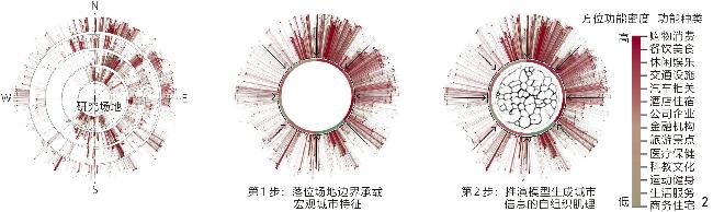
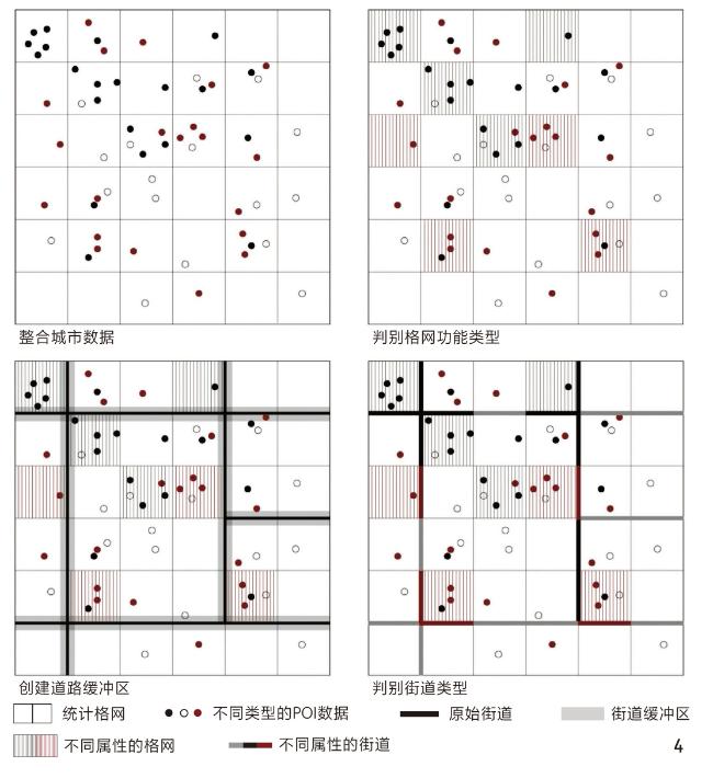
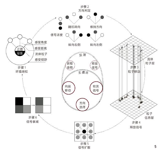
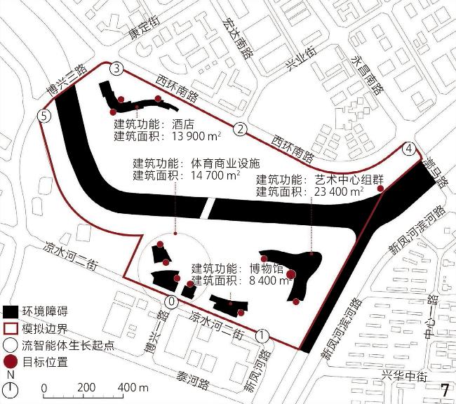
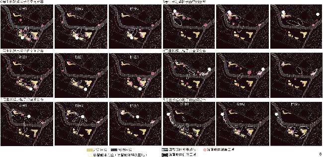
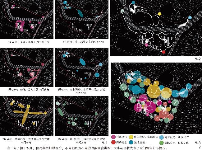
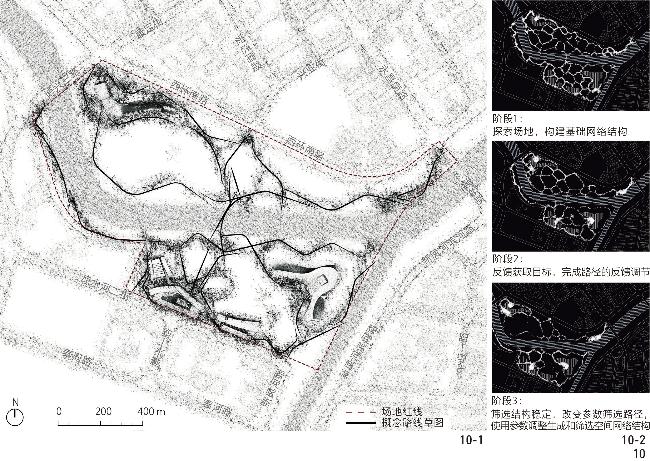
This research adopts a spatial network analysis design method using slime mold intelligence based on mapping point of interest (POI) data. Firstly, POI data and urban basic information data within the Yizhuang New City area of Beijing are obtained through the application programming interface (API) of Gaode Map to construct the spatial network foundation of the research area. The POI data are grouped into eight types: data on residential areas, hotel accommodations, road traffic, education and culture, medical care, business offices, commercial services, and green space tourism. Secondly, a slime mold agent model is constructed using the NetLogo platform, with the behavioral rules of cytoplasm agents, nuclei agents, and patch agents being defined to simulate the growth behavior of slime molds. By adjusting model parameters, the foraging paths of slime molds in the designed site are simulated, and their spatial function distribution is analyzed. The simulation environment is based on multi-source data analysis and involves setting particle growth points, food locations, and environmental obstacles. Six particle growth points represent the main entry points to the designed site, while food locations are placed at significant building entrances and preserved landscape nodes. The environmental obstacles consist of planned buildings and river channels. Finally, the model incorporates these elements (growth points, food locations, obstacles) to analyze and optimize spatial functions.
The research results indicate that the design method for spatial network analysis using slime mold intelligence based on POI data mapping is highly feasible in the landscape design of small and medium-sized sites. The ABM simulation of slime mold growth behavior can effectively reflect the infiltration of surrounding functional information into the designed site, forming a spatial function zoning map with path texture. The path simulation results provide valuable insights into path connections, functional layouts, and crowd-gathering patterns, closely aligning with actual site usage requirements. Specifically, the simulation demonstrates how different functional areas and their respective uses can be distributed across the designed site, allowing for a more informed and responsive design process. Additionally, the simulation results show that the slime mold agent model can rapidly generate foraging networks in complex environments due to its efficient organization and structural resilience, as well as optimize path selection according to behavioral objectives.
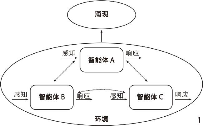
ABM analysis, supported by advanced algorithms, considers the basic spatial information of the site and simulates individual behavior patterns using distributed computation rules, thereby providing a new paradigm for landscape design thinking. Integrating multi-source data allows ABM to simulate urban spaces' self-organizing behavior and enhance the matching between designed and actual site conditions. This method provides a scientific analytical approach for landscape design from macro to micro scales, helping form spatial structure optimization schemes based on bottom-up design concepts. The combined application of ABM and multi-source data will contribute to the paradigm shift in urban spatial planning, offering new theoretical and practical support for the design of urban park systems. Applying slime mold intelligence through ABM can provide a robust framework for analyzing and designing urban spaces. This approach allows for the simulation of complex spatial interactions and the emergence of spatial patterns that reflect the dynamicity of urban environments, which may, by leveraging multi-source data, offer a comprehensive tool for landscape architects to design functional, responsive, and sustainable urban spaces. The findings underscore the potential of ABM to transform urban landscape design by providing a detailed and data-driven understanding of spatial dynamics and functional distribution, thus helping make more informed and effective design decisions. This expanded approach underscores the feasibility of using slime mold intelligence in landscape design, demonstrating its potential to reshape traditional design methodologies. Integrating POI data with ABM can provide a high level of accuracy in reflecting real-world conditions and enhance the adaptability and sustainability of landscape design. As cities continue to evolve and expand, the methodologies explored in this research will become increasingly relevant, providing landscape architects with the tools necessary to create urban environments that are both functional and harmonious with their natural and social contexts. The research paves the way for future research and application in urban planning, emphasizing the importance of data-driven, adaptive design processes in creating resilient and livable urban spaces.
KONG Huizi , LIU Tianming , LIAO Jiajie , CUI Liu . Generation of Spatial Structure of Urban Parks Based on Spatial Analysis of Agent-Based Models[J]. Landscape Architecture, 2025 , 32(3) : 73 -81 . DOI: 10.3724/j.fjyl.202408030430
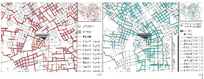
图6 场地周边单一(6-1)、混合(6-2)功能主导型街道分布Fig. 6 Distribution of single-function dominant streets (6-1) in the vicinity of the designed site and mixed-function dominant streets (6-2) in the vicinity of the designed site |
表2 设计场地边界信息Table 2 Boundary information of the designed site |
| 代表道路 | 功能类型 | 边界类型 | 包含的核智能体点位编号 |
| 博兴三路 | 单一功能主导型 | 绿地观光 | 3、5 |
| 凉水河二街西路段 | 单一功能主导型 | 科教文化 | 5 |
| 凉水河二街东路段 | 混合功能型 | 商务办公、科教文化 | 0、1 |
| 西环南路西路段 | 混合功能型 | 商务办公、生活居住 | 2、3 |
| 西环南路东路段 | 混合功能型 | 商务办公、科教文化 | 2、4 |
| 漷马路 | 混合功能型 | 商业服务、生活居住 | 4 |
文中图表均由作者绘制,其中
| [1] |
陶海燕, 黎夏, 陈晓翔. 基于多智能体的居住空间格局演变的真实场景模拟[J]. 地理学报, 2009, 64(6): 665-676.
TAO H Y, LI X, CHEN X X. Simulation for Evolvement of Residential Spatial Patterns in Real Scene Based on Multi-agent[J]. Acta Geographica Sinica, 2009, 64(6): 665-676.
|
| [2] |
龙瀛, 毛其智, 杨东峰, 等. 城市形态、交通能耗和环境影响集成的多智能体模型[J]. 地理学报, 2011, 66(8): 1033-1044.
LONG Y, MAO Q Z, YANG D F, et al. A Multi-agent Model for Urban Form, Transportation Energy Consumption and Environmental Impact Integrated Simulation[J]. Acta Geographica Sinica, 2011, 66(8): 1033-1044.
|
| [3] |
MAS E, SUPPASRI A, IMAMURA F, et al. Agent-Based Simulation of the 2011 Great East Japan Earthquake/Tsunami Evacuation: An Integrated Model of Tsunami Inundation and Evacuation[J]. Journal of Natural Disaster Science, 2012, 34(1): 41-57.
|
| [4] |
LIU J, ZHANG M, NIKITA N. Agent-Based Design Research to Explore the Effectiveness of Bottom-Up Organizational Design in Shaping Sustainable Vernacular Landscapes: A Case in Hailar, China[J]. Landscape and Urban Planning, 2021, 205: 103961.
|
| [5] |
曲志华, 蔡正春. 基于多智能体技术的景观规划模型建构[J]. 建筑与文化, 2015(2): 124-125.
QU Z H, CAI Z C. The Landscape Planning Model Based on Multi-agent Technology Construction[J]. Architecture & Culture, 2015(2): 124-125.
|
| [6] |
LIU.多智能体原理与技术[M].靳小龙, 译.北京: 清华大学出版社, 2003: 1-2.
LIU J M. Autonomous Agents and Multi-agent Systems[M]. JIN X L, translated. Beijing: Tsinghua University Press, 2003: 1-2.
|
| [7] |
GRIMM V, RAILSBACK S F. Individual-based Modeling and Ecology[M]. Princeton: Princeton University Press, 2005.
|
| [8] |
GIMBLETT HR, SKOV-PETERSON H. Monitoring, Simulation, and Management of Visitor Landscapes[M]. Arizona: University of Arizona Press, 2008: 411.
|
| [9] |
申海.集群智能及其应用[M].北京: 科学出版社, 2019.
SHEN H. Swarm Intelligence and Its Application[M]. Beijing: Science Press, 2019.
|
| [10] |
曲志华.景观空间复杂系统模型: 基于智能体技术的游人活动模型研究[D].南京: 东南大学, 2014: 19.
QU Z H. Landscape Spatial Models of Complex Systems-Tourist Activities Based on Agent Technology Research Model[D]. Nanjing: Southeast University, 2014: 19.
|
| [11] |
霍兰.涌现: 从混沌到有序[M].陈禹, 译.上海: 上海科学技术出版社, 2006: 15.
HOLLAND J. Emergence: From Chaos to Order[M]. CHEN Y, translated. Shanghai: Shanghai Scientific & Technical Publishers, 2006: 15.
|
| [12] |
里奇, 斯努克斯.集群智能: 多智能体系统建筑[M].宋刚, 译.上海: 同济大学出版社, 2017: 81.
LEACH N, SNOOKS R. Swarm Intelligence: Architectures of Multi-agent Systems[M]. SONG G, translated. Shanghai: Tongji University Press, 2017: 81.
|
| [13] |
北京市规划和自然资源委员会.亦庄新城规划(国土空间规划)(2017—2035年)[EB/OL].(2020-02-14)[2024-08-03].https://ghzrzyw.beijing.gov.cn/zhengwuxinxi/ghcg/fqgh/202002/t20200213_1630030.html.
Beijing Municipal Commission of Planning and Natural Resources. Yizhuang New City Plan (Territorial Space Plan) (2017−2035)[EB/OL]. (2020-02-14)[2024-08-03]. https://ghzrzyw.beijing.gov.cn/zhengwuxinxi/ghcg/fqgh/202002/t20200213_1630030.html.
|
| [14] |
骆少华, 刘扬, 高思岩, 等. 基于空间格网的城市功能区定量识别[J]. 测绘通报, 2020(S1): 214-217.
LUO S H, LIU Y, GAO S Y, et al. Quantitative Identification of Urban Functional Areas Based on Spatial Grid[J]. Bulletin of Surveying and Mapping, 2020(S1): 214-217.
|
| [15] |
TERO A, KOBAYASHI R, NAKAGAKI T. A Mathematical Model for Adaptive Transport Network in Path Finding by True Slime Mold[J]. Journal of Theoretical Biology, 2007, 244(4): 553-564.
|
| [16] |
TERO A, TAKAGI S, SAIGUSA T, et al. Rules for Biologically Inspired Adaptive Network Design[J]. Science, 2010, 327(5964): 439-442.
|
| [17] |
JONES J. Characteristics of Pattern Formation and Evolution in Approximations of Physarum Transport Networks[J]. Artificial Life, 2010, 16(2): 127-153.
|
| [18] |
LI S, CHEN H, WANG M, et al. Slime Mould Algorithm: A New Method for Stochastic Optimization[J]. Future Generation Computer Systems, 2020, 111: 300-323.
|
| [19] |
杨俊宴, 邵典, 汪鹏, 等. 集成·拓扑·转译: 一种基于知识图谱的城市形态深度解析方法[J]. 城市规划, 2023, 47(6): 57-67.
YANG J Y, SHAO D, WANG P, et al. Integration, Topology, and Translation: An In-Depth Analysis Method of Urban Form Based on Knowledge Map[J]. City Planning Review, 2023, 47(6): 57-67.
|
/
| 〈 |
|
〉 |
