
Character Assessment and Management of Agricultural Landscape in the Alluvial Zone of the Pearl River Delta
|
YAO Yunjiao is a Ph.D. candidate in the School of Architecture, South China University of Technology. Her research focuses on landscape change and landscape character |
|
ZHOU Jianyun, Master, is a professor in the School of Architecture, South China University of Technology, and a member of the State Key Laboratory of Subtropical Building Science. His research focuses on urban planning and design, and urban planning regulations |
Received date: 2023-07-29
Revised date: 2023-11-28
Online published: 2025-12-11
Copyright
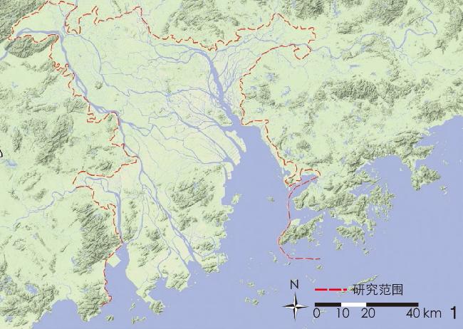
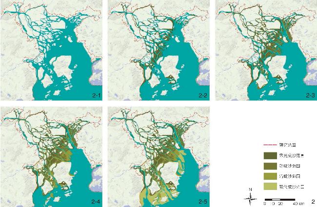
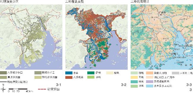
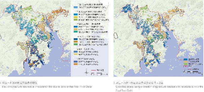
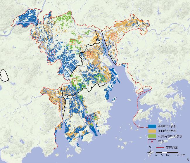
[Objective] The agricultural landscape in the alluvial plain of the Pearl River Delta is spread over the plains formed by the alluvial deposits of many rivers in the shallow bay. The highly developed river network and water system, while providing convenience for agricultural production, also place higher demands on the rational development of soil and water resources. In history, local residents mainly adopted the method of embankment construction and reclamation to compete with the rivers for fields, and the interaction between humans and water lasted for more than a thousand years, giving birth to an agricultural landscape with unique landscape characters. Agricultural practices have led to profound landscape changes, with corresponding landscape characters being the result of the interaction between natural and human factors. However, in the practice of rapid urbanization and agricultural intensification, homogenized and standardized construction is rapidly expanding, and modern urban landscape elements are superimposed on traditional agricultural landscape, making the landscape highly fragmented with their characters weakened or deviating from the original landscape characters, while resulting in a continuous loss of the diversity and continuity of the agricultural landscape. Character assessment is an important basis for the management and conservation of the agricultural landscape in the context of rapid urbanization. [Methods] This research adopts the landscape character assessment (LCA) method to categorize the characters of agricultural landscape in the alluvial zone of the Pearl River Delta, and selects geographic evolution, river basin, and land cover as character superimposition elements. To better represent the interaction between natural processes and human activities or the degree of interaction between the two in the past, and to understand the historical influence if such interaction on landscape formation and characterization, the research superimposes the process of regional geographic evolution as one of the criteria for delineating landscape character areas. Specifically, the geographical evolution of the research area is divided into five stages: the period of the Han and Tang dynasties, the period of the Song and Yuan dynasties, the period of the Ming Dynasty, the period of the Qing Dynasty, and the modern period. [Results] Through GIS analysis and manual-assisted correction, the research delineates 6 primary and 14 secondary agricultural landscape character types, and draws a regional-scale agricultural landscape character map. Meanwhile, the research carries out attribute summarization and typological classification of character types, and summarizes three agricultural landscape types, namely dike-pond landscape, field landscape, and flower and seedling landscape, which are also illustrated and characterized by typical samples (5 km × 5 km). The six primary landscape character types and their respective characteristics are described as follows. 1) Agricultural landscape in the northwestern part of the North and West River Delta: basal ponds in this area vary in size and scale. 2) Agricultural landscape in the north-central part of the North and West River Delta: The long history of agriculture enables this area to preserve the traditional pattern of agricultural landscape, with the traditional flower and tree areas combining agricultural tourism with production and operation. 3) Agricultural landscape in the central part of the North and West River Delta: As the main cultivation area in the alluvial plain of the Pearl River Delta, this area boasts highly developed agriculture, and the agricultural landscape here is characterized by a homogeneous rectangular grid; besides, a large-scale and intensive greenhouse agricultural landscape has been formed in this area. 4) Agricultural landscape in the southern part of the North and West River Delta: Most of the agricultural lands in this area are formed by swidden cultivation, and the agricultural landscape here presents regularized and standardized geometric segmentation, which is significantly different from other areas. 5) Agricultural landscape in the Tam River Delta: This area is featured by a large-scale uniform fruit tree cultivation landscape. 6) Agricultural landscape in the Dongjiang River Delta: This area has excellent soil and water resources and is dominated by fruit and vegetable cultivation. [Conclusion] Dyke enclosure and the water system structure and land boundaries delineated by dyke enclosure are identified as key character elements of the agricultural landscape in the research area, and also a key part of the management strategies for agricultural landscape. This research suggests different management strategies for different types of agricultural landscapes. The dike-pond agricultural landscape is the most widespread and representative landscape type in the research area. It is most affected by urban development, and with the continuous “point – line – plane” expansion of local settlement patterns, the dike-pond texture is gradually fragmented and regularized. The management of such landscape should focus on conservation at the macro, meso, and micro levels. The field landscape takes plains and coastal mudflats as the main source of land, and is closely linked to land development and production entity. The management of such landscape should focus on regeneration, a combination of recreational activities such as agricultural tourism and picking with industrial and institutional renewal, and synergistic development with the city, to create a new type of urban field landscape. The flower and seedling landscape is a new type of agricultural landscape that combines production, sales, recreation and tourism, concentrated in traditional flower and tree areas. The management of such a landscape should focus on the maintenance of the current status. This type of agricultural landscape is minimally affected by modern urban landscape elements, with roads and settlements forming part of the corresponding transport and sales landscape.
Yunjiao YAO , Jianyun ZHOU . Character Assessment and Management of Agricultural Landscape in the Alluvial Zone of the Pearl River Delta[J]. Landscape Architecture, 2024 , 31(1) : 56 -63 . DOI: 10.3724/j.fjyl.202307290343
| 分区 | 成陆时期 | 范围 | 地形地貌特征 | 地下水性质 | |
| 西北江 三角洲 | 西北部 | 4 000年以前 | 思贤滘—三水以北 | 多为积水洼地 | 多为淡水型 |
| 中北部 | 新石器及秦汉时期, 部分为唐代 | 思贤滘以南,黄埔—石楼—上街市—荷塘—江门一线以西 | 平原与丘陵台地 | 微咸水型 | |
| 中部 | 宋代以后 | 黄埔—石楼—上街市—荷塘—江门一线以东,五桂山以北 | 地势十分平坦;汊道发育程度较高,是珠江三角洲最典型的网河区 | 咸水型,是地下肥水的主要分布区 | |
| 南部 | 明清后 | 沙溪—大鳌—睦州一线以南 | 处于五桂山、黄杨山等低山丘陵之间 | 地下水矿化度高,是咸酸田的分布区 | |
| 潭江三角洲 | 唐代后 | 以江门河为东界 | 地势平坦 | 地下肥水的分布区 | |
| 东江三角洲 | 唐代后 | 以狮子洋为西界 | 地势平坦 | 淡水型及微咸水型 | |
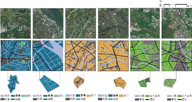
表2 珠江三角洲冲积区农业景观样本图解Tab. 2 Illustration of sampled agricultural landscape in the alluvial zone of the Pearl River Delta |
| 类型 | 样本 | 区位 | 围垦时期 | 生产主体 | 卫星图及要素图解 | 特征描述 | 关键要素 | 管理策略 |
| 基塘农业景观 | A | 西北江三角洲中北部区 | 唐代 | 家庭或村委 | ① | 自然有机的水系结构;有机形态的基塘划分;聚落在山岗等高地呈块状分布 | 堤围划分的水系结构;基塘边界及形态;堤围窦闸构成的水利系统 | 保护 |
| B | 西北江三角洲南部区 | 现代 | 国营农场或产业园区 | ② | 直线交错的水系结构;规则网格型的基塘划分;聚落在河道或道路两侧呈线状分布 | |||
| 田园农业景观 | C | 东江三角洲 | 宋元 | 家庭或村委 | ③ | 围田;形态较有机;聚落在道路交叉处呈块状分布 | 堤围划分的土地形态;围垦时期及土壤类型;堤围窦闸构成的排灌系统 | 更新 |
| D | 西北江三角洲中部区 | 明清 | 国营农场或产业园区 | ④ | 沙田;形态较规则;聚落在河道或道路两侧呈线状分布 | |||
| 花卉苗木农业景观 | E | 西北江三角洲中北部区 | 秦汉 | 苗木公司 | ⑤ | 由水系及道路划分边界;形态较规则;聚落在道路交叉处呈片状分布 | 标准化苗木基地、苗圃大棚;以人工开挖水渠为主 | 维持 |
| F | 西北江三角洲中部区 | 宋元 | 苗木公司 | ⑥ | 由水系及道路划分边界;规则网格结构;聚落在道路交叉处呈片状分布 |
① 此数据来源于广东省水利厅关于“珠江三角洲水系”的描述。
| [1] |
TAROLLI P, STRAFFELINI E. Agriculture in Hilly and Mountainous Landscapes: Threats, Monitoring and Sustainable Management[J]. Geography and Sustainability, 2020, 1(1): 70-76.
|
| [2] |
姚韵娇, 周剑云. 英格兰乡村品质统计概述: 监测景观变化的系统[J]. 广东园林, 2021, 43(5): 20-25.
YAO Y J, ZHOU J Y. Overview of Countryside Quality Counts: A System for Monitoring Landscape Change[J]. Guangdong Landscape Architecture, 2021, 43(5): 20-25.
|
| [3] |
WASCHER D M. European Landscape Character Areas: Typologies, Cartography and Indicators for the Assessment of Sustainable Landscapes[R]. Wageningen: European Landscape Character Assessment Initiative (ELCAI), 2005.
|
| [4] |
SWANWICK C. Landscape Character Assessment Guidance for England and Scotland[R]. Sheffield: The Countryside Agency, Scottish Natural Heritage, 2002.
|
| [5] |
司万维克, 高枫. 英国景观特征评估[J]. 世界建筑, 2006(7): 23-27.
SWANWICK C, GAO F. Landscape Character Assessment in Britain[J]. World Architecture, 2006(7): 23-27.
|
| [6] |
CHRISTINE T. An Approach to Landscape Character Assessment[R]. Sheffield: Natural England, 2014.
|
| [7] |
HAINES-YOUNG R, MARTIN J, TANTRAM D, et al. Countryside Quality Counts Tracking Change in the English Countryside[R]. Nottingham: University of Nottingham and the Countryside Agency, 2004.
|
| [8] |
陶彦利, 奚雪松, 祝明建. 欧洲景观特征评估(LCA)方法及其对中国的启示[J]. 中国园林, 2018, 34(8): 107-112.
TAO Y L, XI X S, ZHU M J. The Method of European Landscape Character Assessment and Its Reference Value to China[J]. Chinese Landscape Architecture, 2018, 34(8): 107-112.
|
| [9] |
SANDER M. European Landscape Mapping[R]. Wageningen: Wageningen University & Research, 2007.
|
| [10] |
EETVELDE V V, ANTROP M. Indicators for Assessing Changing Landscape Character of Cultural Landscapes in Flanders (Belgium)[J]. Land Use Policy, 2009, 26(4): 901-910.
|
| [11] |
ALFREY J. Contexts for Historic Landscape Characterisation in Wales[J]. Landscapes, 2007(2): 84-91.
|
| [12] |
汪伦, 张斌. 景观特征评估: LCA体系与HLC体系比较研究与启示[J]. 风景园林, 2018, 25(5): 87-92.
WANG L, ZHANG B. Comparative Study of Landscape Character Assessment and Historic Landscape Characterisation and Its Inspiration to China[J]. Landscape Architecture, 2018, 25(5): 87-92.
|
| [13] |
谢雨婷, 诺尔夫. 长三角大都市区文化景观特征评估[J]. 中国园林, 2020, 36(12): 73-78.
XIE Y T, NOLF C. Cultural Landscape Characterization in the Metropolitan Areas of the Yangtze River Delta[J]. Chinese Landscape Architecture, 2020, 36(12): 73-78.
|
| [14] |
姚洁.杭州市富春江沿岸乡村景观特征研究[D].杭州: 浙江农林大学, 2021.
YAO J. Study on Landscape Characteristics of Countryside along Fuchun River in HangZhou[D]. Hangzhou: Zhejiang A&F University, 2021.
|
| [15] |
胡泽浩, 方小山. 基于LCA的珠三角乡村景观保护与发展研究[J]. 南方建筑, 2021(4): 82-89.
HU Z H, FANG X S. Rural Landscape Conservation and Development in Pearl River Delta Based on Landscape Character Assessment[J]. South Architecture, 2021(4): 82-89.
|
| [16] |
广州地理研究所.珠江三角洲形成发育演变[M].广州: 科学普及出版社广州分社, 1982.
Guangzhou Geographic Institute. Formation and Development of the Pearl River Delta[M]. Guangzhou: Science Popularization Press Guangzhou Branch, 1982.
|
| [17] |
《中国河湖大典》编纂委员会.中国河湖大典珠江卷[M].北京: 中国水利水电出版社, 2013: 277-279.
Editorial Committee of Encyclopedia of Rivers and Lakes in China. Encyclopedia of Rivers and Lakes in China: Section of Zhujiang River Basin[M]. Beijing: China Water & Power Press, 2013: 277-279.
|
| [18] |
许自力. 珠江三角洲流域水系景观特征及结构性问题[J]. 中国园林, 2009, 25(4): 54-58.
XU Z L. The River System Landscape and Structural Problems of the Pearl River Delta[J]. Chinese Landscape Architecture, 2009, 25(4): 54-58.
|
| [19] |
《广东省志》编纂委员会.广东省志·资源·环境卷[M].北京: 方志出版社, 2014: 1-40.
Editorial Committee of Guangdong Provincial Records. Guangdong Provincial Records: Resources-Environment Volume[M]. Beijing: Publishing House of Local Records, 2014.
|
| [20] |
《广东省地方史志》编纂委员会.广东省志·地理志[M].广州: 广东人民出版社, 2014: 83-89.
Editorial Committee of Guangdong Provincial Local Historical Records. Guangdong Province: Geography[M]. Guangzhou: Guangdong People’s Publishing House, 2014: 83-89.
|
| [21] |
《南海市地方志》编纂委员会.南海县志[M].北京: 中华书局, 2000.
Editorial Committee of Nanhai City Local Records. Records of Nanhai County[M]. Beijing: Zhonghua Book Company, 2000.
|
| [22] |
刘明光.中国自然地理图集[M].北京: 中国地图出版社, 2010: 167-168.
LIU M G. Atlas of Physical Geography of China[M]. Beijing: Sinomap Press, 2010: 167-168.
|
| [23] |
屈大均.广东新语[M].北京: 中华书局, 2010: 56.
QU D J. New Encyclopedia of Guangdong[M]. Beijing: Zhonghua Book Company, 2010: 56.
|
| [24] |
傅同钦. 明清时期的广东沙田[J]. 学术研究, 1981(3): 42-45.
FU T Q. Guangdong Sandy Land During the Ming and Qing Dynasties[J]. Academic Research, 1981(3): 42-45.
|
| [25] |
赵绍祺, 杨智维.珠江三角洲堤围水利与农业发展史[M].广州: 广东人民出版社, 2011: 81-272.
ZHAO S Q, YANG Z W. History of Dike and Agricultural Development in the Pearl River Delta[M]. Guangzhou: Guangdong People’s Press, 2011: 81-272.
|
| [26] |
谭其骧.中国历史地图集[M].北京: 中国地图出版社, 1996.
TAN Q X. The Historical Altas of China[M]. Beijing: Sinomap Press Publishing House, 1996.
|
| [27] |
吴建新. 宋元珠江三角洲的农业社会变迁[J]. 古今农业, 2016, 107(1): 31-45.
WU J X. Agricultural Social Changes on Pearl River Delta in Song and Yuan Dynasties[J]. Ancient and Modern Agriculture, 2016, 107(1): 31-45.
|
| [28] |
叶显恩, 周兆晴. 宋代以降珠江三角洲冲积平原的开发[J]. 珠江经济, 2007, 190(6): 74-80.
YE X E, ZHOU Z Q. Development of Alluvial Plain in Pearl River Delta Since Song Dynasty[J]. South China Review, 2007, 190(6): 74-80.
|
| [29] |
刘志伟. 宗族与沙田开发: 番禺沙湾何族的个案研究[J]. 中国农史, 1992(4): 34-41.
LIU Z W. Clans and Shatin Development: A Case Study of the Ho Clan in Shawan, Panyu[J]. Agricultural History of China, 1992(4): 34-41.
|
| [30] |
吴建新. 明代珠江三角洲的农业与环境: 以环境压力下的技术选择为中心[J]. 华南农业大学学报(社会科学版), 2006(4): 127-134.
WU J X. Agriculture and Environment in the Pearl River Delta in the Ming Dynasty[J]. Journal of South China Agricultural University (Social Science Edition), 2006(4): 127-134.
|
| [31] |
吴建新. 清代垦殖政策的两难选择: 以珠江三角洲沙田的放垦与禁垦为例[J]. 古今农业, 2010, 83(1): 89-97.
WU J X. On the Dilemma of Cultivation Policy in Qing Dynasty: Cultivation Forbidden and Lift in Zhujiang River Delta as a Case[J]. Ancient and Modern Agriculture, 2010, 83(1): 89-97.
|
| [32] |
《肇庆市鼎湖区地方志》编纂委员会.肇庆市鼎湖区志[M].北京: 中华书局, 2012: 260-271.
Editorial Committee of Zhaoqing City Dinghu District Local Records. Zhaoqing Dinghu District Records[M]. Beijing: Zhonghua Book Company, 2012: 260-271.
|
| [33] |
《四会县地方志》编纂委员会.四会县志[M].广州: 广东人民出版社, 1996: 290.
Editorial Committee of Sihui County Local Records. Sihui County Records[M]. Guangzhou: Guangdong People’s Press, 1996: 290.
|
| [34] |
马符录.西樵山志[M].桂林: 广西师范大学出版社, 2012: 102.
MA F L. Records of Xiqiao Mountain[M]. Guilin: Guangxi Normal University Press, 2012: 102.
|
| [35] |
《广东省佛山市南海区地方志》编纂委员会.南海市志[M].广州: 广东人民出版社, 2009: 402.
Editorial Committee of Guangdong Province Foshan City Nanhai District Local Records. Nanhai Records[M]. Guangzhou: Guangdong People’s Press, 2009: 402.
|
| [36] |
广州市南沙区档案局.南沙大全[M].广州: 岭南美术出版社, 2011: 57.
Guangzhou Nansha District Archives Bureau. Nansha Book[M]. Guangzhou: Lingnan Fine Arts Publishing House, 2011: 57.
|
| [37] |
《中山市志》编纂委员会.中山市志[M].广州: 广东人民出版社, 2012: 455.
Editorial Committee of Zhongshan City Records. Zhongshan City Records[M]. Guangzhou: Guangdong People’s Press, 2012: 455.
|
| [38] |
《斗门围垦志》编纂委员会.斗门围垦志[M].郑州: 中州古籍出版社, 2020.
Editorial Committee of Doumen Polder Records. Doumen Polder Records[M]. Zhengzhou: Zhongzhou Ancient Books Publishing House, 2020.
|
| [39] |
《新会县地方志》编纂委员会.新会县志[M].广州: 广东人民出版社, 1995: 296-300.
Editorial Committee of Xinhui County Local Records. Xinhui County Records[M]. Guangzhou: Guangdong People’s Press, 1995: 296-300.
|
| [40] |
Consultants Land-Use. European Landscape Convention Guidance[R]. London: Natural England, 2009.
|
| [41] |
佛山地区革命委员会《珠江三角洲农业志》编写组.珠江三角洲农业志[M].广州: 广东人民出版社, 1976: 3-4.
Editorial Group of Agricultural Records of the Pearl River Delta, Foshan Revolutionary Committee. Agricultural Records of the Pearl River Delta[M]. Guangzhou: Guangdong People’s Press, 1976: 3-4.
|
| [42] |
田梦晓. 当代基塘景观的空中观察[J]. 景观设计学, 2019, 7(4): 130-138.
TIAN M X. Seeing from Above: Observation of Contemporary Dike-Pond Landscape[J]. Landscape Architecture Frontiers, 2019, 7(4): 130-138.
|
/
| 〈 |
|
〉 |