
Resilient Response in Coastal Urban Planning Based on Ecosystem-Based Disaster Risk Reduction: A Case Study of Compound Rainstorm and Heatwave Disaster Risks in Shanghai
|
BO Mingyang is a Ph.D. candidate in the College of Architecture and Urban Planning (CAUP), Tongji University. His research focuses on ecosystem-based disaster risk reduction |
|
DAI Daixin, Ph.D., is an assistant professor and doctoral supervisor in the College of Architecture and Urban Planning (CAUP), Tongji University, and director of Landscape Space Experiment Center of the Joint International Research Laboratory of Eco-urban Design, Ministry of Education. His research focuses on landscape planning and design and theory of landscape architecture |
|
LIAO Wandi is a undergraduate student in the College of Architecture and Urban Planning (CAUP), Tongji University. Her research focuses on ecosystem-based disaster risk reduction |
Received date: 2025-02-28
Revised date: 2025-08-12
Online published: 2025-12-10
Copyright
[Objective] Urban areas are increasingly vulnerable to compound rainstorm and heatwave (CRH) disaster risks. Existing research primarily treats rainstorms and heatwaves as isolated risks, resulting in a limited understanding of CRH dynamics and insufficient mitigation strategies. While ecosystem-based disaster risk reduction (Eco-DRR) offers adaptive solutions for multiple disasters, its application to CRH remains underdeveloped. Key challenges include methodological gaps in CRH risk assessment and Eco-DRR application in the planning of disaster risk reduction.
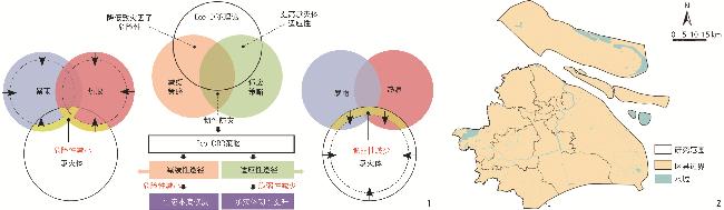
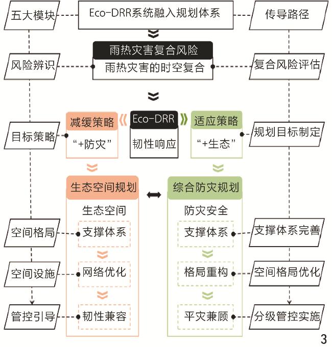
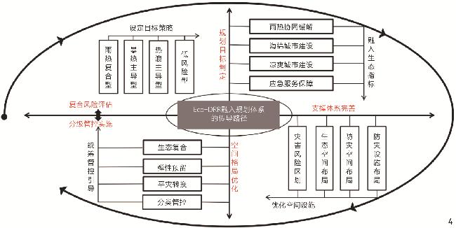
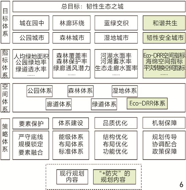
[Methods] This research develops a planning framework grounded in Eco-DRR theory to address CRH disaster risks. First, the research employs a risk assessment methodology driven by multi-source data to overcome the constraints of traditional single-disaster assessment approaches. The research utilizes daily precipitation and maximum temperature data from Shanghai meteorological stations (2011–2023) to identify CRH events using a maximum temporal interval criterion. Subsequently, disaster records of rainstorms and heatwaves within the event time window are extracted as target variables, while raster data of climatic, topographic, geomorphic, and hydrological influencing factors are derived using ENVI and ArcGIS tools as explanatory variables, forming CRH disaster datasets for training a random forest model. The datasets are partitioned into training and testing sets at a 7:3 ratio. The probability of disaster event occurrence is calculated on a grid-by-grid basis. Disaster risks are classified into high, medium, and low levels using the natural breaks classification method (Jenks), visualized for CRH risks on the ArcGIS platform, and ultimately integrated into a bivariate spatial distribution map through a compound risk matrix. Second, Eco-DRR principles are systematically integrated into territorial spatial planning systems to transition from reactive single-disaster mitigation to proactive resilience-driven strategies. The systematic integration of Eco-DRR theory into the aforesaid planning framework establishes an implementation logic of “risk assessment – planning objectives – support system – spatial configuration – management measures” across five core components. Based on the above, the research proposes the following specific pathways. 1) Resilience goal setting: Defining township/subdistrict-level risk zoning and Eco-DRR targets based on citywide compound risk assessment results. 2) Support system development: Constructing an Eco-DRR support system incorporating mitigation and adaptation strategies. 3) Spatial configuration optimization: Determining spatial allocation schemes for Eco-DRR support elements guided by risk assessment outcomes. 4) Hierarchical management implementation: Coordinating management needs for transition between routine and emergency states under the “risk types – spatial features – planning objectives – management hierarchy” framework. Third, horizontal coordination between ecological spaces and comprehensive disaster prevention systems mitigates fragmentation in existing planning frameworks, establishing a replicable model for multi-disaster, multi-system planning for disaster risk reduction. The Eco-DRR theoretical framework resolves conflicts between multiple planning systems by enabling horizontal coordination between ecological spaces and comprehensive disaster prevention planning. Specifically, Eco-DRR is deconstructed into “+ ecology” and “+ disaster prevention” strategies, with “+ ecology” integrated into comprehensive disaster prevention planning, while “+ disaster prevention” is embedded within ecological spatial planning. Eco-DRR’s mitigation and adaptation strategies are implemented, with coordinated ecological and disaster prevention plans serving as the basis for detailed planning.
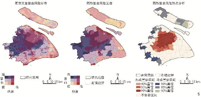
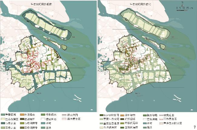
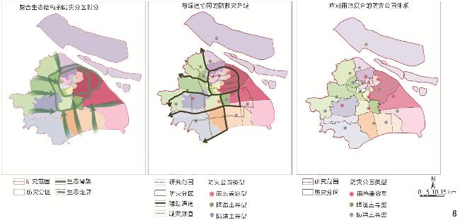
[Results] The research adopts random forest models for analysis to identify CRH events and map their spatial distribution in Shanghai. Results show that CRH disasters predominantly occur between May and September, peaking during the plum rain season and summer months. Annual cumulative durations have increased, exceeding 70 days in the past three years. The high-risk zones for compound risks are concentrated in the central urban areas of Hongqiao, Minhang, and Chuansha districts in Shanghai, as well as surrounding new towns, exhibiting spatial characteristics of “central concentration, peripheral dispersion, and local aggregation”. The spatial distribution patterns of compound risks align with urban development trajectories, with pronounced “rain island” and “heat island” effects. Getis-Ord Gi* analysis reveals that risk hotspots (p<0.05) radiate outward from the urban core to surrounding suburban coldspots. Guided by Eco-DRR theory, dual planning interventions are operationalized: 1) “+ disaster prevention” ecological spatial planning optimization: Eco-DRR constraint indicators embodying the “+ disaster prevention” concept are integrated into Shanghai’s ecological spatial support system. High-risk compound CRH zones are identified as Eco-DRR nodes within the green network, restructuring the outer green belt and suburban green ring. Resilience-compatible zoning is applied based on risk levels. 2) “+ ecology” comprehensive disaster prevention planning optimization: Eco-DRR principles guide “+ ecology” disaster mitigation strategies, including restructuring disaster spaces (shelters, evacuation routes, and zoning) and optimizing safety patterns through risk zoning, route upgrades, and facility improvements. CRH risk zoning informs differentiated construction guidelines, with dual-purpose zoning for normal & emergency states.
[Conclusion] This research aligns with territorial spatial planning mandates to address CRH risks through Eco-DRR mitigation and adaptation strategies, establishing an integrated territorial spatial planning framework for disaster risk reduction. A random forest-based CRH risk assessment model is developed; empirical analysis is conducted in Shanghai to explore planning pathways under the Eco-DRR theory. District-specific resilience objectives are formulated for subdistricts and structured into “+ ecology” and “+ disaster prevention” strategies. This approach fosters horizontal coordination between ecological spaces and disaster mitigation systems, advancing Eco-DRR integration into territorial spatial planning for disaster risk reduction. The planning methodology provides a replicable framework for CRH mitigation and adaptation in eastern coastal cities. Future research should expand applications to diverse compound climate extremes, incorporate advanced modeling techniques for prediction, and deepen investigations into CRH dynamics and blue – green infrastructure effects.
Mingyang BO , Daixin DAI , Wandi LIAO . Resilient Response in Coastal Urban Planning Based on Ecosystem-Based Disaster Risk Reduction: A Case Study of Compound Rainstorm and Heatwave Disaster Risks in Shanghai[J]. Landscape Architecture, 2025 , 32(10) : 80 -88 . DOI: 10.3724/j.fjyl.LA20250130
表1 数据来源Tab. 1 Data sources |
| 数据集 | 数据特征 | 数据来源 |
| 暴雨灾害记录 | 1 000 m×1 000 m分辨率 | 韧性城市规划数据中心(citydata.tongji.edu.cn) |
| 热浪灾害记录 | 1 000 m×1 000 m分辨率 | |
| 逐日气象数据 | 逗号分隔值 (comma-separated values, CSV) | 美国国家海洋和大气管理局(National Oceanic and Atmospheric Administration, NOAA) |
| 气候因子数据 | 30 m×30 m分辨率 | 国家地球系统科学数据中心(www.geodata.cn) |
| 数字高程模型 | 30 m×30 m分辨率 | 中国地理空间数据云平台(www.gscloud.cn) |
| 土地利用 | 10 m×10 m分辨率 | 欧洲航天局(European Space Agency, ESA) |
| 道路数据 | 矢量 | OpenStreetMap(www.openstreetmap.org) |
| 建筑数据 | 矢量 | 百度地图(map.baidu.com) |
表2 应对雨热复合风险的Eco-DRR规划实施指南Tab. 2 Implementation guidelines for Eco-DRR planning in response to compound rainstorm and heatwave risks |
| 复合风险类型 | 传导环节 | |||
| 规划目标制定 | 支撑体系完善 | 空间格局优化 | 分级管控实施 | |
| 雨热复合型 | 雨热风险协同缓解 | 融入海绵与降温功能兼容的Eco-DRR空间指标 | 以存量盘活和功能复合为主,形成集约型空间格局 | 实施生态修复,常态功能向灾时防御功能转换 |
| 暴雨主导型 | 海绵城市建设 | 融入海绵空间设施指标 | 以海绵空间设施改造为主,形成承洪韧性空间格局 | 预留海绵设施,常态功能向灾时调蓄功能转换 |
| 热浪主导型 | 凉爽城市建设 | 融入降温空间设施指标 | 以降温空间设施改造为主,形成凉爽城市空间格局 | 预留降温设施,常态功能向灾时降温功能转换 |
| 低风险型 | 应急服务保障与人员安置 | 融入平灾转换和应急保障空间指标 | 在优化生态安全格局的同时适当增量建设 | 完善应急避险功能,常态功能向灾时服务保障功能转换 |
表3 上海市雨热灾害极端复合事件识别结果Tab. 3 Identification results of extreme compound rainstorm and heatwave disaster events in Shanghai |
| 年份 | 出现次数 | 持续 天数 | 最大 降雨 日期 | 最大日 降雨量 /mm | 最高 气温 日期 | 最高 气温 /℃ |
| 2010 | 2 | 23 | 8月18日 | 88.39 | 8月13日 | 39.4 |
| 2011 | 2 | 47 | 6月18日 | 108.20 | 7月26日 | 36.7 |
| 2012 | 1 | 53 | 8月8日 | 106.17 | 7月5日 | 38.3 |
| 2013 | 1 | 55 | 6月25日 | 60.96 | 7月29日 | 39.0 |
| 2014 | 2 | 43 | 9月2日 | 64.26 | 8月4日 | 35.2 |
| 2015 | 1 | 14 | 7月23日 | 35.81 | 8月4日 | 38.0 |
| 2016 | 3 | 27 | 7月2日 | 67.31 | 7月21日 | 38.7 |
| 2017 | 2 | 45 | 8月19日 | 106.68 | 7月24日 | 38.5 |
| 2018 | 2 | 33 | 8月12日 | 83.31 | 8月12日 | 36.6 |
| 2019 | 1 | 38 | 8月10日 | 82.80 | 7月30日 | 37.0 |
| 2020 | 1 | 45 | 7月6日 | 159.77 | 8月14日 | 37.6 |
| 2021 | 2 | 74 | 7月25日 | 84.84 | 7月13日 | 37.8 |
| 2022 | 1 | 70 | 7月10日 | 35.81 | 7月14日 | 39.7 |
| 2023 | 3 | 78 | 5月26日 | 82.55 | 7月13日 | 38.7 |
表4 基于雨热复合风险类型的防灾减灾规划目标与管控引导Tab. 4 Objectives, control and guidance of disaster risk reduction planning based on the types of compound rainstorm and heatwave disaster risks |
| 风险类型 | 空间分布 | 组团特征 | 规划目标 | 管控引导 |
| 雨热复合型 | 虹桥、闵行、川沙主城副中心及嘉定、奉贤等新城 | 当前规划建设重点区域,预计人口密度将超过1.0万人/km2 | 雨热风险协同缓解 | 实施生态修复工程,推动Eco-DRR与传统防灾设施的功能复合 |
| 暴雨主导型 | 青浦、松江等西部新城和新市镇 | 河网密布,延续了江南水乡传统聚落特征,易发洪涝灾害 | 雨洪管理优先 | 以海绵城市建设为主导,Eco-DRR降温措施协同配合 |
| 热浪主导型 | 中心城区与宝山主城片区 | 老年人口密集,热应激易危害群体健康 | 降温策略优先 | 以凉爽城市建设为主导,Eco-DRR雨洪管理协同配合 |
| 低风险型 | 市域边缘 | 生态条件良好,用地充裕 | 应急服务保障与人员安置 | 推行平灾转换机制,提高保障服务设施的容错率 |
图6 “+防灾”理念下上海市生态空间专项规划逻辑框架优化Fig. 6 Optimization of the logical framework for ecological space sectoral planning of Shanghai under the “+ disaster prevention” concept |
表5 融入“+防灾”约束指标的生态空间支撑体系Tab. 5 An ecological space support system integrating “+ disaster prevention” constraint indicators |
| 支撑体系 | Eco-DRR空间指标 | 海绵空间指标 | 降温空间指标 | 平灾转换空间指标 |
| 公园体系 | 人均公园绿地面积 | 公园下垫面透水率 | 公园绿化覆盖率 | 避难场所面积 |
| 森林体系 | 森林保护率 | 森林透水率 | 森林覆盖率 | 森林建设用地占比 |
| 湿地体系 | 湿地保护率 | 河湖蓄水率 | 河湖水面率 | 生态、生活岸线占比 |
| 廊道体系 | 生态走廊覆盖率 | 生态走廊水面率 | 绿廊通风潜力 | 生态走廊建设用地占比 |
| 绿道体系 | 骨干绿道总长度 | 绿道透水率 | 行道树覆盖率 | 绿道有效宽度 |
表6 基于Eco-DRR的防灾空间设施支撑体系优化策略Tab. 6 Eco-DRR-based optimization strategies for disaster prevention and safety support systems |
| 空间设施 | 传统防灾模式 | “生态+防灾”模式 |
| 面状空间 | 以行政边界划分防灾分区 | 以生态网络界定分区边界,形成防灾屏障,依据风险区划配置Eco-DRR设施 |
| 线状空间 | 以宽度8 m以上的高等级公路为主要防救灾线路 | 低风险区优先拓宽绿道至4 m以上作为防救灾辅助通道,雨热复合型风险区优先发展绿道的Eco-DRR功能作为减灾廊道 |
| 点状空间 | 公园绿地仅作为应急避难场所 | 低风险区优先配置应急保障服务设施用于人员避难,雨热复合型风险区优先发展公园广场的Eco-DRR功能用于灾情缓冲 |
| 防灾设施 | 独立的防灾设施(应急供水厂、应急医疗和物流仓储等) | 推行Eco-DRR设施的平灾功能转换,日常作为公共服务空间,灾时转为应急供水点、物资中转站等防灾设施 |
| [1] |
田健, 曾穗平, 曾坚, 等. 基于智慧-韧性理念的滨海城市雨洪灾害防控规划方法[J]. 西部人居环境学刊, 2022, 37(6): 66-72.
TIAN J, ZENG S P, ZENG J, et al. Planning Method of Coastal City Rain Flood Disaster Prevention and Control Based on the Concept of Intelligence-Resilience[J]. Journal of Human Settlements in West China, 2022, 37(6): 66-72.
|
| [2] |
HORTON D E, JOHNSON N C, SINGH D, et al. Contribution of Changes in Atmospheric Circulation Patterns to Extreme Temperature Trends[J]. Nature, 2015, 522(7557): 465-469.
|
| [3] |
YU Y F, YOU Q L, ZUO Z Y, et al. Compound Climate Extremes in China: Trends, Causes, and Projections[J]. Atmospheric Research, 2023, 286: 106675.
|
| [4] |
赫磊, 解子昂. 走向韧性: 城市综合防灾规划研究综述与展望[J]. 城乡规划, 2021(3): 43-54.
HE L, XIE Z A. Towards Resilience: Review and Prospects of Urban Integrated Disaster Prevention Planning[J]. Urban and Rural Planning, 2021(3): 43-54.
|
| [5] |
戴慎志, 刘婷婷, 高晓昱, 等. 国土空间防灾减灾规划编制体系与实施机制[J]. 城市规划学刊, 2023(1): 48-53.
DAI S Z, LIU T T, GAO X Y, et al. Planning and Implementation Mechanism for Disaster Prevention and Mitigation in Territorial Spatial Planning[J]. Urban Planning Forum, 2023(1): 48-53.
|
| [6] |
王志涛, 王晓卓. 新形势下城市综合防灾规划转型的若干思考[J]. 城市与减灾, 2019(6): 14-18.
WANG Z T, WANG X Z. Thinking on Transformation of Urban Comprehensive Disaster Prevention Plan in Cities Under the New Situation[J]. City and Disaster Reduction, 2019(6): 14-18.
|
| [7] |
戴慎志, 王江波, 刘婷婷. 平灾兼顾的城市医疗卫生防疫设施体系构建策略[J]. 城市规划学刊, 2020(3): 103-108.
DAI S Z, WANG J B, LIU T T. Construction Strategy of Urban Health and Epidemic Prevention Facilities System from the Perspective of Disaster Preparedness at Peaceful Times[J]. Urban Planning Forum, 2020(3): 103-108.
|
| [8] |
段怡嫣, 翟国方, 李文静. 城市韧性测度的国际研究进展[J]. 国际城市规划, 2021, 36(6): 79-85.
DUAN Y Y, ZHAI G F, LI W J. International Research Progress on Measuring Urban Resilience[J]. Urban Planning International, 2021, 36(6): 79-85.
|
| [9] |
LU P W, STEAD D. Understanding the Notion of Resilience in Spatial Planning: A Case Study of Rotterdam, the Netherlands[J]. Cities, 2013, 35: 200-212.
|
| [10] |
彭翀, 左沛文, 李月雯, 等. 城市空间多风险耦合及规划的韧性应对[J]. 城市规划学刊, 2024(5): 88-97.
PENG C, ZUO P W, LI Y W, et al. Urban Multi-risk Coupling and Resilient Responses Through Urban Planning[J]. Urban Planning Forum, 2024(5): 88-97.
|
| [11] |
李含嫣, 王峤, 臧鑫宇, 等. 应对气候变化扰动的城市韧性研究理论进展与实施路径[J]. 安全与环境学报, 2025, 25(4): 1490-1503.
LI H Y, WANG Q, ZANG X Y, et al. Theoretical Advances and Implementation Strategies for Resilience Research Addressing Urban Climate Change Disruptions[J]. Journal of Safety and Environment, 2025, 25(4): 1490-1503.
|
| [12] |
丁元慧, 周强, 刘峰贵, 等. 灾害韧性的研究演变及多维度展望[J]. 灾害学, 2024, 39(1): 109-117.
DING Y H, ZHOU Q, LIU F G, et al. Research Evolution and Multi-dimensional Prospect of Disaster Resilience[J]. Journal of Catastrophology, 2024, 39(1): 109-117.
|
| [13] |
DOSWALD N, ESTRELLA M. Promoting Ecosystems for Disaster Risk Reduction and Climate Change Adaptation: Opportunities for Integration[EB/OL]. [2020-09-05]. https:// www.wetlands.org/publications/promoting-ecosystemsfor-disaster-risk-reduction-and-climate-change-adaptationopportunities-for-integration/.
|
| [14] |
戴代新, 薄茗洋, 戴开宇. 城市生态防减灾中人工智能技术应用的进展与逻辑框架[J]. 灾害学, 2024, 39(2): 145-152.
DAI D X, BO M Y, DAI K Y. Progress and Logical Framework of Artificial Intelligence Technology Application in Urban Ecosystem-Based Disaster Risk Prevention and Reduction[J]. Journal of Catastrophology, 2024, 39(2): 145-152.
|
| [15] |
童彤, 鲍沁星. 基于生态系统的适应与减灾理论在国外城市气候规划中的实践研究[J]. 风景园林, 2022, 29(1): 102-107.
TONG T, BAO Q X. The Application of Ecosystem-Based Adaptation and Disaster Risk Reduction in Foreign Urban Climate Planning[J]. Landscape Architecture, 2022, 29(1): 102-107.
|
| [16] |
RULFOVÁ Z, BERANOVÁ R, PLAVCOVÁ E. Compound Temperature and Precipitation Events in the Czech Republic: Differences of Stratiform Versus Convective Precipitation in Station and Reanalysis Data[J]. Atmosphere, 2021, 12(1): 87
|
| [17] |
CHEN Y, LIAO Z, SHI Y, et al. Detectable Increases in Sequential Flood-Heatwave Events Across China During 1961−2018[J]. Geophysical Research Letters, 2021, 48(6): e2021GL092549
|
| [18] |
NING G C, LUO M, ZHANG W, et al. Rising Risks of Compound Extreme Heat-Precipitation Events in China[J]. International Journal of Climatology, 2022, 42(11): 5785-5795.
|
| [19] |
WU J, CHEN Y, LIAO Z, et al. Increasing Risk from Landfalling Tropical Cyclone-Heatwave Compound Events to Coastal and Inland China[J]. Environmental Research Letters, 2022, 17(10): 105007
|
| [20] |
RICHARDS D R, EDWARDS P J. Using Water Management Infrastructure to Address Both Flood Risk and the Urban Heat Island[J]. International Journal of Water Resources Development, 2018, 34(4): 490-498.
|
| [21] |
LUO Z R, LIU J H, ZHANG S H, et al. Spatiotemporal Evolution of Urban Rain Islands in China Under the Conditions of Urbanization and Climate Change[J]. Remote Sensing, 2022, 14(17): 4159
|
| [22] |
WANG M Y, XU H Q. The Impact of Building Height on Urban Thermal Environment in Summer: A Case Study of Chinese Megacities[J]. PLoS One, 2021, 16(4): e0247786
|
| [23] |
KISHTAWAL C M, NIYOGI D, TEWARI M, et al. Urbanization Signature in the Observed Heavy Rainfall Climatology over India[J]. International Journal of Climatology, 2010, 30(13): 1908-1916.
|
| [24] |
TANG X Z, HUANG X, TIAN J W, et al. A Spatiotemporal Framework for the Joint Risk Assessments of Urban Flood and Urban Heat Island[J]. International Journal of Applied Earth Observation and Geoinformation, 2024, 127: 103686.
|
| [25] |
HE B J, ZHU J, ZHAO D X, et al. Co-benefits Approach: Opportunities for Implementing Sponge City and Urban Heat Island Mitigation[J]. Land Use Policy, 2019, 86: 147-157.
|
| [26] |
DAI D X, BO M Y. A Resilience Enhancement Approach to the Sponge City Based on Ecosystem-Based Disaster Risk Reduction: Taking the Urban Design of Jiangchuanlu Street in Shanghai, China as an Example[J]. Journal of Resources and Ecology, 2023, 14(6): 1113-1126.
|
| [27] |
DAI D X, BO M Y, MAO J J. A Comparative Study of Eco-DRR and Traditional Chinese Ecological Knowledge for Elevated Urban Temperature Disasters[C]//RENAUD F G, SUDMEIER-RIEUX K, ESTRELLA M, et al. Ecosystem-Based Disaster Risk Reduction and Adaptation in Practice. Springer International Publishing AG, 2016: 81-89.
|
| [28] |
ERLWEIN S, ZÖLCH T, PAULEIT S. Regulating the Microclimate with Urban Green in Densifiying Cities: Joint Assessment on Two Scales[J]. Building and Environment, 2021, 205: 108233.
|
| [29] |
曾坚, 田健, 王倩雯, 等. 国土空间规划体系中的气候韧性及适灾承洪理论: 以闽三角地区为例[J]. 中国科学: 技术科学, 2023, 53(10): 1713-1727.
ZENG J, TIAN J, WANG Q W, et al. Theory of Climate Resilience, Disaster Adaptation, and Flood Mitigation in Territorial Spatial Planning Systems: A Case Study of the Fujian Delta Region[J]. Scientia Sinica (Technologica), 2023, 53(10): 1713-1727.
|
| [30] |
冉静, 蒋晓慧, 赫磊, 等. 城市平急两用公共基础设施的类型及空间体系与规划建设要点[J]. 城市规划学刊, 2024(5): 98-105.
RAN J, JIANG X H, HE L, et al. Typology and Spatial System of Urban Dual-Use Public Infrastructure and the Key Points in Planning[J]. Urban Planning Forum, 2024(5): 98-105.
|
| [31] |
ZHANG J L, XU W, QIAO Y, et al. A New Method to Identify the Maximum Time Interval Between Individual Events in Compound Rainstorm and Heatwave Events[J]. International Journal of Disaster Risk Science, 2024, 15(3): 453-466.
|
| [32] |
RAFIEI-SARDOOI E, AZAREH A, CHOUBIN B, et al. Evaluating Urban Flood Risk Using Hybrid Method of TOPSIS and Machine Learning[J]. International Journal of Disaster Risk Reduction, 2021, 66: 102614.
|
| [33] |
XUE F, YAO E J. Adopting a Random Forest Approach to Model Household Residential Relocation Behavior[J]. Cities, 2022, 125: 103625.
|
| [34] |
YANG Y J, SASAKI K, CHENG L, et al. Gender Differences in Active Travel Among Older Adults: Non-linear Built Environment Insights[J]. Transportation Research Part D: Transport and Environment, 2022, 110: 103405.
|
| [35] |
LIU J X, XIAO L Z. Non-linear Relationships Between Built Environment and Commuting Duration of Migrants and Locals[J]. Journal of Transport Geography, 2023, 106: 103517.
|
| [36] |
ADITIAN A, KUBOTA T, SHINOHARA Y. Comparison of GIS-Based Landslide Susceptibility Models Using Frequency Ratio, Logistic Regression, and Artificial Neural Network in a Tertiary Region of Ambon, Indonesia[J]. Geomorphology, 2018, 318: 101-111.
|
| [37] |
段进, 赵民, 赵燕菁, 等. “国土空间规划体系战略引领与刚性管控的关系”学术笔谈[J]. 城市规划学刊, 2021(2): 6-14.
DUAN J, ZHAO M, ZHAO Y J, et al. Symposium on the Relationship Between Strategic Guidance and Regulatory Rigidity of the Territorial Spatial Planning System[J]. Urban Planning Forum, 2021(2): 6-14.
|
| [38] |
上海市规划和自然资源局.上海市城市总体规划(2017—2035年)[EB/OL].[2025-01-20].https://www.shanghai.gov.cn/newshanghai/xxgkfj/2035004.pdf.
Shanghai Municipal Planning and Natural Resources Bureau. Shanghai Master Plan (2017−2035) [EB/OL]. [2025-01-20]. https://www.shanghai.gov.cn/newshanghai/xxgkfj/2035004.pdf.
|
| [39] |
王彬, 金忠民, 陈圆圆. “上海2035”总规指引下上海市生态空间专项规划编制研究[J]. 上海城市规划, 2023(2): 52-59.
WANG B, JIN Z M, CHEN Y Y. Study on Shanghai Ecological Space Sectoral Planning Under the Guidance of “Shanghai 2035” Master Plan[J]. Shanghai Urban Planning Review, 2023(2): 52-59.
|
| [40] |
上海市政府.上海市生态空间规划(2021—2035)[EB/OL].(2021-06-05)[2024-02-23]. https://lhsr.sh.gov.cn/zcqfzgh/20210607/cd5dac3296694238b33a82db0293fcd7.html
Shanghai Municipal Government. Shanghai Ecological Space Planning (2021−2035)[EB/OL]. (2021-06-05) [2024-02-23]. https://lhsr.sh.gov.cn/zcqfzgh/20210607/cd5dac3296694238b33a82db0293fcd7.html
|
| [41] |
住房和城乡建设部.城市综合防灾规划标准: GB/T 51327—2018[S].北京: 中国建筑工业出版社.
Ministry of Housing and Urban-Rural Development of the People’s Republic of China. Urban Comprehensive Disaster Prevention Planning Standards: GB/T 51327 – 2018[S]. Beijing: China Architecture & Building Press.
|
| [42] |
上海市应急管理局.上海市综合防灾规划(2022—2035年)[EB/OL].[2025-01-20].https://www.taibo.cn/p/86479.
Shanghai Municipal Emergency Management Bureau. Shanghai Comprehensive Disaster Prevention Plan (2022−2035)[EB/OL]. [2025-01-20].https://www.taibo.cn/p/86479.
|
| [43] |
ZENNARO F, FURLAN E, SIMEONI C, et al. Exploring Machine Learning Potential for Climate Change Risk Assessment[J]. Earth-Science Reviews, 2021, 220: 103752.
|
/
| 〈 |
|
〉 |