
Spatial Characteristics and Influencing Factors of Human Settlement Environment in the Kuye River Basin
|
ZHANG Zhonghua, Ph.D., is a professor and doctoral supervisor in the College of Architecture, Xi’an University of Architecture and Technology. His research focuses on theory and method of territorial spatial planning |
|
WU Hao is a master student in the College of Architecture, Xi’an University of Architecture and Technology. His research focuses on urban and rural planning and design |
Received date: 2024-12-24
Revised date: 2025-04-15
Online published: 2025-12-10
Copyright
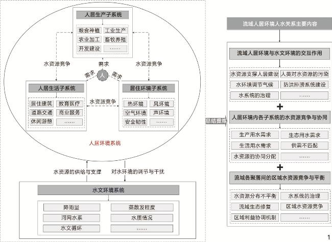
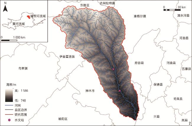
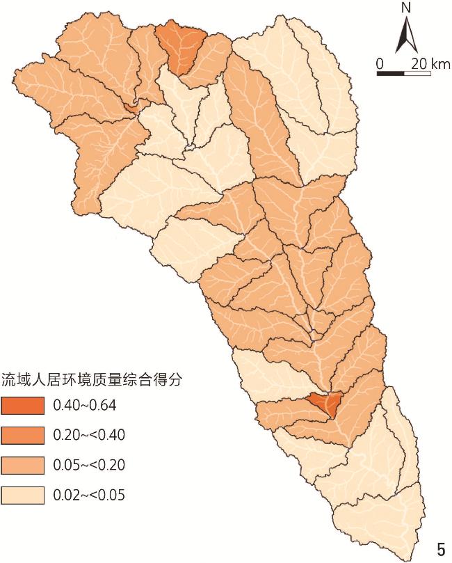
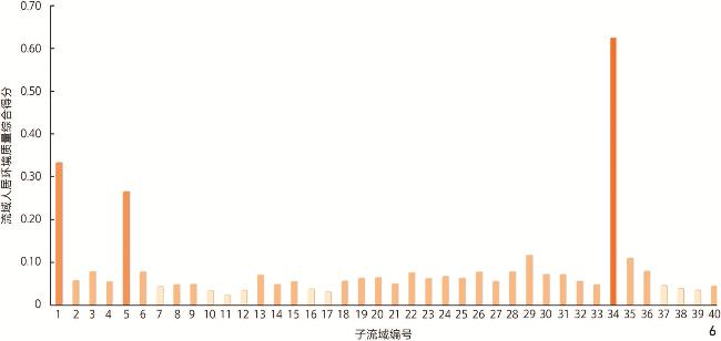
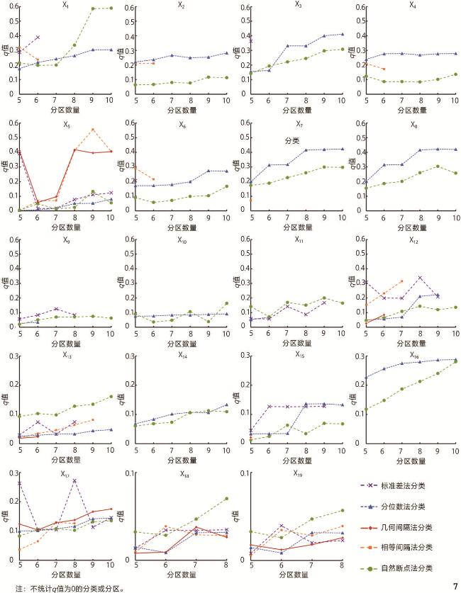
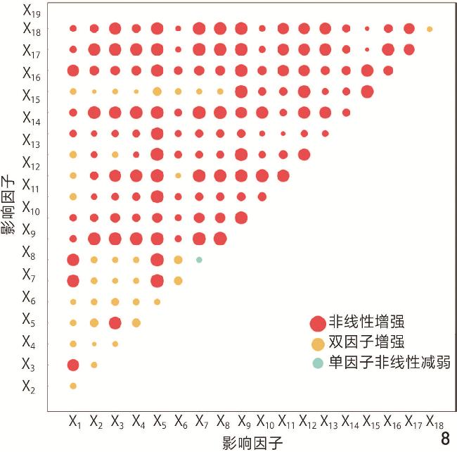
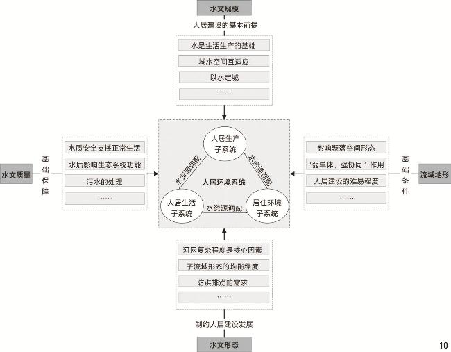
[Objective] The Kuye River Basin (the “Basin”) is one of the typical basins in the arid and semi-arid areas in the middle reaches of the Yellow River. Under the human settlement development mode driven by the energy industry, the water supply shortage, serious soil erosion, incoordination between urban space and water space, and water resources pollution in the Basin are becoming increasingly prominent. From living by water and grass of early human beings to today’s “Four Determinations Based on Water”, the complex relationship between people and water is an important clue for the formation and development of human civilization, and the harmonious relationship between people and water in river basins is an important basis for achieving sustainable development. Exploring the complex relationship between human settlement environment and hydrological environment in the Kuye River Basin from the perspective of human – water relationship is helpful to guide the harmonious symbiotic development of human settlement environment and hydrological environment in the Basin, and then promote the high-quality development of human settlement environment in the Basin. [Methods] The evaluation system for the quality of human settlement environments in sub-basins has been established, with the weight of each index factor determined using the entropy method. This approach aims to elucidate the spatial characteristics of human settlement environment quality within the sub-basins of the Kuye River Basin. Utilizing ArcSWAT 2012 software, hydrological simulations are conducted for the Kuye River Basin. Input data includes DEM (digital elevation model) data, soil type data, and meteorological information specific to the basin, enabling the simulation and acquisition of hydrological factors such as sub-basin boundary and river network grade. Geographical detector is a method employed to identify spatial differentiation and uncover its underlying driving forces. By selecting optimal parameters, geographical detector is utilized to examine influencing factors on the quality of human settlement environment in the Basin from various perspectives: scale, quality, and form of the hydrological environment. The primary factors influencing spatial differentiation in the quality of human settlement environment are analyzed based on results obtained from both single-factor detection and interactive detection methods. [Results] The spatial differentiation in the quality of human settlement environment in the Kuye River Basin is characterized by “local core agglomeration, and descending in all directions along the main river channel”, and the potential of optimizing the quality of human settlement environment in each sub-basin is very different. The shape and development degree of river network are the core factors influencing the human settlement environment in river basin. The quality of human settlement environment in river basin can be optimized by adjusting the density and length – width ratio of river network. The coupling relationship between scale, quality and source and sink of water resources is the main factor influencing the quality of human settlement environment in a basin. The systematic balance of scale, quality and source and sink of water resources should be considered in the development of human settlements in a basin to avoid the deterioration of water resources caused by excessive interference in a certain aspect. The roundness and length – width ratio of a basin are the secondary factors influencing the human settlement environment in the basin. The balanced and concentrated sub-basins are conducive to the formation of abundant water resources and efficient settlement spatial structure. Basin terrain is an important factor influencing the human settlement environment in a basin, and the impact mode on the quality of the human settlement environment in a basin is “weak monomer, strong synergy”. The terrain factors need to cooperate with river network form, water resource scale and other factors to play a role. [Conclusion] 1) There exists significant spatial differentiation in the quality of human settlement environment in the Kuye River Basin. 2) The quality of human settlement environment in the basin is the result of long-term coupling of multiple factors such as hydrological scale, hydrological form, hydrological quality and watershed topography. 3) There is a complex interaction between the human settlement environment and the hydrological environment in the basin. The quality of human settlement environment in the basin should be improved and optimized based on the harmonious relationship between human and water, and the relationship between human and water in the basin should be optimized from multiple aspects, such as the optimization of water resource supply and demand, the regional planning of water resources, the coordinated balance of water resources within the human settlement environment and the coupling of human and water space, so as to promote the high-quality development of the human settlement environment in the Basin. With sub-basin as the basic unit, the optimization strategy of human settlement environment is determined according to local conditions.
Zhonghua ZHANG , Hao WU . Spatial Characteristics and Influencing Factors of Human Settlement Environment in the Kuye River Basin[J]. Landscape Architecture, 2025 , 32(6) : 96 -105 . DOI: 10.3724/j.fjyl.LA20240129
表1 流域人居环境质量的评价指标Tab. 1 Evaluation indicators of the quality of human settlement environment in the Basin |
| 综合层 | 系统层 | 指标层 | 指标属性 | 单位 | 指标说明 |
| 流域人居环境质量 | 人居生活 质量 | 交通可达性 | 正向 | km/km2 | 子流域内道路长度与流域面积的比值 |
| 公共服务设施 | 正向 | 子流域内公共服务设施POI核密度值的总和 | |||
| 行政服务设施 | 正向 | 子流域内村委会、镇政府等行政服务设施POI核密度值的总和 | |||
| 商业服务设施 | 正向 | 子流域内商业服务设施POI核密度值的总和 | |||
| 人居生产 质量 | 生产总值密度 | 正向 | 万元/km2 | 子流域生产总值与流域面积的比值 | |
| 开发强度 | 正向 | m2/hm2 | 子流域内总建筑面积与流域面积的比值(容积率) | ||
| 耕地比例 | 正向 | % | 子流域内耕地面积与流域面积的比值 | ||
| 建设用地比例 | 正向 | % | 子流域内建设用地面积与流域面积的比值 | ||
| 企业数密度 | 正向 | 个/km2 | 子流域内企业数量与流域面积的比值 | ||
| 地球夜间灯光分布指数 | 正向 | 子流域内夜间灯光指数总和与流域面积的比值 | |||
| 人口特征 | 人口密度 | 正向 | 人/hm2 | 子流域内人口规模与流域面积的比值 | |
| 老龄化率 | 负向 | % | 子流域内65岁及以上人数与流域人口规模的比值 | ||
| 人均GDP | 正向 | 万元/人 | 子流域内年GDP总量与流域人口规模的比值 | ||
| 常住人口规模 | 正向 | 人 | 子流域的常住人口数量 | ||
| 环境舒适度 | 碳排放量密度 | 负向 | t/km2 | 子流域内碳排放总量与流域面积的比值 | |
| PM2.5浓度 | 负向 | ${\text{μ}}{\rm{g}} $/m3 | 子流域内年PM2.5浓度最大值 | ||
| O3浓度 | 负向 | ${\text{μ}}{\rm{g}} $/m3 | 子流域内年O3浓度最大值 | ||
| SO2浓度 | 负向 | ${\text{μ}}{\rm{g}} $/m3 | 子流域内年SO2浓度最大值 | ||
| 气候舒适度 | 正向 | 基于《人居环境气候舒适度评价》标准,采用温湿指数表征气候舒适度,计算式K=T−0.55(1−H)(T−14.4),其中:K为温湿指数;T为年平均气温,℃;H为年平均相对湿度,% |
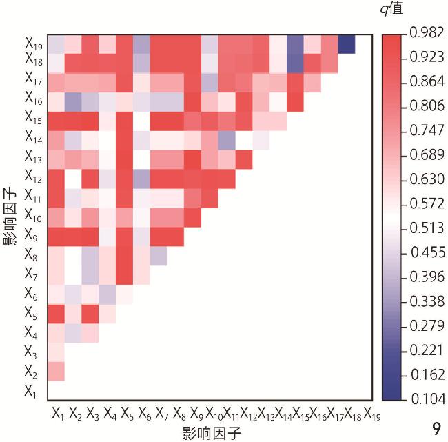
表2 流域人居环境质量的影响因子Tab. 2 Factors influencing the quality of human settlement environment in the Basin |
| 类型 | 影响因子 | 单位 | 指标说明 |
| 水文规模 | 年产水能力(X1) | mm/km2 | 子流域内年产水总量与流域面积的比值,反映了流域内年净产水能力 |
| 蒸散发程度(X2) | mm/km2 | 子流域内年实际蒸散发量与流域面积的比值,反映了水资源的蒸散发流失程度 | |
| 径流系数(X3) | 径流量与降水量的比值,是描述流域径流量产生能力的重要参数 | ||
| 降雨能力(X4) | mm/km2 | 子流域内年降雨量总和与流域面积的比值,是决定区域水资源规模的关键因素 | |
| 水文质量 | 土壤含水程度(X5) | mm/km2 | 子流域内年土壤含水量与流域面积的比值,反映了土壤的含水量程度 |
| 产沙情况(X6) | t/hm2 | 流域内河流的年泥沙量情况,是反映河流水质的重要指标 | |
| 有机氮含量(X7) | kg/hm2 | 流域内河流的年有机氮含量,是反映河流水质的重要指标 | |
| 有机磷含量(X8) | kg/hm2 | 流域内河流的年有机磷含量,是反映河流水质的重要指标 | |
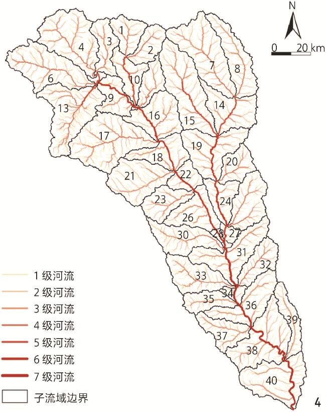
| 水文形态 | 河网密度(X9) | km/km2 | 子流域内河网总长与流域面积的比值,反映了河网的疏密程度,是描述河网特征的重要参数 |
| 区域水系曲度(X10) | 借鉴相关研究,采用加权平均值计算区域水系曲度$S={\displaystyle\sum }_{i=1}^{m}\dfrac{ {L}_{ {\rm{a} },i} }{ {L}_{ {\rm{r} } } }\dfrac{ {L}_{ {\rm{a} },i} }{ {L}_{ {\rm{s} },i} }$ 式中:i为河段序号;m为河段总数;L a,i为第i条河流的实际长度,km;L s,i为第i条河流起止断面间的直线距离,km;L r为河流总长度,km;L a,i/L r即为权重 | ||
| 主河道占比(X11) | % | 子流域内主河道长度与河道总长的比值 | |
| 分枝比(X12) | 分枝比为某等级河流数目与更高一级河流数目的比值,流域内一般有多个不同等级的河流,单个河流的分枝比不能反映整个流域的河流分支程度。该领域学者一般以${\text{ω}} $与${\rm{lg}}N_{\text{ω}} $线性拟合(横坐标为${\text{ω}} $,纵坐标为${\rm{lg}}N_{\text{ω}} $)所得到回归直线斜率绝对值的反对数表示分枝比($ {R}_{\mathrm{b}} $),其中${\text{ω}} $为河流级别序号,$N_{\text{ω}} $为第${\text{ω}} $级河流的数目 | ||
| 长度比(X13) | 长度比为某等级河流平均长度与更高一级河流平均长度的比值,长度比反映了水系的发育程度。与分枝比同理,可以通过Origin软件得到${\text{ω}} $与${\rm{lg}}N_{\text{ω}} $线性拟合直线的斜率(横坐标为${\text{ω}} $,纵坐标为${\rm{lg}}L_{\text{ω}} $),进而计算斜率绝对值的反对数,得到长度比($ {R}_{\mathrm{l}} $),其中${\text{ω}} $为河流级别序号,$L_{\text{ω}} $为第${\text{ω}} $级河流的平均长度 | ||
| 分维数(X14) | 分维数(D)为分枝比(R b)与长度比($ {R}_{\mathrm{l}} $)的常对数比值,反映了水系的复杂程度,计算式$ D=\dfrac{\mathrm{l}\mathrm{g}{R}_{\mathrm{b}}}{\mathrm{l}\mathrm{g}{R}_{\mathrm{l}}} $ | ||
| 流域长宽比(X15) | 流域长宽比(A)是反映流域轮廓形态的重要指标,计算式A=L/W,其中L为流域内干流起点至终点的坐标距离,W为流域宽度。W=S/L,S为流域面积 | ||
| 流域圆度率(X16) | 指流域面积与相同周长的圆形面积之比,是流域形状分析中的重要指标 | ||
| 流域地形 | 平均高程(X17) | m | 各个子流域高程的平均值,通过ArcGIS 10.5对DEM数据分区统计得到 |
| 平均坡度(X18) | ° | 各个子流域坡度的平均值,通过ArcGIS 10.5对坡度数据分区统计得到 | |
| 平均起伏度(X19) | m | 各子流域最大高程值和最小高程值的差值,反映了地势起伏特征 |
表3 单因子探测结果Tab. 3 Results of single-factor detection |
| 因子 | 皮尔逊相关性 | q值 |
| 注:*表示在0.05级别(双尾)相关性显著;**表示在0.01级别(双尾)相关性显著。 | ||
| X1 年产水能力 | 0.717** | 0.589 |
| X2 蒸散发程度 | 0.712** | 0.283 |
| X3 径流系数 | 0.042 | 0.412 |
| X4 降雨能力 | 0.726** | 0.420 |
| X5 土壤含水程度 | 0.752** | 0.557 |
| X6 产沙情况 | 0.639** | 0.292 |
| X7 有机氮含量 | 0.714** | 0.423 |
| X8 有机磷含量 | 0.213 | 0.424 |
| X9 河网密度 | -0.335* | 0.124 |
| X10 区域水系曲度 | 0.517** | 0.165 |
| X11 主河道占比 | 0.439** | 0.199 |
| X12 分枝比 | -0.373* | 0.339 |
| X13 长度比 | -0.338* | 0.164 |
| X14 分维数 | -0.065 | 0.133 |
| X15 流域长宽比 | -0.338* | 0.136 |
| X16 流域圆度率 | 0.683** | 0.290 |
| X17 平均高程 | -0.358* | 0.277 |
| X18 平均坡度 | -0.078 | 0.070 |
| X19 平均起伏度 | -0.080 | 0.057 |
文中图表均由作者绘制,其中
| [1] |
汪芳, 刘永, 贺金生, 等. 流域人居系统科学的框架探索与研究展望[J]. 自然资源学报, 2024, 39(5): 997-1007.
WANG F, LIU Y, HE J S, et al. River Basin Habitats Science: Framework and Prospects[J]. Journal of Natural Resources, 2024, 39(5): 997-1007.
|
| [2] |
左其亭. 人水关系学的基本原理及理论体系架构[J]. 水资源保护, 2022, 38(1): 1-6.
ZUO Q T. Basic Principles and Theoretical System of Human-Water Relationship Discipline[J]. Water Resources Protection, 2022, 38(1): 1-6.
|
| [3] |
左其亭, 吴青松, 金君良, 等. 区域水平衡基本原理及理论体系[J]. 水科学进展, 2022, 33(2): 165-173.
ZUO Q T, WU Q S, JIN J L, et al. The Basic Principle and Theoretical System of Regional Water Balance[J]. Advances in Water Science, 2022, 33(2): 165-173.
|
| [4] |
顾恬玮, 彭建, 姜虹, 等. 流域国土空间生态修复: 理论认知与规划要点[J]. 自然资源学报, 2023, 38(10): 2464-2474.
GU T W, PENG J, JIANG H, et al. Watershed-Based Territorial Ecological restoration: Theoretical Cognition and Key Planning Issues[J]. Journal of Natural Resources, 2023, 38(10): 2464-2474.
|
| [5] |
付嫣然, 林志森, 李玲秀, 等. 水环境影响下明代福建梅花所城海防聚落空间营建[J]. 风景园林, 2024, 31(4): 133-139.
FU Y R, LIN Z S, LI L X, et al. Space Construction of Meihua Fortress Coastal Defense Settlement in Fujian in Ming Dynasty Under the Influence of Water Environment[J]. Landscape Architecture, 2024, 31(4): 133-139.
|
| [6] |
李慧, 邓佳伟, 李亚鑫, 等. 秦岭北麓典型流域径流对气候和土地利用变化的响应: 以灞河流域为例[J]. 生态环境学报, 2024, 33(5): 802-811.
LI H, DENG J W, LI Y X, et al. Impacts of Climate and Land Use Change on Runoff in Typical Basin of Northern Foothills of Qinling Mountains: Case Study of Bahe River Basin[J]. Ecology and Environmental Sciences, 2024, 33(5): 802-811.
|
| [7] |
李雪, 张婧, 于婉晴, 等. 京杭运河杭州段城市景观格局对河网水环境的影响[J]. 生态学报, 2021, 41(13): 5242-5253.
LI X, ZHANG J, YU W Q, et al. Impact of the Urban Landscape Pattern in the Hangzhou Section of the Beijing-Hangzhou Grand Canal on the River Aquatic Environment[J]. Acta Ecologica Sinica, 2021, 41(13): 5242-5253.
|
| [8] |
关莹莹, 李雪铭, 杨俊, 等. 基于地理加权回归模型的辽宁省城市人居环境综合适宜性评价[J]. 地理科学, 2022, 42(12): 2097-2108.
GUAN Y Y, LI X M, YANG J, et al. Comprehensive Suitability Evaluation of Urban Human Settlements Based on GWR: A Case Study of Liaoning Province[J]. Geographical Science, 2022, 42(12): 2097-2108.
|
| [9] |
赵宏波, 谷天顺, 孙东琪, 等. “三生” 功能视角下黄河流域城市人居环境动态演变与机制[J]. 地理学报, 2023, 78(12): 2973-2999.
ZHAO H B, GU T S, SUN D Q, et al. Dynamic Evolution and Influencing Mechanism of Urban Human Settlements in the Yellow River Basin from the Perspective of “Production – Living – Ecological” Function[J]. Acta Geographica Sinica, 2023, 78(12): 2973-2999.
|
| [10] |
汪芳, 安黎哲, 党安荣, 等. 黄河流域人地耦合与可持续人居环境[J]. 地理研究, 2020, 39(8): 1707-1724.
WANG F, AN L Z, DANG A R, et al. Human-Land Coupling and Sustainable Human Settlements in the Yellow River Basin[J]. Geographical Research, 2020, 39(8): 1707-1724.
|
| [11] |
汪芳, 苗长虹, 刘峰贵, 等. 黄河流域人居环境的地方性与适应性: 挑战和机遇[J]. 自然资源学报, 2021, 36(1): 1-26.
WANG F, MIAO C H, LIU F G, et al. The Locality and Adaptability of Human Settlements in the Yellow River Basin: Challenges and Opportunities[J]. Journal of Natural Resources, 2021, 36(1): 1-26.
|
| [12] |
郭巧玲, 韩振英, 丁斌, 等. 窟野河流域径流变化及其影响因素研究[J]. 水资源保护, 2017, 33(5): 75-80.
GUO Q L, HAN Z Y, DING B, et al. Study of Runoff Variation Characteristics and Influence Factors in Kuye River[J]. Water Resources Protection, 2017, 33(5): 75-80.
|
| [13] |
杨智勇, 牛健植, 樊登星, 等. 基于SWAT和PLUS模型的窟野河流域径流对土地利用变化的响应及预测[J]. 水土保持学报, 2024, 38(1): 289-299.
YANG Z Y, NIU J Z, FAN D X, et al. Response and Prediction of Runoff to Land Use Change in Kuye River Basin Based on SWAT and PLUS Models[J]. Journal of Soil and Water Conservation, 2024, 38(1): 289-299.
|
| [14] |
王劲峰, 徐成东. 地理探测器: 原理与展望[J]. 地理学报, 2017, 72(1): 116-134.
WANG J F, XU C D. Geodetector: Principle and Prospective[J]. Acta Geographica Sinica, 2017, 72(1): 116-134.
|
| [15] |
李琛, 吴映梅, 高彬嫔, 等. 高原湖泊乡村聚落空间分异及驱动力探测: 以环洱海地区为例[J]. 经济地理, 2022, 42(4): 220-229.
LI C, WU Y M, GAO B P, et al. Spatial Differentiation and Driving Factors of Rural Settlement in Plateau Lake: A Case Study of the Area Around the Erhai[J]. Economic Geography, 2022, 42(4): 220-229.
|
| [16] |
SONG Y Z, WANG J F, GE Y, et al. An Optimal Parameters-Based Geographical Detector Model Enhances Geographic Characteristics of Explanatory Variables for Spatial Heterogeneity Analysis: Cases with Different Types of Spatial Data[J]. GIScience & Remote Sensing, 2020, 57(5): 593-610.
|
| [17] |
孙泽笑, 赵邦宏, 秦安臣, 等. 生态脆弱区乡村旅游可持续发展测度及影响因素分析: 以昆明市东川区为例[J]. 生态经济, 2022, 38(3): 157-163.
SUN Z X, ZHAO B H, QIN A C, et al. Evaluation of Sustainable Development of Rural Tourism in Ecologically Fragile Areas and Analysis of Influencing Factors: Taking Dongchuan District of Kunming as an Example[J]. Ecological Economy, 2022, 38(3): 157-163.
|
| [18] |
田达睿, 关震, 李宏鹏, 等. 黄土高原“河谷次沟”人居发展程度及影响因素研究: 以无定河流域为例[J]. 人文地理, 2024, 39(2): 124-132.
TIAN D R, GUAN Z, LI H P, et al. Human Settlement Development Level and Influencing Factors in “Valley Sub-gully” of Loess Plateau: A Case Study of Wuding River Basin[J]. Human Geography, 2024, 39(2): 124-132.
|
| [19] |
姜海宁, 郑舒婷, 杨琪, 等. 黄河流域资源型城市人居环境韧性水平演化及其障碍度[J]. 资源科学, 2024, 46(10): 2047-2063.
JIANG H N, ZHENG S T, YANG Q, et al. Change of Human Settlement Resilience and Its Obstacle Degree in Resource-Based Cities in the Yellow River Basin[J]. Resources Science, 2024, 46(10): 2047-2063.
|
| [20] |
刘滨谊, 高文琳. 长江三角洲人居环境地方性体系化构建及其演变评估[J]. 中国园林, 2023, 39(4): 6-13.
LIU B Y, GAO W L. Systematic Construction of Human Settlement Locality in Yangtze River Delta and Its Evolution Assessment[J]. Chinese Landscape Architecture, 2023, 39(4): 6-13.
|
| [21] |
马迎雪, 郭巍. 水利建设驱动下的三北平原传统人居环境体系研究[J]. 风景园林, 2025, 32(3): 134-142.
MA Y X, GUO W. Research on Traditional Human Settlement Environment System in the Three-North Plain Driven by Water Conservancy Construction[J]. Landscape Architecture, 2025, 32(3): 134-142.
|
/
| 〈 |
|
〉 |