
Aesthetic Value Assessment Coupled with Landscape Character Assessment for Hengshan Mountain Scenic Area
|
ZHAO Renjing, Ph.D., is a lecturer in the School of Architecture, Zhengzhou University, and a postdoctoral researcher in the School of History, Zhengzhou University. Her research focuses on landscape planning and design |
|
XING Bingtai is a master student in the School of Architecture, Zhengzhou University. His research focuses on architectural design and theory |
|
WANG Yuqian, Ph.D., is a lecturer in the School of History, Zhengzhou University, and a member of the Historical Society of Water Conservancy under the Chinese Hydraulic Engineering Society. His research focuses on history of water conservancy and environmental history |
Received date: 2024-09-11
Revised date: 2025-04-07
Online published: 2025-12-10
Copyright
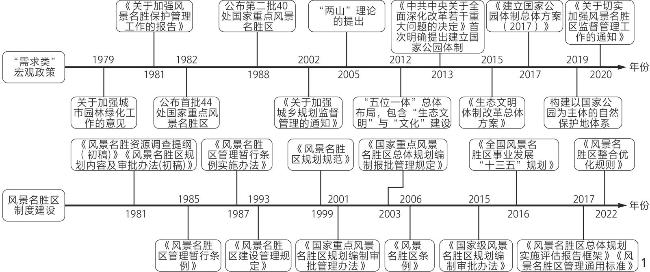
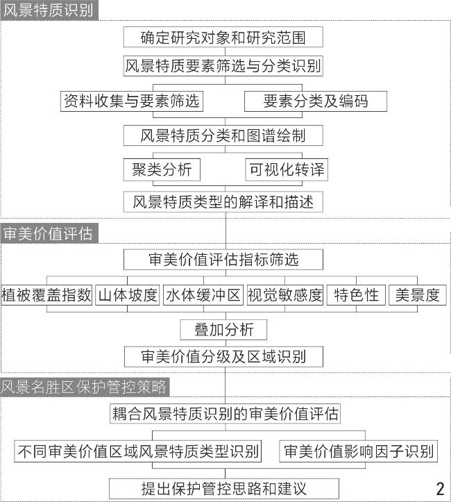
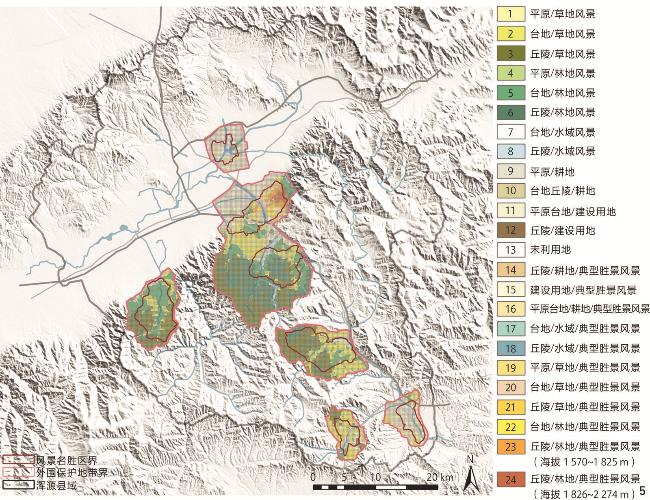
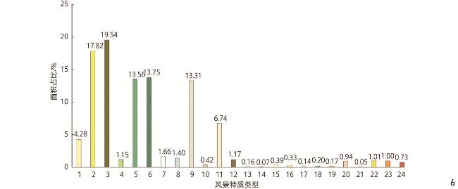
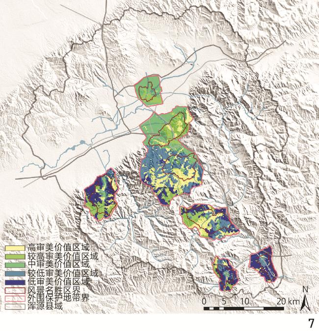
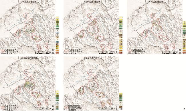
[Objective] In order to align with international standards and promote the construction of a global ecological civilization while ensuring the distinctive protection of China’s natural and cultural resources, China has gradually clarified a plan for deepening the reform of a protected area system mainly composed of national parks. Scenic and historic areas encompass natural and cultural landscapes with unique Chinese characteristics within the national territory of China, and their management system has been continuously improved over the past forty years of development. The scattered layout of multiple areas in Hengshan Mountain has led to an imbalance in the protection, control, inheritance, and development of scenic resources in each area. In the context of the reconstruction of the protected area system, how to respond to the protection and control demands of scenic and historic areas remains an issue in urgent need of exploration.In the context of the new era, this research attempts to, by coupling landscape character assessment with aesthetic value assessment, explore the management and protection of scenic and historic areas, and explain the internal temporal and spatial order and correlation reflected in various types of landscapes, so as to help reduce the fragmentation and incompleteness of landscapes, expand the protection boundaries, connotation boundaries, and time boundaries of landscape resources. The research can assist in delineating the key protection areas of scenic and historic areas guided by aesthetic values, thereby achieving overall protection from point scenery to area scenery. The research can also provide new perspectives for solving a series of problems in the process of integrating and optimizing scenic spots, such as the demand for sightseeing activities, conflicts in urban development, and inheritance of ecological and cultural values, and be able to improve the international heritage aesthetic assessment system from a Chinese perspective. [Methods] Based on the guidance ideas, evaluation methods, technical platforms, and conclusion descriptions of relevant landscape character assessment at home and abroad, and on the basis of determining the scope of the research object, a research framework for aesthetic value assessment coupled with landscape character assessment for Hengshan Mountain Scenic Area is constructed through the combination of elbow method, K-means, entropy weight method, and TOPSIS method, which includes two stages: landscape character assessment and aesthetic value assessment. The stage of landscape character assessment mainly includes three steps: 1) Screening and classified identification of landscape character elements; 2) classification and mapping of landscape character; 3) translation and description of landscape character types. The stage of aesthetic value assessment mainly includes two steps: 1) Screening of aesthetic value assessment indicators; 2) aesthetic value grading and regional identification. Taking the Hengshan Mountain Sceinc Area, which has a scattered layout of multiple protected areas, as an example, this research conducts an aesthetic value assessment practice couple with the identification of landscape characters. [Results] This research screens and classifies the landscape character elements of the Hengshan Mountain Sceinc Area, and uses ArcGIS 10.6 to encode and visualize the classified elements, with the spatial area ratio and distribution characteristics of each element being identified. By virtue of the ArcGIS 10.6 spatial analysis tool, 14,738 150 m × 150 m cells are constructed within the research scope of Hengshan Mountain Sceinc Area, and a gridded geographic information database of various elements is established. Additionally, the research identifies 24 types and zones of landscape characters in Hengshan Mountain Sceinc Area, screens and classifies the aesthetic value assessment indicators of Hengshan Mountain Sceinc Area, and constructs a grid database for each assessment element. The research also conducts a 5-level assessment, classification and zoning of aesthetic value. It is found that within the core area and peripheral protected areas of Hengshan Mountain Sceinc Area, the distribution ratio of aesthetic value zones at all levels is relatively balanced. The distribution characteristics of different levels of aesthetic value zones and the types of landscape characters covered are analyzed, and the main factors affecting aesthetic value are identified based on the types of landscape characters included in various levels of aesthetic value zones, including cultural scenic spots, vegetation coverage index, and water. [Conclusion] The research on aesthetic value assessment coupled with landscape character assessment offers a possibility of determining the protection intensity and utilization methods of scenic and historic areas based on the difference in aesthetic value, providing a more macro perspective for the protection of scenic and historic areas. The research expands the scope of assessment objects, screens assessment elements that reflect the historical and cultural characteristics of scenic and historic areas, and balances the subjectivity and objectivity of assessment methods. The assessment results illustrate the landscape character types and aesthetic value features of scenic and historic areas in the form of a “picture”, which can effectively connect with higher-level planning, promote the balanced development of various areas and types of landscape resources, and guide the resilient protection and sustainable development of scenic and historic areas. Under the research idea that resource characteristics, control objectives, and value orientation jointly determine protection norms, this research focuses on explaining the feasibility of evaluating the overall, refined, and targeted protection of scenic and historic areas, as well as the necessity of balancing the protection and utilization of scenic and historic areas through assessment and coordination under the management concept of “maximizing the scope of protection”.
Renjing ZHAO , Bingtai XING , Yuqian WANG . Aesthetic Value Assessment Coupled with Landscape Character Assessment for Hengshan Mountain Scenic Area[J]. Landscape Architecture, 2025 , 32(6) : 123 -131 . DOI: 10.3724/j.fjyl.202409110531
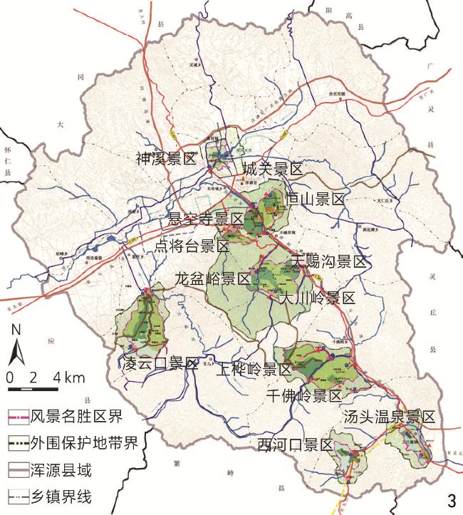
表1 北岳恒山风景区与外围保护地带面积Tab. 1 Area of Hengshan Mountain Scenic Area and the peripheral protected area |
| 片区名称 | 景区名称 | 面积/km2 | 外围保护地带 面积/km2 |
| 恒山-悬空寺 片区 | 恒山景区 | 22.73 | 30.45 |
| 悬空寺景区 | |||
| 点将台景区 | |||
| 城关景区 | |||
| 天赐沟片区 | 天赐沟景区 | 22.90 | 70.51 |
| 龙盆峪景区 | |||
| 大川岭景区 | |||
| 千佛岭片区 | 千佛岭景区 | 27.88 | 24.46 |
| 上桦岭景区 | |||
| 王庄堡片区 | 汤头温泉景区 | 15.96 | 25.77 |
| 西河口景区 | |||
| 凌云口片区 | 凌云口景区 | 25.74 | 13.86 |
| 神溪片区 | 神溪景区 | 7.17 | 17.20 |
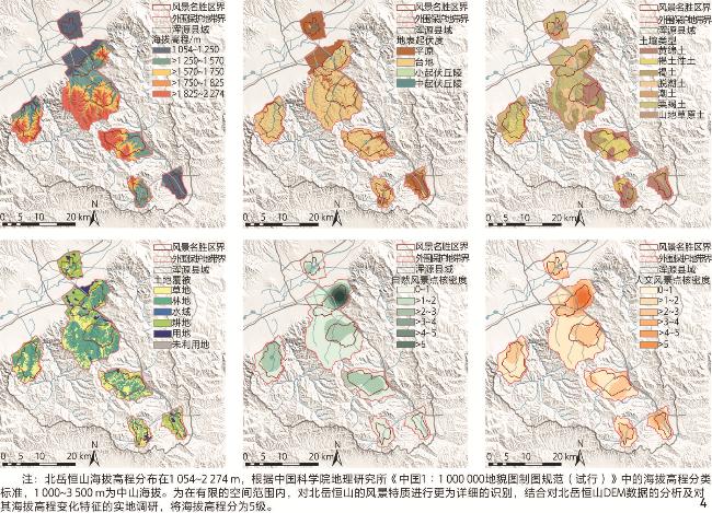
表2 北岳恒山风景特质评估要素分类Tab. 2 Classification of landscape character assessment elements of Hengshan Mountain Scenic Area |
| 要素类别 | 单要素类型 | 要素描述 |
| 自然要素 | 海拔高度 | 不同点位与海平面的相对高差 |
| 地表起伏度 | 不同区域地貌特征的概括 | |
| 植被 | 包括草地、林地等类型的植被 | |
| 水文 | 包括河流、水库等在内的水域范围 | |
| 土壤 | 不同区域土壤类型 | |
| 自然风景点核密度 | 典型自然风景点状资源空间分布密度 | |
| 人文要素 | 人文风景点核密度 | 各级文保单位及典型人文风景点状资源空间分布密度 |
| 建设用地 | 主要包括城乡、居民点聚落分布区域 |
表3 北岳恒山风景名胜区审美价值评估因子分类分级Tab. 3 Classification and grading of aesthetic value assessment factors of Hengshan Mountain Scenic Area |
| 综合评价层 | 项目评价层 | 因子评价层 | 评价标准 | 评级 |
| 自然环境 本底 | 植被 | 植被覆盖指数 | >0.8~1.0 | 5 |
| >0.6~0.8 | 4 | |||
| >0.4~0.6 | 3 | |||
| >0.2~0.4 | 2 | |||
| 0~0.2 | 1 | |||
| 山体 | 山体坡度/° | >80~100 | 5 | |
| >55~80 | 4 | |||
| >30~55 | 3 | |||
| >15~30 | 2 | |||
| 0~15 | 1 | |||
| 水体 | 水体缓冲区/m | 0~10 | 5 | |
| >10~20 | 4 | |||
| >20~50 | 3 | |||
| >50~100 | 2 | |||
| >100 | 1 | |||
| 自然人文风景点 | 视觉敏感度 (视距区间)/m | 0~100 | 5 | |
| >100~300 | 4 | |||
| >300~600 | 3 | |||
| >600~800 | 2 | |||
| >800 | 1 | |||
| 特色性 | 高 | 5 | ||
| 较高 | 4 | |||
| 中 | 3 | |||
| 较低 | 2 | |||
| 低 | 1 | |||
| 美景度 | 高 | 5 | ||
| 较高 | 4 | |||
| 中 | 3 | |||
| 较低 | 2 | |||
| 低 | 1 | |||
表4 北岳恒山不同保护范围内审美价值区域面积比例Tab. 4 Proportion of aesthetic value zones within different protected areas of Hengshan Mountain Scenic Area |
| 审美价值分级 | 研究范围 | 风景名胜区核心区域 | 外围保护地带范围 | |||||
| 面积/km2 | 比例/% | 面积/km2 | 比例/% | 面积/km2 | 比例/% | |||
| 高审美价值区域 | 56.00 | 18.38 | 23.77 | 19.42 | 32.23 | 17.68 | ||
| 较高审美价值区域 | 50.33 | 16.52 | 24.56 | 20.07 | 25.77 | 14.14 | ||
| 中审美价值区域 | 64.22 | 21.08 | 22.07 | 18.03 | 42.15 | 23.13 | ||
| 较低审美价值区域 | 67.74 | 22.24 | 24.94 | 20.38 | 42.80 | 23.48 | ||
| 低审美价值区域 | 66.34 | 21.78 | 27.04 | 22.10 | 39.30 | 21.56 | ||
| [1] |
孟兆祯. 中国风景名胜区的特色[J]. 中国园林, 2019, 35(3): 5-8.
MENG Z Z. The Characteristics of Scenic and Historic Areas of China[J]. Chinese Landscape Architecture, 2019, 35(3): 5-8.
|
| [2] |
陈耀华, 陈远笛. 风景名胜区的历史功能与当代使命[J]. 中国园林, 2019, 35(3): 16-20.
CHEN Y H, CHEN Y D. Historical Function and Contemporary Mission of Scenic and Historic Areas[J]. Chinese Landscape Architecture, 2019, 35(3): 16-20.
|
| [3] |
新华社.中共中央办公厅 国务院办公厅印发《关于建立以国家公园为主体的自然保护地体系的指导意见》[EB/OL].(2019-06-26)[2022-01-27]. https://www.gov.cn/zhengce/2019-06/26/content_5403497.htm.
The Xinhua News Agency. Guiding Opinions on Establishing a Nature Reserve System with National Parks as the Main Body Printed and Distributed by General Office, CPC Central Committee, General Office of the State Council of the People’s Republic of China[EB/OL]. (2019-06-26)[2022-01-27]. https://www.gov.cn/zhengce/2019-06/26/content_5403497.htm.
|
| [4] |
彭茜, 金云峰. 自然保护地体系、国家公园、风景名胜区规划编制技术与整合优化方法: 基于政策指引下的国土景观治理[J]. 城乡规划, 2023(6): 81-90.
PENG Q, JIN Y F. Planning Compilation Techniques and Integrated Optimization Methods of Natural Protected Area System, National Park and Scenic Spot: Based on Landscaping Governance Under Policy Guidelines[J]. Urban & Rural Planning, 2023(6): 81-90.
|
| [5] |
中国风景名胜区协会.自然资源部、国家林业和草原局近期多次明确“风景名胜区体系整体保留”[EB/OL].(2020-08-26)[2025-04-11]. http://www.china-npa.org/info/2938.jspx.
China Association of National Parks and Scenic Sites. The Ministry of Natural Resources of the People’s Republic of China and the National Forestry and Grassland Administration Have Recently Repeatedly Clarified the Overall Preservation of the Scenic Sites System[EB/OL].(2020-08-26)[2025-04-11]. http://www.china-npa.org/info/2938.jspx.
|
| [6] |
李金路. 天地一脉, 守正创新: 中国风景名胜区40年回顾展望[J]. 中国园林, 2024, 40(2): 6-10.
LI J L. Integrating Heaven and Earth, and Inheriting and Innovating: Retrospect and Prospect of the 40 Years of the Scenic and Historic Area System of China[J]. Chinese Landscape Architecture, 2024, 40(2): 6-10.
|
| [7] |
傅舒兰, 潘丁琳. 中国近代风景区制度的形成及其特征[J]. 风景园林, 2022, 29(4): 32-39.
FU S L, PAN D L. The Formation and Characteristics of Modern Scenic Zone System in China[J]. Landscape Architecture, 2022, 29(4): 32-39.
|
| [8] |
国务院.风景名胜区条例(2016修订)[EB/OL].(2016-02-06) [2024-02-22]. https://www.gov.cn/gongbao/content/2016/content_5139422.htm.
The State Council. Regulations on Scenic and Historic Areas (Revised in 2016)[EB/OL]. (2016-02-06)[2024-02-22]. https://www.gov.cn/gongbao/content/2016/content_5139422.htm.
|
| [9] |
李金路. 中国名山风景区的演化[J]. 风景园林, 2020, 27(4): 114-117.
LI J L. Evolution of Famous Mountain Resort in China[J]. Landscape Architecture, 2020, 27(4): 114-117.
|
| [10] |
孙晓雨, 杨金明, 张家豪, 等. 五台山风景名胜区土地利用变化及其对生境质量的影响[J]. 自然保护地, 2024, 4(2): 124-140.
SUN X Y, YANG J M, ZHANG J H, et al. Impact of Land Use Change on Habitat Quality in Mount Wutai Scenic Area[J]. Natural Protected Areas, 2024, 4(2): 124-140.
|
| [11] |
王向荣. 从山岳到风景名胜[J]. 中国园林, 2024, 40(2): 2-3.
WANG X R. From Mountains to Scenic and Historic Sites[J]. Chinese Landscape Architecture, 2024, 40(2): 2-3.
|
| [12] |
张司晗, 高琪, 刘晓明. 徐霞客风景审美评价思想和方法: 以雁荡山风景名胜区为例[J]. 中国城市林业, 2020, 18(3): 110-115.
ZHANG S H, GAO Q, LIU X M. Landscape Aesthetic Evaluation Thoughts and Methods of Xu Xiake: A Case Study of Yandang Mountain Scenic Spot[J]. Journal of Chinese Urban Forestry, 2020, 18(3): 110-115.
|
| [13] |
尹伊丹.基于SD法的鞍山千山风景区典型景观美感评价研究[D].沈阳: 沈阳建筑大学, 2020.
YIN Y D. A Study on the Aesthetic Evaluation of Typical Landscape in Qianshan Scenic Spot of Anshan Based on SD Method[D]. Shenyang: Shenyang Jianzhu University, 2020.
|
| [14] |
刘红纯, 邓武功, 王忠杰, 等. 风景名胜区总体规划编制的新形势与变革趋向探讨[J]. 风景园林, 2022, 29(12): 60-64.
LIU H C, DENG W G, WANG Z J, et al. Discussion on New Situation and Reform Trends in Formulating Master Planning of Scenic and Historic Areas[J]. Landscape Architecture, 2022, 29(12): 60-64.
|
| [15] |
苑竟达, 高曈曦, 刘楠, 等. 面向区域自然保护地整合优化的风景特质评价: 以青海省湟水谷地为例[J]. 风景园林, 2022, 29(1): 88-94.
YUAN J D, GAO T X, LIU N, et al. Landscape Character Assessment for the Integration and Optimization of Regional Protected Areas: A Case Study of the Huangshui Valley in Qinghai Province[J]. Landscape Architecture, 2022, 29(1): 88-94.
|
| [16] |
SWANWICK C. Landscape Character Assessment Guidance for England and Scotland[R]. Cheltenham: The Countryside Agency, 2002.
|
| [17] |
许晓青, 杨锐, 庄优波. 中国名山风景区审美价值识别框架研究[J]. 中国园林, 2016, 32(9): 63-70.
XU X Q, YANG R, ZHUANG Y B. Aesthetic Evaluation Framework Research of Chinese Famous Mountainous Scenic Sites[J]. Chinese Landscape Architecture, 2016, 32(9): 63-70.
|
| [18] |
STILLING S, BRAAE E. Relational Heritage: “Relational Character” in National Cultural Heritage Characterisation Tools[J]. Landscape Research, 2023, 48(7): 917-934.
|
| [19] |
杨叠川, 高翅. 解析欧洲多尺度风景特质识别的5项议题[J]. 风景园林, 2024, 31(1): 14-22.
YANG D C, GAO C. Analysis of Five Topics in Multi-scale Identification of Landscape Characters in Europe[J]. Landscape Architecture, 2024, 31(1): 14-22.
|
| [20] |
林轶南. 英国景观特征评估体系与我国风景名胜区评价体系的比较研究[J]. 风景园林, 2012, 19(1): 104-108.
LIN Y N. Comparative Study on England and Scotland’s Landscape Character Assessment System and the Evaluation System for the National Parks of China[J]. Landscape Architecture, 2012, 19(1): 104-108.
|
| [21] |
鲍梓婷, 蒋定哲, 周剑云, 等. 基于景观特征评估划定国土尺度景观规划管理的空间单元[J]. 中国园林, 2023, 39(3): 46-52.
BAO Z T, JIANG D Z, ZHOU J Y, et al. Delineation of Spatial Units for Landscape Planning and Management Based on Landscape Character Assessment (LCA) on Territorial Scale[J]. Chinese Landscape Architecture, 2023, 39(3): 46-52.
|
| [22] |
BRABYN L. Classifying Landscape Character[J]. Landscape Research, 2009, 34(3): 299-321.
|
| [23] |
孙乔昀, 张玉钧. 自然区域景观特征识别及其价值评估: 以青海湖流域为例[J]. 中国园林, 2020, 36(9): 76-81.
SUN Q Y, ZHANG Y J. Landscape Character Identification and Its Value Assessment in Natural Areas: A Case Study of Qinghai Lake Basin[J]. Chinese Landscape Architecture, 2020, 36(9): 76-81.
|
| [24] |
贺鼎, 卢丽娜, 王晶, 等. 大尺度线性遗产区域景观特征识别: 以北京长城文化带为例[J]. 风景园林, 2022, 29(9): 99-106.
HE D, LU L N, WANG J, et al. Landscape Character Identification in Large-Scale Linear Heritage Areas: A Case Study of Beijing Great Wall Cultural Belt[J]. Landscape Architecture, 2022, 29(9): 99-106.
|
| [25] |
张继力, 赵烨, 高翅. 山西省太原市晋源区乡村风景特质识别[J]. 风景园林, 2023, 30(2): 123-130.
ZHANG J L, ZHAO Y, GAO C. Identification of Rural Landscape Character in Jinyuan District, Taiyuan City, Shanxi Province[J]. Landscape Architecture, 2023, 30(2): 123-130.
|
| [26] |
龚苑红, 叶宗达, 吴静, 等. 游憩导向下喀斯特景观特征评估及空间格局构建[J]. 中国园林, 2023, 39(8): 102-107.
GONG Y H, YE Z D, WU J, et al. Recreation-Oriented Karst Landscape Feature Assessment and Spatial Pattern Construction[J]. Chinese Landscape Architecture, 2023, 39(8): 102-107.
|
| [27] |
YANG D, GAO C, LI L, et al. Multi-scaled Identification of Landscape Character Types and Areas in Lushan National Park and Its Fringes, China[J]. Landscape and Urban Planning, 2020, 201: 103844
|
| [28] |
张天骋, 高翅. 武当山风景名胜区五龙宫景区风景特质识别研究[J]. 中国园林, 2019, 35(2): 54-58.
ZHANG T C, GAO C. The Landscape Character Identification Research in Wulong Zone of Wudang Famous Scenic Area[J]. Chinese Landscape Architecture, 2019, 35(2): 54-58.
|
| [29] |
赵烨, 赵怡钧, 刘心宇, 等. 时空完整性视野下山岳风景遗产的保护方法: 以泰山为例[J]. 风景园林, 2023, 30(12): 86-92.
ZHAO Y, ZHAO Y J, LIU X Y, et al. Conservation Approach for Mountain Landscape Heritage from the Perspective of Spatial and Temporal Integrity: A Case Study of Mount Tai[J]. Landscape Architecture, 2023, 30(12): 86-92.
|
| [30] |
Hong Kong Development Bureau Planning Department. Landscape Value Mapping of Hong Kong: Final Report[R/OL].(2005)[2024-02-22]. https://www.pland.gov.hk/studies/landscape/landscape_final/index.html.
|
| [31] |
YANG C, SIM J, LAWSON G. Deciphering Historic Landscapes: A Case Study of Slender West Lake in Yangzhou, China[J]. Landscape Research, 2016, 41(1): 95-112.
|
| [32] |
郑华敏, 熊居华, 郑郁善. 武夷山风景名胜区景观美学评价及感知差异研究[J]. 农学学报, 2012, 2(10): 32-36.
ZHENG H M, XIONG J H, ZHENG Y S. Landscape Aesthetic Assessment and Perception Difference of Wuyishan Scenery District[J]. Journal of Agriculture, 2012, 2(10): 32-36.
|
| [33] |
李楠, 邵思远, 陈娇娇, 等. 蜀南竹海风景名胜区竹林美学感知对景观满意度的影响[J]. 自然保护地, 2023, 3(3): 123-132.
LI N, SHAO S Y, CHEN J J, et al. Influence of Bamboo Forest Aesthetic Perception on Landscape Satisfaction: A Case Study of the Southern Sichuan Bamboo Sea[J]. Natural Protected Areas, 2023, 3(3): 123-132.
|
| [34] |
姜辽, 余昊坤, 欧阳红. 审美影响自然旅游地亲环境行为研究[J]. 特区经济, 2024(10): 118-121.
JIANG L, YU H K, OUYANG H. Aesthetic Influence on the Environmental Behavior in Natural Tourist Areas[J]. Special Zone Economy, 2024(10): 118-121.
|
| [35] |
孙佼佼, 吕兴洋. 基于旅游审美哲学的艺旅融合: 理论逻辑与研究框架[J]. 旅游学刊, 2024, 39(9): 106-116.
SUN J J, LYU X Y. The Art-Tourism Integration Based on Tourism Aesthetic Philosophy: Theoretical Logic and Research Framework[J]. Tourism Tribune, 2024, 39(9): 106-116.
|
| [36] |
孙薇.景观人类学视角下甘肃省河西走廊旅游形象提升研究[D].兰州: 西北师范大学, 2024.
SUN W. Landscape Anthropology Research on the Promotion of Tourism Image in the Hexi Corridor[D]. Lanzhou: Northwest Normal University, 2024.
|
| [37] |
CHEN C H. A Novel Multi-criteria Decision-Making Model for Building Material Supplier Selection Based on Entropy-AHP Weighted TOPSIS[J]. Entropy, 2020, 22(2): 259
|
| [38] |
SHIH H S, SHYUR H J, LEE E S. An Extension of TOPSIS for Group Decision Making[J]. Mathematical and Computer Modelling, 2007, 45(7/8): 801-813.
|
| [39] |
国家质量监督检验检疫总局, 中国国家标准化管理委员会.风景名胜区管理通用标准: GB/T 34335—2017[S].北京: 中国标准出版社, 2017.
General Administration of Quality Supervision, Inspection and Quarantine of the People’s Republic of China, Standardization Administration of the People’s Republic of China. General Standard for Management of Scenic and Historic Areas: GB/T 34335−2017[S]. Beijing: Standards Press of China, 2017.
|
| [40] |
住房和城乡建设部.风景名胜区总体规划标准: GB/T 50298—2018[S].北京: 中国建筑工业出版社, 2018.
Ministry of Housing and Urban-Rural Development of the People’s Republic of China. Standard for Scenic and Historic Area General Planning: GB/T 50298−2018[S]. Beijing: China Architecture & Building Press, 2018.
|
| [41] |
王晓俊. 美国风景资源管理系统及其方法[J]. 自然资源学报, 1993, 8(4): 371-380.
WANG X J. The Scenery Resource Management System of the USA and Its Method[J]. Journal of Natural Resources, 1993, 8(4): 371-380.
|
| [42] |
DANIEL T C, BOSTER R S. Measuring Landscape Esthetics: The Scenic Beauty Estimation Method[M]. Fort Collins: Department of Agriculture, 1976.
|
/
| 〈 |
|
〉 |