
Promoting the Integration of Public Perspective into Urban Design Decision-Making Based on Crowdsourced Visual Perception Method
|
HUANG Lu is a Ph.D. graduate in the School of Environment and Society, Institute of Science Tokyo. His research focuses on application of artificial intelligence and big data, urban computing, and spatial statistics |
|
(JPN) OKI Takuya, D.Eng., is an associate professor and doctoral supervisor in the School of Environment and Society, Institute of Science Tokyo, and head of the OKI Lab. His research focuses on application of artificial intelligence and big data |
Received date: 2024-12-05
Revised date: 2025-03-19
Online published: 2025-12-10
Copyright
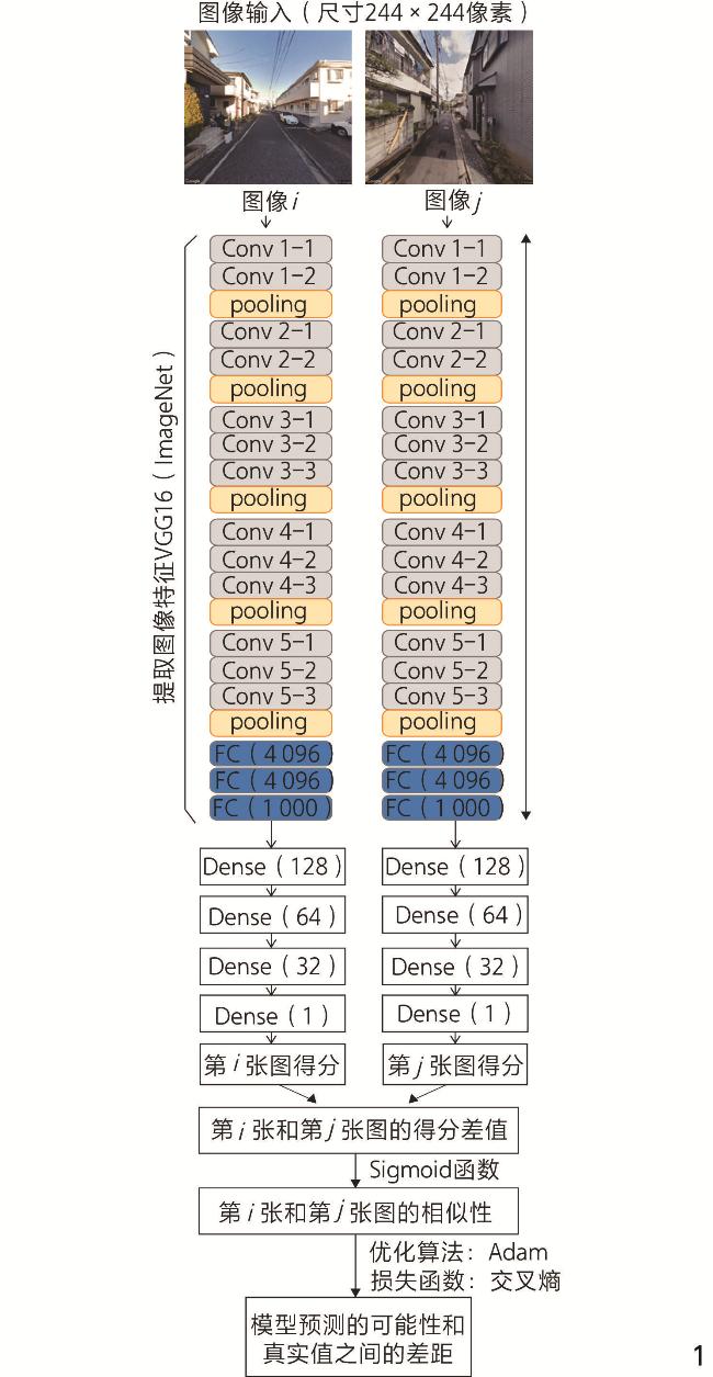
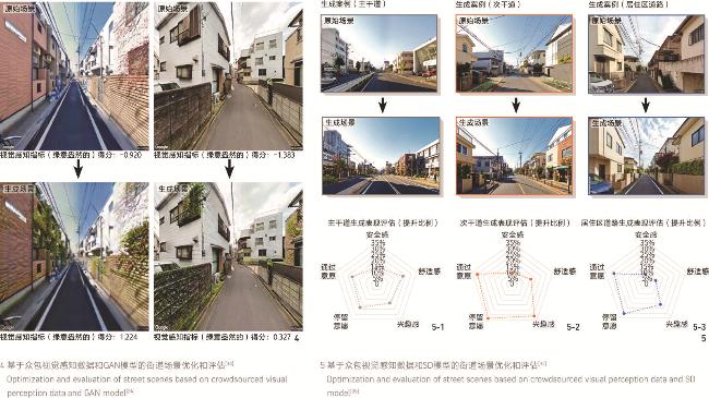
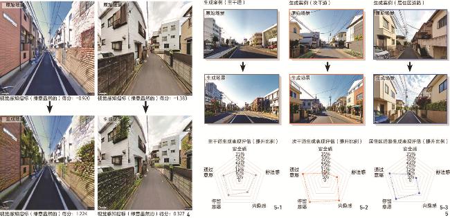
[Objective] Cities, as the core carriers of human civilization, have spatial forms and physical environments that profoundly affect the quality of residents’ life and well-being. In micro-scale urban settings — such as streets and squares closely tied to daily life — interactions between people and urban spaces are most direct and frequent, with design quality directly determining residents’ comfort and convenience. Urban design, as a key practice in shaping these spaces, has evolved into a human-centered, participatory process of placemaking. However, in practice, time and cost constraints often lead decisions to overly rely on professional judgment, making it challenging to fully reflect public needs. Urban perception captures the public’s preferences for specific urban environments and their experiential feedback on spatial demands. Rooted in environmental psychology, this concept views human perception as a vital link in human-environment interactions, bridging spatial design and human experience while playing a central role in shaping urban environments. Among sensory modalities, visual perception stands out as the dominant dimension due to its primacy, making it a core focus of urban perception studies. Examining urban perception reveals authentic public needs — though lacking professional design expertise to propose specific solutions, the public’s sensory experiences and perceptual feedback effectively highlight real demands, providing critical input for design decisions. Thus, understanding and integrating public urban perception not only enhances design responsiveness to user needs but also fosters a harmonious balance of functional efficiency and humanistic care. Crowdsourced visual perception data and analysis methods, with their advantages of efficiency, broad representativeness, and low cost, have become key methodological tools in urban built environment research. However, existing research has yet to systematically explore how these methods effectively facilitate the integration of public perspectives into urban design decision-making, leaving their pathways and methodological efficacy in need of further refinement and synthesis. This research aims to dissect the pathways and efficacy features of crowdsourced visual perception methods, systematically uncovering the theoretical logic and mechanisms by which they promote public involvement in urban design decisions, thereby providing a scientifically robust and practical methodological foundation for human-centered urban design practices. [Methods] The research employs a case study approach, analyzing multiple urban research papers focused on Tokyo, Japan, that utilize crowdsourced visual perception methods. It systematically investigates how these methods, across key urban design decision-making stages — data collection, data analysis, and scheme generation — facilitate the deep integration of public perspectives into design decisions through specific pathways and mechanisms. The study particularly emphasizes micro-scale urban design. [Results] In the data collection phase, perception inference models trained with crowdsourced visual perception data and deep learning efficiently compute and evaluate perceptions of micro-scale urban scenes, offering designers an automated, low-cost means to gain insights into public perspectives early in a project. This approach addresses the limitations of traditional methods in data coverage and cost, significantly enhancing the breadth and representativeness of public perspectives in design decisions. From the perspective of integration, crowdsourcing breaks the traditional top-down data acquisition barrier, enabling ordinary citizens to indirectly contribute to the informational foundation of urban design by sharing individual perceptions. This shift not only increases data diversity and inclusivity but also empowers the public to express needs and preferences in the early stages of design decision-making. In the data analysis phase, statistical methods establish quantitative models linking built environment factors with visual perception evaluations, uncovering the interaction mechanisms between public preferences and built environment elements. These methods identify key factors significantly affecting visual perception and determine optimal parameter ranges for design interventions via regression analysis, providing a scientific basis for formulating design strategies and goals. Notably, nonlinear analysis methods capture complex relationships with greater precision. In the scheme generation phase, integrating crowdsourced perception data with generative AI transforms public perceptual preferences into intuitive, visualized design language, introducing a novel human-machine collaboration approach to urban design decision-making. The visualized outputs of AI-generated schemes offer a transparent and comprehensible negotiation basis for subsequent decisions, facilitating stakeholder interpretation and participation. Within this technology, the Stable Diffusion (SD) model outperforms GAN in generation quality, diversity, and flexibility. [Conclusion] The research uses visual perception as a lens to integrate public perspectives, exploring the role of crowdsourced visual perception in micro-scale urban design decision-making through detailed case studies. It systematically examines the pathways and mechanisms by which this approach embeds public input, highlighting its applicability, technical implementation, and inherent limitations. The findings offer a robust framework for incorporating public perspectives into micro-scale urban design decisions while laying a theoretical groundwork to advance the scientific rigor and inclusivity of the design decision-making process.
Lu HUANG , Takuya (JPN) OKI . Promoting the Integration of Public Perspective into Urban Design Decision-Making Based on Crowdsourced Visual Perception Method[J]. Landscape Architecture, 2025 , 32(5) : 22 -28 . DOI: 10.3724/j.fjyl.LA20240101
| [1] |
甄峰, 席广亮, 张姗琪, 等. 智慧城市人地系统理论框架与科学问题[J]. 自然资源学报, 2023, 38(9): 2187-2200.
ZHEN F, XI G L, ZHANG S Q, et al. Theoretical Framework and Scientific Problems of Smart City Man-Land System[J]. Journal of Natural Resources, 2023, 38(9): 2187-2200.
|
| [2] |
SUN Z, BELL S, SCOTT I, et al. Everyday Use of Urban Street Spaces: The Spatio-Temporal Relations Between Pedestrians and Street Vendors: A Case Study in Yuncheng, China[J]. Landscape Research, 2020, 45(3): 292-309.
|
| [3] |
PANAGOULIA E. Human-Centered Approaches in Urban Analytics and Placemaking[J]. Sustainability in Urban Planning and Design, 2020: 149.
|
| [4] |
WANG Y, LIN Y. Public Participation in Urban Design with Augmented Reality Technology Based on Indicator Evaluation[J]. Frontiers in Virtual Reality, 2023, 4: 1071355
|
| [5] |
WRONKOWSKI A. Exploring User Needs in Urban Plazas: An Empirical Mixed-Method Analysis Bulletin of Geography: Socio-economic Series, 2024(65): 67-84.
|
| [6] |
NASAR J L. Perception, Cognition, and Evaluation of Urban Places[M]. Boston: Springer, 1989: 31-56.
|
| [7] |
MILIAS V, SHARIFI NOORIAN S, BOZZON A, et al. Is It Safe to Be Attractive? Disentangling the Influence of Streetscape Features on the Perceived Safety and Attractiveness of City Streets[J]. AGILE: GIScience Series, 2023, 4: 8
|
| [8] |
HUANG A S, LIN Y J. The Effect of Landscape Colour, Complexity and Preference on Viewing Behaviour[J]. Landscape Research, 2020, 45(2): 214-227.
|
| [9] |
EWING R, HANDY S. Measuring the Unmeasurable: Urban Design Qualities Related to Walkability[J]. Journal of Urban Design, 2009, 14(1): 65-84.
|
| [10] |
XU X, QIU W, LI W, et al. Associations Between Street-View Perceptions and Housing Prices: Subjective Vs. Objective Measures Using Computer Vision and Machine Learning Techniques[J]. Remote Sensing, 2022, 14(4): 891
|
| [11] |
KRUSE J, KANG Y, LIU Y N, et al. Places for Play: Understanding Human Perception of Playability in Cities Using Street View Images and Deep Learning[J]. Computers, Environment and Urban Systems, 2021, 90: 101693
|
| [12] |
NAIK N, PHILIPOOM J, RASKAR R, et al. Streetscore: Predicting the Perceived Safety of One Million Streetscapes[C]//IEEE Xplore. 2014 IEEE Conference on Computer Vision and Pattern Recognition Workshops. Columbus: CVPR, 2014: 793-799.
|
| [13] |
DUBEY A, NAIK N, PARIKH D, et al. Deep Learning the City: Quantifying Urban Perception at a Global Scale[C]//LEIBE B. Computer Vision: ECCV 2016. Cham: Springer International Publishing, 2016: 196-212.
|
| [14] |
MOORE G, CROXFORD B, ADAMS M, et al. Urban Environmental Quality: Perceptions and Measures in Three UK Cities[C]//MANDER U. WIT Transactions on Ecology and the Environment. Tallin: WIT Press, 2006: 785-794.
|
| [15] |
GRIEW P, HILLSDON M, FOSTER C, et al. Developing and Testing a Street Audit Tool Using Google Street View to Measure Environmental Supportiveness for Physical Activity[J]. The International Journal of Behavioral Nutrition and Physical Activity, 2013, 10: 103
|
| [16] |
ITO K, KANG Y, ZHANG Y, et al. Understanding Urban Perception with Visual Data: A Systematic Review[J]. Cities, 2024, 152: 105169
|
| [17] |
KELLY C M, WILSON J S, BAKER E A, et al. Using Google Street View to Audit the Built Environment: Inter-Rater Reliability Results[J]. Annals of Behavioral Medicine, 2013, 45(S1): 108-112.
|
| [18] |
HWANG J, SAMPSON R J. Divergent Pathways of Gentrification[J]. American Sociological Review, 2014, 79(4): 726-751.
|
| [19] |
QUERCIA D, O’HARE N K, CRAMER H. Aesthetic Capital: What Makes London Look Beautiful, Quiet, and Happy? [C]// FUSSELL S. Proceedings of the 17th ACM Conference on Computer Supported Cooperative Work & Social Computing. Baltimore: ACM, 2014: 945-955.
|
| [20] |
ORDONEZ V, BERG T L. Learning High-Level Judgments of Urban Perception[C]//FLEET D. Computer Vision: ECCV 2014. Cham: Springer International Publishing, 2014: 494-510.
|
| [21] |
ZHANG F, ZHOU B, LIU L, et al. Measuring Human Perceptions of a Large-Scale Urban Region Using Machine Learning[J]. Landscape and Urban Planning, 2018, 180: 148-160.
|
| [22] |
OKI T, KIZAWA S. Model for Evaluating Impression of Streets in Residential Areas Based on Image Big Data and a Large Questionnaire Survey[J]. Journal of Architecture and Planning, 2022, 87: 2102-2133.
|
| [23] |
OGAWA Y, OKI T, ZHAO C, et al. Evaluating the Subjective Perceptions of Streetscapes Using Street-View Images[J]. Landscape and Urban Planning, 2024, 247: 105073
|
| [24] |
IMADEGAWA Y, OKI T, OGAWA Y, et al. Predicting Impression Evaluation of Building Exterior Appearance Using Street Image Big Data and Deep Learning[C]//IEEE Xplore. 2023 IEEE International Conference on Big Data. Sorrento: IEEE, 2023: 1419-1428.
|
| [25] |
HUANG L, OKI T, MUTO S, et al. Unveiling the Non-linear Influence of Eye-Level Streetscape Factors on Walking Preference: Evidence from Tokyo[J]. ISPRS International Journal of Geo-Information, 2024, 13(4): 131
|
| [26] |
LIU Y, CHEN M, WANG M, et al. An Interpretable Machine Learning Framework for Measuring Urban Perceptions from Panoramic Street View Images[J]. iScience, 2023, 26(3): 106132
|
| [27] |
OKI T, OGAWA Y, ZHAO C. Urban Impressions Evaluation and Its Age and Gender Differences: Application of the Urban Impressions Evaluation Model[C]//GISA. Proceedings of the 30th Conference of Man-Environment Research Association. Okinawa: GISA, 2023.
|
| [28] |
HARADA K, OKI T. Modelling the Effects of Weather and Time of Day on People’s Subjective Evaluation of Street Impressions[C]//JSAI. Proceedings of the 37th Annual Conference of the Japanese Society for Artificial Intelligence. Kumamoto: JSAI, 2023.
|
| [29] |
ZHAO C, OGAWA Y, CHEN S, et al. Quantitative Land Price Analysis via Computer Vision from Street View Images[J]. Engineering Applications of Artificial Intelligence, 2023, 123: 106294
|
| [30] |
ZHANG F, FAN Z, KANG Y, et al. “Perception Bias”: Deciphering a Mismatch Between Urban Crime and Perception of Safety[J]. Landscape and Urban Planning, 2021, 207: 104003
|
| [31] |
HE J, ZHANG J, YAO Y, et al. Extracting Human Perceptions from Street View Images for Better Assessing Urban Renewal Potential[J]. Cities, 2023, 134: 104189
|
| [32] |
ZHAO C, OGAWA Y, CHEN S, et al. People Flow Trend Estimation Approach and Quantitative Explanation Based on the Scene Level Deep Learning of Street View Images[J]. Remote Sensing, 2023, 15(5): 1362
|
| [33] |
JOGLEKAR S, QUERCIA D, REDI M, et al. FaceLift: A Transparent Deep Learning Framework to Beautify Urban Scenes[J]. Royal Society Open Science, 2020, 7(1): 190987
|
| [34] |
YAMANAKA R, OKI T. Development of a Simulation Method Capable of Integratively Predicting Changes in Street Landscape Images and Impression Evaluation Values[C]// JSAI. Proceedings of the 36th Annual Conference of the Artificial Intelligence Society of Japan. Kyoto: JSAI, 2022.
|
| [35] |
HUANG L, OKI T. Enhancing People’s Walking Preferences in Street Design Through Generative Artificial Intelligence and Crowdsourcing Surveys: The Case of Tokyo[J]. Environment and Planning B: Urban Analytics and City Science, 2025: 23998083251327405.
|
| [36] |
RIJAL S. The Importance of Community Involvement in Public Management Planning and Decision-making Processes[J]. Journal of Contemporary Administration and Management (ADMAN), 2023, 1(2): 84-92.
|
| [37] |
GIFFORD R. Environmental Psychology Matters[J]. Annual Review of Psychology, 2014, 65: 541-579.
|
| [38] |
RYAN R L. The Social Landscape of Planning: Integrating Social and Perceptual Research with Spatial Planning Information[J]. Landscape and Urban Planning, 2011, 100(4): 361-363.
|
| [39] |
GOODSPEED R. The Role of Artificial Intelligence in Urban Planning[J]. Journal of the American Planning Association, 82(4), 318-319.
|
| [40] |
BRABHAM D C. Crowdsourcing in the Public Sector[M]. Washington, D.C.: Georgetown University Press, 2015.
|
| [41] |
MA L, CAO J. How Perceptions Mediate the Effects of the Built Environment on Travel Behavior?[J]. Transportation, 2019, 46(1): 175-197.
|
| [42] |
JIANG F, MA J, WEBSTER C J, et al. Generative Urban Design: A Systematic Review on Problem Formulation, Design Generation, and Decision-Making[J]. Progress in Planning, 2024, 180: 100795
|
| [43] |
GUPTA S. Agency, Trust, and Interpretability of Generative Adversarial Networks (GANs)[D]. Raleigh: North Carolina State University, 2021.
|
| [44] |
RITTEL H W J, WEBBER M M. Dilemmas in a General Theory of Planning[J]. Policy Sciences, 1973, 4(2): 155-169.
|
/
| 〈 |
|
〉 |