
Analysis of the Spatial Pattern of Military River Defense on the Ming Great Wall: A Case Study of the Shanxi Section of the Yellow River
|
WANG Tianlian is a Ph.D.candidate in the School of Architecture, Tianjin University, and a member in the Key Laboratory of Information Technology for the Inheritance of Architectural Cultural Heritage, Ministry of Culture and Tourism. Her research focus on cultural heritage preservation |
|
LI Zhe, Ph.D., is a professor in the School of Architecture, Tianjin University, and deputy director of the Key Laboratory of Information Technology for the Inheritance of Architectural Cultural Heritage, Ministry of Culture and Tourism. His research focus on cultural heritage preservation |
Received date: 2024-05-18
Revised date: 2024-11-22
Online published: 2025-12-07
Copyright
[Objective] River defence plays a vital role in the development of the Ming Great Wall’s military defence system. The spatial arrangement of river defence, represented by the Yellow River defence, embodies the ancient practice of adapting to local conditions, optimizing resource utilization, and transforming challenges into the guide of construction. This research takes river as a focal point to investigate the intricate relationship between the water system and military defence system. The analysis of the spatial pattern of river defense can improve the theoretical framework of the Great Wall defense system, thus fully integrating the multiple resource values of the Great Wall and the Yellow River.
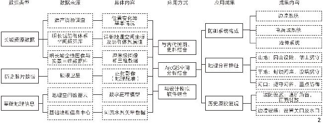
[Methods] The quantitative analysis is conducted using the ArcGIS geographic information platform, involving the review of historical documents, the field investigation of existing sites, the utilization of drones for low-altitude image data collection for purpose of generating 3D real scene model, and the integration of historical aerial films and other multi-source data.The specific methodology comprises two key components: Firstly, analyzing the constituent elements of the defense system of river defence space and summarizing their functional attributes based on the theoretical framework of the Ming Great Wall’s military defence; secondly, summarizing the spatial distribution characteristics of river defence elements by incorporating changes in geographic location, hydrology, environment, and other natural factors. Indicators such as elevation, slope, and distribution distance are extracted to analyze the spatial characteristics of river defense under varying conditions. Then, the spatial distribution characteristics of the defense system in different modes were quantified. Ultimately, historical aerial films and real 3D point cloud data are utilized to reproduce the original appearance of defence facilities at river defence nodes.
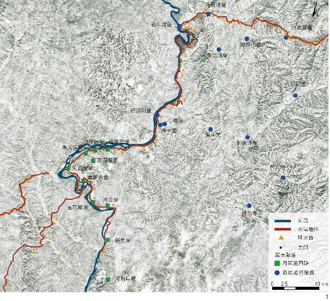
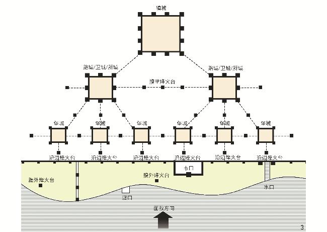
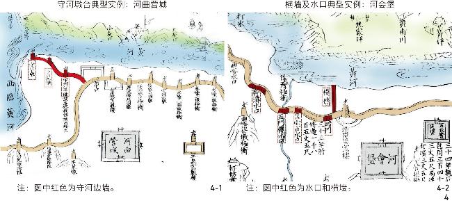
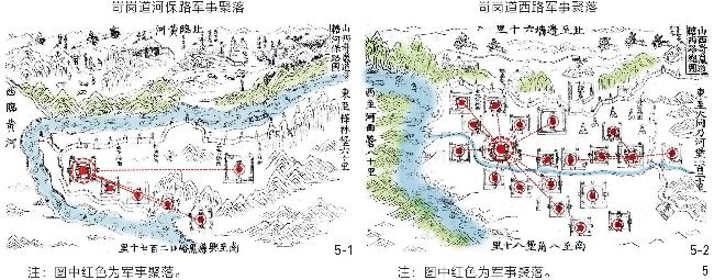
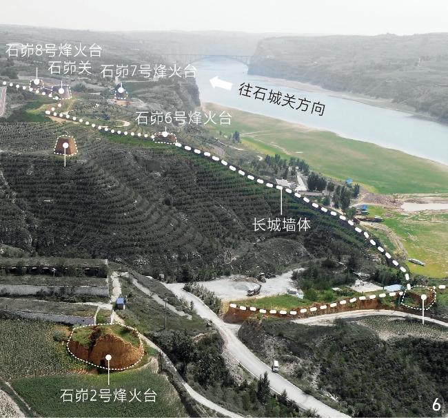
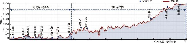
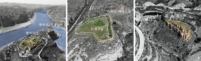
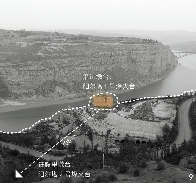
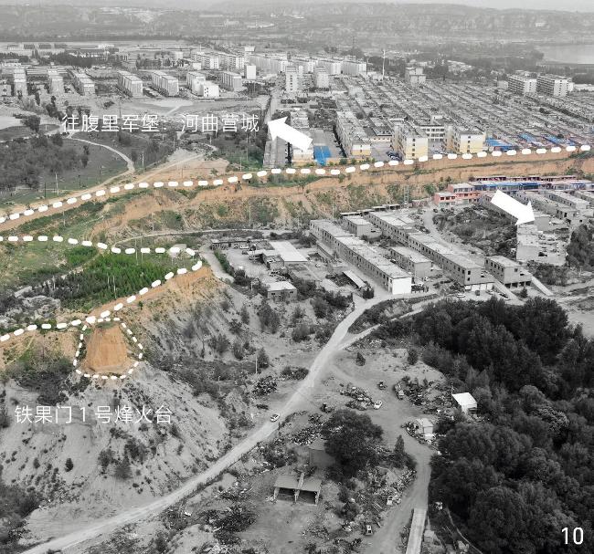
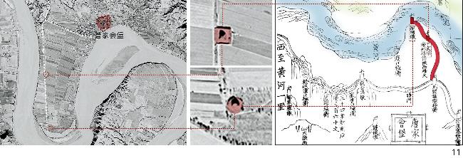
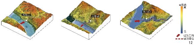
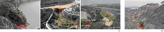
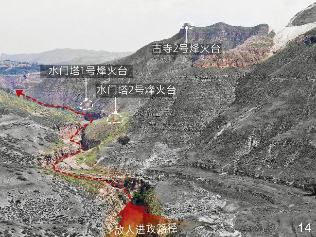
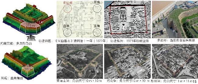
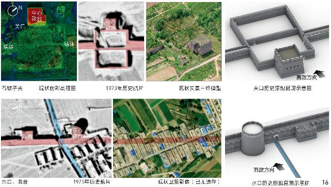
[Results] Research results are summarized as follows. 1) In terms of the composition of element systems, the military river defense space focuses on strengthening the construction of the border wall system, military settlement, and beacon transmission system within each subsystem of the Ming Great Wall defense system. These systems are combined through points and lines to form a tight defense network of “waterfront warning−border defense−information transmission−reinforcement and response−military command−logistics support” to jointly realize the construction of a military defense pattern in the river defense space. 2) In terms of spatial distribution and site selection, military defense facilities have formed three geographical spatial distribution patterns under the influence of river morphology and specific natural factors. Starting from Laoniuwan, the Yellow River in the research area runs from north to south through Louziying to Hequ, with its southernmost end reaching Shiti Pass. During this process, the Yellow River experiences changes in elevation from high to low and water velocity from fast to slow, forming a geographical spatial change pattern from a curved river valley to an accumulation of shoals. 3) In the development of node facilities, city defense facilities and border wall nodes are tailored to cater to the requirements of river defense. This includes expanding corner ramparts for frontal enemy protection and incorporating passes and water gates on border walls to manage water flow. Using data extracted from historical aerial photos and 3D Real Scene point cloud, the original historical original appearance of Hequying City (a river defense node) and its border walls is restored.
[Conclusion] Driven by the intricate river water environment and military defense demands, a layered military defense network has emerged within the spatial pattern of river defense, and a comprehensive defense layout has been established by fully leveraging the natural terrain. Research results underscore the intrinsic relationship between the Great Wall’s military defense system and the natural river elements, which can promote the value research and comprehensive preservation of the military river defense space in Ming Dynasty. This research is envisioned to interconnect the Yellow River and the Great Wall National Cultural Park networks through river systems, thus contributing to the establishment of a comprehensive national cultural park system and the creation of significant symbols of Chinese culture.
Tianlian WANG , Zhe LI . Analysis of the Spatial Pattern of Military River Defense on the Ming Great Wall: A Case Study of the Shanxi Section of the Yellow River[J]. Landscape Architecture, 2025 , 32(1) : 124 -132 . DOI: 10.3724/j.fjyl.202405180272
表1 自然地理指标及类型占比Tab. 1 Quantification and type proportion of physical geography indicators |
| 类型 | 占比/% | |||||
| 指标 | 分级 | 山地(岢岚道西路) | 平地(岢岚道河保路) | |||
| 军事聚落 | 烽燧 | 军事聚落 | 烽燧 | |||
| 高程/m | 500~1 000 | 12.5 | 15.6 | 96.2 | 87.6 | |
| >1 000~1 500 | 72.9 | 69.4 | 4.8 | 12.4 | ||
| >1 500~2 000 | 12.1 | 13.6 | 0 | 0 | ||
| >2 000 | 2.5 | 1.4 | 0 | 0 | ||
| 坡度/° | 0~3 | 33.3 | 48.4 | 63.6 | 59.4 | |
| >3~6 | 54.2 | 42.6 | 27.3 | 38.5 | ||
| >6~9 | 8.3 | 9.0 | 9.1 | 2.1 | ||
| >9 | 4.2 | 0 | 0 | 0 | ||
| 与河流距离/m | 0~500 | 13.5 | 23.6 | 38.5 | 43.2 | |
| >500~1 000 | 38.4 | 42.3 | 49.2 | 39.8 | ||
| >1 000~1 500 | 40.7 | 18.3 | 12.3 | 14.8 | ||
| >2 000 | 7.4 | 15.8 | 0 | 2.2 | ||
| 分布间距/m | 0~2 000 | 13.4 | 93.6 | 33.6 | 98.4 | |
| >2 000~5 000 | 16.4 | 6.4 | 48.5 | 1.6 | ||
| >5 000~10 000 | 68.4 | 0 | 15.4 | 0 | ||
| >10 000 | 1.8 | 0 | 2.5 | 0 | ||
| [1] |
曹迎春. 明长城宣大山西三镇军事防御聚落体系宏观系统关系研究[D]. 天津: 天津大学, 2015.
CAO Y C. Research on the Macro Systematic Relationship of Military Defense Settlements in the Xuan Da Shanxi Three Towns of the Ming Great Wall[D]. Tianjin: Tianjin University, 2015.
|
| [2] |
何宝善. 明实录长城史料[M]. 北京: 北京燕山出版社, 2014.
HE B S. Historical Materials of the Ming Chronicle Great Wall[M]. Beijing: Beijing Yanshan Publishing House, 2014.
|
| [3] |
卢承业. 道光偏关志[M].[出版地不详: 出版者不详],[1846]: 1559-1698.
LU C Y. Gazetteer of Pian Guan in the Daoguang Era[M].[S.l.: s.n.],[1846]: 1559-1698.
|
| [4] |
马雪芹. 明清黄河水患与下游地区的生态环境变迁[J]. 江海学刊, 2001 5): 128-133
MA X Q. Ecological and Environmental Changes in the Downstream Areas of the Yellow River During the Ming and Qing Dynasties[J]. Jianghai Academic Journal, 2001 5): 128-133.
|
| [5] |
邹逸麟. 明代治理黄运思想的变迁及其背景: 读明代三部治河书体会[J]. 陕西师范大学学报(哲学社会科学版), 2004, 33(5): 21-26
ZOU Y L. Evolution of the Ming Dynasty’s Conception of Administering Transportation on the Huanghe River and the Relative Background Accounts: The Author’s Impression from the Three Works on Harnessing the Huanghe River in the Ming Dynasty[J]. Journal of Shaanxi Normal University (Philosophy and Social Sciences Edition), 2004, 33(5): 21-26.
|
| [6] |
胡春宏, 陈建国, 孙雪岚, 等. 黄河下游河道健康状况评价与治理对策[J]. 水利学报, 2008, 39(10): 1189-1196
HU C H, CHEN J G, SUN X L, et al. Health Assessment of River Course in Lower Yellow River and Measures for Regulation[J]. Journal of Hydraulic Engineering, 2008, 39(10): 1189-1196
|
| [7] |
李严, 张玉坤, 李哲. 明长城防御体系与军事聚落研究[J]. 建筑学报, 2018 5): 69-75
LI Y, ZHANG Y K, LI Z. A Study of the Defense System and Military Settlements of the Ming Great Wall[J]. Architectural Journal, 2018 5): 69-75.
|
| [8] |
范熙晅, 张玉坤, 李严. 明长城军事防御体系规划布局机制研究[M]. 北京: 中国建筑工业出版社, 2019.
FAN X X, ZHANG Y K, LI Y. Study on the Planning and Layout Mechanism of the Military Defense System of the Ming Great Wall[M]. Beijing: China Architecture & Building Press, 2019.
|
| [9] |
曹迎春, 张玉坤. 明长城宣大山西三镇军事防御聚落体系宏观系统关系研究[M]. 北京: 中国建筑工业出版社, 2020.
CAO Y C, ZHANG Y K. Study on the Macro System Relationship of Military Defense Settlements in Three Towns in Shanxi Province of the Ming Great Wall[M]. Beijing: China Architecture & Building Press, 2020.
|
| [10] |
李严. 明长城“九边”重镇军事防御性聚落研究[D]. 天津: 天津大学, 2007.
LI Y. Study on the Military Defense Settlements of the “Nine Borders” of the Ming Great Wall[D]. Tianjin: Tianjin University, 2007.
|
| [11] |
张玉坤, 李严. 明长城九边重镇防御体系分布图说[J]. 华中建筑, 2005, 23(2): 116-119
ZHANG Y K, LI Y. Illustration on the Defense System Distribution of the Nine Important Defense Areas in the Great Wall of Ming Dynasty[J]. Huazhong Architecture, 2005, 23(2): 116-119.
|
| [12] |
张玉坤, 陈海燕, 董耀会. 中国长城志: 边镇堡寨关隘[M]. 南京: 江苏凤凰科学技术出版社, 2016.
ZHANG Y K, CHEN H Y, DONG Y H. The Great Wall of China: Border Towns, Fortresses, Gates[M]. Nanjing: Jiangsu Phoenix Science and Technology Press, 2016.
|
| [13] |
李严, 尚筱玥, 周雅琴. 明长城军事聚落地理景观模式[J]. 风景园林, 2023, 30(2): 97-104
LI Y, SHANG X Y, ZHOU Y Q. Geographical Landscape Model of Military Settlements Along the Ming Great Wall[J]. Landscape Architecture, 2023, 30(2): 97-104.
|
| [14] |
贺鼎, 吴海怡, 张杰. 沟峪单元视角下明长城古北路军防空间特征及其影响因素研究[J]. 新建筑, 2023 1): 152-158
HE D, WU H Y, ZHANG J. Research on the Spatial Characteristics and Influencing Factors of the Ming Great Wall Military Defense System in Gubei Divisions from the Perspective of Valley Units[J]. New Architecture, 2023 1): 152-158.
|
| [15] |
段诗乐, 林箐. 明长城宁夏镇军事聚落分布与选址研究[J]. 风景园林, 2021, 28(6): 107-113
DUAN S L, LIN Q. Research on the Distribution and Site Selection of Military Settlements of the Ming Great Wall in Ningxia Military Town[J]. Landscape Architecture, 2021, 28(6): 107-113.
|
| [16] |
杨时宁. 宣大山西三镇图说[M]. 台北: 中央图书馆, 1981.
YANG S N. Illustrations of the Three Towns in Shanxi[M]. Taipei: Central Library, 1981.
|
| [17] |
薄音湖, 王雄. 明代蒙古汉籍史料汇编(第二辑)[M]. 呼和浩特: 内蒙古大学出版社, 2006.
BO Y H, WANG X. Compilation of Mongolian and Han Documents of the Ming Dynasty (Volume 2)[M]. Hohhot: Inner Mongolia University Press, 2006.
|
| [18] |
王雄. 明代蒙古汉籍史料汇编: 徐日久·五边典则(卷一—卷十八, 第五辑)[M]. 呼和浩特: 内蒙古大学出版社, 2006.
WANG X. Compilation of Historical Materials on Mongolian Han Documents in the Ming Dynasty: Xu Rijiu, Five Border Regulations (Volumes 1-18, Volume 5)[M]. Hohhot: Inner Mongolia University Press, 2006.
|
| [19] |
陈仁锡. 无梦园初集[M].[出版地不详: 出版者不详],[1633].
CHEN R X. The First Episode of Dreamless Garden[M]. [S.l.: s.n.],[1633].
|
| [20] |
康丕扬. 三关图说[M].[出版地不详: 出版者不详],[1547].
KANG P Y. Illustrations of the Three Passes[M]. [S.l.: s.n.],[1547].
|
| [21] |
李维祯. 万历山西通志[M]. 北京: 中华书局, 2017.
LI W Z. Shanxi General Chronicles of Wanli[M]. Beijing: Zhonghua Book Company, 2017.
|
| [22] |
申欢欢. 明长城大同镇烽传系统研究[D]. 天津: 天津大学, 2023.
SHEN H H. Research on the Beacon Transmission System of the Great Wall in Datong Town[D]. Tianjin: Tianjin University, 2023.
|
| [23] |
李侃. 成化山西通志[M].[出版地不详: 出版者不详],[1457].
LI K. Chenghua Shanxi General Chronicles[M]. [S.l.: s.n.],[1457].
|
| [24] |
佚名. 保德州志[M]. 忻州: 山西人民出版社, 1990.
Anon. Baodezhou Records[M]. Xinzhou: Shanxi People's Publishing House, 1990.
|
| [25] |
汪楫. 崇祯长编卷27[M]. [出版地不详: 出版者不详], 1967.
WANG J. Volume 27 of Chongzhen's Compilation[M]. [S. l.: s.n.], 1967.
|
| [26] |
马云举. 同治河曲县志[M].[出版地不详: 出版者不详],[1650]: 28-36.
MA Y J. Tongzhi Hequ County Chronicles[M].[S.l.: s.n.],[1650]: 28-36.
|
| [27] |
周鉴. 金汤借箸[M]. [出版地不详: 出版者不详][1638].
ZHOU J. Jin Tang Borrowed Chopsticks[M]. [S.l.: s.n.],[1638].
|
| [28] |
茅元仪. 武备志·卷116·军资篇[M].[出版地不详: 出版者不详],[1621].
MAO Y Y. Wubei Zhi·Volume 116·Military Supplies[M]. [S.l.: s.n.],[1621].
|
| [29] |
李严, 张玉坤, 李哲. 长城的整体性研究与数字化实践[J]. 世界建筑, 2022 8): 16-21
LI Y, ZHANG Y K, LI Z. A Holistic Study and Digital Practice of the Great Wall[J]. World Architecture, 2022 8): 16-21.
|
/
| 〈 |
|
〉 |