
Integrated Framework and Technical Path for Multi-level Nested Assessment of Landscape Character
|
WANG Yuncai, Ph.D., is a tenured professor and doctoral supervisor in the College of Architecture and Urban Planning (CAUP), Tongji University, and an editorial board member of this journal. His research focuses on pattern language, and teaching, research and engineering practice of landscape ecological planning and design |
|
DONG Qizhen is a master student in the College of Architecture and Urban Planning (CAUP), Tongji University. Her research focuses on landscape ecological planning |
Received date: 2024-04-13
Revised date: 2024-11-13
Online published: 2025-12-07
Copyright
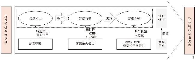
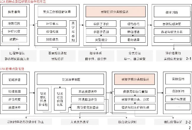
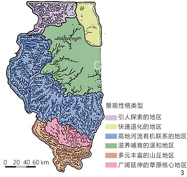
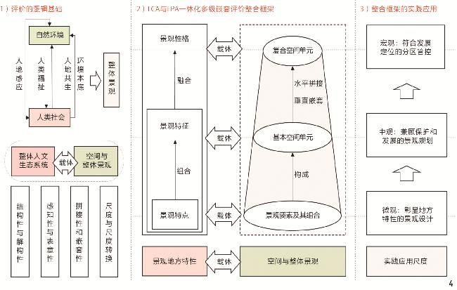
[Objective] The landscape character assessment system is an effective tool to help people understand the history and current status of landscapes. Its results are widely used in land decision-making and spatial planning control. Landscape character assessment (LCA) and landscape personality assessment (LPA) are two different perspectives and systems. LCA has a certain research and practical foundation, forming a relatively mature methodology system, emphasizing the characterization of the current status of landscape. In contrast, there is relatively little research and practice related to LPA, although attention has been paid to the trend of landscape changes. In addition, there is a nested relationship in terms of value implications, landscape spatial carrier, evaluation index system, and practical application of results, and there is a certain degree of complementarity between LPA and LCA. Integrating LCA and LPA and constructing a multi-level nested framework for landscape character assessment can sort out the multi-level relationships of landscape character representation, better meet practical needs at different scales, and help people comprehensively understand the past, present, and future of landscape.
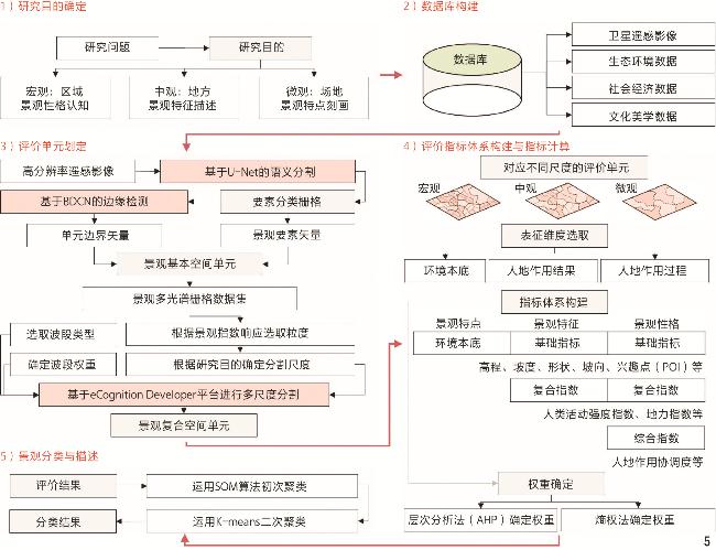
[Methods] Taking the landscape character assessment system as the research object, this research analyzes the concepts and connotations related to landscape character, and evaluates the shortcomings of existing LCA and LPA research and practice from the aspects of value dimension, indicator system, process characteristic, classification method, etc. There is considerable research and practical experience in the LCA research field, and scholars have also explored LPA. This research analyzes, evaluates, and horizontally compares relevant typical research and practical projects both domestically and internationally. The overall landscape carries the overall humanistic ecosystem, whose structurality and decomposability determine that landscape space is a complex composed of multiple relatively independent spaces, concatenation and nesting determine the multi-level nesting of the overall landscape space, and perceptibility and symbolism determine that identifying the characteristics of a landscape is a way to recognize the unique value of the landscape. Based on existing research content, the research summarizes the overall characteristics and future development trends of the two assessment methods, analyzes the differences and underlying connections between them, and explores possible integration methods for them.
[Results] LCA can describe what a landscape is, while LPA can explore why it is. Comparing the methodology of LCA with that of LPA, LPA and LCA have certain complementarity in research perspective, indicator system, classification method, and other aspects. LCA focuses on the objective description of elements and their combination level features, which can depict local landscape differences and is supported by quantitative analysis techniques; LPA focuses on the comprehensive effects in the dynamic process of resource combination, which can characterize the value and personalized characteristics of the overall landscape, but lacks quantitative classification techniques. Landscape personality is formed by highly condensed landscape character with inherent attributes that are perceived by humans, and LCA is the foundation of LPA formation. LCA and LPA have certain complementarity in different stages of landscape character assessment, and are two sets of local character representation ideas suitable for different scenes in the landscape character assessment system. The integration of the two can help optimize the landscape character assessment system in both theory and practice. Based on the overall characteristics of landscape and the nesting of landscape spatial units, integrating the perspectives and systems of LCA and LPA, a multi-level nested framework for landscape character assessment is proposed as a reference for understanding the multi-scale local characteristics and spatial systems of landscape. By combining multi-scale segmentation and spatial clustering techniques of deep learning, a technical path for multi-level nested landscape character assessment is constructed as a new idea for characterizing the local characteristics of landscape at multiple scales.
[Conclusion] In the process of developing landscape character assessment systems, there have been numerous methodological systems. The multi-level nested assessment framework and technical path integrating LCA and LPA can accurately grasp the local characteristics of landscape through quantitative assessment and spatial mapping using artificial intelligence technology at different scales of practical needs. This framework serves as a comprehensive framework in the landscape character assessment system, providing a holistic perspective for exploring the unique value of landscape. In addition, combining the integrated framework with digital technology analysis, a landscape character assessment approach that adapts to multi-scale practical needs is proposed, providing a technical path for analyzing the local characteristics of landscape based on different levels of landscape space. The landscape spatial unit system can be used as a carrier to characterize the characteristics of different levels of landscape places, and the assessment results can be integrated with applications at different scales, thus assisting in the practice of landscape planning and design, zoning control, and resource protection and utilization in different fields. The integrated framework and technical path for LCA and LPA can help future landscape character assessment research comprehensively understand the past, present, and future of landscape, systematically understand the local characteristics of landscape from both the local and overall perspectives, and combine practical needs at different scales of results.
Yuncai WANG , Qizhen DONG . Integrated Framework and Technical Path for Multi-level Nested Assessment of Landscape Character[J]. Landscape Architecture, 2025 , 32(1) : 87 -95 . DOI: 10.3724/j.fjyl.202404130209
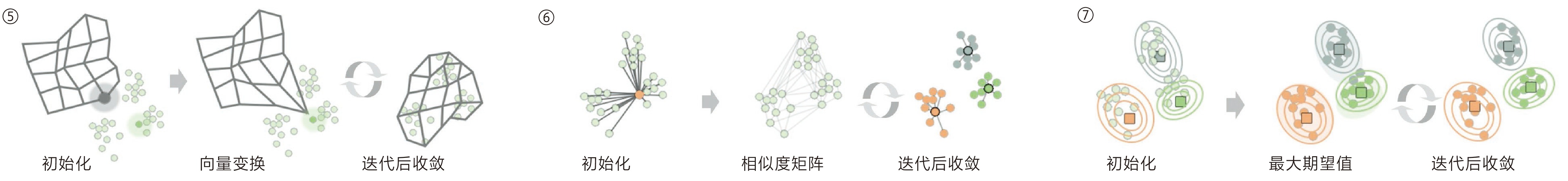
| 类型 | 方法 | 原理及特点 | 示意图 |
| 自上而下 | 叠图法 | 早期常用的景观分类方法,对不同类别的指标进行空间制图并赋权叠加后,对计算结果进行自上而下分类 | ① |
| 双向指示种分析(two-way indicator species analysis, TWINSPAN) | 遵循自上而下的分拆逻辑,从总体开始逐步一分为二,直到根据终止原则不能再分拆,广泛应用于植被群落研究中 | ② | |
| 自下而上 | K-means | 是一种基于距离的聚类算法,该算法设定好簇的个数K,随机创建K个质心,不断迭代收敛找出最优质心,将离质心最近的数据分配到对应簇中[29] | ③ |
| K中心聚类算法 (K-medoids) | 类似K-means,两者的不同之处在于K-medoids选择数据集的观测值为质心,而不是随机生成的点,该算法适用于处理异常数据,更适合空间对象 | ④ | |
| SOM | 是一种基于神经网络的聚类算法,依靠神经元之间的竞争学习机制适应输入数据的拓扑结构,从而将高维数据映射到低维空间中并进行可视化[29] | ⑤ | |
| 近邻传播算法 (affinity propagation, AP) | 将全部数据点作为潜在聚类中心,通过计算数据点之间的相似度构建相似度矩阵,通过算法收敛得到有代表性的数据点作为簇中心 | ⑥ | |
| GMM | 假设数据点服从多个高斯分布,对初始参数选择敏感,计算复杂度高[29] | ⑦ | |
 | |||
文中图表均由作者绘制,其中
| [1] |
司万维克, 高枫, 邓位. 英国景观特征评估[J]. 世界建筑, 2006 7): 23-27
SWANWICK C, GAO F, DENG W. Landscape Character Assessment in Britain[J]. World Architecture, 2006 7): 23-27.
|
| [2] |
LEWIS P H. Tomorrow by Design: A Regional Design Process for Sustainability[M]. New York: John Wiley&Sons Ltd, 1996.
|
| [3] |
SWANWICK C. Landscape Character Assessment: Guidance for England and Scotland[R]. Edinburgh: The Countryside Agency, 2002.
|
| [4] |
EVEILLARD-BUCHOUX M, BENINGER P G, CHADENAS C, et al. Small-Scale Natural Landscape Features and Seabird Nesting Sites: The Importance of Geodiversity for Conservation[J]. Landscape Ecology, 2019, 34(10): 2295-2306.
|
| [5] |
ISSAYEVA A, YESHIBAYEV A, LESKA B, et al. Comparative Assessment of Geomorphological and Landscape Character Around the Small Aral Sea[J]. Journal of Ecological Engineering, 2021, 22(10): 73-84
|
| [6] |
SCHMIDT K, MARTÍN-LÓPEZ B, PHILLIPS P M, et al. Key Landscape Features in the Provision of Ecosystem Services: Insights for Management[J]. Land Use Policy, 2019, 82 353-366
|
| [7] |
王云才, 马玥莹, 申佳可. 景观性格评价在国土空间规划和管控中的应用[J]. 风景园林, 2020, 27(1): 35-40
WANG Y C, MA Y Y, SHEN J K. Application of Landscape Personality Assessment in National Territory Spatial Planning and Control[J]. Landscape Architecture, 2020, 27(1): 35-40.
|
| [8] |
FAIRCLOUGH G, HERRING P. Lens, Mirror, Window: Interactions Between Historic Landscape Characterisation and Landscape Character Assessment[J]. Landscape Research, 2016, 41(2): 186-198
|
| [9] |
BUTLER A. Dynamics of Integrating Landscape Values in Landscape Character Assessment: The Hidden Dominance of the Objective Outsider[J]. Landscape Research, 2016, 41(2): 239-252
|
| [10] |
GALIANA-MARTIN L, HERRERO G, SOLANA J. A Wildland-Urban Interface Typology for Forest Fire Risk Management in Mediterranean Areas[J]. Landscape Research, 2011, 36(2): 151-171
|
| [11] |
BUTLER A, BERGLUND U. Landscape Character Assessment as an Approach to Understanding Public Interests Within the European Landscape Convention[J]. Landscape Research, 2014, 39(3): 219-236
|
| [12] |
ATIK M, IŞIKLI R C, ORTAÇEŞME V, et al. Definition of Landscape Character Areas and Types in Side Region, Antalya-Turkey with Regard to Land Use Planning[J]. Land Use Policy, 2015, 44 90-100.
|
| [13] |
CASPERSEN O H. Public Participation in Strengthening Cultural Heritage: The Role of Landscape Character Assessment in Denmark[J]. Geografisk Tidsskrift-Danish Journal of Geography, 2009, 109(1): 33-45
|
| [14] |
KIM K H, PAULEIT S. Landscape Character, Biodiversity and Land Use Planning: The Case of Kwangju City Region, South Korea[J]. Land Use Policy, 2007, 24(1): 264-274
|
| [15] |
BARTLETT D, GOMEZ-MARTIN E, MILLIKEN S, et al. Introducing Landscape Character Assessment and the Ecosystem Service Approach to India: A Case Study[J]. Landscape and Urban Planning, 2017, 167 257-266
|
| [16] |
张慧, 张媛. 景观特征评估(LCA)的应用价值[J]. 中国城市林业, 2018, 16(2): 74-79
ZHANG H, ZHANG Y. Application Value of Landscape Character Assessment[J]. Journal of Chinese Urban Forestry, 2018, 16(2): 74-79
|
| [17] |
黄昕珮. 论“景观”的本质: 从概念分裂到内涵统一[J]. 中国园林, 2009, 25(4): 26-29
HUANG X P. Discussion on the Essence of Landscape: From Disrupt Concepts to Unified Connotation[J]. Chinese Landscape Architecture, 2009, 25(4): 26-29
|
| [18] |
宋峰, 宋蕾蕾. 英美景观评估方法评述及借鉴[J]. 开发研究, 2016 5): 69-74
SONG F, SONG L L. Review and Reference of Landscape Assessment Methods in the UK and the US[J]. Research on Development, 2016 5): 69-74.
|
| [19] |
BEACH D, FLAMM B. Citizens Bioregional Plan for Northeast Ohio[J]. EcoCity Cleveland, 1999, 6 4-6.
|
| [20] |
GKOLTSIOU A, PARASKEVOPOULOU A. Landscape Character Assessment, Perception Surveys of Stakeholders and SWOT Analysis: A Holistic Approach to Historical Public Park Management[J]. Journal of Outdoor Recreation and Tourism, 2021, 35 100418
|
| [21] |
WARNOCK S, GRIFFITHS G. Landscape Characterisation: The Living Landscapes Approach in the UK[J]. Landscape Research, 2015, 40(3): 261-278
|
| [22] |
ATIK M, IŞIKLI R C, ORTAÇEŞME V, et al. Exploring a Combination of Objective and Subjective Assessment in Landscape Classification: Side Case from Turkey[J]. Applied Geography, 2017, 83 130-140
|
| [23] |
TERKENLI T, GKOLTSIOU A, KAVROUDAKIS D. The Interplay of Objectivity and Subjectivity in Landscape Character Assessment: Qualitative and Quantitative Approaches and Challenges[J]. Land, 2021, 10(1): 53
|
| [24] |
BROWN G, BRABYN L. An Analysis of the Relationships Between Multiple Values and Physical Landscapes at a Regional Scale Using Public Participation GIS and Landscape Character Classification[J]. Landscape and Urban Planning, 2012, 107(3): 317-331
|
| [25] |
BROWN G, BRABYN L. The Extrapolation of Social Landscape Values to a National Level in New Zealand Using Landscape Character Classification[J]. Applied Geography, 2012, 35(1/2): 84-94
|
| [26] |
GREG B, JESSICA M M, KATIE L. Public Participation GIS: A Method for Identifying Ecosystem Services[J]. Society & Natural Resources, 2012, 25(7): 633-651.
|
| [27] |
MARTÍN B, ORTEGA E, MARTINO P, et al. Inferring Landscape Change from Differences in Landscape Character Between the Current and a Reference Situation[J]. Ecological Indicators, 2018, 90 584-593
|
| [28] |
KOBLET O, PURVES R S. From Online Texts to Landscape Character Assessment: Collecting and Analysing First-Person Landscape Perception Computationally[J]. Landscape and Urban Planning, 2020, 197 103757
|
| [29] |
LU Y, XU S, LIU S, et al. An Approach to Urban Landscape Character Assessment: Linking Urban Big Data and Machine Learning[J]. Sustainable Cities and Society, 2022, 83 103983
|
| [30] |
李和平, 杨宁. 城市历史景观的管理工具: 城镇历史景观特征评估方法研究[J]. 中国园林, 2019, 35(5): 54-58
LI H P, YANG N. Research on the Management Tools of Historic Urban Landscape: Historic Townscape Characterisation[J]. Chinese Landscape Architecture, 2019, 35(5): 54-58.
|
| [31] |
王志芳, 周瑶瑾, 徐敏, 等. 县域景观特征管理单元划分方法: 以武胜县为例[J]. 北京大学学报(自然科学版), 2020, 56(3): 553-560
WANG Z F, ZHOU Y J, XU M, et al. Classification of County Natural Landscape Governance Units for Wusheng[J]. Acta Scientiarum Naturalium Universitatis Pekinensis, 2020, 56(3): 553-560.
|
| [32] |
周剑云, 蒋定哲, 鲍梓婷, 等. 历史景观特征评估: 链接保护区与城市历史景观[J]. 国际城市规划, 2023, 38(2): 124-132
ZHOU J Y, JIANG D Z, BAO Z T, et al. Historic Landscape Characterisation: Linking “Conservation Areas” and “Historic Urban Landscape”[J]. Urban Planning International, 2023, 38(2): 124-132.
|
| [33] |
汪伦, 张斌. 景观特征评估: LCA体系与HLC体系比较研究与启示[J]. 风景园林, 2018, 25(5): 87-92
WANG L, ZHANG B. Landscape Feature Assessment: Comparative Study and Inspiration Between LCA System and HLC System[J]. Landscape Architecture, 2018, 25(5): 87-92.
|
| [34] |
VAN E V, ANTROP M. A Stepwise Multi-scaled Landscape Typology and Characterisation for Trans-regional Integration, Applied on the Federal State of Belgium[J]. Landscape and Urban Planning, 2009, 91(3): 160-170.
|
| [35] |
YANG D C, GAO C, LI L Y, et al. Multi-scaled Identification of Landscape Character Types and Areas in Lushan National Park and Its Fringes, China[J]. Landscape and Urban Planning, 2020, 201 103844
|
| [36] |
KONKOLY-GYURÓ É. Conceptualisation and Perception of the Landscape and Its Changes in a Transboundary Area. A Case Study of the Southern German-French Borderland[J]. Land Use Policy, 2018, 79 556-574
|
| [37] |
MARTÍN B, ORTEGA E, OTERO I, et al. Landscape Character Assessment with GIS Using Map-Based Indicators and Photographs in the Relationship Between Landscape and Roads[J]. Journal of Environmental Management, 2016, 180 324-334
|
| [38] |
SHANNON S, SMARDON R, KNUDSON M. Using Visual Assessment as a Foundation for Greenway Planning in the St. Lawrence River Valley[J]. Landscape and Urban Planning, 1995, 33(1-3): 357-371
|
| [39] |
HERRING P C. Framing Perceptions of the Historic Landscape: Historic Landscape Characterisation (HLC) and Historic Land-Use Assessment (HLA)[J]. Scottish Geographical Journal, 2009, 125 61-77
|
| [40] |
TURNER S. Historic Landscape Characterisation: A Landscape Archaeology for Research, Management and planning[J]. Landscape Research, 2006, 31(4): 385-398.
|
| [41] |
TORREGGIANI D, LUDWICZAK Z, DALL’ARA E, et al. TRuLAn: A High-Resolution Method for Multi-time Analysis of Traditional Rural Landscapes and Its Application in Emilia-Romagna, Italy[J]. Landscape and Urban Planning, 2014, 124 93-103
|
| [42] |
MOU J, CHEN Z, HUANG J. Predicting Urban Expansion to Assess the Change of Landscape Character Types and Its Driving Factors in the Mountain City[J]. Land, 2023, 12(4): 928
|
| [43] |
CATALÁN B, SAURÍ D, SERRA P. Urban Sprawl in the Mediterranean?: Patterns of Growth and Change in the Barcelona Metropolitan Region 1993–2000[J]. Landscape and Urban Planning, 2008, 85(3-4): 174-184
|
| [44] |
MEDEIROS A, FERNANDES C, GONÇALVES J F, et al. A Diagnostic Framework for Assessing Land-Use Change Impacts on Landscape Pattern and Character: A Case-Study from the Douro Region, Portugal[J]. Landscape and Urban Planning, 2022, 228 104580
|
| [45] |
VAN EETVELDE V, ANTROP M. Indicators for Assessing Changing Landscape Character of Cultural Landscapes in Flanders (Belgium)[J]. Land Use Policy, 2009, 26(4): 901-910
|
| [46] |
BASTIAN O, RÖDER M. Assessment of Landscape Change by Land Evaluation of Past and Present Situation[J]. Landscape and Urban Planning, 1998, 41(3-4): 171-182.
|
| [47] |
鲍梓婷, 周剑云. 香港景观特征评估(LCA)的实践与经验[J]. 中国园林, 2015, 31(9): 100-104
BAO Z T, ZHOU J Y. The Practice and Experience of Landscape Character Assessment in Hong Kong[J]. Chinese Landscape Architecture, 2015, 31(9): 100-104
|
| [48] |
MÜCHER C A, KLIJN J A, WASCHER D M, et al. A New European Landscape Classification (LANMAP): A Transparent, Flexible and User-Oriented Methodology to Distinguish Landscapes[J]. Ecological Indicators, 2010, 10(1): 87-103.
|
| [49] |
CHUMAN T, ROMPORTL D. Multivariate Classification Analysis of Cultural Landscapes: An Example from the Czech Republic[J]. Landscape and Urban Planning, 2010, 98(3/4): 200-209.
|
| [50] |
SIMENSEN T, HALVORSEN R, ERIKSTAD L. Methods for Landscape Characterisation and Mapping: A Systematic Review[J]. Land Use Policy, 2018, 75 557-569.
|
| [51] |
刘文平, 宇振荣. 北京市海淀区景观特征类型识别及评价[J]. 生态学杂志, 2016, 35(5): 1338-1344
LIU W P, YU Z R. Identification and Assessment of Landscape Character of Haidian District, Beijing[J]. Chinese Journal of Ecology, 2016, 35(5): 1338-1344.
|
| [52] |
盛硕, 王云才. 基于生态特征与问题聚类识别的平原农业区乡村生态修复策略: 以辽宁省黑山县为例[J]. 中国园林, 2022, 38(12): 20-25
SHENG S, WANG Y C. Rural Ecological Restoration Strategies in Plain Agricultural Areas Based on the Identification of Ecological Characteristics and Issues Through Clustering: A Case Study of Heishan County, Liaoning Province[J]. Chinese Landscape Architecture, 2022, 38(12): 20-25.
|
| [53] |
高飞, 郭沁, 段广德. 蒙东农牧交错区乡村聚落文化景观区划研究[J]. 城市建筑, 2023, 20(5): 27-29
GAO F, GUO Q, DUAN G D. Research on the Zoning of Cultural Landscape of Rural Settlements in the Agro-Pastoral Area of Eastern Inner Mongolia[J]. Urbanism and Architecture, 2023, 20(5): 27-29.
|
| [54] |
李哲, 卢馨逸, 施佳颖, 等. 基于小圩形态指数的宣芜平原圩田景观肌理量化研究: 以固城湖永丰圩为例[J]. 中国园林, 2023, 39(1): 41-46
LI Z, LU X Y, SHI J Y, et al. Quantitative Research of Landscape Texture for Polders in Xuanwu Plain Based on Morphological Index: A Case Study of Yongfeng Polder, Gucheng Lake[J]. Chinese Landscape Architecture, 2023, 39(1): 41-46.
|
| [55] |
王金亮, 谢德体, 倪九派, 等. 基于源汇景观单元的流域土壤侵蚀风险格局识别[J]. 生态学报, 2017, 37(24): 8216-8226
WANG J L, XIE D T, NI J P, et al. Identification of Soil Erosion Risk Patterns in a Watershed Based on Source-sink Landscape Units[J]. Acta Ecologica Sinica, 2017, 37(24): 8216-8226.
|
| [56] |
陈慕婷, 周剑云, 鲍梓婷, 等. 省域湿地退化风险评价研究: 基于地理格网与景观特征单元的多尺度分析[J]. 中国园林, 2023, 39(4): 52-58
CHEN M T, ZHOU J Y, BAO Z T, et al. Study on Risk Assessment of Provincial Wetland Degradation-Based on Multi-scale Analysis of Geographical Grids and Landscape Character Units[J]. Chinese Landscape Architecture, 2023, 39(4): 52-58.
|
| [57] |
王云才, 陈照方, 成玉宁. 新时期乡村景观特征与景观性格的表征体系构建[J]. 风景园林, 2021, 28(7): 107-113
WANG Y C, CHEN Z F, CHENG Y N. The Representation System of Rural Landscape Character and Personality in the New Era[J]. Landscape Architecture, 2021, 28(7): 107-113.
|
| [58] |
鲍梓婷, 周剑云. 英国景观特征评估概述: 管理景观变化的新工具[J]. 中国园林, 2015 3): 46-50
BAO Z T, ZHOU J Y. Landscape Character Assessment in UK: A New Tool to Manage Landscape Change[J]. Chinese Landscape Architecture, 2015 3): 46-50.
|
| [59] |
ZHAO Y, HARVEY D C, GAO C. Identifying Shan-Shui Characteristics for National Landscape Heritage: Reconciling Western and Chinese Landscape Characterisation from a Trans-cultural Perspective[J]. The Geographical Journal, 2020, 186(3): 300-313
|
| [60] |
王云才. 基于空间生态特性的景观图式语言研究方法与方法论[J]. 风景园林, 2018, 25(1): 28-32
WANG Y C. The Research Method and Methodology of Pattern Language Based on Ecological Nature of Landscape Space[J]. Landscape Architecture, 2018, 25(1): 28-32.
|
| [61] |
陈照方, 王云才. 乡村景观单元识别与认知的空间生态智慧: 以南京市牌坊社区为例[J]. 风景园林, 2022, 29(7): 30-36
CHEN Z F, WANG Y C. Spatial Ecological Wisdom for Identification and Cognition of Rural Landscape Units: A Case Study of Nanjing Paifang Rural Community[J]. Landscape Architecture, 2022, 29(7): 30-36.
|
| [62] |
华琳, 黄志霖, 马良, 等. 三峡库区低山丘陵区多尺度景观指数响应及适宜粒度[J]. 生态学报, 2022, 42(11): 4703-4717
HUA L, HUANG Z L, MA L, et al. Suitable Granularity and Response of Multi-scale Landscape in Low Mountain and Hilly Area of the Three Gorges Reservoir[J]. Acta Ecologica Sinica, 2022, 42(11): 4703-4717.
|
| [63] |
华琳, 黄志霖, 马良, 等. 三峡库区低山丘陵区多尺度景观指数响应及适宜粒度[J]. 生态学报, 2022, 42(11): 4703-4717
HUA L, HUANG Z L, MA L, et al. Suitable Granularity and Response of Multi-scale Landscape in Low Mountain and Hilly Area of the Three Gorges Reservoir[J]. Acta Ecologica Sinica, 2022, 42(11): 4703-4717.
|
| [64] |
朱建宁. 展现地域自然景观特征的风景园林文化[J]. 中国园林, 2011, 27(11): 1-4
ZHU J N. Landscape Culture Reproducing Regional Natural Landscape Characteristics[J]. Chinese Landscape Architecture, 2011, 27(11): 1-4
|
/
| 〈 |
|
〉 |