
Construction of “Biomigration – Regional Cooling” Multi-functional Ecological Network in Wuhan Urban Agglomeration
|
LI Jiajie is a master student in the Faculty of Architecture and Urban Planning, Chongqing University. His research focuses on urban and rural ecological planning and design |
|
GU Yuanyuan, Ph.D., is an associate professor and master supervisor in the Faculty of Architecture and Urban Planning, Chongqing University. Her research focuses on Neo-Marxist urban theory, and urban formation |
|
XING Zhong, Ph.D., is a professor and doctoral supervisor in the Faculty of Architecture and Urban Planning, Chongqing University, a member of the Key Laboratory of New Technology for Construction of Cities in Mountain Area, Ministry of Education, and a member of the Ecological Planning Committee, Urban Planning Society of China. His research focuses on urban and rural ecological planning and design |
Received date: 2024-03-20
Revised date: 2024-11-12
Online published: 2025-12-07
Copyright
[Objective] Rapid urbanization has encroached on large ecological spaces, causing ecological issues like biodiversity loss, heat island effect, and flooding. To address this, ecological networks composed of source sites, corridors, and stepping-stone patches are proposed to restore landscape connectivity and integrity, thereby ensuring ecological security. However, these networks have primarily focused on biodiversity conservation, neglecting other benefits to humans. This research, therefore, constructs a multifunctional ecological network in Wuhan by combining a biomigration network and a regional cooling network. This network is used to identify key areas for ecological restoration and protection, with a view to offering a reference for landscape conservation.
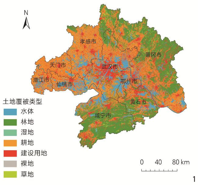
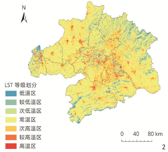
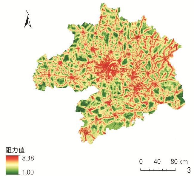
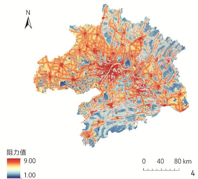
[Methods] In this research, the construction and optimization of the multifunctional network are divided into four steps. 1) Identification of two types of source patches. Based on the land cover and land surface temperature (LST) of Wuhan urban agglomeration, the research screens the biodiversity source sites and regional cold island source sites by morphological spatial pattern analysis (MSPA) and landscape connectivity. 2) Construction of two types of resistance surfaces. Based on land use type, elevation, slope, distance from road, distance from construction land, normalized difference vegetation index (NDVI) and other data, the resistance values of biomigration and cold island diffusion are calculated respectively, and raster resistance surfaces are generated in ArcGIS. 3) Based on minimum cumulative resistance (MCR) and circuit theory, biomigration corridors and regional cooling corridors are generated respectively by using the Linkage Mapper toolbox. 4) Two kinds of corridors are overlapped to form a multifunctional ecological network pattern, based on which the key areas for ecological protection and restoration are identified in Wuhan urban agglomeration.
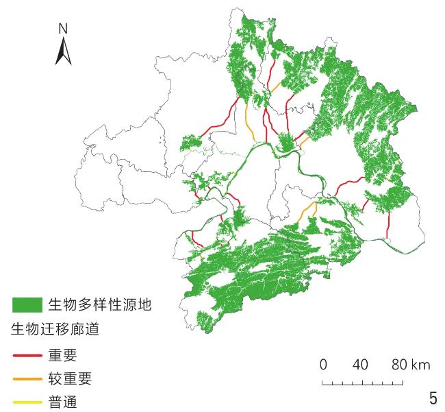
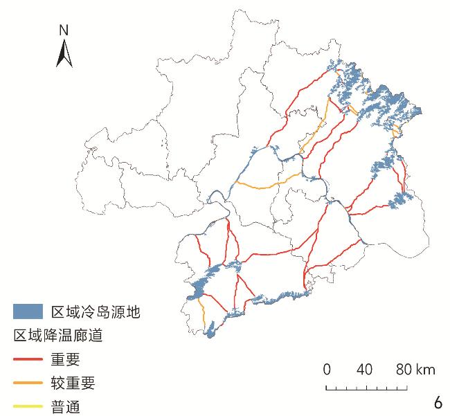
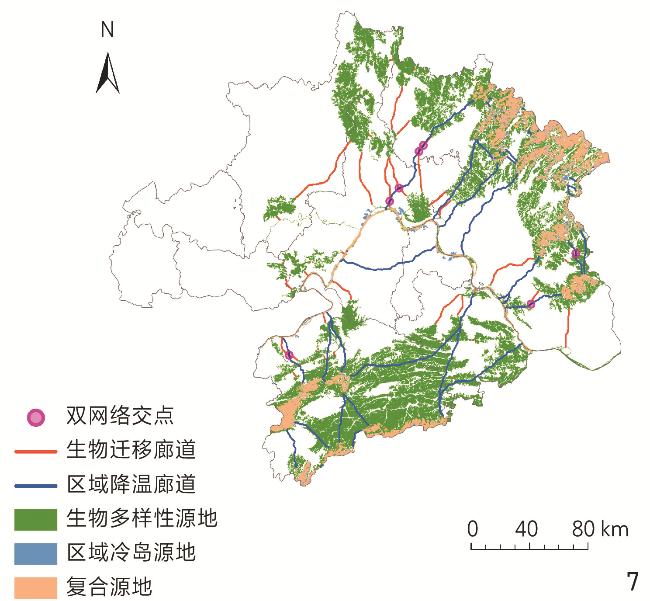
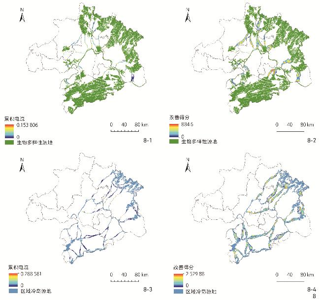
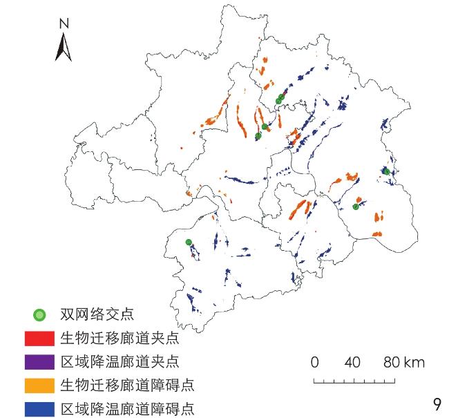
[Results] In this research, Wuhan urban agglomeration is taken as the research area. Based on land cover data, satellite remote sensing data and other sources of data, and by integrating the methods of MSPA, landscape connectivity analysis and surface temperature inversion, 22 biodiversity and 27 regional cooling sources are identified, both of which are distributed in the northeastern and southern parts of the research area. Based on the MCR model and circuit theory, the multifunctional ecological network pattern of Wuhan urban agglomeration is constructed with the help of Linkage Mapper toolbox, including 44 biomigration corridors and 51 regional cooling corridors. Finally, by identifying the intersections, pinch points and obstacle points of the dual networks, the key areas for ecological restoration and protection of national land space under the perspective of multifunctional ecological network are located, including 7 intersections of the dual networks (biomigration network and regional cooling network), 85.4 km2 of pinch points and 724.9 km2 of obstacle points in the biomigration network, and 50.1 km2 of pinch points and 926.6 km2 of obstacle points in the regional cooling network.
[Conclusion] Aiming to further enhance human well-being through ecological network, this research integrates the biomigration network and the regional cooling network into a cohesive multifunctional ecological network framework. This integrated network sustains the regular functioning of diverse ecological processes by interlinking the supply sources of various ecological functions, thereby amplifying the protective benefits of species habitats across urban and rural landscapes and augmenting the thermal comfort of human settlements. Additionally, the overlay of the two types of ecological corridors respectively corresponding to the aforesaid two networks substantially enhances the overall connectivity and stability of the ecological network pattern. In conclusion, this research proposes a strategic planning approach for ecological conservation and restoration, aimed at fostering the connectivity of a complex functional ecological network. This strategy encompasses the protection of existing ecological sources, the cultivation of potential sources, the restoration of impediments within the dual networks, and the safeguarding of critical pinch points and intersections. The findings of this research hold significant implications for the ecological security and sustainable development of Wuhan urban agglomeration, offering a reference for the construction of large-scale multifunctional ecological networks.
Jiajie LI , Yuanyuan GU , Zhong XING . Construction of “Biomigration – Regional Cooling” Multi-functional Ecological Network in Wuhan Urban Agglomeration[J]. Landscape Architecture, 2025 , 32(1) : 96 -104 . DOI: 10.3724/j.fjyl.202403200166
表1 地表温度等级划分标准及取值范围Tab. 1 Criteria and range of values for LST classes |
| 等级区域 | 划分标准 | 取值范围/℃ |
| 注: | ||
| 高温区 | ||
| 较高温区 | ||
| 次高温区 | ||
| 常温区 | ||
| 次低温区 | ||
| 较低温区 | ||
| 低温区 | ||
表2 生物迁移阻力因子及其权重Tab. 2 Biomigration resistance factors and their weights |
| 阻力因子 | 权重 | 分类 | 阻力值 | 阻力因子 | 权重 | 分类 | 阻力值 | |
| 土地覆被类型 | 0.22 | 林地 | 1 | 高程/m | 0.14 | 1 | ||
| 耕地、草地 | 3 | 50~ | 3 | |||||
| 裸地 | 5 | 150~ | 5 | |||||
| 水体、湿地 | 7 | 250~ | 7 | |||||
| 建设用地 | 9 | 9 | ||||||
| 坡度/° | 0.17 | 1 | 距道路距离/m | 0.29 | 1 | |||
| 3~ | 3 | 2 500~ | 3 | |||||
| 8~ | 5 | 1 500~ | 5 | |||||
| 15~ | 7 | 500~ | 7 | |||||
| 9 | 9 | |||||||
| 距建设用地 距离/m | 0.18 | 1 | ||||||
| 2 500~ | 3 | |||||||
| 1 500~ | 5 | |||||||
| 500~ | 7 | |||||||
| 9 |
表3 冷源扩散阻力因子及其权重Tab. 3 Cold source diffusion resistance factors and their weights |
| 阻力因子 | 权重 | 分类 | 阻力值 | 阻力因子 | 权重 | 分类 | 阻力值 | |
| 土地覆被类型 | 0.63 | 水体、湿地 | 1 | 高程/m | 0.08 | 1 | ||
| 林地 | 3 | 420~ | 3 | |||||
| 草地 | 5 | 227~ | 5 | |||||
| 耕地 | 7 | 89~ | 7 | |||||
| 建设用地、裸地 | 9 | 9 | ||||||
| 距道路距离/m | 0.18 | 1 | NDVI | 0.11 | 1 | |||
| 2 500~ | 3 | 0.67~ | 3 | |||||
| 1 500~ | 5 | 0.46~ | 5 | |||||
| 500~ | 7 | 0.17~ | 7 | |||||
| 9 | 9 |
表4 双网络构建方法对比Tab. 4 Comparison between of the construction methods of the dual networks |
| 网络 类型 | 源地识别 | 阻力面构建 | 廊道生成 | |||||||
| 识别机制 | 构成要素 | 构建逻辑 | 权重指标 | 细节差异 | 功能目标 | 连接内容 | 生成方法 | |||
| 生物 迁移 网络 | 基于土地覆被类型 识别连通性较高的 大型生境斑块 | 以林地、草地、湿地、水体等自然生境为主 | 考虑地表要素对生 物迁移过程的影响 | 本网络中各因子权重差距较小,“距道路距离”具有最大权重(0.29) | 由于水体、湿地会阻碍生物运动,在生物迁移综合阻力面中为高阻力区域;高程越大,阻力越强 | 作为生物迁移的 高效路径 | 不同生物 多样性源地 | 基于Linkage Mapper 工具中的 Build Network and Map Linkages 模块 | ||
| 区域 降温 网络 | 通过地表温度反演 与分级识别地表热 环境中的低温斑块 | 区域热环境中能够减缓热岛效应的汇景观 | 考虑制约冷源在景观 格局中扩散的因素 | 本网络中各因子权重差距较大,“土地覆被类型”具有最大权重(0.63) | 由于水体、湿地具有较高热吸收能力,在冷岛综合阻力面中为低阻力区域;高程越大,阻力越弱 | 作为冷源扩散的 生态流通道 | 不同区域 冷岛源地 | |||
图8 武汉城市圈双网络累积电流与改善得分Fig. 8 Cumulative currents and improvement scores of the dual networks in Wuhan urban agglomeration |
文中图表均由作者绘制,其中图片底图来自国家地理信息公共服务平台(天地图,https://cloudcenter.tianditu.gov.cn/administrativeDivision),审图号为GS(2024)0650号。
| [1] |
尹海伟, 孔繁花, 祈毅, 等. 湖南省城市群生态网络构建与优化[J]. 生态学报, 2011, 31(10): 2863-2874
YIN H W, KONG F H, QI Y, et al. Developing and Optimizing Ecological Networks in Urban Agglomeration of Hunan Province[J]. Acta Ecologica Sinica, 2011, 31(10): 2863-2874.
|
| [2] |
孔繁花, 尹海伟. 济南城市绿地生态网络构建[J]. 生态学报, 2008, 28(4): 1711-1719
KONG F H, YIN H W. Developing Green Space Ecological Networks in Jinan City[J]. Acta Ecologica Sinica, 2008, 28(4): 1711-1719
|
| [3] |
彭建, 赵会娟, 刘焱序, 等. 区域生态安全格局构建研究进展与展望[J]. 地理研究, 2017, 36(3): 407-419
PENG J, ZHAO H J, LIU Y X, et al. Research Progress and Prospect on Regional Ecological Security Pattern Construction[J]. Geographical Research, 2017, 36(3): 407-419.
|
| [4] |
CHEN X Q, KANG B Y, LI M Y, et al. Identification of Priority Areas for Territorial Ecological Conservation and Restoration Based on Ecological Networks: A Case Study of Tianjin City, China[J]. Ecological Indicators, 2023, 146 109809
|
| [5] |
FORMAN R T T, GODRON M. Landscape Ecology[M]. New York: Wiley, 1986.
|
| [6] |
岳邦瑞, 康世磊, 江畅. 城市—区域尺度的生物多样性保护规划途径研究[J]. 风景园林, 2014, 21(1): 42-46
YUE B R, KANG S L, JIANG C. Discussion on the Biodiversity Protection Planning Methods Based on Urban-Regional Scale[J]. Landscape Architecture, 2014, 21(1): 42-46
|
| [7] |
俞孔坚. 生物保护的景观生态安全格局[J]. 生态学报, 1999, 19(1): 10-17
YU K J. Landscape Ecological Security Patterns in Biological Conservation[J]. Acta Ecologica Sinica, 1999, 19(1): 10-17
|
| [8] |
许峰, 尹海伟, 孔繁花, 等. 基于MSPA与最小路径方法的巴中西部新城生态网络构建[J]. 生态学报, 2015, 35(19): 6425-6434
XU F, YIN H W, KONG F H, et al. Developing Ecological Networks Based on MSPA and the Least-Cost Path Method: A Case Study in Bazhong Western New District[J]. Acta Ecologica Sinica, 2015, 35(19): 6425-6434.
|
| [9] |
罗言云, 谭小昱, 何柳燕, 等. 大熊猫国家公园邛崃山-大相岭片区生态网络构建及优化[J]. 风景园林, 2022, 29(8): 93-101
LUO Y Y, TAN X Y, HE L Y, et al. Construction and Optimization of Ecological Network in the Qionglai Mountain – Daxiangling Area of Giant Panda National Park[J]. Landscape Architecture, 2022, 29(8): 93-101.
|
| [10] |
李波, 贺萌, 彭琳, 等. 基于林鸟迁移扩散的重庆市高密度城区生态网络构建研究[J]. 中国园林, 2023, 39(7): 35-39
LI B, HE M, PENG L, et al. Research on the Construction of Ecological Network in the High-Density Urban Area of Chongqing Based on the Migration and Diffusion of Forest Birds[J]. Chinese Landscape Architecture, 2023, 39(7): 35-39.
|
| [11] |
曹秀凤, 刘兆顺, 李淑杰, 等. 基于生态安全格局的国土空间生态修复关键区域识别: 以吉林省松原市为例[J]. 中国环境科学, 2022, 42(6): 2779-2787
CAO X F, LIU Z S, LI S J, et al. Identification of Key Areas of Ecological Protection and Restoration Based on the Pattern of Ecological Security: A Case Of Songyuan City, Jilin Province[J]. China Environmental Science, 2022, 42(6): 2779-2787
|
| [12] |
王秀明, 赵鹏, 龙颖贤, 等. 基于生态安全格局的粤港澳地区陆域空间生态保护修复重点区域识别[J]. 生态学报, 2022, 42(2): 450-461
WANG X M, ZHAO P, LONG Y X, et al. Identification of Key Areas of Land Space Ecological Protection and Restoration Based on the Pattern of Ecological Security in Guangdong, Hong Kong and Macau[J]. Acta Ecologica Sinica, 2022, 42(2): 450-461.
|
| [13] |
朱捷, 苏杰, 尹海伟, 等. 基于源地综合识别与多尺度嵌套的徐州生态网络构建[J]. 自然资源学报, 2020, 35(8): 1986-2001
ZHU J, SU J, YIN H W, et al. Construction of Xuzhou Ecological Network Based on Comprehensive Sources Identification and Multi-scale Nesting[J]. Journal of Natural Resources, 2020, 35(8): 1986-2001
|
| [14] |
卢洁, 焦胜, 胡加琦, 等. 基于多尺度协同的长沙市生态网络构建与层级优化[J]. 生态学报, 2023, 43(15): 6332-6344
LU J, JIAO S, HU J Q, et al. Construction and Hierarchical Optimization of Changsha Ecological Network Based on Multi-scale Collaboration[J]. Acta Ecologica Sinica, 2023, 43(15): 6332-6344.
|
| [15] |
费凡, 尹海伟, 孔繁花, 等. 基于二维与三维信息的南京市主城区生态网络格局对比分析[J]. 生态学报, 2020, 40(16): 5534-5545
FEI F, YIN H W, KONG F H, et al. Comparative Analysis of Ecological Network Pattern Using 2D and 3D Information in Main Urban Area of Nanjing, China[J]. Acta Ecologica Sinica, 2020, 40(16): 5534-5545.
|
| [16] |
王一鸣, 尹海伟, 孔繁花, 等. 顾及屋顶绿化的城市三维生态网络构建: 以南京市中心城区为例[J]. 生态学报, 2023, 43(22): 9121-9132
WANG Y M, YIN H W, KONG F H, et al. Construction of Urban 3D Ecological Network Considering Green Roofs: A Case Study of Downtown Nanjing[J]. Acta Ecologica Sinica, 2023, 43(22): 9121-9132.
|
| [17] |
王倩娜, 谢梦晴, 张文萍, 等. 成渝城市群区域生态与城镇发展双网络格局分析及时空演变[J]. 生态学报, 2023, 43(4): 1380-1398
WANG Q N, XIE M Q, ZHANG W P, et al. Regional Pattern Analysis and Spatio-Temporal Evolution of Ecological and Urban Dual Network in Chengdu-Chongqing Urban Agglomeration[J]. Acta Ecologica Sinica, 2023, 43(4): 1380-1398.
|
| [18] |
马彩虹, 刘园园, 杨航, 等. 宁夏灵武市“生态-经济”双网格局演变及互作关系[J]. 应用生态学报, 2023, 34(11): 3095-3104
MA C H, LIU Y Y, YANG H, et al. Evolution and Interaction Relationship of “Eco-Economy” Dual Grid Pattern in Lingwu City, Ningxia, China[J]. Chinese Journal of Applied Ecology, 2023, 34(11): 3095-3104.
|
| [19] |
沈舟, 尹海伟, 孔繁花, 等.基于生境组团化分析与景观廊道模拟的南京市白鹭生境网络构建与优化[J].生态学报, 2024, 44(8): 3303-3316.
SHEN Z, YIN H W, KONG F H, et al. Establishment and Optimization of Egretta garzetta Habitat Network in Nanjing Based on Habitat Grouping Analysis and Landscape Corridors Simulation[J]. Acta Ecologica Sinica, 2024, 44(8): 3303-3316.
|
| [20] |
李权荃, 金晓斌, 宋家鹏, 等. 基于尺度嵌套与复合功能视角的高强度城市化地区生态网络体系研究: 以江阴市为例[J]. 生态学报, 2023, 43(22): 9133-9147
LI Q Q, JIN X B, SONG J P, et al. Ecological Network System of Highly Urbanized Area Based on Scale Nesting and Composite Function: A Case Study of Jiangyin City[J]. Acta Ecologica Sinica, 2023, 43(22): 9133-9147.
|
| [21] |
孙博, 王会军, 黄艳艳, 等. 2022年夏季中国高温干旱气候特征及成因探讨[J]. 大气科学学报, 2023, 46(1): 1-8
SUN B , WANG H J, HUANG Y Y, et al. Characteristics and Causes of the Hot-Dry Climate Anomalies in China During Summer of 2022[J]. Transactions of Atmospheric Sciences, 2023, 46(1): 1-8.
|
| [22] |
QIAN W Q, LI X Y. A Cold Island Connectivity and Network Perspective to Mitigate the Urban Heat Island Effect[J]. Sustainable Cities and Society, 2023, 94 104525
|
| [23] |
张文萍, 庄子薛, 谢梦晴, 等. 基于电路理论的多尺度城市热环境网络构建及格局优化: 以成都市中心城区为例[J]. 中国园林, 2023, 39(4): 103-108
ZHANG W P, ZHUANG Z X, XIE M Q, et al. Construction and Pattern Optimization of Multiscale Urban Thermal Environment Network Based on Circuit Theory: A Case Study of the Central Urban Area of Chengdu[J]. Chinese Landscape Architecture, 2023, 39(4): 103-108.
|
| [24] |
黄贞斌, 李红波. 武汉城市圈土地利用及生态系统服务价值时空演变多情景模拟[J]. 长江流域资源与环境, 2023, 32(12): 2542-2557
HUANG Z B, LI H B. Multi-scenario Simulation of Temporal-Spatial Evolution of Land Uses and Ecosystem Services in Wuhan Urban Agglomeration[J]. Resources and Environment in the Yangtze Basin, 2023, 32(12): 2542-2557.
|
| [25] |
WANG T, LI H B, HUANG Y. The Complex Ecological Network’s Resilience of the Wuhan Metropolitan Area[J]. Ecological Indicators, 2021, 130 108101
|
| [26] |
易予晴, 龙腾飞, 焦伟利, 等. 武汉城市群夏季热岛特征及演变[J]. 长江流域资源与环境, 2015, 24(8): 1279-1285
YI Y Q, LONG T F, JIAO W L, et al. Characteristics and Evolution of the Summer Heat Island Effect in Wuhan City Group[J]. Resources and Environment in the Yangtze Basin, 2015, 24(8): 1279-1285
|
| [27] |
王存钱. 城市化对武汉城市圈气候变化的影响研究[D]. 武汉: 华中师范大学, 2019.
WANG C Q. Analysis of Urbanization Effects on Climate in Wuhan Metropolitan Area[D]. Wuhan: Central China Normal University, 2019.
|
| [28] |
吴昌广, 周志翔, 王鹏程, 等. 景观连接度的概念、度量及其应用[J]. 生态学报, 2010, 30(7): 1903-1910
WU C G, ZHOU Z X, WANG P C, et al. The Concept and Measurement of Landscape Connectivity and Its Applications[J]. Acta Ecologica Sinica, 2010, 30(7): 1903-1910.
|
| [29] |
高静, 龚健, 李靖业. “源-汇”景观格局的热岛效应研究: 以武汉市为例[J]. 地理科学进展, 2019, 38(11): 1770-1782
GAO J, GONG J, LI J Y. Effects of Source and Sink Landscape Pattern on Land Surface Temperature: An Urban Heat Island Study in Wuhan City[J]. Progress in Geography, 2019, 38(11): 1770-1782
|
| [30] |
谢启姣. 城市热岛演变及其影响因素研究[D]. 武汉: 华中农业大学, 2011.
XIE Q J. Urban Heat Island Effect Change and the Major Affecting Variables Analysis[D]. Wuhan: Huazhong Agricultural University, 2011.
|
| [31] |
邸俊楠, 苏涛, 雷波, 等. 基于“源-汇”景观格局的城市热岛效应及影响因素分析: 以合肥市为例[J]. 中国环境科学, 2023, 43(11): 6039-6050
DI J N, SU T, LEI B, et al. Analysis of Urban Heat Island Effect and Influencing Factors Based on the “Source-Sink” Landscape Pattern: A Case Study of Hefei[J]. China Environmental Science, 2023, 43(11): 6039-6050.
|
| [32] |
姜之点, 杨峰. 建筑立体绿化方式和设计高度对三维空间降温潜力的影响[J]. 风景园林, 2023, 30(5): 75-82
JIANG Z D, YANG F. Influence of Green Building Planting Form and Design Height on Cooling Potential of 3D Space[J]. Landscape Architecture, 2023, 30(5): 75-82
|
| [33] |
陈明, 戴菲. 基于形态学空间格局分析的城市绿地对热环境的影响研究[J]. 生态环境学报, 2021, 30(1): 125-134
CHEN M, DAI F. The Influence of Urban Green Spaces on Thermal Environment Based on Morphological Spatial Pattern Analysis[J]. Ecology and Environmental Sciences, 2021, 30(1): 125-134.
|
| [34] |
GAO W, ZHENG C, LIU X, et al. NDVI-Based Vegetation Dynamics and Their Responses to Climate Change and Human Activities from 1982 to 2020: A Case Study in the Mu Us Sandy Land, China[J]. Ecological Indicators, 2022, 137 108745
|
| [35] |
MCRAE B H, DICKSON B G, KEITT T H, et al. Using Circuit Theory to Model Connectivity in Ecology, Evolution, and Conservation[J]. Ecology, 2008, 89(10): 2712-2724
|
| [36] |
刘阳, 欧小杨, 郑曦. 整合绿地结构与功能性连接分析的城市生物多样性保护规划[J]. 风景园林, 2022, 29(1): 26-33
LIU Y, OU X Y, ZHENG X. Urban Biodiversity Conservation Planning Integrating Green Space Structural and Functional Connection Analysis[J]. Landscape Architecture, 2022, 29(1): 26-33.
|
| [37] |
黄梅, 刘晨曦, 俞晓莹, 等. 城市水生态网络韧性评价与优化策略: 以长沙市为例[J]. 经济地理, 2022, 42(10): 52-60
HUANG M, LIU C X, YU X Y, et al. Resilience Evaluation and Optimization of Urban Water Ecological Network: Take Changsha as an Example[J]. Economic Geography, 2022, 42(10): 52-60.
|
| [38] |
方云皓, 赵丽元, 窦碧莹, 等. 基于MSPA-CIRCUIT的长江中游城市群热环境网络识别与评价研究[J]. 生态环境学报, 2023, 32(7): 1237-1248
FANG Y H, ZHAO L Y, DOU B Y, et al. Research on the Identification and Evaluation of Thermal Environment Networks in Urban Agglomerations of the Middle Reaches of the Yangtze River Based on MSPA-CIRCUIT[J]. Ecology and Environmental Sciences, 2023, 32(7): 1237-1248.
|
| [39] |
邢忠, 李佳杰, 顾媛媛. “城中田”保护利用刍议: 价值认知、问题识别与路径探讨[J]. 城市发展研究, 2024, 31(6): 118-125
XING Z, LI J J, GU Y Y. Ruminations on the Protection and Utilization of “Urban Farmland”: Value Perception, Problem Identification and Path Discussion[J]. Urban Development Studies, 2024, 31(6): 118-125
|
/
| 〈 |
|
〉 |