
Identification and Spatial Mapping of Locality of Streetscapes in Shanghai Hengfu Historic and Cultural Preservation Area
|
SHAO Yuhan, Ph.D., is an associate professor and doctoral supervisor in the College of Architecture and Urban Planning (CAUP), Tongji University, and director of the Restorative Urbanism Research Center (RURC) of the Joint International Research Laboratory of Eco-urban Design, Ministry of Education. Her research focuses on restorative landscape health mechanism and landscape character preservation |
|
YIN Sinan, is a Ph.D. candidate in the College of Architecture and Urban Planning (CAUP), Tongji University. Her research focuses on theory and method of planning, construction and governance of urban sustainable development |
|
MA Dongbo is an urban planner in Shanghai Tongji Urban Planning and Design Institute, Co., Ltd. His research focuses on application of big data and artificial intelligence technology in urban planning research |
|
YIN Yuting, Ph.D., is an associated research fellow in the School of Design, East China Normal University, and a visiting research fellow in Shanghai Key Laboratory of Urban Renewal and Spatial Optimization Technology. Her research focuses on restorative landscape planning and design, and theory and method of multi-sensory landscape perception |
Received date: 2024-03-18
Revised date: 2024-12-15
Online published: 2025-12-07
Copyright
[Objective] As one of the major open spaces, urban streets not only carry the transportation function, but also promote social interaction and economic growth, while displaying the aesthetic, cultural and historical characteristics of the city. However, many new or regenrated streets have gradually lost their identity due to the compromise of large-scale construction and short-term delivery. It is important to explore ways to protect and optimize the locality of streetscape since street constituents the most direct impression of a city, which not only forms the identity of a city together with architecture, historical and cultural heritage, geographical characteristics and social life, but also serves as an independent carrier of local expression. The identification and optimization of streetscape locality can help protect the uniqueness of landscape, enhance urban identity and construct urban image, especially for historical and cultural preservation areas in modern cities, and can also work as an important step to retain urban memory and enhance residents’ sense of belonging.
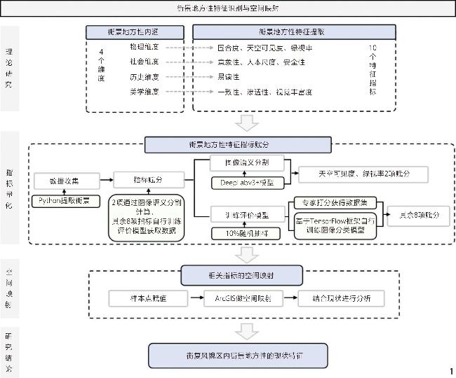
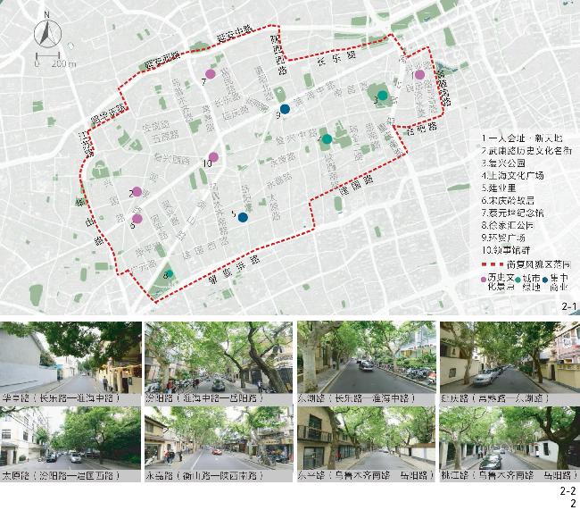
[Methods] This research first establishes a theoretic framework for streetscape locality through a discussion based on literature reviewed. The research proposes that streetscape locality should include the physical, social, historical and aesthetic aspects, with relevant indicators being identified for the four aspects respectively. These indicators are then compared with streetscape characteristics that can be measured by current image analysis technologies. On this basis, a framework for identification of streetscape locality is constructed. Taking Shanghai Hengfu Historic and Cultural Preservation Area (hereinafter referred to as the “Area”) as an example, the research adopts the semantic segmentation method and an AI-based evaluation model to analyze the locality of the Area, with the specific process being visualized using the Geographic Information System (GIS). The current spatial expression of streetscape locality characteristics in the Area is then discussed considering factors such as land use on both sides of a street, architectural styles, and traffic hierarchies.
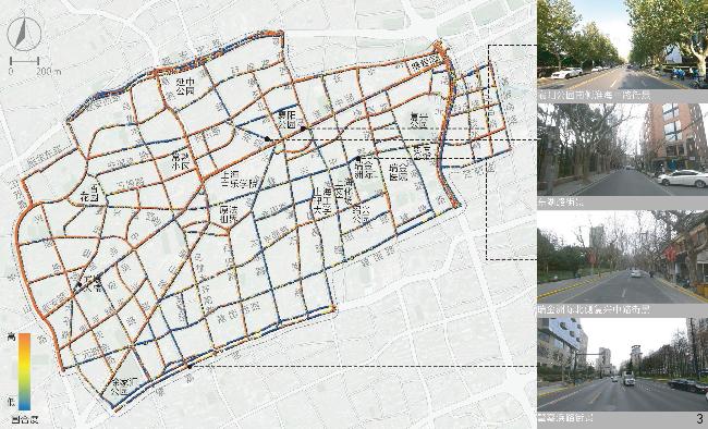
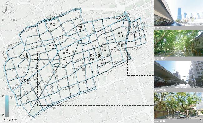
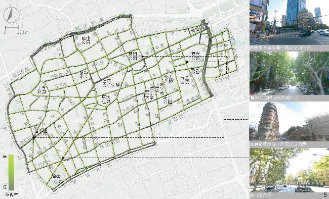
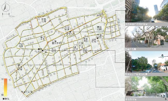
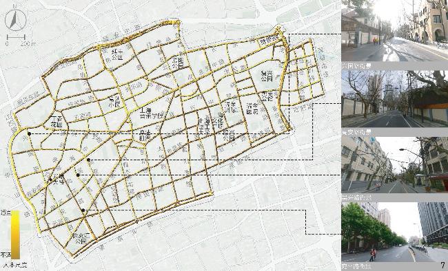
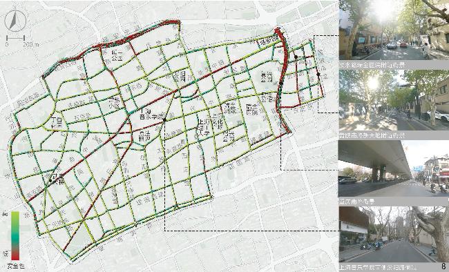
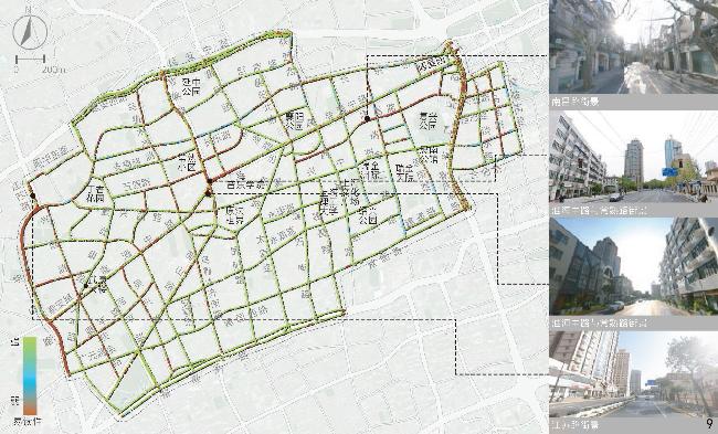
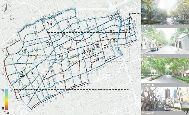
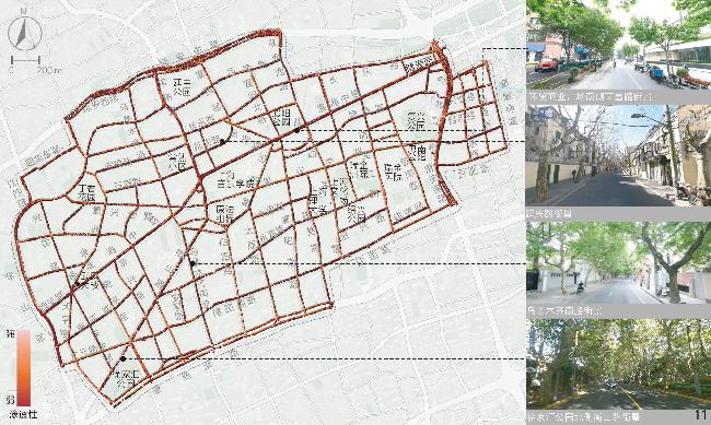
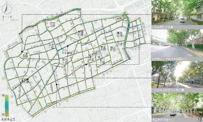
[Results] Results suggest that in the aspect of physical locality, the indicators of enclosing degree, green visibility and sky visibility are consistent in spatial distribution. Specifically, the distribution of sky visibility is basically opposite to green visibility, while enclosing degree is similarly distributed with sky visibility. In general, the enclosing degree of the Area is rated moderate, while the green visibility and sky visibility of streetscape are rated at a medium to low level. Streetscape in the northern and western parts of the Area is relatively open compared with other parts and the highest green visibility is observed in streets around Xujiahui Park located in the southwestern part of the Area. In the social aspect, safety is rated good overall, but the human scale is rated moderate and the imageability level is low. Streetscape with appropriate human scale is safer than others, which may be due to the fact that both the two human scale and safety characteristics can positively influence the comfort of perception. Overall, safety and human scale characteristics are poor in the central part of the Area around Shanghai Conservatory of Music, the intersection betwwen Huaihai Middle Road and Fuxing Middle Road, as well as Yan’an Middle Road in the north and Chongqing South Road in the east of the Area. Besides, the streetscape imageability of the Area is only rated high where unique landmarks exist. In the historic aspect, legibility of the Area appears to be better in the southern part while rated poorest in the central part and western boundary of the Area, especially in Jiangsu Road and Nanchang Road close to the north side of the Fuxing Park. Among the characteristics in relation to aesthetic aspect, visual diversity, coherence and permeability show no direct or indirect correlation with each other in spatial distribution. The visual diversity and coherence of streetscape are rated good in the research area, but the permeability of streetscape is less satisfied. The visual diversity of streetscape at the intersection between Changshu Road and Huaihai Middle Road and along Jianguo West Road in the south is poor, and the permeability is also quite poor. In addition, the roads with low traffic hierarchy such as branches and alleys are generally rated better than those with high traffic hierarchy in terms of human scale, coherence and permeability.
[Conclusion] This research may provide a reference for subsequent protection, optimization and development of urban streetscape locality, and may also inspire more large-scale analysis of landscape concepts derived from sociology, anthropology and other disciplines in the future. Constrained by the accuracy of the algorithm model adopted and the availability of the streetscape image data collected, there may exist slight error in the analysis results. However, the research in general has succeeded in quantitatively measuring and mapping the locality of streetscape within the research area.
Yuhan SHAO , Sinan YIN , Dongbo MA , Yuting YIN . Identification and Spatial Mapping of Locality of Streetscapes in Shanghai Hengfu Historic and Cultural Preservation Area[J]. Landscape Architecture, 2025 , 32(2) : 110 -119 . DOI: 10.3724/j.fjyl.202403180161
表1 城市街景地方性特征识别框架[40-47]Tab. 1 A framework for identification of the locality of urban streetscape[40-47] |
| 特征维度 | 特征指标 | 指标描述 |
| 物理维度 | 围合度 | 街景视野中边界所定义的空间感,通常由街道宽度与沿街界面高度决定[40] |
| 天空可见度 | 街景视野中天空占画面的百分比[41] | |
| 绿视率 | 街景视野中植被(如行道树、绿化带、垂直绿化等)占画面的百分比[42] | |
| 社会维度 | 意象性 | 描述街景的可识别性和可记忆性,受物理特征、人们的心理感知和社会文化因素等综合影响[43] |
| 人本尺度 | 街道和街道空间中各元素设计尺度与人们行为习惯、心理需求的匹配程度[44] | |
| 安全性 | 街道环境特征和管理维护状态能让人们心理上感到安全的程度[44] | |
| 历史维度 | 易读性 | 街道空间结构可以被人们理解的难易程度[45] |
| 美学维度 | 一致性 | 街道空间各元素设计特征在视觉上统一性和整体性[46] |
| 渗透性 | 街景两侧沿街界面允许视线穿透的程度[47] | |
| 视觉丰富度 | 街景视野中可见的元素种类、数量等特征多样性程度[46] |
文中图表均由作者绘制,其中
| [1] |
FRIEDMANN J. Place and Place-Making in Cities: A Global Perspective[J]. Planning Theory & Practice, 2010, 11(2): 149-165.
|
| [2] |
WEI J X, YUE W Z, LI M M, et al. Mapping Human Perception of Urban Landscape from Street-View Images: A Deep-Learning Approach[J]. International Journal of Applied Earth Observation and Geoinformation, 2022, 112 102886
|
| [3] |
汪芳, 李薇, PROMINSKI Martin. 城镇化和地方性的新冲突、新策略与新探索: 中德双边研讨会会议综述[J]. 地理研究, 2014, 33(11): 2205-2214
WANG F, LI W, MARTIN P. The New Conflicts, Strategies and Explorations of Urbanization and Locality: Overview on the Sino-german Symposium[J]. Geographical Research, 2014, 33(11): 2205-2214.
|
| [4] |
SHAO Y H, LANGE E, THWAITES K, et al. Defining Local Identity[J]. Landscape Architecture Frontiers, 2017, 5(2): 24-41.
|
| [5] |
PROSHANSKY H M, ITTELSON W H, RIVLIN L G. Environmental Psychology: Man and His Physical Setting[M]. New York: Holt, Rinehart and Winston, 1970.
|
| [6] |
EISENHAUER W B, KRANNICH R S, BLAHNA D J. Attachments to Special Places on Public Lands: An Analysis of Activities, Reason for Attachments, and Community Connections[J]. Society & Natural Resources, 2000, 13(5): 421-441.
|
| [7] |
PRITCHARD A, MORGAN N J. Culture, Identity and Tourism Representation: Marketing Cymru or Wales?[J]. Tourism Management, 2001, 22(2): 167-179
|
| [8] |
HAY R. Sense of Place in Developmental Context[J]. Journal of Environmental Psychology, 1998, 18(1): 5-29
|
| [9] |
STOKOLS D. People in Places: A Transactional View of Settings[J]. Cognition, Social Behavior, and the Environment, 1981, 441(488):
|
| [10] |
QIAN J X, ZHU H. Chinese Urban Migrants' Sense of Place: Emotional Attachment, Identity Formation, and Place Dependence in the City and Community of Guangzhou[J]. Asia Pacific Viewpoint, 2014, 55(1): 81-101
|
| [11] |
PROSHANSKY H M, FABIAN A K, KAMINOFF R. Place-Identity: Physical World Socialization of the Self[J]. Journal of Environmental Psychology, 1983, 3(1): 57-83
|
| [12] |
杨振山, 吴笛, 杨定. 迁居意愿、地方依赖和社区认同: 北京中关村地区居住选择调查分析[J]. 地理科学进展, 2019, 38(3): 417-427
YANG Z S, WU D, YANG D. Willingness to Move, Place Dependence and Community Identity: An Investigation of Residential Choice in the Zhongguancun Area in Beijing[J]. Progress in Geography, 2019, 38(3): 417-427
|
| [13] |
STOBBELAAR D J, PEDROLI B. Perspectives on Landscape Identity: A Conceptual Challenge[J]. Landscape Research, 2011, 36(3): 321-339
|
| [14] |
DEVINE-WRIGHT P, LYONS E. Remembering Pasts and Representing Places: The Construction of National Identities in Ireland[J]. Journal of Environmental Psychology, 1997, 17(1): 33-45
|
| [15] |
SHAO Y H, LANGE E, THWAITES K, et al. Understanding Landscape Identity in the Context of Rapid Urban Change in China[J]. Land, 2020, 9(9): 298
|
| [16] |
何悦, 陈荣, 张云路. 基于原住民地方依恋的新型农村社区公共景观感知与优化策略: 以北京田仙峪村为例[J]. 风景园林, 2022, 29(3): 31-36
HE Y, CHEN R, ZHANG Y L. Perception and Optimization Strategies of Public Landscape in New Rural Communities Based on Place Attachment of Indigenous People: A Case Study of Beijing Tianxianyu Village[J]. Landscape Architecture, 2022, 29(3): 31-36.
|
| [17] |
ROSENBAUM M S, MONTOYA D Y. Am I Welcome Here? Exploring how Ethnic Consumers Assess Their Place Identity[J]. Journal of Business Research, 2007, 60(3): 206-214
|
| [18] |
BELANCHE D, CASALÓ L V, RUBIO M Á. Local Place Identity: A Comparison Between Residents of Rural and Urban Communities[J]. Journal of Rural Studies, 2021, 82 242-252
|
| [19] |
DEL P P B, GONZÁLEZ P A. Industrial Heritage and Place Identity in Spain: From Monuments to Landscapes[J]. Geographical Review, 2012, 102(4): 446-464
|
| [20] |
GOSPODINI A. Urban Morphology and Place Identity in European Cities: Built Heritage and Innovative Design[J]. Journal of Urban Design, 2004, 9(2): 225-248
|
| [21] |
DAVIS P. Place Exploration: Museums, Identity, Community[M]. London: Routledge, 2007.
|
| [22] |
LOW S M. Spatializing Culture: The Ethnography of Space and Place[M]. London: Routledge, 2016.
|
| [23] |
MORENO C, ALLAM Z, CHABAUD D, et al. Introducing the “15-Minutes City” Sustainability, Resilience and Place Identity in Future Post-Pandemic Cities[J]. Smart Cities, 2021, 4(1): 93-111
|
| [24] |
李嘉宁. 基于街景图片数据的中德城市地方性度量和比较研究[D]. 北京: 北京大学, 2020.
LI J N. Measurement and Comparative Study of Urban Locality Between China and Germany Based on Street View Image Data[D]. Beijing: Peking University, 2020.
|
| [25] |
LEWICKA M. Place Attachment, Place Identity, and Place Memory: Restoring the Forgotten City Past[J]. Journal of Environmental Psychology, 2008, 28(3): 209-231
|
| [26] |
王磊, 章璇, 韩昊英, 等. 基于时序街景数据的城市街道绿化结构演变: 以上海市中心城区为例[J]. 风景园林, 2024, 31(9): 42-50
WANG L, ZHANG X, HAN H Y, et al. Evolution of Urban Street Greening Structure Based on Time Series Street View Data: A Case Study of the Central Urban Area of Shanghai[J]. Landscape Architecture, 2024, 31(9): 42-50
|
| [27] |
邵钰涵, 殷雨婷, 薛贞颖. 基于街景大数据的北京、上海街景舒适度评价及比较[J]. 风景园林, 2021, 28(1): 53-59
SHAO Y H, YIN Y T, XUE Z Y. Evaluation and Comparison of Streetscape Comfort in Beijing and Shanghai Based on a Big Data Approach with Street Images[J]. Landscape Architecture, 2021, 28(1): 53-59.
|
| [28] |
RAFIEMANZELAT R. Influence of Place Identity on Walkability: A Comparative Study Between Two Mixed Used Streets Chaharbagh St. Isfahan, Iran and Dereboyu St. Lefkosa, North Cyprus[J]. World Academy of Science, Engineering and Technology, 2017 10): 255-264.
|
| [29] |
叶宇, 黄成成, 李心恬, 等. 人本视角街道绿视率与鸟瞰视角绿化覆盖率的表现差异及影响因素解析[J]. 风景园林, 2023, 30(9): 20-28
YE Y, HUANG C C, LI X T, et al. Mapping the Differences Between Human-Scaled Visible Street Greenery vs. Green Coverage from Bird's-Eye View and a Further Exploration of the Effecting Issues[J]. Landscape Architecture, 2023, 30(9): 20-28
|
| [30] |
ZENG L Y, LU J, LI W Y, et al. A Fast Approach for Large-Scale Sky View Factor Estimation Using Street View Images[J]. Building and Environment, 2018, 135 74-84
|
| [31] |
叶宇, 张灵珠, 颜文涛, 等. 街道绿化品质的人本视角测度框架: 基于百度街景数据和机器学习的大规模分析[J]. 风景园林, 2018, 25(8): 24-29
YE Y, ZHANG L Z, YAN W T, et al. Measuring Street Greening Quality from Humanistic Perspective: A Large-Scale Analysis Based on Baidu Street View Images and Machine Learning Algorithms[J]. Landscape Architecture, 2018, 25(8): 24-29.
|
| [32] |
KORALAGE C, PERERA R, WIJESUNDARA J. The Influence of Building-Street Interface on Fostering Public Activities[C]//ICCPP. Proceedings of the International Conference on “Cities, People and Places”-ICCPP-2023. Colombo: ICPP, 2023: 350-365.
|
| [33] |
郭馨, 赖建东, 马志锋, 等. 街道品质虚拟评价与现场调研评价方法的一致性分析: 以深圳轨道核心区街道为例[J]. 规划师, 2022, 38(6): 70-78
GUO X, LAI J D, MA Z F, et al. A Study on the Consistency Between Street View Survey and On-Site Survey: Shenzhen Example[J]. Planners, 2022, 38(6): 70-78
|
| [34] |
唐婧娴, 龙瀛, 翟炜, 等. 街道空间品质的测度、变化评价与影响因素识别: 基于大规模多时相街景图片的分析[J]. 新建筑, 2016, 5(5): 110-115
TANG J X, LONG Y, ZHAI W, et al. Measuring Quality of Street Space, Its Temporal Variation and Impact Factors: An Analysis Based on Massive Street View Pictures[J]. New Architecture, 2016, 5(5): 110-115.
|
| [35] |
YIN Y T, SHAO Y H, XUE Z Y, et al. An Explorative Study on the Identification and Evaluation of Restorative Streetscape Elements[J]. Landscape Architecture Frontiers, 2020, 8(4): 76-89
|
| [36] |
SHAO Y H, YIN Y T, XUE Z Y, et al. Assessing and Comparing the Visual Comfort of Streets Across Four Chinese Megacities Using AI-Based Image Analysis and the Perceptive Evaluation Method[J]. Land, 2023, 12(4): 834
|
| [37] |
ZHANG F, ZHANG D, LIU Y, et al. Representing Place Locales Using Scene Elements[J]. Computers, Environment and Urban Systems, 2018, 71 153-164
|
| [38] |
DUBEY A, NAIK N, PARIKH D, et al. Deep Learning the City: Quantifying Urban Perception at a Global Scale[C]//LEIBE B, MATAS J, SEBE N, et al. Computer Vision−ECCV 2016. Cham: Springer International Publishing, 2016: 196-212.
|
| [39] |
GAO S, JANOWICZ K, MONTELLO D R, et al. A Data-Synthesis-Driven Method for Detecting and Extracting Vague Cognitive Regions[J]. International Journal of Geographical Information Science, 2017, 31(6): 1245-1271.
|
| [40] |
EWING R H, CLEMENTE O. Measuring Urban Design: Metrics for Livable Places[M]. Washington, D. C.: Island Press, 2013.
|
| [41] |
董贺轩, 高翔. 街道植物空间对步行愉悦度的影响[J]. 风景园林, 2023, 30(1): 54-62
DONG H X, GAO X. Influence of Street Plant Space on Walking Pleasure[J]. Landscape Architecture, 2023, 30(1): 54-62
|
| [42] |
LIU M, JIANG Y, HE J L. Quantitative Evaluation on Street Vitality: A Case Study of Zhoujiadu Community in Shanghai[J]. Sustainability, 2021, 13(6): 3027
|
| [43] |
徐磊青, 江文津, 陈筝. 公共空间安全感研究: 以上海城市街景感知为例[J]. 风景园林, 2018, 25(7): 23-29
XU L Q, JIANG W J, CHEN Z. Study on Perceived Safety in Public Spaces: Take Perception of Street View in Shanghai as an Example[J]. Landscape Architecture, 2018, 25(7): 23-29.
|
| [44] |
李鹍, 薛丽莲. 街景围合度与城市风环境的量化关系研究: 以武汉市夏季为例[J]. 生态城市与绿色建筑, 2018 3): 52-56
LI K, XUE L L. Research on the Quantitative Relationship Between Streetscape Enclosure and Urban Wind Environment: Taking the Summer in Wuhan as an Example[J]. Eco-city and Green Building, 2018 3): 52-56.
|
| [45] |
KÖSEOĞLU E, MENGI Ç V. Streetscape Perception: Interaction of Perceived Legibility and Sense of Security in the Streets of Hasköy, Beyoğlu[J]. A+Arch Design International Journal of Architecture and Design, 2017, 3(1): 13-24.
|
| [46] |
WANG L, HAN X, HE J, et al. Measuring Residents' Perceptions of City Streets to Inform Better Street Planning Through Deep Learning and Space Syntax[J]. ISPRS Journal of Photogrammetry and Remote Sensing, 2022, 190 215-230
|
| [47] |
邵源, 叶丹, 叶宇. 基于街景数据和深度学习的街道界面渗透率大规模测度研究: 以上海为例[J]. 国际城市规划, 2023, 38(6): 39-47
SHAO Y, YE D, YE Y. Measuring the Transparency of Street Interface Based on Street View Images and Deep Learning: Taking Shanghai as an Example[J]. Urban Planning International, 2023, 38(6): 39-47.
|
| [48] |
鲍柏江, 王林, 薛鸣华. 上海历史风貌区巷弄精细化治理路径探索: 以徐汇区衡复历史文化风貌区为例[J]. 上海城市规划, 2023, 172(5): 92-97
BAO B J, WANG L, XUE M H. Delicacy Governance Path of Alley in Historical Areas of Shanghai: A Case Study of the Xuhui Hengfu Historical and Cultural Area[J]. Shanghai Urban Planning Review, 2023, 172(5): 92-97.
|
| [49] |
FANG Z G, LIU C, XIAO Y. Evaluation of Street Aesthetics and Influencing Factors Using Multi-source Deep Learning Methods: The Case Study of Shanghai[J]. International Urban Planning, 2023, 38(6): 48-58.
|
| [50] |
PARK Y, GARCIA M. Pedestrian Safety Perception and Urban Street Settings[J]. International Journal of Sustainable Transportation, 2020, 14(11): 860-871
|
| [51] |
马俊来. 面向规划衔接的完整街道详细分类方法[J]. 城市交通, 2021, 19(4): 100-111
MA J L. Detailed Complete Streets Classification for Planning Integration[J]. Urban Transport of China, 2021, 19(4): 100-111.
|
| [52] |
刘悦来, 周安锌. 从自然疗愈到社会修复: 公共健康视角下社区花园的疗愈价值探索[J]. 风景园林, 2024, 31(5): 103-115
LIU Y L, ZHOU A X. From Natural Healing to Social Restoration: Exploring the Healing Value of Community Gardens from the Perspective of Public Health[J]. Landscape Architecture, 2024, 31(5): 103-115
|
| [53] |
LI X, LYU Z H, ZHENG Z G, et al. Assessment of Lively Street Network Based on Geographic Information System and Space Syntax[J]. Multimedia Tools and Applications, 2017, 76(17): 17801-17819
|
| [54] |
LYNCH K. The Image of the City[M]. Cambridge: The MIT Press, 2023.
|
| [55] |
RAPOPORT A. The Meaning of the Built Environment: A Nonverbal Communication Approach[M]. Beverly Hills: Sage Publications, 1982.
|
| [56] |
ERKARTAL P O, UZUNKAYA A. Transparency as a Component of Public Space[J]. IOP Conference Series: Materials Science and Engineering, 2019, 471 092026
|
/
| 〈 |
|
〉 |