
基于热岛网络的城市闲置地绿化潜力评估——以杭州市核心城区为例
|
徐宁/女/东南大学建筑学院景观学系副系主任、副教授、博士生导师/研究方向为风景园林规划设计理论与方法、数字化城市设计理论与方法 |
|
樊澄珉/女/东南大学建筑学院在读硕士研究生/研究方向为风景园林规划设计理论与方法 |
|
王璞/女/东南大学建筑学院在读博士研究生/研究方向为风景园林规划设计理论与方法 |
Copy editor: 王一兰
收稿日期: 2025-08-19
修回日期: 2026-03-06
网络出版日期: 2026-04-22
基金资助
国家重点研发计划“多尺度多性能协同模型自动生成与智能优化”(2024YFC3809202)
国家自然科学基金面上项目“城市生态网络与公共空间的耦合机理及其数字化规划方法研究”(52378046)
江苏省研究生实践创新计划“时空视角下城市生态网络与公共空间系统耦合机理研究”(SJCX25_0135)
Assessment of Urban Vacant Lands Greening Potential Based on an Urban Heat Island Network: A Case Study of the Core Urban Area of Hangzhou
|
XU Ning, Ph.D., is deputy director of, an associate professor and a doctoral supervisor in the Department of Landscape Architecture, School of Architecture, Southeast University. Her research focuses on theories and methods of landscape planning and design, and theories and methods of digital urban design |
|
FAN Chengmin is a master student in the School of Architecture, Southeast University. Her research focuses on theories and methods of landscape planning and design |
|
WANG Pu is a Ph.D. candidate in the School of Architecture, Southeast University. Her research focuses on theories and methods of landscape planning and design |
Received date: 2025-08-19
Revised date: 2026-03-06
Online published: 2026-04-22
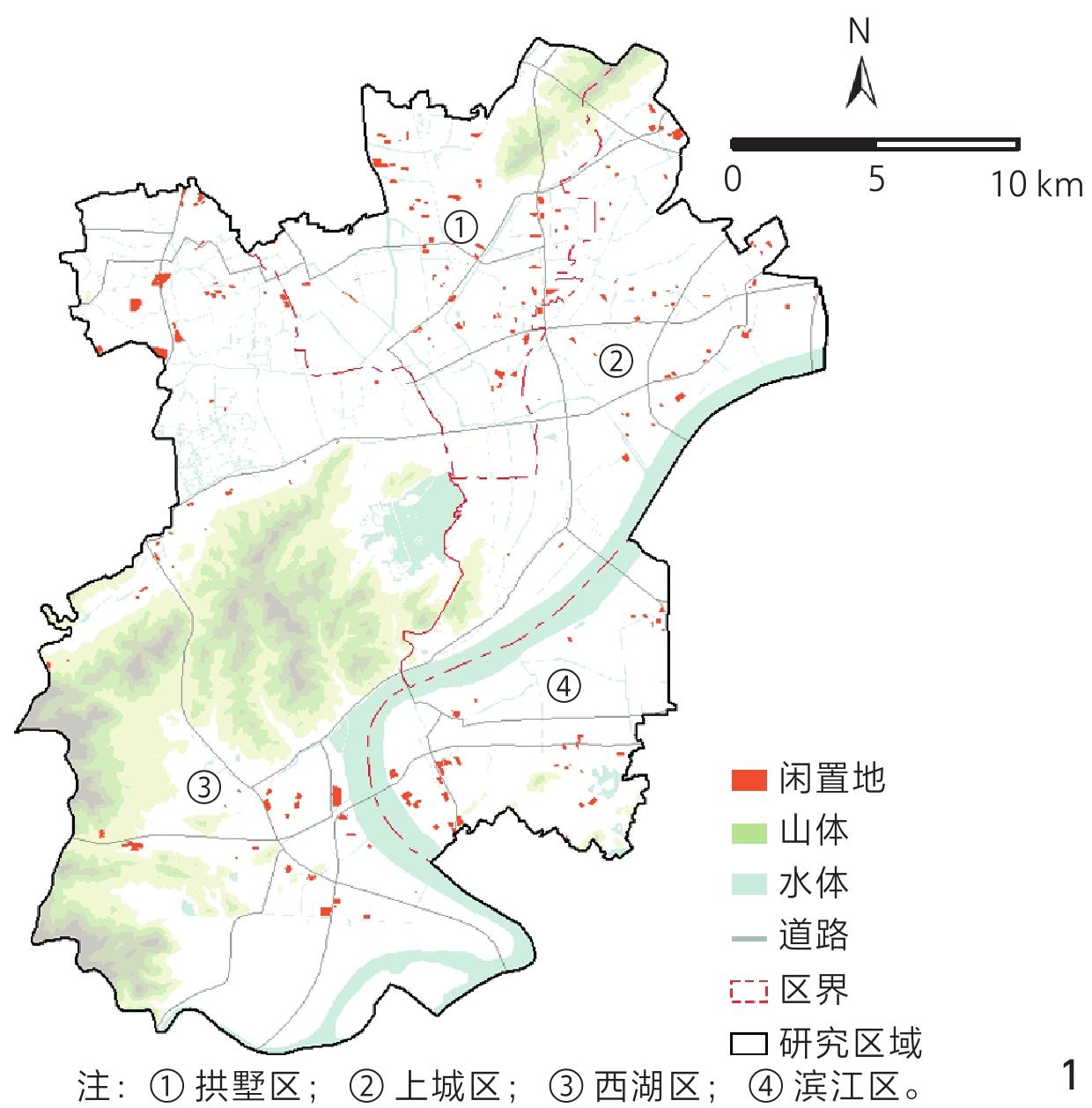
在全球气候变化与快速城市化背景下,高强度城市开发导致热岛源地相互连通,城市热岛效应加剧。然而,高密度城市中热岛源地的空间连通性如何形成并影响城市热环境,城市闲置地分布与热岛网络之间是否存在结构性关联,以及如何科学确定闲置地的绿化改造优先级以缓解热岛效应,仍是亟待解决的科学问题。
以杭州市核心城区为研究对象,综合形态学空间格局分析、热环境连通性、电路理论与阈值效应分析,系统构建了基于热岛网络连通性的城市闲置地绿化潜力评估框架。
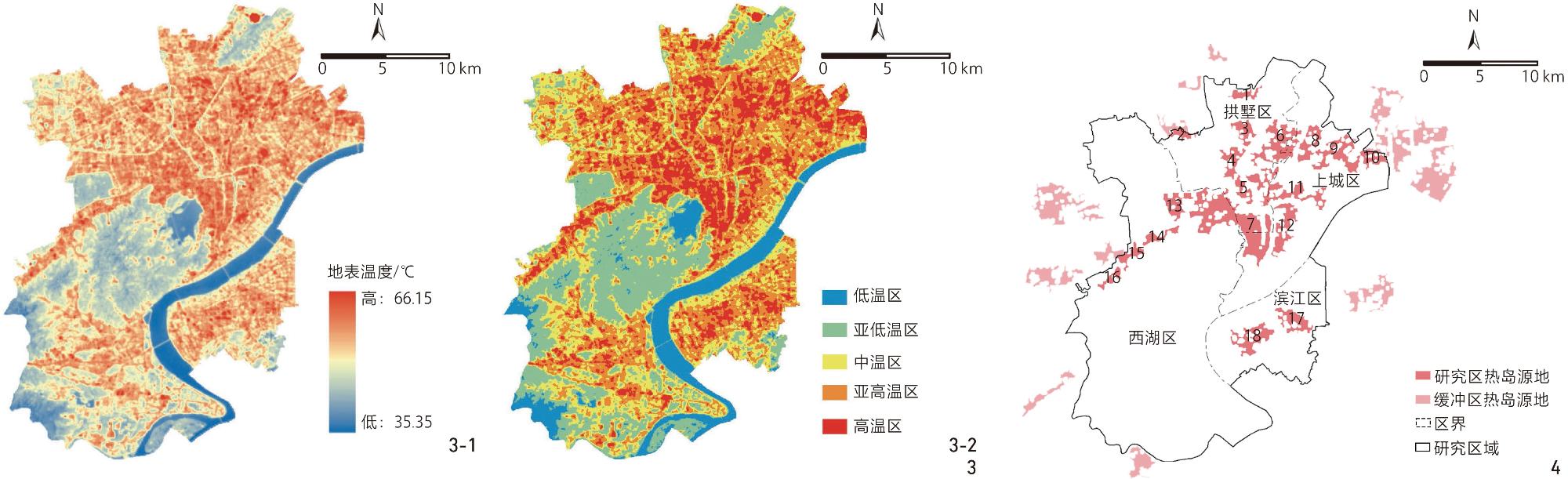
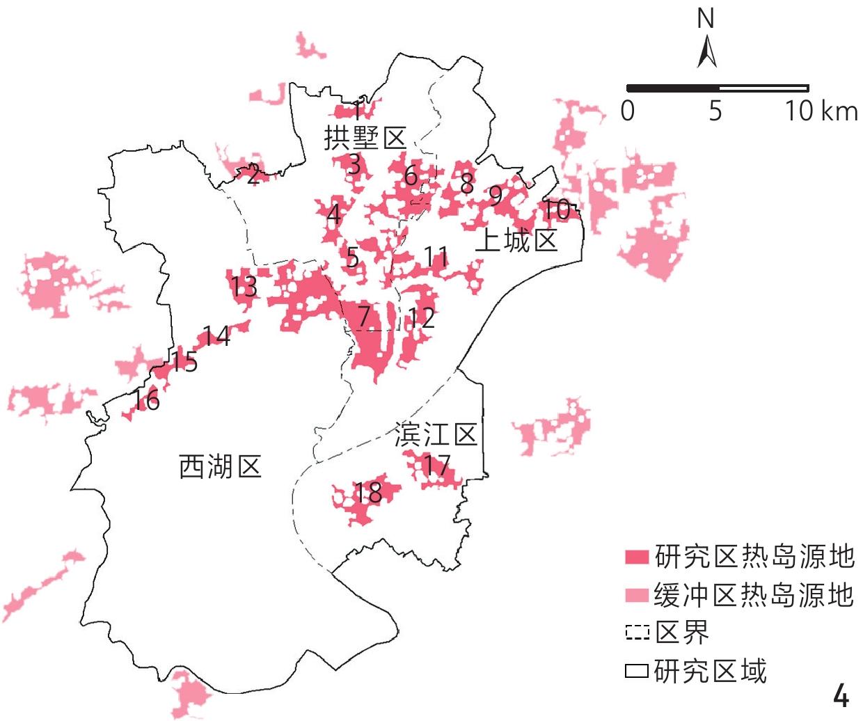
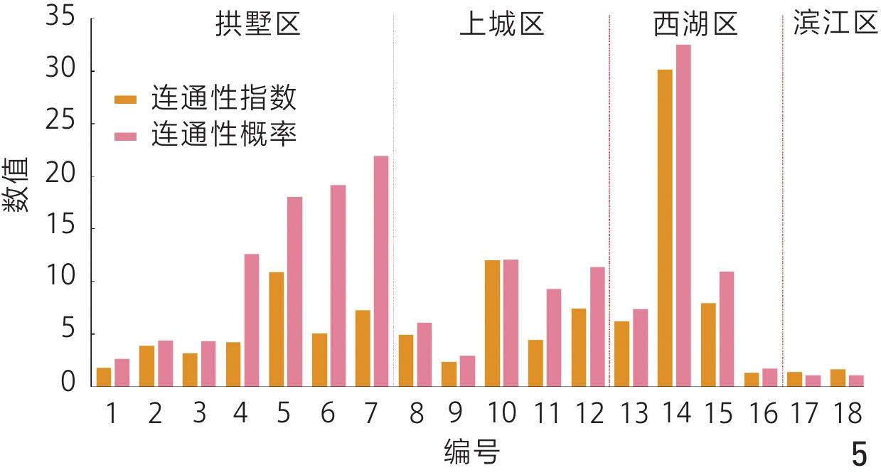
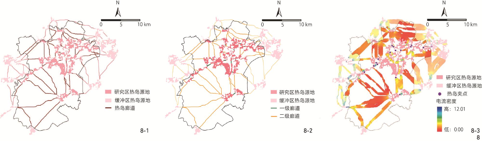
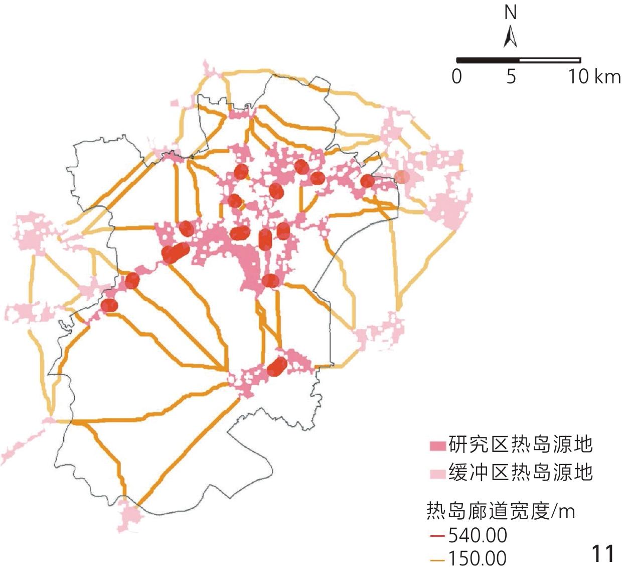
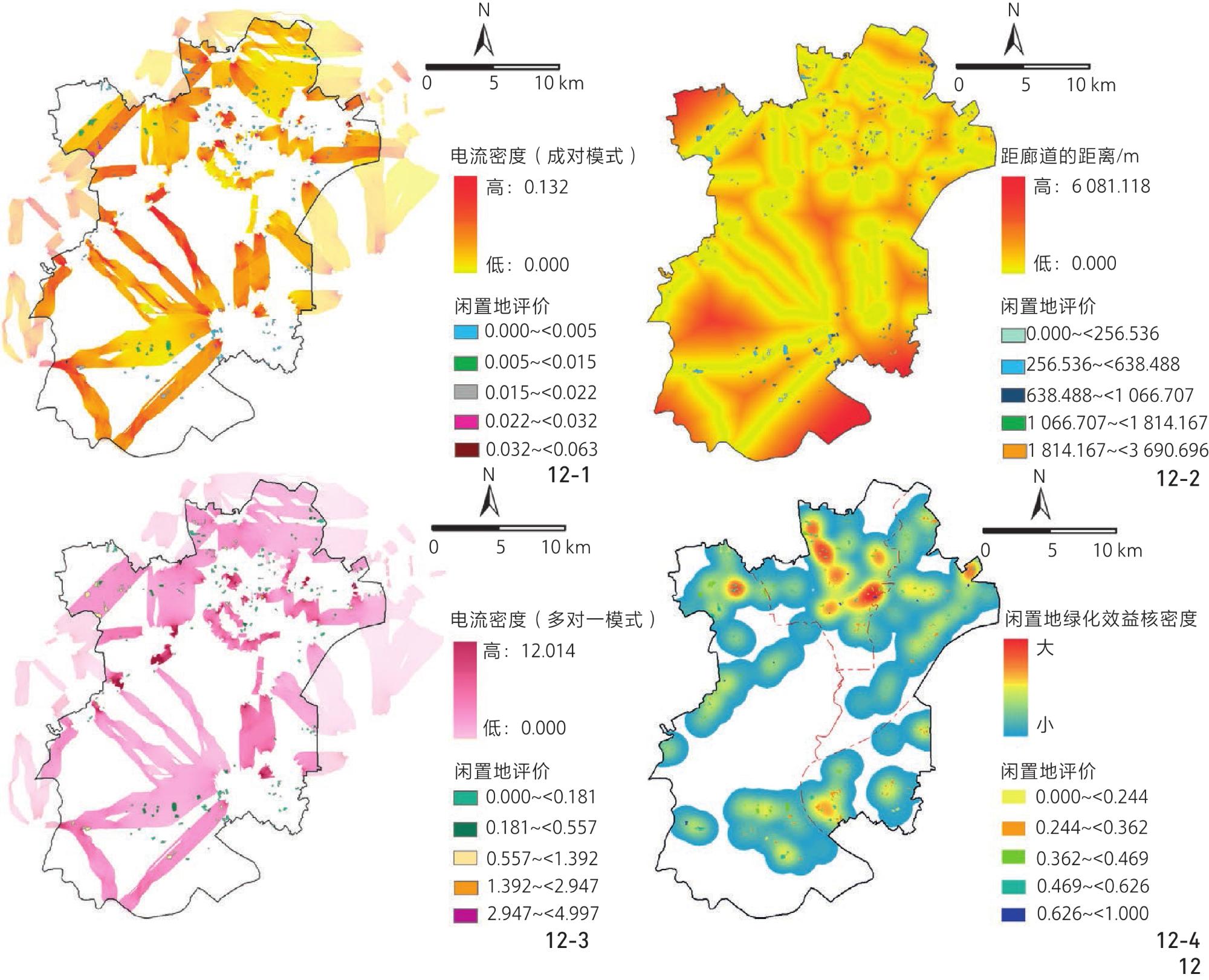
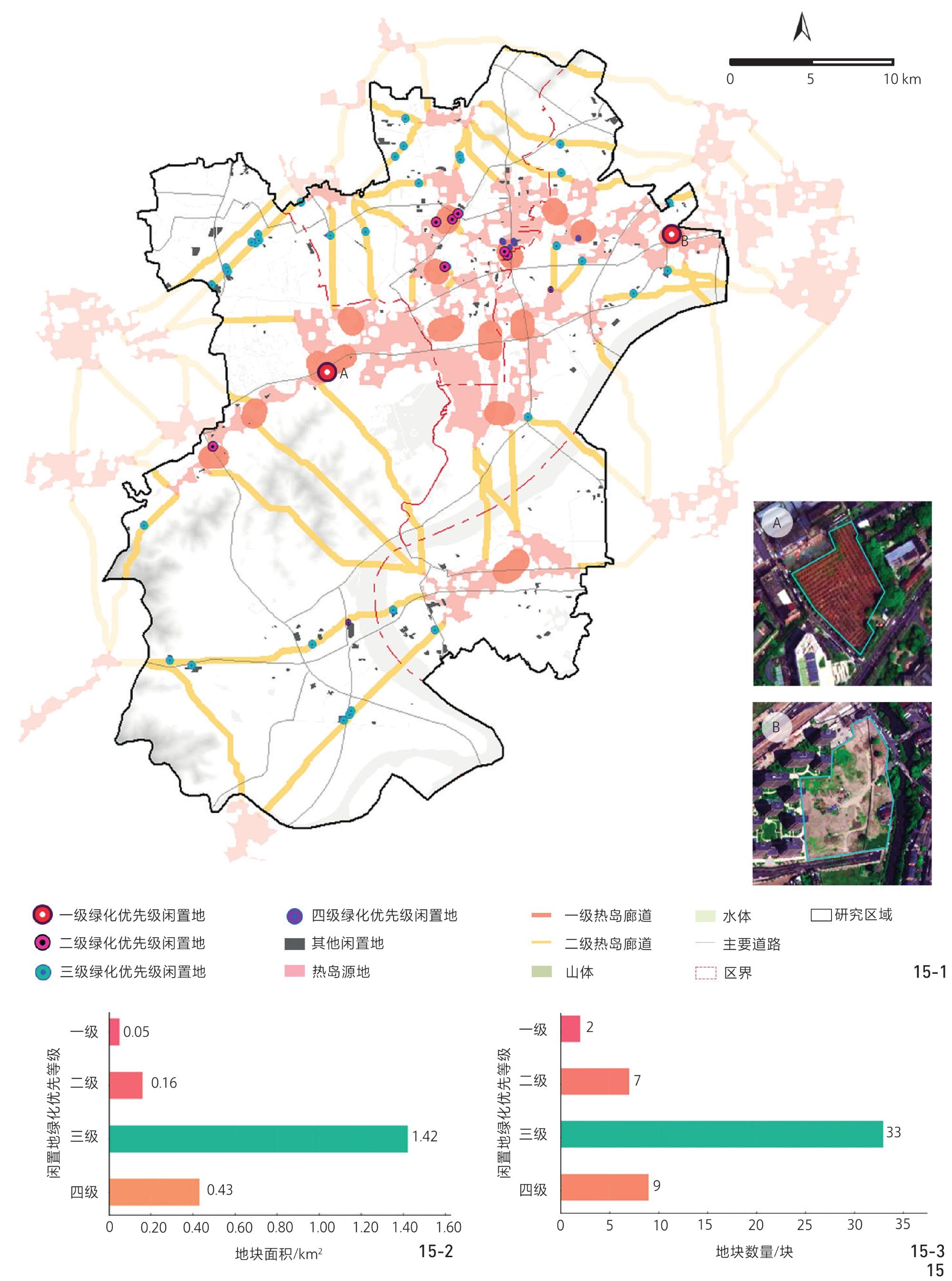
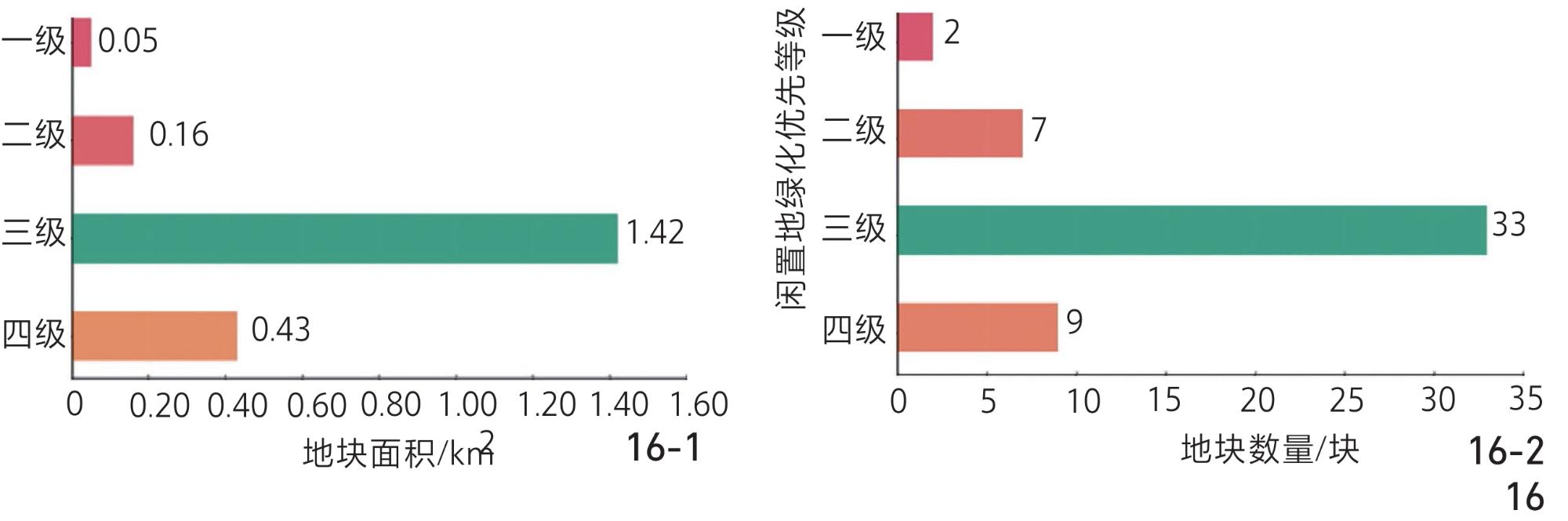
研究发现:1)研究区共识别出16条540 m宽的一级热岛廊道、42条150 m宽的二级热岛廊道,以及18处热岛夹点;2)现有228块闲置地中,21块闲置地位于一级廊道范围内,其中2块与热岛夹点直接相交,37块闲置地位于二级廊道范围内,表明闲置地的空间分布与热岛网络的关键结构存在显著关联;3)闲置地绿化改造应按“一级廊道与热岛夹点相交优效地块—一级廊道相交优效地块—二级廊道相交优效地块”三级优先序推进,以精准阻断热量传输并提升城市热环境韧性。
研究结果可为高密度建成区在用地约束下的热环境改善与精准绿化干预提供方法支撑与决策依据。
徐宁 , 樊澄珉 , 王璞 . 基于热岛网络的城市闲置地绿化潜力评估——以杭州市核心城区为例[J]. 风景园林, 2026 , 33(4) : 91 -101 . DOI: 10.3724/j.fjyl.LA20250505
Amid global climate change and rapid urbanization, the heat island effect has emerged as a major challenge in urban environments. In densely built-up areas, high population concentration and reduction of green spaces contribute to the gradual merging of heat island areas, forming a networked structure that intensifies thermal environmental risks. Small-scale green spaces are vital resources for disrupting the connectivity of heat island sources and regulating the local climate, offering additional opportunities for optimizing the urban thermal environment pattern. However, in central urban areas where land resources are scarce and competition for land use is intense, creating large-scale new green spaces remains challenging. In this context, several key scientific questions remain unresolved: How does the spatial connectivity of heat island sources form and influence the urban thermal environment? Is there a structural correlation between the distribution of vacant land and the heat island network? How can we scientifically determine the greening priority of vacant land to effectively mitigate the heat island effect? To address these issues, this study analyzed the spatial distribution of vacant land within the urban thermal environment, assessed its greening potential, reasonably established the priority of conversion to green spaces, and proposed a phased implementation strategy, thereby providing a scientific basis for mitigating the urban heat island effect and optimizing the spatial pattern of green spaces.
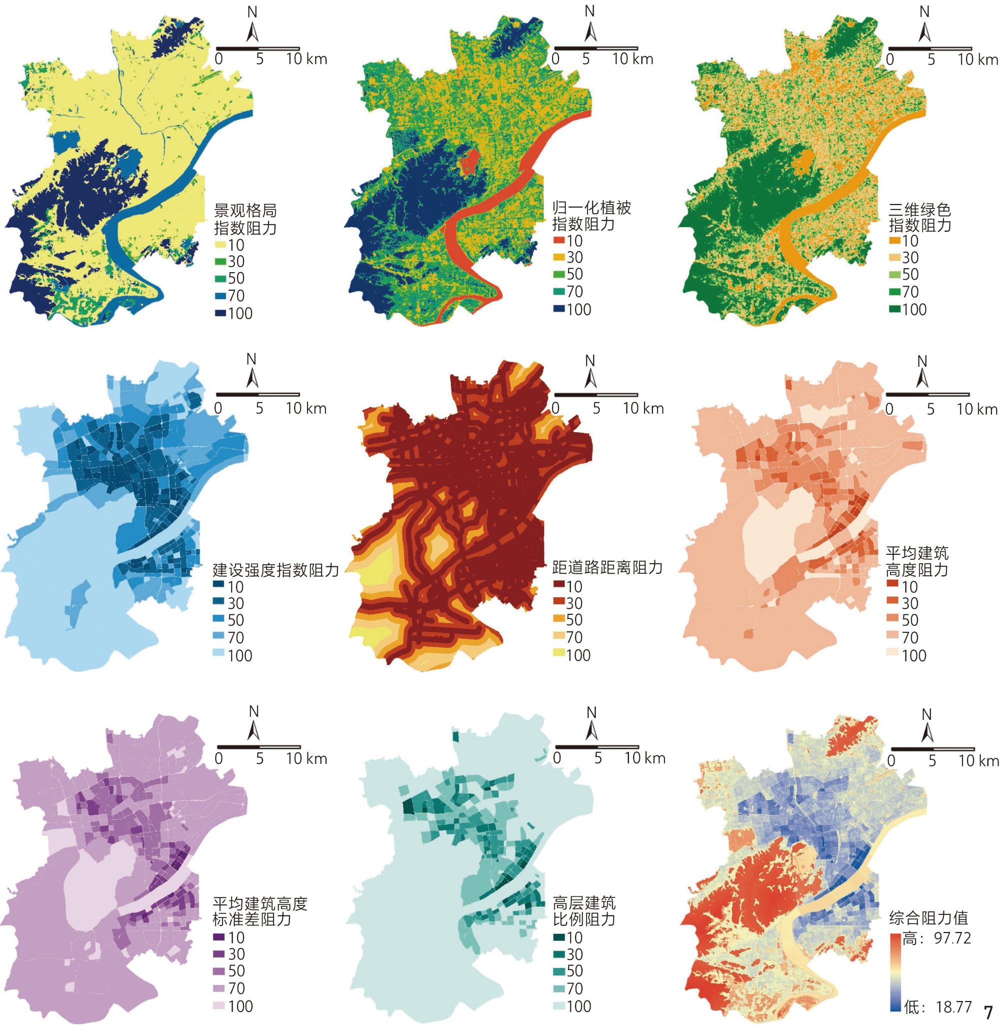
Focusing on the core urban area of Hangzhou (China) and comprehensively considering both two-dimensional and three-dimensional urban environmental characteristics, research was conducted to systematically construct an evaluation framework for assessing urban vacant land greening potential based on the heat island network using the circuit theory method. Key procedures included the following: 1) Obtaining spatial location information for vacant land within the study area and classifying it based on land cover characteristics. 2) Identifying the distribution of heat island sources through land surface temperature retrieval, combined with morphological spatial pattern analysis and thermal environment connectivity analysis. 3) Comprehensively selecting 15 urban environmental indicators (8 natural environment and 7 built environment indicators) incorporating two-dimensional and three-dimensional factors to construct a heat island resistance surface. 4) Building a heat island network based on circuit theory to precisely identify key nodes within the urban thermal environment network, revealing the spatial relationship between vacant land distribution and the heat island network. 5) Determining the priority hierarchy for converting vacant land into green spaces based on the structural characteristics of the heat island network and heat island corridor width. 6) Evaluating the potential value and opportunities of vacant land in optimizing the urban thermal environment pattern and mitigating the heat island effect.
The following results were derived: 1) A total of 16 primary heat island corridors with width of 540 m and length of 7.34 km, 42 secondary heat island corridors with width of 150 m and total length of 169.68 km, and 18 heat island pinch points with a total area of 0.65 km2 were identified within the study area. 2) Among the 228 vacant land parcels, 21 are located within the primary heat island corridors, with 2 directly intersecting heat island pinch points. Additionally, 37 are located within the secondary corridors. This distribution indicates an important spatial association between the vacant land and key structures within the heat island network. 3) The greening reconstruction of vacant land should be prioritized in three stages: first, “high-efficiency conversion parcels intersecting with primary heat island corridors and heat island pinch points,” followed by “high-efficiency conversion parcels intersecting with primary heat island corridors,” and finally, “high-efficiency conversion parcels intersecting with secondary heat island corridors.” This phased approach effectively blocks heat transfer and enhances the resilience of the urban thermal environment. 4) Based on the above results, this study further proposed the following gradient renewal pathway for vacant land. Transform the spatial association between vacant land and the heat island network into opportunities for ecological restoration, implement “targeted rescue” for 9 vacant land parcels within the core area that intersect with primary corridors, and carry out “batch restoration” for 33 vacant land parcels in peripheral areas intersecting with secondary corridors. This approach achieves precise allocation and efficient utilization of ecological resources and allows the remaining 186 vacant land parcels to be used for urban redevelopment purposes to balance land use costs.
The evaluation framework developed in this study provides methodological support and decision-making reference for improving the thermal environment and implementing precise greening interventions in high-density built-up areas facing land use constraints. By innovatively integrate both two-dimensional and three-dimensional environmental factors in the construction of the heat island resistance surface, and applying smooth curve fitting alongside threshold effect analysis to measure the width of heat island corridors, the spatial simulation accuracy of the urban heat diffusion process is substantially improved. Furthermore, incorporating the cost of vacant land reconstruction into the evaluation helps comprehensively balance the social, economic, and environmental benefits associated with vacant land reuse.
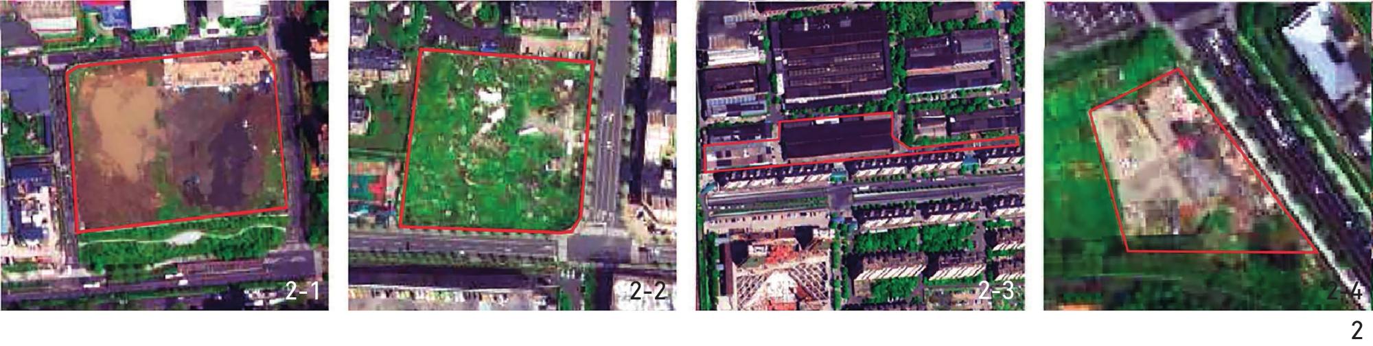
表1 城市闲置地的分类和特征Tab. 1 Classification and characteristics of urban vacant land |
| 类别 | 子类别 | 土地覆盖特征 |
|---|---|---|
| 透水型 闲置地 | 裸土类 | 未利用、低效利用的社区裸土空地 |
| 更新过程中未动工开发的裸露地块 | ||
| 自然类 | 无人维护、低使用率、表面杂草丛生的土地 | |
| 道路沿线低效利用绿地 | ||
| 不透水型 闲置地 | 建筑类 | 废弃的工业厂区及附属用地 |
| 原有建筑已拆除但未重建的荒置地块 | ||
| 已开工但因各种原因停滞的城市更新地块 | ||
| 硬质类 | 临时堆放杂物、低效利用的社区边角空地 |
表2 研究区内各类城市闲置地统计结果Tab. 2 Statistics of urban vacant land categories in the study area |
| 用地类型 | 数量 | 数量比/% | 面积/km2 | 面积比/% | |
|---|---|---|---|---|---|
| 透水型 闲置地 | 裸土类 闲置地 | 49 | 21.49 | 1.50 | 20.66 |
| 自然类 闲置地 | 139 | 60.97 | 4.80 | 66.12 | |
| 不透水型 闲置地 | 建筑类 闲置地 | 13 | 5.70 | 0.39 | 5.37 |
| 硬质类 闲置地 | 27 | 11.84 | 0.57 | 7.85 | |
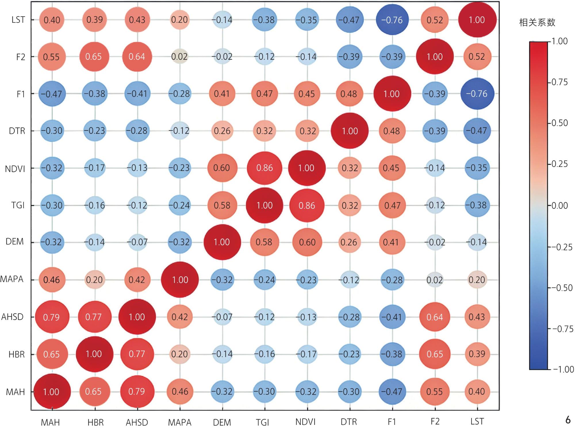
表3 主成分指标及其子指标的归一化系数Tab. 3 Normalized coefficients of principal components and their sub-indicators |
| 主成分指标 | 主成分子指标 | 归一化系数 |
|---|---|---|
| F1 | LSI | 0.191 1 |
| SHDI | 0.230 8 | |
| PD | 0.115 3 | |
| CONTAG | 0.230 8 | |
| LU | 0.232 0 | |
| F2 | BCR | 0.454 5 |
| FAR | 0.545 5 |
表4 热岛阻力面各指标权重统计Tab. 4 Statistics of indicator weights for UHI resistance surface |
| 指标 | 权重 | |
|---|---|---|
| 注:a)分为林地、水体、草地、裸地和建设用地5类。 | ||
| F1 | LSI | |
| SHDI | ||
| PD | ||
| CONTAG | ||
| LUa) | ||
| F2 | BCR | |
| FAR | ||
| NDVI | ||
| TGI | ||
| DTR | ||
| MAH | ||
| AHSD | ||
| HBR | ||
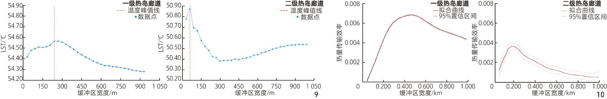
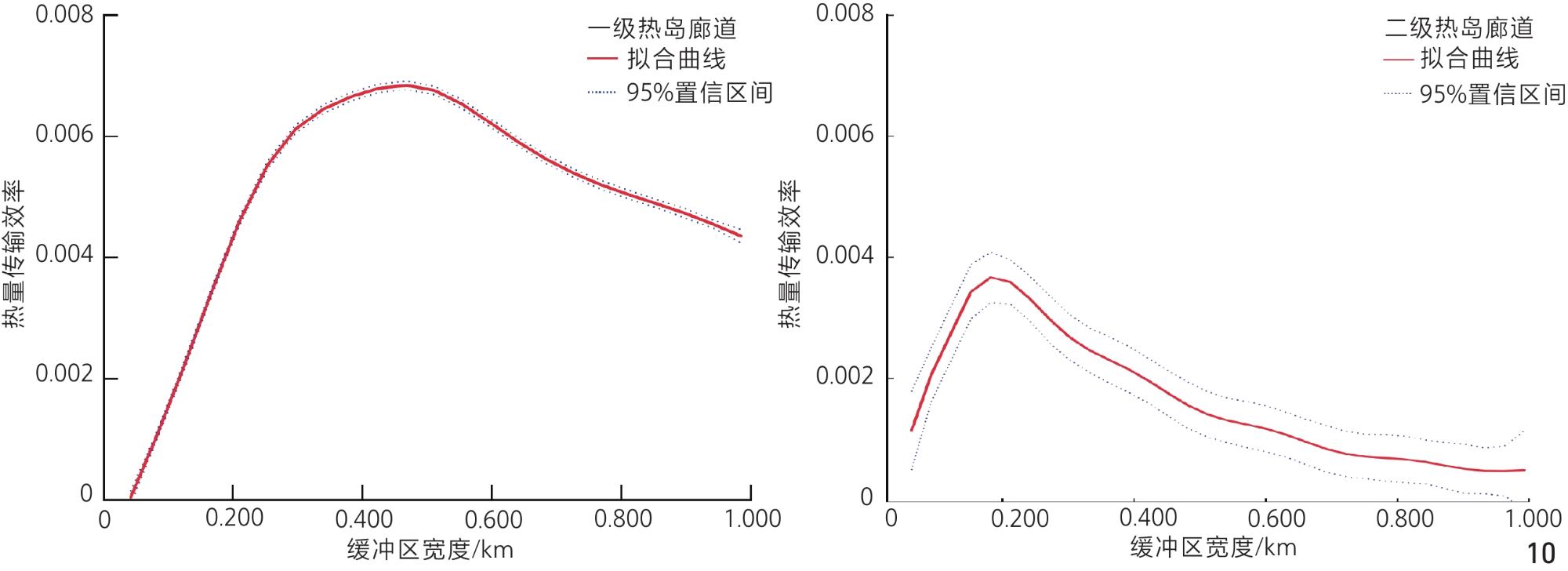
图10 热岛廊道热量传输效率与缓冲区宽度的关系曲线Fig. 10 Relationship between heating efficiency and width of buffer zone |
表5 基于两段式线性回归模型的热岛廊道拐点检测结果Tab. 5 UHI corridor infection point detection for two-piecewise linear regression model |
| 拐点距离/km | 效应量 ( | 95%置信区间 | p值 | |
|---|---|---|---|---|
| 一级 热岛 廊道 | <0.54 | 0.033 3 | 0.031 2~0.035 4 | <0.001 |
| ≥0.54 | −0.006 3 | −0.007 2~−0.005 4 | <0.001 | |
| 二级 热岛 廊道 | <0.15 | 0.023 7 | 0.014 0~0.033 4 | <0.001 |
| ≥0.15 | −0.003 9 | −0.004 6~−0.003 3 | <0.001 | |
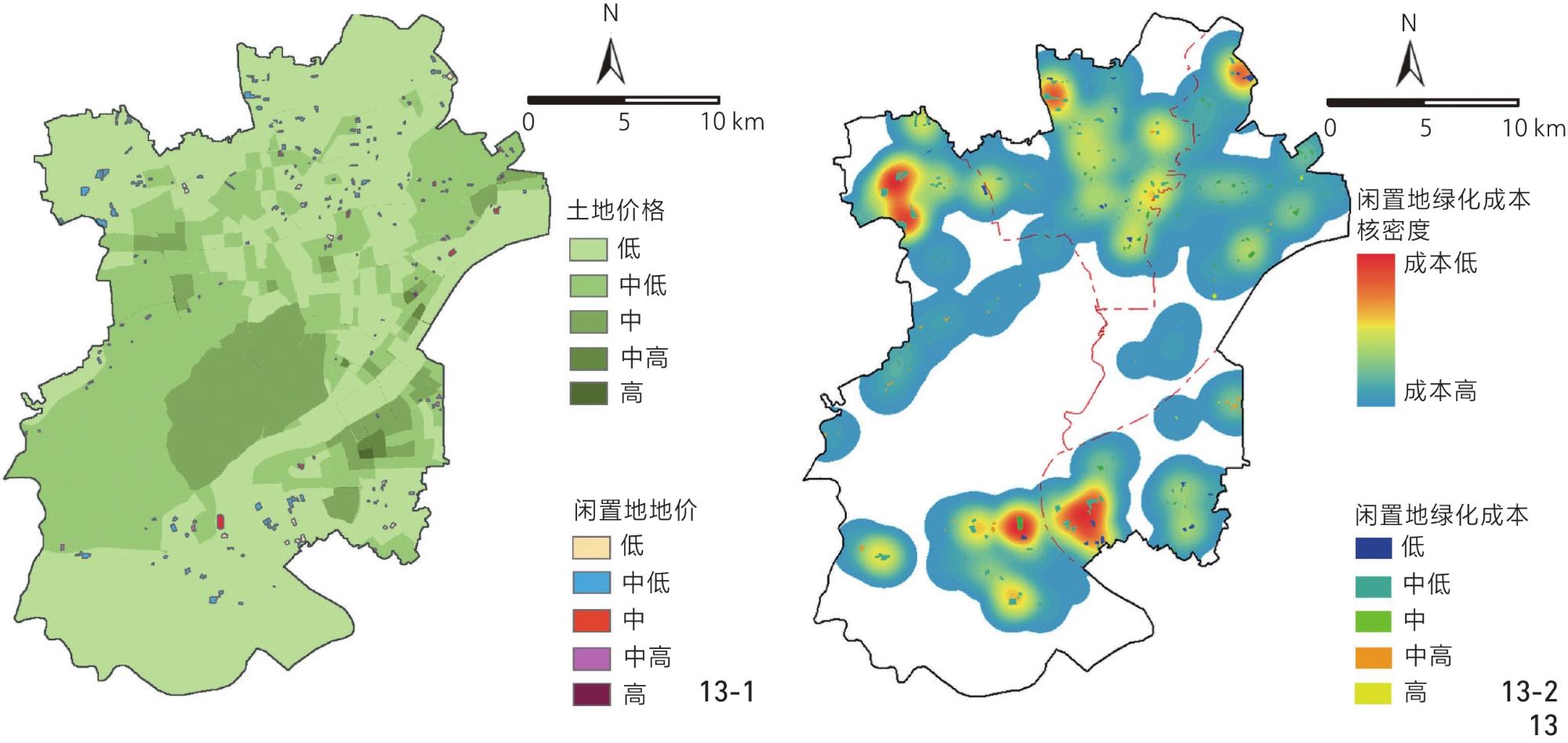
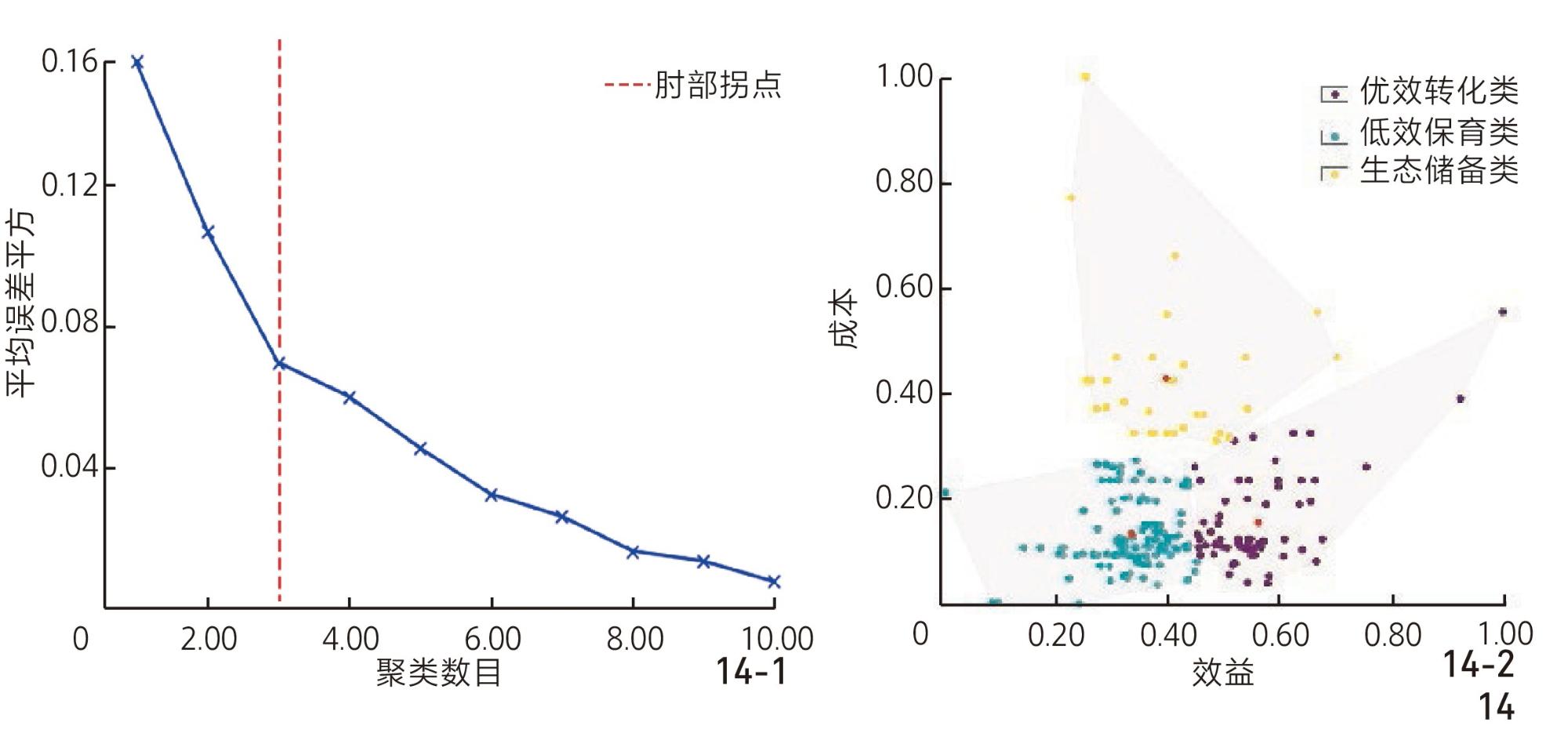
文中图片均由作者绘制,其中图1、
1、突破既有二维框架,纳入三维阻力面和热量传输阈值分析,更真实模拟高密度城市环境下的热量聚集与流动过程。
2、基于平滑曲线拟合与阈值效应分析,精准识别出研究区分布的16条540 m宽的一级热岛廊道、42条150 m宽的二级热岛廊道,以及18处热岛夹点。
3、发现研究区闲置地空间分布与热岛网络的关键结构存在显著关联,闲置地绿化改造应按“一级廊道与热岛夹点相交优效地块—一级廊道相交优效地块—二级廊道相交优效地块”三级优先序推进。
| [1] |
吴菲, 李树华, 刘娇妹. 城市绿地面积与温湿效益之间关系的研究[J]. 中国园林, 2007, 23(6): 71-74.
WU F, LI S H, LIU J M. Research on the Relationship Between Urban Green Spaces of Different Areas and the Temperature and Humidity Benefit[J]. Chinese Landscape Architecture, 2007, 23(6): 71-74.
|
| [2] |
ZHOU W Q, WANG J, CADENASSO M L. Effects of the Spatial Configuration of Trees on Urban Heat Mitigation: A Comparative Study[J]. Remote Sensing of Environment, 2017, 195, 1-12.
|
| [3] |
SILVEIRA C, DIAS A T C, AMARAL F G, et al. The Importance of Private Gardens and Their Spatial Composition and Configuration to Urban Heat Island Mitigation[J]. Sustainable Cities and Society, 2024, 112: 105589.
|
| [4] |
NÉMETH J, LANGHORST J. Rethinking Urban Transformation: Temporary Uses for Vacant Land[J]. Cities, 2014, 40, 143-150.
|
| [5] |
GALEN NEWMAN L D. Resilience Through Regeneration: The Economics of Repurposing Vacant Land with Green Infrastructure[J]. Landscape Architecture Frontiers, 2018, 6(6): 10-23.
|
| [6] |
SUN H, LIU C H, WEI J X. Identifying Key Sites of Green Infrastructure to Support Ecological Restoration in the Urban Agglomeration[J]. Land, 2021, 10(11): 1196.
|
| [7] |
陈静, 纪丹雯, 肖扬, 等. 生物多样性视角下城市闲置地的微更新探索: 以临时社区花园为例[J]. 中国园林, 2019, 35(12): 28-33.
CHEN J, JI D W, XIAO Y, et al. Micro-Renewal Exploration of Urban Vacant Lots from the Perspective of Biodiversity: Taking Temporary Community Garden as the Example[J]. Chinese Landscape Architecture, 2019, 35(12): 28-33.
|
| [8] |
XU S J, EHLERS M. Automatic Detection of Urban Vacant Land: An Open-Source Approach for Sustainable Cities[J]. Computers, Environment and Urban Systems, 2022, 91: 101729.
|
| [9] |
JACKSON K T, FRONTIER C. Crabgrass Frontier: The Suburbanization of the United States[M]. NewYork: Oxford University Press, 1985: 31-35.
|
| [10] |
KIM G, MILLER P A, NOWAK D J. Urban Vacant Land Typology: A Tool for Managing Urban Vacant Land[J]. Sustainable Cities and Society, 2018, 36, 144-156.
|
| [11] |
KIM G, MILLER P A, NOWAK D J. Assessing Urban Vacant Land Ecosystem Services: Urban Vacant Land as Green Infrastructure in the City of Roanoke, Virginia[J]. Urban Forestry & Urban Greening, 2015, 14(3): 519-526.
|
| [12] |
NOH Y. Does Converting Abandoned Railways to Greenways Impact Neighboring Housing Prices?[J]. Landscape and Urban Planning, 2019, 183, 157-166.
|
| [13] |
Urban Heat Island Basics. Reducing Urban Heat Islands: Compendium of Strategies[EB/OL]. [2011-01-14]. http://www. epa. gov/heatisland/resources/compendium.htm.
|
| [14] |
周盼, 吴佳雨, 吴雪飞. 基于绿色基础设施建设的收缩城市更新策略研究[J]. 国际城市规划, 2017, 32(1): 91-98.
ZHOU P, WU J Y, WU X F. Research on Shrinking Cities’ Renewal Strategy Based on Green Infrastructure Construction[J]. Urban Planning International, 2017, 32(1): 91-98.
|
| [15] |
KREMER P, HAMSTEAD Z A, MCPHEARSON T. A Social−Ecological Assessment of Vacant Lots in New York City[J]. Landscape and Urban Planning, 2013, 120, 218-233.
|
| [16] |
MCPHEARSON T, KREMER P, HAMSTEAD Z A. Mapping Ecosystem Services in New York City: Applying a Social−Ecological Approach in Urban Vacant Land[J]. Ecosystem Services, 2013, 5, 11-26.
|
| [17] |
ZHANG P, FAHEY R T, PARK S. The Importance of Current and Potential Tree Canopy on Urban Vacant Lots for Landscape Connectivity[J]. Urban Forestry & Urban Greening, 2024, 94: 128235.
|
| [18] |
NEWMAN G D, SMITH A L, BRODY S D. Repurposing Vacant Land Through Landscape Connectivity[J]. Landscape Journal, 2017, 36(1): 37-57.
|
| [19] |
WOLFF M, HAASE D, PRIESS J, et al. The Role of Brownfields and Their Revitalisation for the Functional Connectivity of the Urban Tree System in a Regrowing City[J]. Land, 2023, 12(2): 333.
|
| [20] |
李佳杰, 顾媛媛, 邢忠. 武汉城市圈“生物迁移-区域降温”复合功能生态网络构建[J]. 风景园林, 2025, 32(1): 96-104.
LI J J, GU Y Y, XING Z. Construction of “Biomigration−Regional Cooling” Multi-functional Ecological Network in Wuhan Urban Agglomeration[J]. Landscape Architecture, 2025, 32(1): 96-104.
|
| [21] |
LI Y Y, WANG S M, ZHANG S J, et al. The Creation of Multi-level Urban Ecological Cooling Network to Alleviate the Urban Heat Island Effect[J]. Sustainable Cities and Society, 2024, 114: 105786.
|
| [22] |
张文萍, 庄子薛, 谢梦晴, 等. 基于电路理论的多尺度城市热环境网络构建及格局优化: 以成都市中心城区为例[J]. 中国园林, 2023, 39(4): 103-108.
ZHANG W P, ZHUANG Z X, XIE M Q, et al. Construction and Pattern Optimization of Multiscale Urban Thermal Environment Network Based on Circuit Theory: A Case Study of the Central Urban Area of Chengdu[J]. Chinese Landscape Architecture, 2023, 39(4): 103-108.
|
| [23] |
李佳杰, 邢忠, 李旭. 基于电路理论的城市高温控制优先区域识别: 以重庆市中心城区为例[J]. 中国园林, 2024, 40(11): 97-103.
LI J J, XING Z, LI X. Identification of Priority Areas for Urban Heat Mitigation Based on Circuit Theory: A Case Study of Chongqing’s Central City[J]. Chinese Landscape Architecture, 2024, 40(11): 97-103.
|
| [24] |
费凡, 尹海伟, 孔繁花, 等. 基于二维与三维信息的南京市主城区生态网络格局对比分析[J]. 生态学报, 2020, 40(16): 5534-5545.
FEI F, YIN H W, KONG F H, et al. Comparative Analysis of Ecological Network Pattern Using 2D and 3D Information in Main Urban Area of Nanjing, China[J]. Acta Ecologica Sinica, 2020, 40(16): 5534-5545.
|
| [25] |
TRAVERS E, HÄRDTLE W, MATTHIES D. Corridors as a Tool for Linking Habitats: Shortcomings and Perspectives for Plant Conservation[J]. Journal for Nature Conservation, 2021, 60: 125974.
|
| [26] |
JIMÉNEZ-MUÑOZ J C, SOBRINO J A, SKOKOVIĆ D, et al. Land Surface Temperature Retrieval Methods from Landsat-8 Thermal Infrared Sensor Data[J]. IEEE Geoscience and Remote Sensing Letters, 2014, 11(10): 1840-1843.
|
| [27] |
RENC A, ŁUPIKASZA E, BŁASZCZYK M. Spatial Structure of the Surface Heat and Cold Islands in Summer Based on Landsat 8 Imagery in Southern Poland[J]. Ecological Indicators, 2022, 142: 109181.
|
| [28] |
XIANG Y, CEN Q Y, PENG C C, et al. Surface Urban Heat Island Mitigation Network Construction Utilizing Source-Sink Theory and Local Climate Zones[J]. Building and Environment, 2023, 243: 110717.
|
| [29] |
KOEN E L, BOWMAN J, SADOWSKI C, et al. Landscape Connectivity for Wildlife: Development and Validation of Multispecies Linkage Maps[J]. Methods in Ecology and Evolution, 2014, 5(7): 626-633.
|
| [30] |
HAN S J, HOU H, ESTOQUE R C, et al. Seasonal Effects of Urban Morphology on Land Surface Temperature in a Three-Dimensional Perspective: A Case Study in Hangzhou, China[J]. Building and Environment, 2023, 228: 109913.
|
| [31] |
白晓琼, 王汶, 林子彦, 等. 基于高空间分辨率遥感影像的三维绿度度量[J]. 国土资源遥感, 2019, 31(4): 53-59.
BAI X Q, WANG W, LIN Z Y, et al. Three-Dimensional Measuring for Green Space Based on High Spatial Resolution Remote Sensing Images[J]. Remote Sensing for Land & Resources, 2019, 31(4): 53-59.
|
| [32] |
YU Z W, ZHANG J G, YANG G Y. How to Build a Heat Network to Alleviate Surface Heat Island Effect?[J]. Sustainable Cities and Society, 2021, 74: 103135.
|
| [33] |
张浪, 余浩然, 仲启铖, 等. 基于功能连接度的城市生态廊道空间范围划定研究[J]. 中国园林, 2024, 40(4): 6-14.
ZHANG L, YU H R, ZHONG Q C, et al. Research on the Spatial Demarcation of Urban Ecological Corridors Based on Functional Connectivity[J]. Chinese Landscape Architecture, 2024, 40(4): 6-14.
|
| [34] |
LUO J L, FU H. Constructing an Urban Cooling Network Based on PLUS Model: Implications for Future Urban Planning[J]. Ecological Indicators, 2023, 154: 110887.
|
| [35] |
PERINI K, MAGLIOCCO A. Effects of Vegetation, Urban Density, Building Height, and Atmospheric Conditions on Local Temperatures and Thermal Comfort[J]. Urban Forestry & Urban Greening, 2014, 13(3): 495-506.
|
| [36] |
KIM J, KHOUAKHI A, CORSTANJE R, et al. Greater Local Cooling Effects of Trees Across Globally Distributed Urban Green Spaces[J]. Science of the Total Environment, 2024, 911: 168494.
|
| [37] |
LUO J L, ZHU L, FU H. A New Framework for Mitigating Urban Heat Island Effect from the Perspective of Network[J]. Ecological Indicators, 2025, 170: 113059.
|
/
| 〈 |
|
〉 |