
天津市内六区自然与文化遗产整体保护空间网络构建
|
张春彦/男/博士/天津大学建筑学院书记、教授、博士生导师/本刊编委/研究方向为风景园林历史与理论、风景园林文化遗产保护 |
|
张新翊/女/天津大学建筑学院在读博士研究生/研究方向为风景园林文化遗产保护 |
|
何严松/男/天津大学建筑学院在读博士研究生/研究方向为风景园林文化遗产保护 |
Copy editor: 刘颖
收稿日期: 2025-10-31
修回日期: 2026-03-14
网络出版日期: 2026-04-22
基金资助
国家社会科学基金重点项目(社团项目)“文化遗产整体性保护体系的理论建构与实践路径研究”(25SGB011)
天津市哲学社会科学规划项目重点项目“津派建筑文化研究”(TJJWZD04-02)
Establishing a Holistic Protection Spatial Network for Natural and Cultural Heritage in the Six Central Districts of Tianjin
|
ZHANG Chunyan, Ph.D., is secretary of, a professor and doctoral supervisor in the School of Architecture, Tianjin University, and an editorial board of this journal. His research focuses on history and theory of landscape architecture, and landscape culture heritage protection |
|
ZHANG Xinyi is a Ph.D. candidate in the School of Architecture, Tianjin University. Her research focuses on landscape culture heritage protection |
|
HE Yansong is a Ph.D. candidate in the School of Architecture, Tianjin University. His research focuses on landscape culture heritage protection |
Received date: 2025-10-31
Revised date: 2026-03-14
Online published: 2026-04-22
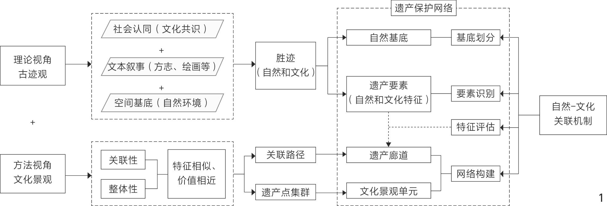
构建天津市内六区自然与文化遗产整体保护空间网络(简称遗产保护网络),破解现有自然与文化保护分离的困境,为区域遗产的协同治理提供科学决策支撑。
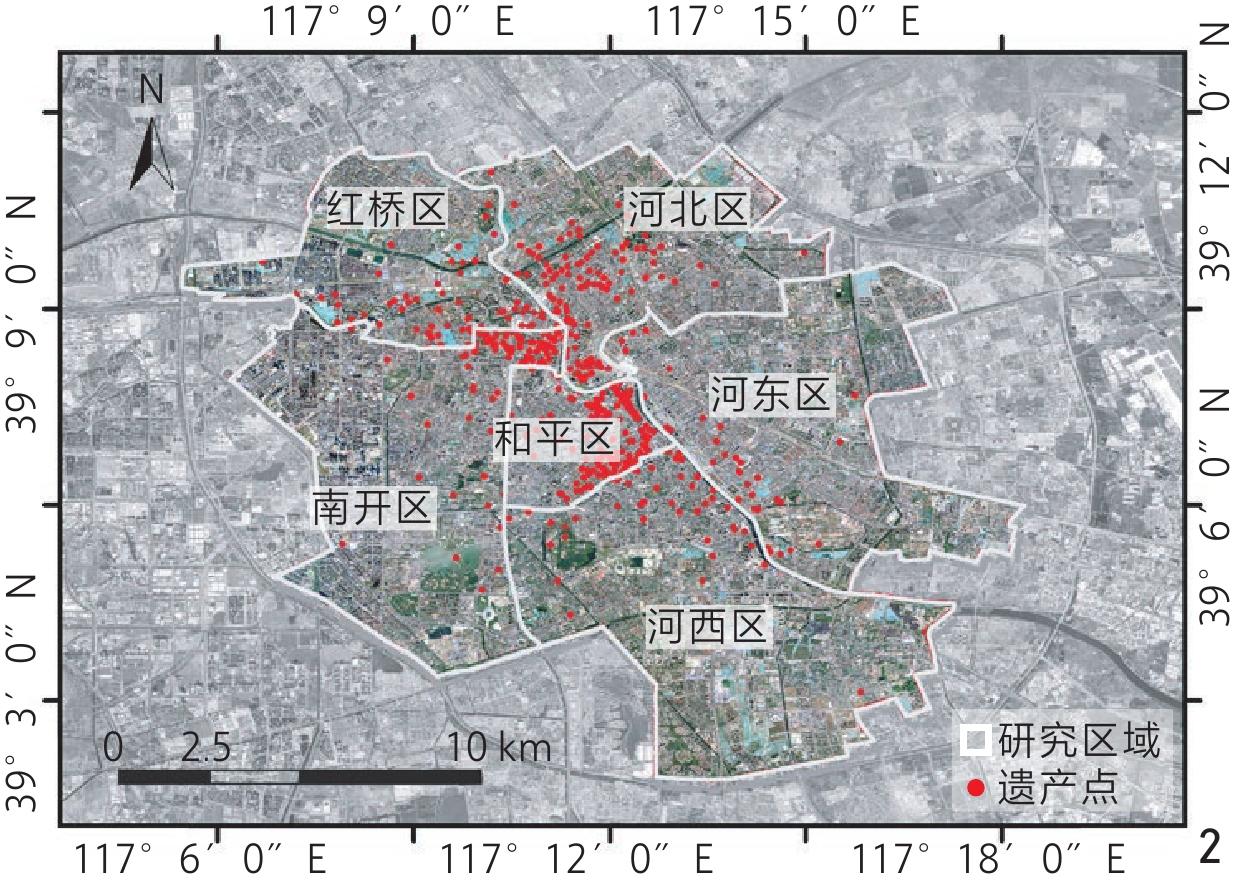
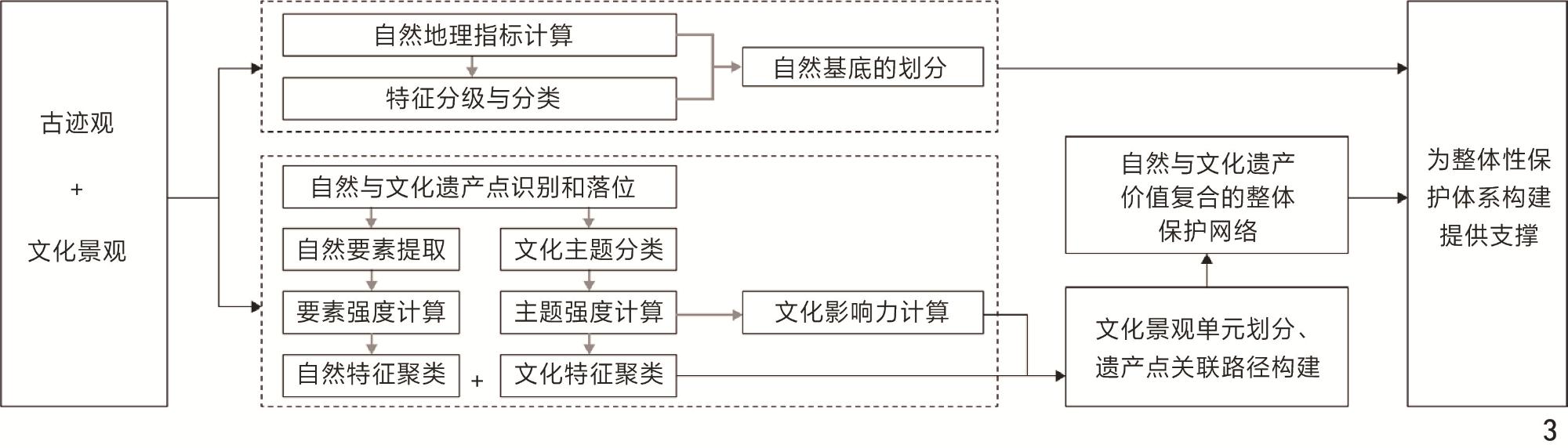
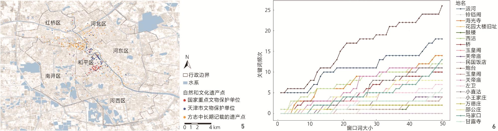
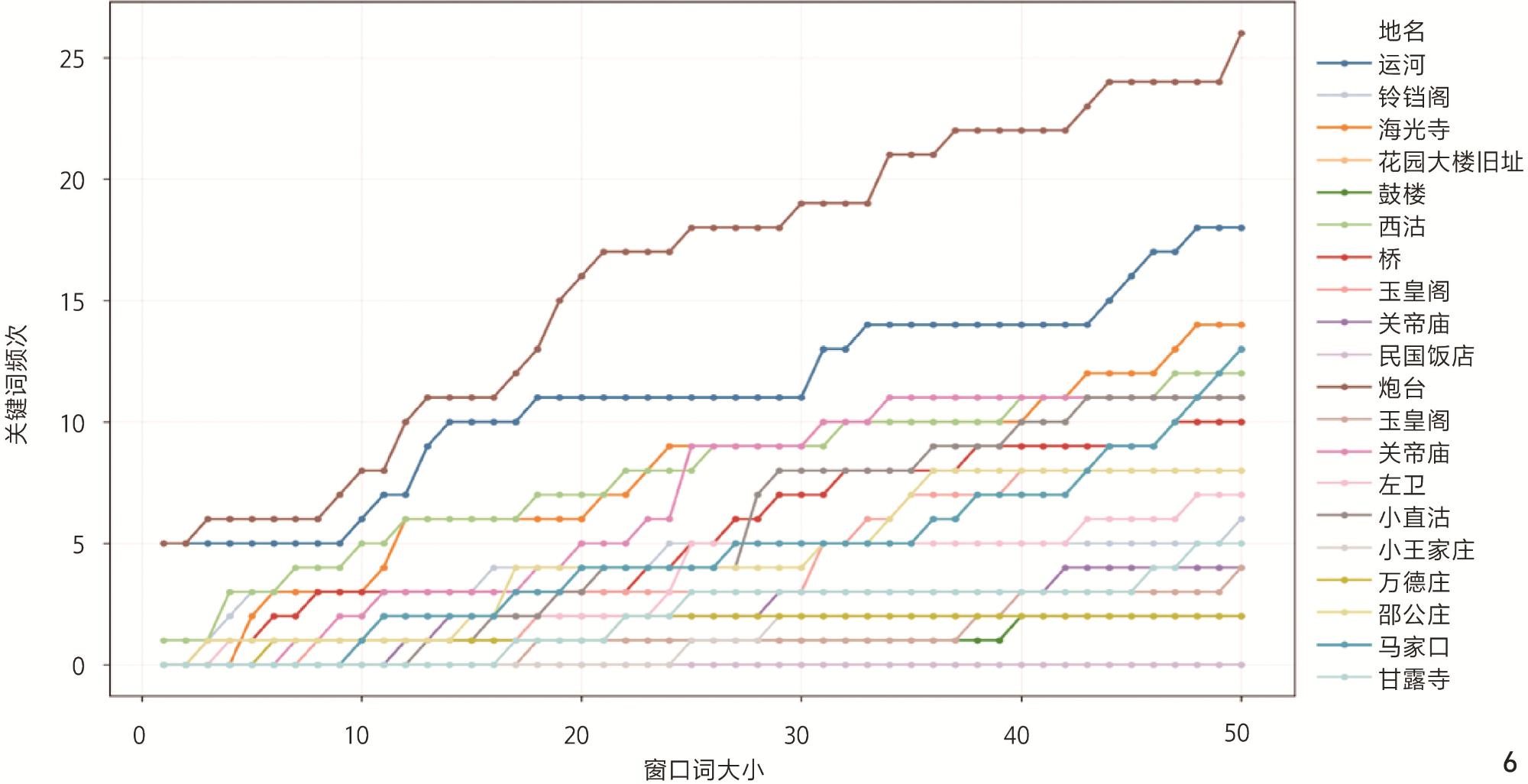
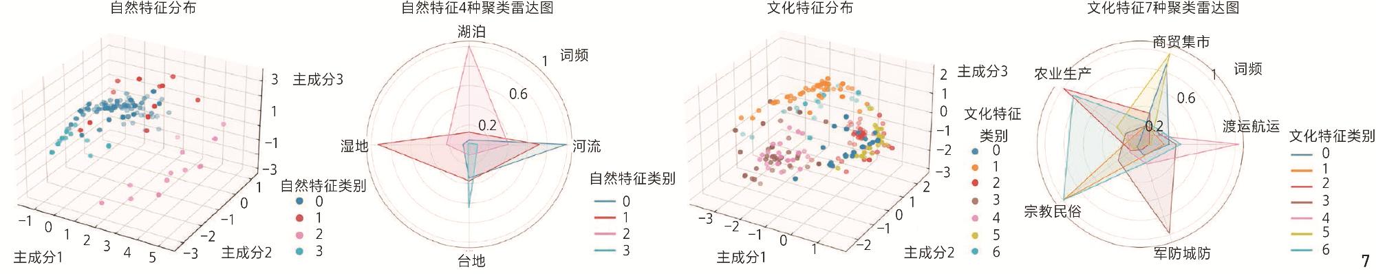
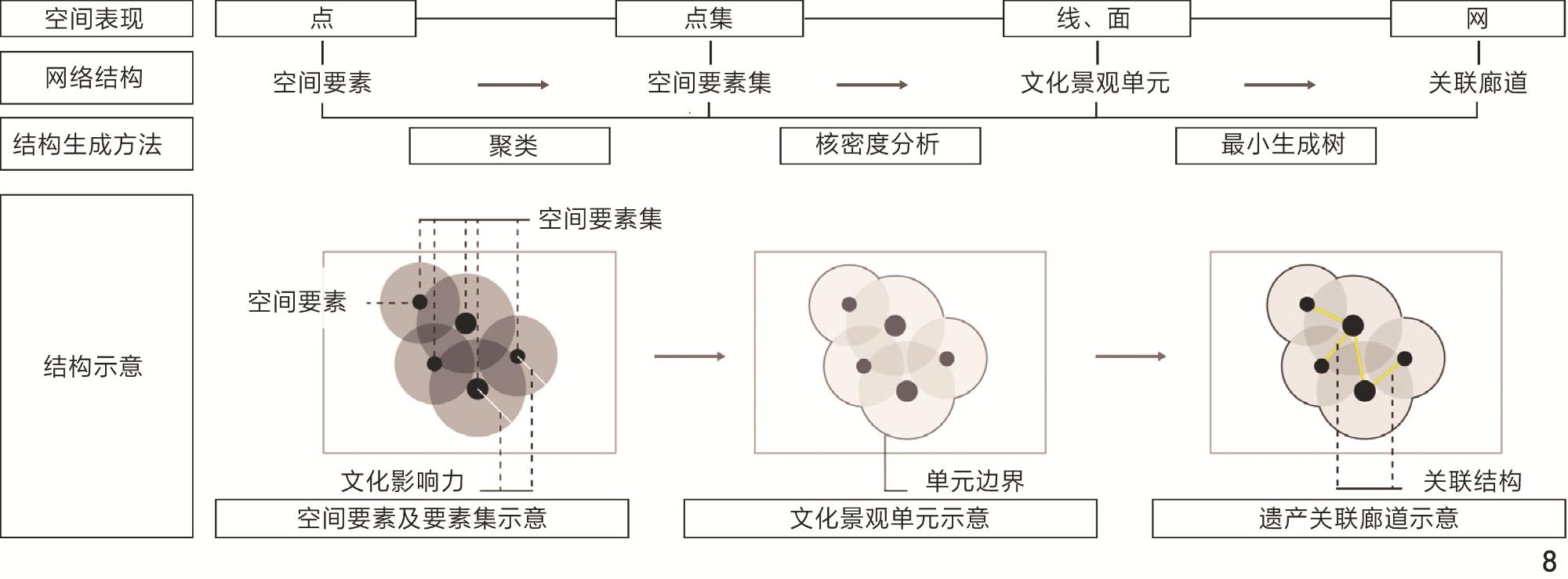
以天津市内六区为例,基于自然-文化关联机制,结合文本、图像、地理空间多源数据,综合运用GIS空间分析、主成分分析(principal component analysis, PCA)与高斯混合模型(Gaussian mixture model, GMM)组合的PAC-GMM聚类、核密度估计与最小生成树模型,识别市内六区自然与文化遗产空间要素,量化空间要素的自然与文化特征及关联性,并以此为依据构建遗产保护网络。
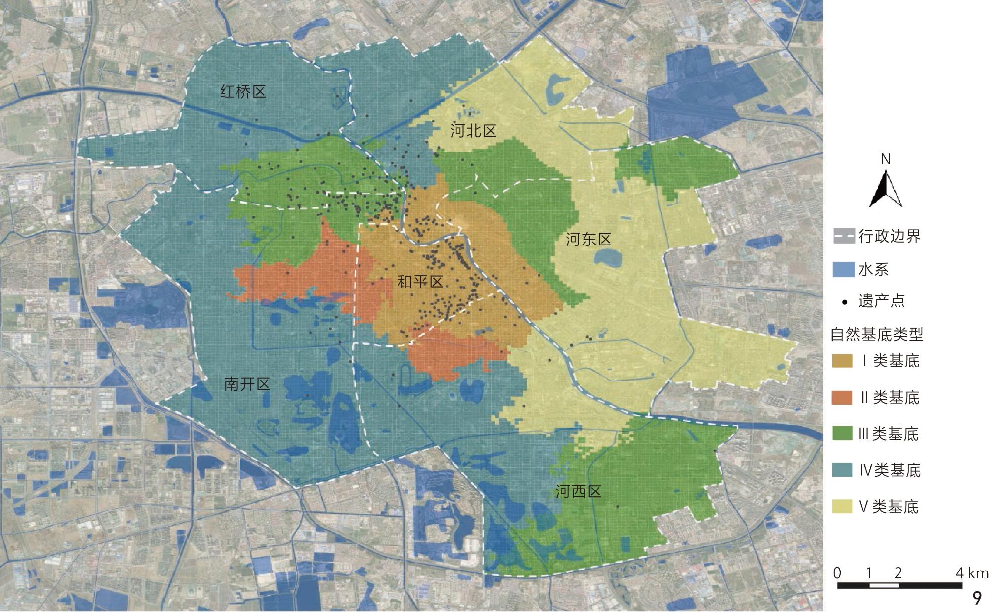
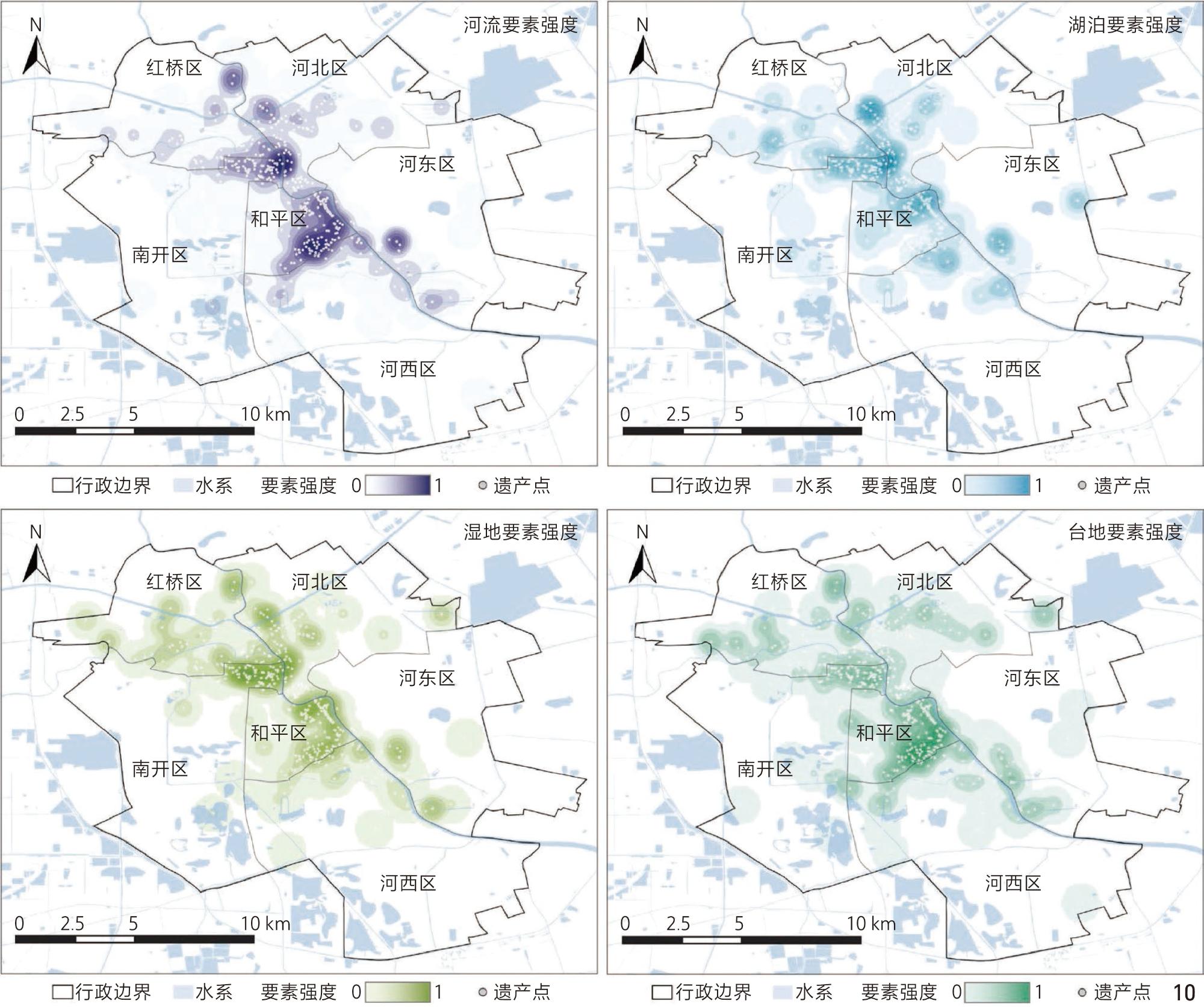
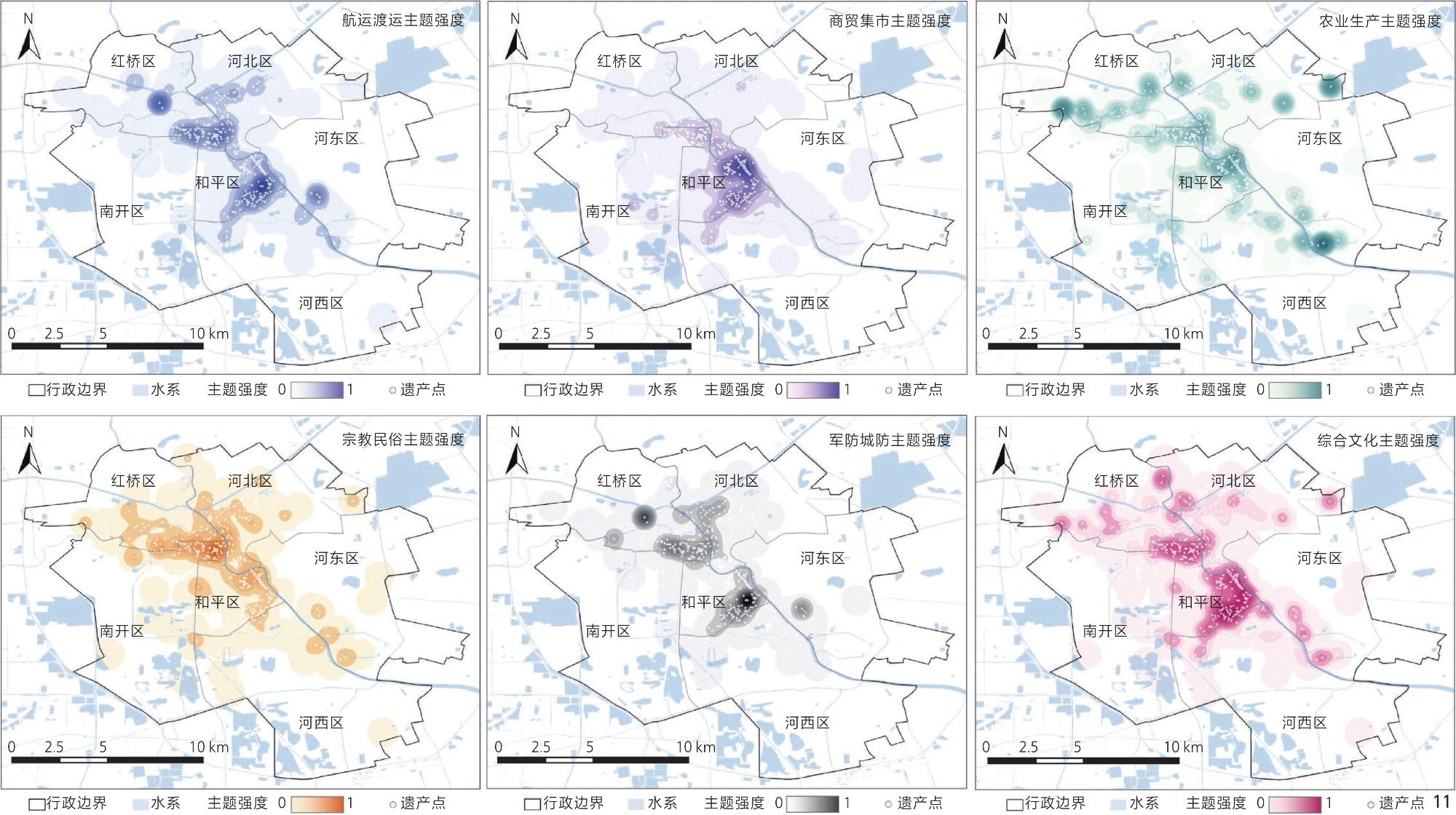
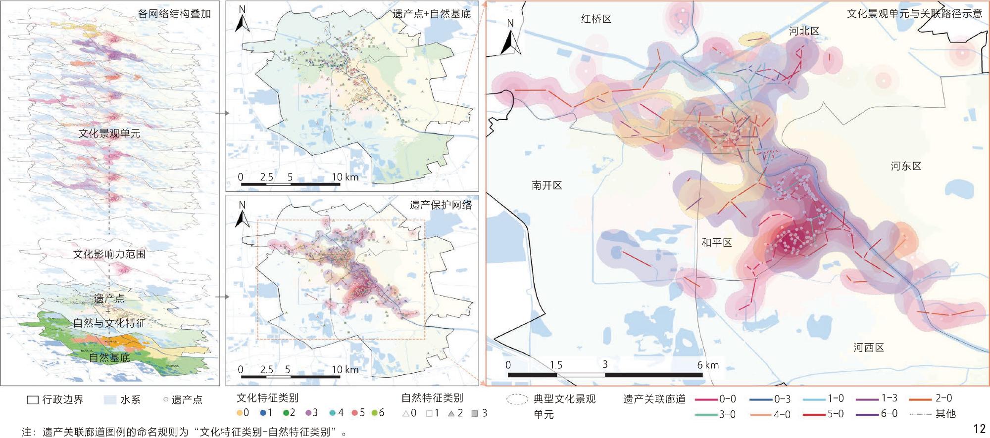
天津市内六区遗产保护网络中共识别重要遗产点458个,依据地形地貌、水文条件、气候特征、植被土壤4类自然地理指标划分5类自然基底。同时,总结渡运航运、商贸集市、农业生产、宗教民俗和军防城防5个文化主题与河流、湖泊、湿地、台地4种自然要素。最终,聚类7种文化特征与4类自然特征,划分典型文化景观单元9个,构建空间关联路径311条。
从理论和方法2个维度,在中国传统古迹观与文化景观理论视角下构建遗产保护网络,推动自然与文化遗产价值复合的整体保护与协同治理。
张春彦 , 张新翊 , 何严松 . 天津市内六区自然与文化遗产整体保护空间网络构建[J]. 风景园林, 2026 , 33(4) : 39 -49 . DOI: 10.3724/j.fjyl.LA20250683
Aiming at the problems of separation and inadequate integration between natural and cultural heritage protection in current territorial spatial planning, this study aims to construct a regional heritage holistic protection spatial network that integrates natural and cultural values. Taking the six central districts of Tianjin as an example, this research explores a systematic approach that integrates local theories, historical documents, and multi-source spatial data to identify heritage elements, quantify their natural and cultural associations, and ultimately form a spatial structure that supports collaborative governance and planning optimization, providing a solution to break the protection dilemma of the natural-cultural dualistic division.
Based on the “nature-culture” linkage mechanism reflected in traditional GUJI concepts and cultural landscape theory, this study integrates textual, visual, and geospatial multi-source data to construct a technical framework of “text mining−feature quantification−network building.” The research data includes text data, map data, and spatial data.The research methods include: 1) Natural base classification: Based on four types of indicators—terrain, hydrological conditions, climate features, and vegetation/soil—100 m × 100 m grid analysis was applied. GIS spatial analysis was employed to delineated five types of natural substrates. 2) Natural and cultural feature identification: Natural elements (rivers, lakes, wetlands, terraces) and cultural themes (transportation and shipping, commercial markets, agricultural production, religion and folklore, military defense) surrounding heritage sites were extracted. Keyword matching and inverse term frequency co-occurrence were used to compute element intensity. 3) Feature clustering: Principal component analysis (PCA) and Gaussian mixture model (GMM) clustering were applied to identify four types of natural features and seven types of cultural features. 4) Cultural influence calculation: Kernel density estimation (KDE) was used to transform discrete heritage points into continuous density surfaces, quantifying the spatial influence ranges of the five cultural themes. 5) Network construction: Based on feature clustering results, cultural landscape units were delineated, and the minimum spanning tree (MST) algorithm was employed to construct heritage linkage corridors, forming an integrated “point-line-area” holistic conservation network.
The study identifies five types of natural bases, with significant micro-scale differentiation between the units of each base. Additionally, there are distinct functional differences in the heritage types supported by different natural bases. A macro understanding of the geographical features and hydrological conditions in the six districts of Tianjin, along with the spatial distribution of heritage sites, helps in developing preventive strategies based on the natural geographical features of each region in the protection planning. Through text mining, four natural elements and five cultural themes are identified. Clustering results in seven cultural features and four natural features. The cultural features show significant spatial differentiation: The transportation and shipping culture is distributed in a belt along the Haihe River, with the core concentrated around the Sancha River confluence; the commercial market culture exhibits a dual-core pattern (traditional center of the old city and the modern commercial belt of the foreign concessions); agricultural production culture is distributed as points on the periphery; religious and folklore culture is scattered along the old city streets; military defense culture is concentrated in city walls, garrisons, and river defense points. Among the natural elements, rivers are distributed in bands, wetlands are concentrated in waterfront areas, and terraces are distributed in the concentric areas and historical construction nodes such as ferry terminals. Ultimately, an integrated protection network was constructed, including nine typical cultural landscape units and 311 spatial association paths. The network is centered around the Haihe River confluence, radiating outward along the water system, presenting a “core concentration, peripheral diffusion” pattern. The association corridors are densely distributed from the Haihe River confluence to the core area of Heping District, extending radially along historical streets and water systems. This distribution reflects the spatial logic of religious folklore and commercial market cultures following the street axis, and the interaction between military defense and transportation cultures relying on waterways.
This study constructs an integrated conservation spatial network for natural and cultural heritage from a holistic perspective of nature-culture interactive symbiosis. Theoretically, it integrates the traditional Chinese concept of “Guji” with cultural landscape theory, proposing an analytical framework of “spatial substrate–textual narrative–social identity” to provide indigenous theoretical support for the cognition of “correlation” and “integrity” in natural and cultural heritage conservation. Methodologically, it establishes a technical route of “text mining–cluster analysis–geographic modeling–network analysis”, whose core lies in integrating multi-source heterogeneous historical materials (local gazetteers, historical maps) with contemporary geospatial data, revealing the spatial correlation and structural characteristics of “nature-culture” elements through quantitative models. The research findings supplement potential natural and cultural heritage and their interrelations, delineating the boundaries of cultural landscape units. The network clarifies the element composition and spatial scope of holistic conservation, providing a basis for constructing integrated conservation systems in current planning; the relational diagram among heritage points can serve as a “relational base map” for cross-departmental collaboration, promoting coordinated governance of heritage.
表1 数据来源及预处理Tab. 1 Data source and preprocessing |
| 类型 | 名称 | 年份 | 来源 | 预处理 |
|---|---|---|---|---|
| 文本数据 | 《天津卫志》 | 1678(清康熙十七年) | 国家图书馆数字资源平台(read.nlc.cn/user/index) | 对影像文本进行了光学字符识别处理,将原始图像转为文本格式。随后,进行繁转简的字体转化与基础校勘 |
| 《天津县志》 | 1739(清乾隆四年) | |||
| 《天津市概要》 | 1934 | |||
| 地图数据 | 《天津城厢保甲全图》 | 1899 | 现藏于美国国会图书馆 | 利用ArcGIS 10.7软件进行地图配准后,根据地图上的标注对历史空间初步落位 |
| 《1900年天津地图》 | 1900 | 现藏于欧洲文化图书馆 | ||
| 空间数据 | DEM(分辨率30 m) | 2019 | 国家地球系统科学与数据中心(www.geodata.cn) | 利用ArcGIS 10.7软件对数据进行批量投影、重分类和掩膜提取,统一投影坐标系。确定分类要素后,进一步叠加要素,并结合多光谱遥感影像数据进行校核修正 |
| 水系 | 2015 | |||
| 降水(分辨率1 km) | 2022 | 中国科学院资源环境数据中心(www.resdc.cn) | ||
| NDVI(分辨率30 m) | 2000 | |||
| 行政区划 | 2022 | 天津市民政部(mz.tj.gov.cn) | ||
| 国家级、市级文保单位 | 2024 | 天津市文化和旅游局(whly.tj.gov.cn/WSBSYZXBS4230) |
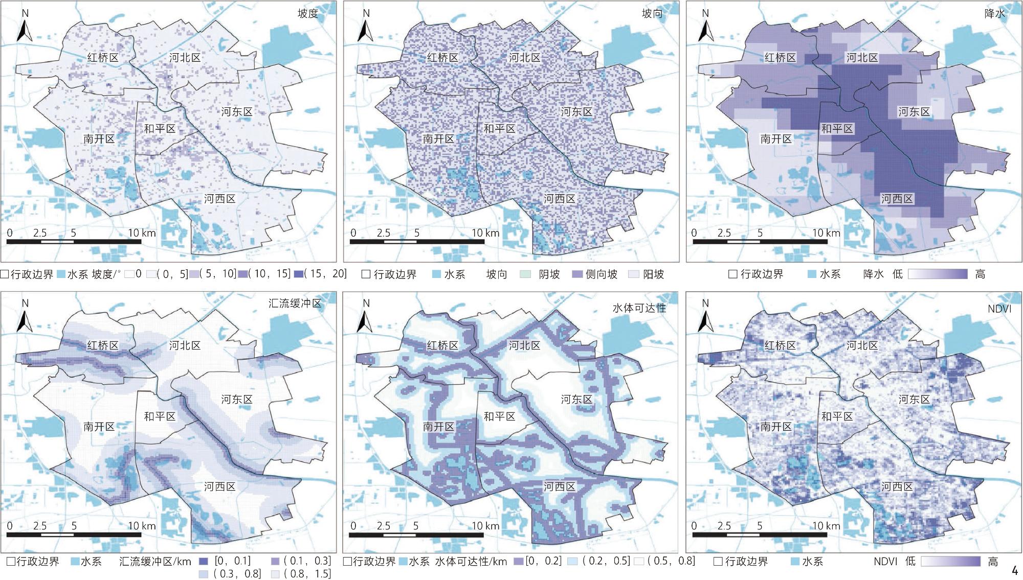
表2 自然基底划分依据Tab. 2 Criteria for natural base classification |
| 类别 | 地理要素 | 分析维度 | 要素表征 |
|---|---|---|---|
| 地形地貌 | 高程 | 垂直地带性决定人类活动的基础承载条件 | 海拔高度 |
| 坡度 | 地表倾斜面的陡缓程度 | 地形平滑度 | |
| 坡向 | 该点高程变化的最大方向 | 小气候环境分异 | |
| 水文条件 | 汇流缓冲区 | 水域与周边要素的空间关系 | 与水关系强弱 |
| 水体可达性 | 区域邻近水体的可达性与依赖程度 | 邻近水体程度 | |
| 气候特征 | 降水 | 水分供给的时空分布对人类生产生活方式的塑造 | 干湿分异 |
| 温度 | 热量条件对物候、居住适宜性及经济活动节奏的影响 | 热力分异 | |
| 植被土壤 | 用地类型 | 地表覆盖与土地利用的人为规划与自然基础结合状态 | 人地关系类型 |
| NDVI | 植被覆盖程度对生态环境质量与人类生计的支持能力 | 生态本底条件 |
表3 自然要素及文化主题关键词Tab. 3 Keywords of natural elements and cultural themes |
| 类型 | 分类 | 关键词 |
|---|---|---|
| 自然要素 | 河流 | 海河、运河、子牙河、九河、河、湾、沟、津、水道、洪水、河道、沽 |
| 湖泊 | 塘、湖、淀、泊、泽、洼、潭、湖泊 | |
| 湿地 | 坞、坑、滩、洲、淀、沼、苇塘、芦苇、湿地、滩涂、荒滩、濒湖 | |
| 台地 | 圈、汀、台、坨、头、高地、丘、坪、岩石、圆地 | |
| 文化主题 | 宗教民俗 | 庙、寺、宫、祠、观、庙会、佛、道、祭祀、教堂、清真寺 |
| 商贸集市 | 市、商、店、铺、栈、行、会馆、票号、钱庄、商会、菜市、茶庄、盐业、行栈、厂、作坊、窑、矿、机厂、纺织、炼、作业、盐厂 | |
| 军防城防 | 城、城门、城墙、炮台、营、卫、堡、军、塘防、敌台 | |
| 农业生产 | 田、畈、畦、埂、垄、庄、屯、甸、圃、畲、禾、稼、穑、畋、渔、猎、牧、畜、仓、廪、囷、窖、场、陂、塘、堰、渠、渎、井、泉 | |
| 渡运航运 | 码头、港、津、渡、航运、漕运、船、舟、舶、轮、船厂、关津 |
表4 各类别指标均值与标准差Tab. 4 Mean and standard deviation of indicators by category |
| 统计量 | 类别 | 坡度 /° | 坡向 | 降水/ mm | 汇流缓冲 区/m | 水体可达 性/m | NDVI |
|---|---|---|---|---|---|---|---|
| 均值 | Ⅰ | 4.33 | 175.26 | 625.44 | 643.81 | 431.32 | 0.22 |
| Ⅱ | 4.75 | 178.22 | 623.67 | 679.93 | 323.38 | 0.21 | |
| Ⅲ | 3.04 | 167.11 | 598.51 | 628.49 | 241.33 | 0.30 | |
| Ⅳ | 3.25 | 166.51 | 589.93 | 638.43 | 292.91 | 0.30 | |
| Ⅴ | 3.15 | 172.20 | 602.87 | 645.54 | 353.96 | 0.28 | |
| 标准差 | Ⅰ | 2.05 | 56.72 | 63.29 | 618.32 | 318.43 | 0.09 |
| Ⅱ | 2.03 | 50.84 | 11.28 | 622.03 | 274.97 | 0.07 | |
| Ⅲ | 1.64 | 59.71 | 119.25 | 612.45 | 274.97 | 0.16 | |
| Ⅳ | 1.82 | 63.39 | 118.61 | 616.60 | 266.56 | 0.14 | |
| Ⅴ | 1.54 | 55.57 | 109.48 | 613.84 | 274.62 | 0.12 |
1、融合中国传统古迹观与文化景观理论,按照“自然-胜迹”转化过程中“空间基底—文本叙事—社会认同”的演进机制进行分析,构建遗产保护网络,突破自然与文化遗产二元分割的传统保护模式,为整体性保护提供本土理论支撑。
2、综合运用GIS空间分析、PCA-GMM聚类、核密度估计与最小生成树模型,识别天津市内六区458个遗产点、9类典型文化景观单元及311条关联路径,实现文献史料到空间关联网络的量化转译。
| [1] |
林海清. 《醉茶志怪》与运河文化[J]. 明清小说研究, 2023(4):70-83.
LIN H Q. Tales of Mystery and the Supernatural from Zuicha-Tzu and Tianjin Canal Culture[J]. Journal of Ming-Qing Fiction Studies, 2023(4):70-83.
|
| [2] |
吴葱, 杨家强, 王巍, 等. 《威尼斯宪章》译注[J]. 中国文化遗产, 2024(5):67-73.
WU C, YANG J Q, WANG W, et al. Chinese Translation and Annotation of the Venice Charter[J]. China Cultural Heritage, 2024(5):67-73.
|
| [3] |
张春彦, 王玫. 感知·认知·再现: 中国古代环境整体观的图式表达与当代延伸[J]. 建筑学报, 2023(2):8-13.
ZHANG C Y, WANG M. Perception, Recognition, Representatio: The Cartographic Portrayal and Contemporary Extension of the Environmental Holism in Ancient China[J]. Architectural Journal, 2023(2):8-13.
|
| [4] |
郭满.方志记载折射出的中国古代古迹观念初探[D].天津: 天津大学, 2014.
GUO M. Study on the Conception of Ancient Traces Rediscovered from Local Records in China[D]. Tianjin: Tianjin University, 2014.
|
| [5] |
天津市人民政府. 天津市人民政府关于印发天津市国土空间总体规划(2021—2035年)的通知[EB/OL].(2024-09-25)[2025-12-10]. https://www.tj.gov.cn/zwgk/szfwj/tjsrmzf/202409/t20240927_6741314.html
Tianjin Municipal People’s Government. Notice of the Tianjin Municipal People’s Government on Printing and Distributing the Tianjin Land and Space Master Plan (2021‒2035)[EB/OL]. (2024-09-25) [2025-12-10]. https://www.tj.gov.cn/zwgk/szfwj/tjsrmzf/202409/t20240927_6741314.html.
|
| [6] |
王苗, 刘浩, 赵东琦, 等. 国土空间规划背景下天津文化遗产空间保护体系构建[J]. 风景园林, 2023, 30(S2): 46-50.
WANG M, LIU H, ZHAO D Q, et al. Construction of Tianjin Cultural Heritage Spatial Protection System in the Context of Territorial Spatial Planning[J]. Landscape Architecture, 2023, 30(S2): 46-50.
|
| [7] |
张兵, 罗彦, 白杨. 整体创造更具自然与文化价值的国土空间[J]. 中国园林, 2023, 39(8): 6-14.
ZHANG B, LUO Y, BAI Y. Creating Territorial Space with more Natural and Cultural Values: A Holistic Approach[J]. Chinese Landscape Architecture, 2023, 39(8): 6-14.
|
| [8] |
刘洋, 王树声, 李小龙, 等. 风景维续: 一种地方胜景的保护与传承营造观[J]. 城市规划, 2023, 47(7): 119-120.
LIU Y, WANG S S, LI X L, et al. Landscape Sustaining: A View of Protecting and Inheriting Local Scenery[J]. City Planning Review, 2023, 47(7): 119-120.
|
| [9] |
吴彤.自然与文化: 中国的诗、画与炼丹[M].北京: 清华大学出版社, 2010.
WU T. Nature and Culture: China’s Poems, Paintings and Alchemy[M]. Beijing: Tsinghua University Press, 2010.
|
| [10] |
SAUER C O. The Morphology of Landscape[J]. University of California Publications in Geography, 1925(2):19-54.
|
| [11] |
布朗, 韩锋, 程安祺. “连接自然与文化”: 西方哲学背景下的全球议题[J]. 中国园林, 2020, 36(10): 11-17.
BROWN S, HAN F, CHENG A Q. Connecting Nature Cultures: A Global Issue Arising from Western Philosophy[J]. Chinese Landscape Architecture, 2020, 36(10): 11-17.
|
| [12] |
王恩涌.文化地理学导论: 人、地、文化[M].北京: 高等教育出版社, 1989.
WANG E Y. Introduction to Cultural Geography: People, Land, and Culture[M].Beijing: Higher Education Press, 1989.
|
| [13] |
曾大兴.文学地理学概论[M].北京: 商务印书馆, 2017.
ZENG D X. Introduction to Literary Geography[M]. Beijing: The Commercial Press, 2017.
|
| [14] |
Operational Guidelines for the Implementation of the World Heritage Convention[EB/OL]. (2021-07-31)[2025-12-10]. https://whc.unesco.org/en/guidelines/
|
| [15] |
COHEN M, BILODEAU C, ALEXANDRE F, et al. What Is the Plant Biodiversity in a Cultural Landscape? A Comparative, Multi-scale and Interdisciplinary Study in Olive Groves and Vineyards (Mediterranean France)[J]. Agriculture, Ecosystems & Environment, 2015, 212, 175-186.
|
| [16] |
PIRAS F, ALLEGRI M, FIORE B, et al. Cultural Landscape Transformations in the “Prosecco Hills of Conegliano and Valdobbiadene” UNESCO World Heritage Site in the Context of Terrain Morphology[J]. Journal of Rural Studies, 2024, 112: 103452.
|
| [17] |
TIESKENS K F, SCHULP C J E, LEVERS C, et al. Characterizing European Cultural Landscapes: Accounting for Structure, Management Intensity and Value of Agricultural and Forest Landscapes[J]. Land Use Policy, 2017, 62, 29-39.
|
| [18] |
王鑫, 唐孝祥, 白颖, 等. 景观特征评估方法的分类及应用展望[J]. 风景园林, 2023, 30(11): 113-120.
WANG X, TANG X X, BAI Y, et al. Classification and Application Prospect of Methods for Landscape Character Assessment[J]. Landscape Architecture, 2023, 30(11): 113-120.
|
| [19] |
齐秦.法国景观地图集方法体系研究[D].天津: 天津大学, 2020.
QI Q. Study on Methodology System of French Landscape Atlas[D]. Tianjin: Tianjin University, 2020.
|
| [20] |
李欣鹏. 区域历史遗产网络的文化内涵和理论思考: 基于中国传统人居思维的“整体性”和“关联性”[J]. 中国名城, 2021, 35(8): 68-73.
LI X P. Regional Heritage Network Culture Connotation and Theoretical Thinking: Based on Traditional Living Thinking of “Wholeness” and “Correlation” of China[J]. China Ancient City, 2021, 35(8): 68-73.
|
| [21] |
张一, 张春彦. 京津冀线性文化遗产景观体系构建: 以太行东麓遗产带为例[J]. 中国园林, 2018, 34(10): 71-76.
ZHANG Y, ZHANG C Y. Construction of Landscape System of Linear Cultural Heritage in Beijing, Tianjin and Hebei: Taking Eastern Foot Heritage Corridor of Taihang Mountains as an Example[J]. Chinese Landscape Architecture, 2018, 34(10): 71-76.
|
| [22] |
单霁翔. 中国文化遗产保护经历历史性转型[EB/OL].(2007-04-26)[2025-12-10]. https://www.mct.gov.cn/whzx/ldhd/200704/t20070426_695750.htm.
SHAN J X. The Protection of Chinese Cultural Heritage Has Undergone a Historic Transformation[EB/OL]. (2007-04-26) [2025-12-10]. https://www.mct.gov.cn/whzx/ldhd/200704/t20070426_695750.htm.
|
| [23] |
李欣鹏, 李锦生, 侯伟. 基于文化景观视角的区域历史遗产空间网络研究: 以晋中盆地为例[J]. 城市发展研究, 2020, 27(5): 101-108.
LI X P, LI J S, HOU W. Research on Regional Historical Heritage Network from the Perspective of Cultural Landscape: Take the Jinzhong Basin as an Example[J]. Urban Development Studies, 2020, 27(5): 101-108.
|
| [24] |
李和平, 肖文斌, 肖竞, 等. 历史文化空间网络: 内涵特征、构建方法与整体性保护策略: 基于重庆两江交汇历史城区的实证[J]. 城市发展研究, 2024, 31(6): 126-133.
LI H P, XIAO W B, XIAO J, et al. Historical and Cultural Spatial Network: Connotation Characteristics, Construction Methods and Overall Protection Strategies: Based on the Case of Chongqing Historic Distirct at the Confluence of Two Rivers[J]. Urban Development Studies, 2024, 31(6): 126-133.
|
| [25] |
李晖, 王聪聪, 许庆, 等. 基于适宜性分析的生态-文化复合型遗产廊道网络构建研究: 以云南普洱为例[J]. 园林, 2022, 39(12): 19-27.
LI H, WANG C C, XU Q, et al. Research on the Construction of Ecological-Cultural Complex Heritage Corridor Network Based on Suitability Analysis: Taking Pu’er City, Yunnan Province as an Example[J]. Landscape Architecture Academic Journal, 2022, 39(12): 19-27.
|
| [26] |
滕耀宝. 基于最小阻力模型的潇贺古道遗产廊道网络构建研究[J]. 规划师, 2020, 36(8): 66-70.
TENG Y B. Xiaohe Ancient Road Heritage Corridor Construction Based on Minimum Cumulative Resistance Model[J]. Planners, 2020, 36(8): 66-70.
|
| [27] |
张赫, 陈天, 程功, 等. 基于历史地图数字化分析的城市空间特色演进研究[J]. 城市发展研究, 2013, 20(7): 11-16.
ZHANG H, CHEN T, CHENG G, et al. Study on Urban Spacial Characteristic Based on Historic Map Digital Analysis[J]. Urban Development Studies, 2013, 20(7): 11-16.
|
| [28] |
毛华松, 谢守红, 刘琮杨, 等. 长江国家文化公园文化遗产空间分布特征及其影响因素[J]. 中国名城, 2025, 39(1): 54-64.
MAO H S, XIE S H, LIU C Y, et al. Spatial Distribution and Influencing Factors of Cultural Heritage in Yangtze River National Cultural Park[J]. China Ancient City, 2025, 39(1): 54-64.
|
| [29] |
周成虎, 程维明, 钱金凯, 等. 中国陆地1∶100万数字地貌分类体系研究[J]. 地球信息科学学报, 2009, 11(6): 707-724.
ZHOU C H, CHENG W M, QIAN J K, et al. Research on the Classification System of Digital Land Geomorphology of 1 : 1,000,000 in China[J]. Journal of Geo-Information Science, 2009, 11(6): 707-724.
|
| [30] |
何严松.基于图式语言的资江流域传统村落水适应性景观研究[D].长沙: 中南林业科技大学, 2023.
HE Y S. Water Adaptive Space of Traditional Villages in Zijiang River Basin Based on Pattern Language[D]. Changsha: Central South University of Forestry & Technology, 2023.
|
| [31] |
陈璞玲.“三生空间”视角下琼西北传统村落文化地理特征及形成机理研究[D].海口: 海南大学, 2024.
CHEN P L. Study on the Cultural and Geographical Characteristics and Formation Mechanism of Traditional Villages in Northwest Hainan from the Perspective of “Sansheng Space”[D]. Haikou: Hainan University, 2024.
|
| [32] |
黄伟. 地方志编纂中档案资料的利用研究[J]. 山西档案, 2024(5):49-52.
HUANG W. Study on the Utilization of Archival Documents in the Compilation of Local Chronicles[J]. Arhives of Shanxi, 2024(5):49-52.
|
| [33] |
刘曈. 知识关联及其模式特征研究: 基于基础研究与技术创新的分析[J]. 情报科学, 2024, 42(10): 64-71.
LIU T. Knowledge Correlation and Its Pattern Characteristics: Analysis Based on Fundamental Research and Technological Innovation[J]. Information Science, 2024, 42(10): 64-71.
|
| [34] |
QIAO J H, XI X S, ZHANG G M, et al. Interpretation of Associative Cultural Landscape Based on Text Mining of Poetry: Taking Tianmu Mountain on the Road of Tang Poetry in Eastern Zhejiang as an Example[J]. Heritage Science, 2024, 12: 21.
|
| [35] |
HUANG T T, ZHANG Y, LI S, et al. Harnessing Machine Learning for Landscape Character Management in a Shallow Relief Region of China[J]. Landscape Research, 2023, 48(8): 1019-1040.
|
| [36] |
RENDON N, GUERRERO M J, SÁNCHEZ-GIRALDO C, et al. Letting Ecosystems Speak for Themselves: An Unsupervised Methodology for Mapping Landscape Acoustic Heterogeneity[J]. Environmental Modelling & Software, 2025, 187: 106373.
|
| [37] |
梁芷彤, 杜雁, 夏海燕. 整体性保护视角下文化景观场域识别与解释[J]. 风景园林, 2025, 32(5): 125-132.
LIANG Z T, DU Y, XIA H Y. Identification and Interpretation of Cultural Landscape Field from the Integral Conservation Perspective[J]. Landscape Architecture, 2025, 32(5): 125-132.
|
| [38] |
李兴发, 李艳, 高莉萍, 等. 基于核密度和Voronoi多边形的农村居民点空间布局优化[J]. 国土与自然资源研究, 2024(5):47-51.
LI X F, LI Y, GAO L P, et al. Optimization of Spatial Layout of Rural Settlements Based on Kernel Density and Voronoi Polygon[J]. Territory & Natural Resources Study, 2024(5):47-51.
|
| [39] |
陶艺丹, 石辉. 秦岭地区文化资源时空分布特征与地理环境影响因素[J]. 地理空间信息, 2026, 24(1): 41-45.
TAO Y D, SHI H. Spatio-Temporal Distribution Characteristics of Cultural Resources and Their Geographical Environmental Influence Factors in the Qinling Mountains Region[J]. Geospatial Information, 2026, 24(1): 41-45.
|
| [40] |
张春彦, 张新翊, 侯天颖. 天津旧城更新中日常景观的记忆挖掘及空间转化[J]. 风景园林, 2025, 32(3): 23-31.
ZHANG C Y, ZHANG X Y, HOU T Y. Memory Mining and Spatial Transformation of Daily Landscape in Renewal of Tianjin Old City[J]. Landscape Architecture, 2025, 32(3): 23-31.
|
/
| 〈 |
|
〉 |