
基于多模型和权衡矩阵法的乡村生态-游憩景观安全格局重构
|
刘颂/女/博士/同济大学建筑与城市规划学院教授、博士生导师/高密度人居环境生态与节能教育部重点实验室数字景观模拟分实验室负责人/上海城市困难立地绿化工程技术研究中心副主任/住建部科技委园林专业委员会委员/研究方向为城乡绿地系统规划、景观规划技术方法 |
|
柳迪子/男/同济大学建筑与城市规划学院在读博士研究生/研究方向为城乡绿地系统规划 |
|
杜守帅/男/博士/上海大学上海美术学院教授、博士生导师/研究方向为城乡规划与环境设计 |
收稿日期: 2023-04-17
网络出版日期: 2025-12-15
基金资助
国家自然科学基金“基于生态系统服务权衡与协同的市级生态空间多目标优化研究”(52178050)
上海同济城市规划设计研究院有限公司暨长三角城市群智能规划协同创新中心科研课题“基于多效益协同最优的绿色基础设施景观格局特征研究”(KY-2022-YB-A05)
版权
Reconstruction of Rural Eco-recreational Landscape Security Pattern Based on Multiple Models and the Tradeoff Matrix Method
|
LIU Song, Ph.D., is a professor and doctoral supervisor in the College of Architecture and Urban Planning (CAUP), Tongji University, director of the Digital Landscape Simulation Branch of the Key Laboratory of Ecology and Energy-Saving Study of Dense Habitat, Ministry of Education, deputy director of Shanghai Engineering Research Center of Landscaping on Challenging Urban Site, and a member of the Professional Committee on Landscaping, Science and Technology Commission, Ministry of Housing and Urban-Rural Development. Her research focuses on urban and rural green space system planning, and technical approach to landscape planning |
|
LIU Dizi is a Ph.D. candidate in the College of Architecture and Urban Planning (CAUP), Tongji University. His research focuses on urban and rural green space system planning |
|
DU Shoushuai, Ph.D., is a professor and doctoral supervisor in the Shanghai Academy of Fine Arts, Shanghai University. His research focuses on urban and rural planning and environmental design |
Received date: 2023-04-17
Online published: 2025-12-15
Copyright
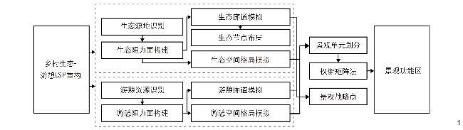
【目的】乡村旅游地的突出矛盾是人类旅游活动对生态环境的干扰,景观规划时需要权衡游憩功能与生态功能。探究乡村生态-游憩景观安全格局(landscape security pattern, LSP)重构路径,旨在促进乡村旅游与生态环境和谐、可持续发展,为乡村旅游地景观规划提供参考思路。【方法】以江苏省无锡市马山为例,综合运用InVEST、ArcSWAT、最小累积阻力(minimum cumulative resistance, MCR)多模型,分别模拟生态、游憩空间格局以及生态、游憩廊道,并划分景观单元;基于“权衡矩阵法”,比较各单元生态、游憩功能重要性,实现景观功能分区,识别权衡问题突出的区域及战略点,进而为各类景观功能区提出针对性的规划、建设及管控策略。【结果】将马山景观功能区划分为生态核心区、生态重要区、生态-游憩重点权衡区、生态-游憩次级权衡区、游憩核心区、游憩重要区、游憩协调区及弹性发展区8类,构建生态-游憩景观网络并识别出32处战略点。【结论】重构乡村生态-游憩LSP有利于区分不同类型景观功能区的建设侧重点与优先级,科学、精细化地管理、利用乡村景观资源,促进多功能景观的协调与增效。
刘颂 , 柳迪子 , 杜守帅 . 基于多模型和权衡矩阵法的乡村生态-游憩景观安全格局重构[J]. 风景园林, 2024 , 31(3) : 99 -105 . DOI: 10.3724/j.fjyl.202304170191
[Objective] The prominent contradiction faced by rural tourism destinations is the interference of human tourism activities with natural ecological environment, which has resulted in a series of ecological challenges such as habitat destruction, environmental pollution, and decline of ecosystem service efficiency. Therefore, equal importance should be attached to recreational function and ecological function in landscape planning. The theory of landscape security pattern (LSP) is an effective way to coordinate development and construction with ecological protection. Many scholars try to apply LSP in the research and practice of rural landscape. However, simply constructing LSP by superimposing multifunctional landscape spaces actually blurs the tradeoffs among various ecosystem services (ESs), and still leads to potential conflicts in the planning and layout of multifunctional spaces. In view of this, this research aims to explore a comprehensive LSP reconstruction path to coordinate the tradeoff between recreational function and ecological function in rural areas, so as to promote the harmonious and sustainable development of rural tourism and ecological environment. This research may provide a reference for landscape planning of rural tourism destinations.
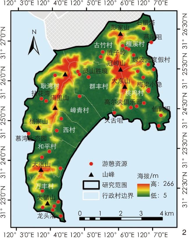
[Methods] This research takes Mashan, a typical rural tourist destination in Wuxi City, Jiangsu Province, as an example. Located in Taihu Lake National Tourism Resort, Mashan has experienced more than 30 years of tourism development. The research adopts multiple models of InVEST, ArcSWAT and MCR (minimum cumulative resistance) to simulate the spatial pattern, zoning and landscape corridor identification of ecological and recreational processes in the research area. The research divides the ecological security pattern into 5 levels and the recreational spatial pattern into 3 levels (including non-recreational areas), and divides twenty landscape units by superimposing ecological and recreational spatial patterns. Then, the research constructs a tradeoff matrix according to corresponding ecological and recreational importance levels of each landscape unit. Moreover, the research compares the importance of the two categories of functions to determine the construction focus and priority of each type of landscape unit, and then puts forward targeted planning, construction and control strategies for different types of landscape units. When the ecological and recreational functions of landscape units are both at a high level of importance, the tradeoff between the two categories of functions within the scope of such landscape units is significant, which requires the planning decision-makers to carefully consider the use of landscape resources. In addition, the collision points between important ecological corridors and recreational corridors are marked as landscape strategic points, which are the key to ensuring smooth ecological and recreational processes. During the design and construction of such strategic points, ecological connectivity should not be destroyed, and the integrity and continuity of the recreational process should be ensured.
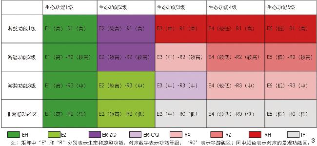
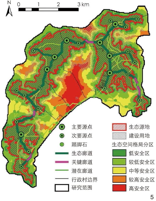
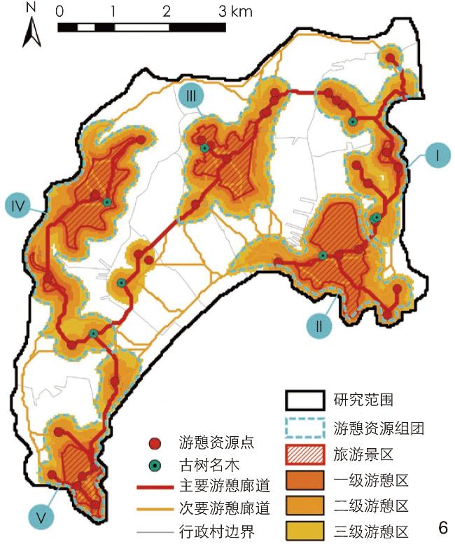
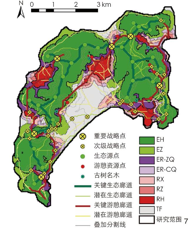
[Results] Before reconstructing the eco-recreational LSP, the research firstly constructs the ecological security pattern and the recreational landscape space pattern respectively in the research area. The ecological security pattern of Mashan is composed of 5 ecological sources, 24 ecological corridors and important ecological nodes. In terms of the recreational landscape space pattern, five areas of cultural landscape resources are identified, and rural tourism products are developed differentially according to the characteristics of cultural resources in different areas. At the same time, a recreational landscape network is constructed to connect the core recreation areas, so that the regional cultural landscape resources can form a joint force for integrated development. Most importantly, the landscape function areas involved in the eco-recreational LSP of Mashan can be divided into eight types: ecologically centered area (EH), ecologically important area (EZ), primary eco-recreational tradeoff area (ER-ZQ), secondary eco-recreational tradeoff area (ER-CQ), recreationally centered area (RH), recreationally important area (RZ), recreational coordinated area (RX) and elastically developed area (TF). According to the tradeoff relationship between ecological and recreational functions in different types of areas, corresponding planning, construction and control strategies are determined. In addition, according to the simulation results of ecological and recreational landscape corridors, six important landscape strategic points are identified.
[Conclusion] Upon reconstruction, the rural eco-recreational LSP is no longer a simple superposition for the development of multifunctional landscape and the fuzzy processing of multiple ecosystem service tradeoffs. Instead, it is more conducive to scientific and precise management and utilization of rural landscape resources by distinguishing the construction focus and priority of each landscape unit and identifying the areas with significant tradeoffs, thus promoting the coordinated development of multifunctional landscape and giving full play to the role of comprehensive ecosystem services. In addition, the reconstruction of the rural eco-recreational LSP is based on the integration of multiple models such as InVEST, ArcSWAT and MCR, which not only protects important landscape structures, but also emphasizes the protection of key landscape processes. Admittedly, there are also limitations in this research. Comparing the importance levels of ecological and recreational functions is of certain subjectivity, and employing the more quantitative method can improve the scientificity of landscape functional zoning.
| ESs | 评估方法 | 基本原理 |
|---|---|---|
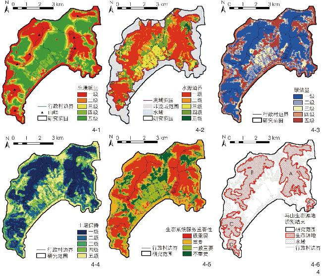
| 生物多样性 | Invest模型中的Habitat Quality(HQ)模块 | HQ模块计算结果反映区域支持物种生存、繁衍的效能与潜力,值越高,生物多样性水平越高。计算方法参见文献[24] |
| 水源涵养 | ArcSWAT模型,水量平衡法 | 通过ArcSWAT模拟水文响应单元(hydrological response unit, HRU)的降水量、蒸发量及地表径流量。利用水量平衡法计算水源涵养量,计算方法参见文献[14] |
| 碳存储 | Invest模型中的Carbon Storage and Sequestration(CS)模块 | CS模块计算方法可参考文献[25]。CS模块碳储量评价将同类景观内视作均质,忽视了植被健康状况的影响,本研究利用归一化植被指数(normalized difference vegetation index, NDVI)修正计算结果[23]: $ \qquad\qquad\qquad \qquad \qquad \qquad \qquad\qquad {C}_{i}=\dfrac{{N}_{i}}{{N}_{a}}\times C $。 (1) 式中:${C}_{i}$为栅格${i}$修正后的碳储量,${{N}_{i}}$为栅格${i}$的NDVI,${{N}_{a}}$为栅格${i}$所属景观类型$a$的NDVI平均值,${C}$为栅格${i}$的修正前的碳储量计算值 |
| 土壤保持 | 指标评价 | 选择土地覆被、植被覆盖、地形因素相关指标评价并赋值:土地覆被评价根据生态系统服务价值当量表[26]赋值;植被覆盖评价将NDVI重分类为10个等级并赋值;坡度评价参考相关研究[11, 20]分级赋值 |
表2 乡村景观生态、游憩过程阻力评价体系Tab. 2 Resistance evaluation system for ecological and recreational processes of rural landscape |
| 评价指标 | 分类标准 | 生态阻力评价 | 游憩阻力评价 | |||
|---|---|---|---|---|---|---|
| 赋值 | 权重 | 赋值 | 权重 | |||
| 注:表中“—”表示该处所对应的评价指标非本列生态或游憩阻力评价的指标。 | ||||||
| 景观覆盖类型 | 建设用地 | 10 | 0.5 | 1 | 0.2 | |
| 阔叶林地 | 0 | 4 | ||||
| 农田 | 6 | 8 | ||||
| 灌草丛 | 4 | 6 | ||||
| 裸地 | 2 | 10 | ||||
| 水域 | 0 | 10 | ||||
| 其他用地 | 8 | 2 | ||||
| 坡度 | 0~2° | 0 | 0.1 | 0 | 0.2 | |
| >2~6° | 1 | 1 | ||||
| >6~15° | 4 | 4 | ||||
| >15~25° | 7 | 7 | ||||
| >25° | 10 | 10 | ||||
| 高程 | 5~35 m | — | — | 1 | 0.2 | |
| >35~55 m | — | 4 | ||||
| >55~75 m | — | 7 | ||||
| >75 m | — | 10 | ||||
| 距建设用地距离 | 0~25 m | 10 | 0.1 | — | — | |
| >25~100 m | 7 | — | ||||
| >100~200 m | 4 | — | ||||
| >200 m | 1 | — | ||||
| 距主要道路距离 | 0~25 m | 10 | 0.1 | 1 | 0.2 | |
| >25~100 m | 7 | 4 | ||||
| >100~200 m | 4 | 7 | ||||
| >200 m | 1 | 10 | ||||
| 距太湖距离 | 0~100 m | — | — | 1 | 0.2 | |
| >100~200 m | — | 4 | ||||
| >200~300 m | — | 7 | ||||
| >300 m | — | 10 | ||||
| NDVI | 利用自然断点法 划分为10个等级 | 10个等级由高到低 依次赋值1~10 | 0.2 | — | — | |
图4 马山ESs重要性评价及生态源地识别结果Fig. 4 Evaluation of the importance of ESs and identification of ecological sources in Mashan |
图5 马山生态安全格局构建结果Fig. 5 Construction results of the ecological security pattern of Mashan |
图7 马山生态-游憩LSP构建结果Fig. 7 Construction results of the eco-recreational LSP of Mashan |
表3 马山生态-游憩LSP各功能分区的面积统计、分布特征及建设策略Tab. 3 Area statistics, distribution characteristics and construction strategies of each function area involved in the eco-recreational LSP of Mashan |
| 功能分区 | 面积/km2 | 分布特征 | 规划建设及管控策略 |
|---|---|---|---|
| EH | 18.62 | 海拔高、植被茂盛的山地,植被以林地为主,这里受干扰程度低、生境质量最优,是区域的生态源地 | 生态安全底线应严格禁止旅游开发、建设,避免对生态源地的干扰和破坏,保障ESs基本功能,补缀、修复生态孔隙,加强生态系统结构完整性、连通性,提升生境质量 |
| EZ | 3.71 | 环绕山底,这里多为村民的果园、苗圃,植被主要为经济林木、灌木,是保护生态源地的缓冲带 | 生态缓冲带保护源地,同时种植经济树种,利用农民果园、苗圃适当发展农业体验项目,提升生态系统经济价值 |
| RH | 2.17 | 主要景区(灵山胜境、拈花湾等)及游憩资源聚集的聚落附近 | 游憩资源丰富、文化价值高,是发展旅游产品的核心驱动力,应首先考虑修缮与保护游憩资源,保护原真性;同时,可参考图6游憩资源组团,差异化开发特色旅游产品与活动 |
| RZ | 0.45 | 分布在主要景区及游憩资源高度聚集的聚落附近(分布在RH周围),地势平坦,交通便利 | 游憩核心区的拓展应结合核心区主题发展相关文旅产业、完善配套设施,村庄可借力发展民宿、农家乐等特色产业,提高游憩核心区的服务能力并扩大服务范围 |
| RX | 1.69 | 分布在主要景区及游憩资源聚集区外围的平坦区域,在RZ周围 | 游憩核心区、重要区与外界联系的过渡,应从塑造景观风貌、营造文化氛围的角度与核心区、重要区相协调,起到宣传、推广与形象展示的作用 |
| ER-ZQ | 3.03 | 分布在主要景区及聚落靠山体一侧的交错带,这里是生态源地的缓冲带,游憩资源也很丰富、条件适宜,但生态、游憩功能权衡问题突出 | 生态、游憩功能权衡问题突出,建议重点协调二者关系,游憩资源以保护、修缮为主,不进行规模性、拓展性开发,不可破坏生态缓冲带,可通过种植经济林木保障生态价值 |
| ER-CQ | 0.80 | 分布在游憩区域与农田、园地交错的平缓地带,这里生态、游憩功能重要性均中等,权衡问题不显著 | 生态、游憩功能重要性均为中等,权衡问题不显著,可根据实际需求确定建设重点,景观用途满足生态、游憩功能基本协调即可 |
| TF | 3.84 | 海拔低、地势平缓,距山体较远,景观类型主要为农田 | 该区域以农田为主,应重点保障农业生产质量,建议结合田园景观规划理念提升其游憩、观赏价值 |
文中图表均由作者绘制。
| [1] |
刘颂, 刘蕾. 基于生态安全的区域生态空间弹性规划研究: 以山东省滕州市为例[J]. 中国园林, 2020, 36 (2): 11-16.
LIU S, LIU L. Flexible Planning of Regional Ecological Space for Ecological Security: A Case Study of Tengzhou City, Shandong Province[J]. Chinese Landscape Architecture, 2020, 36 (2): 11-16.
|
| [2] |
XU X B, YANG G S, TAN Y. Identifying Ecological Red Lines in China’s Yangtze River Economic Belt: A Regional Approach[J]. Ecological Indicators, 2019, 96: 635-646.
|
| [3] |
YI D, GUO X, HAN Y, et al. Coupling Ecological Security Pattern Establishment and Construction Land Expansion Simulation for Urban Growth Boundary Delineation: Framework and Application[J]. Land, 2022, 11 (3): 359.
|
| [4] |
YU K J. Security Patterns and Surface Model in Landscape Ecological Planning[J]. Landscape and Urban Planning, 1996, 36 (1): 1-17.
|
| [5] |
俞孔坚, 李迪华, 韩西丽, 等. 新农村建设规划与城市扩张的景观安全格局途径: 以马岗村为例[J]. 城市规划学刊, 2006 (5): 38-45.
YU K J, LI D H, HAN X L, et al. Rescuing a Village: The Approach of Landscape Security Patterns: With the Case of Magang, Shunde, Guangdong Province[J]. Urban Planning Forum, 2006 (5): 38-45.
|
| [6] |
谢志林, 陈升忠. 基于生态安全格局的新农村规划探索: 以广东省饶平县新丰镇洞泉村为例[J]. 安徽农业科学, 2009, 37 (12): 5741-5743.
XIE Z L, CHEN S Z. Discussion on New Rural Planning Based on Ecological Safety Pattern[J]. Journal of Anhui Agricultural Sciences, 2009, 37 (12): 5741-5743.
|
| [7] |
瞿奇, 王云才. 基于生态质量评价的村域生态安全格局规划研究: 以吉林省长白县孤山子村为例[J]. 中国城市林业, 2013, 11 (5): 32-35.
QU Q, WANG Y C. Village Ecological Security Pattern Planning Based on Ecological Quality Evaluation: A Case Study of Gushanzi Village, Changbai County, Jilin Province[J]. Journal of Chinese Urban Forestry, 2013, 11 (5): 32-35.
|
| [8] |
FU B, WANG S, SU C, et al. Linking Ecosystem Processes and Ecosystem Services[J]. Current Opinion in Environmental Sustainability, 2013, 5 (1): 4-10.
|
| [9] |
林小如, 贾宇轩, 黄友谊, 等. 山区流域地貌单元水系生态安全分类治理: 基于流域生态学视角[J]. 南方建筑, 2023 (9): 32-35.
LIN X R, JIA Y X, HUANG Y Y, et al. The Classification and Governance of Water System Ecological Security in Mountainous Watersheds: A Case Study from the Perspective Watershed Ecology[J]. South Architecture, 2023 (9): 32-35.
|
| [10] |
黄雪飞, 吴次芳, 游和远, 等. 基于MCR模型的水网平原区乡村景观生态廊道构建[J]. 农业工程学报, 2019, 35 (10): 243-251.
HUANG X F, WU C F, YOU H Y, et al. Construction of Rural Landscape Ecological Corridor in Water Network Plain Area Based on MCR Model[J]. Transactions of the Chinese Society of Agricultural Engineering, 2019, 35 (10): 243-251.
|
| [11] |
王嘉, 高静, 袁睦茜, 等. 生物保护视角下乡村景观生态安全格局构建: 以山西省临汾市汾西县永安镇后加楼村为例[J]. 生态科学, 2021, 40 (1): 155-161.
WANG J, GAO J, YUAN M Q, et al. Construction of Rural Landscape Ecological Security Pattern from the Perspective of Biological Protection: A Case Study of Houjialou Village, Yong’an Town, Fenxi County, Linfen City, Shanxi Province[J]. Ecological Science, 2021, 40 (1): 155-161.
|
| [12] |
聂文彬, 史琰, 杨凡, 等. 基于综合生态安全格局的山地景观韧性体系构建研究: 以浙江莫干山为例[J]. 中国园林, 2022, 38 (2): 127-132.
NIE W B, SHI Y, YANG F, et al. Study on the Construction of Mountain Landscape Resilience System Based on Comprehensive Ecological Security Pattern: A Case Study of Mogan Mountain in Zhejiang Province[J]. Chinese Landscape Architecture, 2022, 38 (2): 127-132.
|
| [13] |
胡其玉, 陈松林. 基于生态系统服务供需的厦漳泉地区生态网络空间优化[J]. 自然资源学报, 2021, 36 (2): 342-355.
HU Q Y, CHEN S L. Optimizing the Ecological Networks Based on the Supply and Demand of Ecosystem Services in Xiamen-Zhangzhou-Quanzhou Region[J]. Journal of Natural Resources, 2021, 36 (2): 342-355.
|
| [14] |
高梦雯, 胡业翠, 李向, 等. 基于生态系统服务重要性和环境敏感性的喀斯特山区生态安全格局构建: 以广西河池为例[J]. 生态学报, 2021, 41 (7): 2596-2608.
GAO M W, HU Y C, LI X, et al. Construction of Ecological Security Pattern Based on the Importance of Ecosystem Services and Environmental Sensitivity in Karst Mountainous Areas: A Case Study in Hechi, Guangxi[J]. Acta Ecologica Sinica, 2021, 41 (7): 2596-2608.
|
| [15] |
王浩, 马星, 杜勇. 基于生态系统服务重要性和生态敏感性的广东省生态安全格局构建[J]. 生态学报, 2021, 41 (5): 1705-1715.
WANG H, MA X, DU Y. Constructing Ecological Security Patterns Based on Ecological Service Importance and Ecological Sensitivity in Guangdong Province[J]. Acta Ecologica Sinica, 2021, 41 (5): 1705-1715.
|
| [16] |
官紫玲, 陈顺和. 乡土文化景观安全格局及遗产廊道构建研究: 以福建永泰为例[J]. 中国园林, 2020, 36 (2): 96-100.
GUAN Z L, CHEN S H. Study on the Safety Pattern of Local Cultural Landscape and the Construction of Heritage Corridor: Taking in Yongtai, Fujian as an Example[J]. Chinese Landscape Architecture, 2020, 36 (2): 96-100.
|
| [17] |
赵耀, 龙彬, 张菁. 区域尺度下的传统村落景观安全格局构建与保护策略研究: 以云南腾冲为例[J]. 中国园林, 2023, 39 (9): 67-73.
ZHAO Y, LONG B, ZHANG J. Study on the Construction of Traditional Village Landscape Security Pattern and Protection Strategy at the Regional Scale: A Case Study of Tengchong City in Yunnan Province[J]. Chinese Landscape Architecture, 2023, 39 (9): 67-73.
|
| [18] |
FU B, WU X, WANG Z, et al. Coupling Human and Natural Systems for Sustainability: Experience from China’s Loess Plateau[J]. Earth System Dynamics, 2022, 13 (2): 795-808.
|
| [19] |
吴隽宇, 朱榴奕. 生态系统环境-文化服务耦合视角下的珠江河口区生态功能分区[J]. 风景园林, 2023, 30 (1): 85-93.
WU J Y, ZHU L Y. Ecological Function Regionalization in Pearl River Estuary Area from the Perspective of the Coupling of Environmental and Cultural Ecosystem Services[J]. Landscape Architecture, 2023, 30 (1): 85-93.
|
| [20] |
熊星, 唐晓岚, 刘澜, 等. 基于“源-汇”理论的传统乡村景观安全格局构建[J]. 南京林业大学学报(自然科学版), 2019, 43 (6): 143-151.
XIONG X, TANG X L, LIU L, et al. Traditional Rural Landscape Security Pattern Construction Based on “Source-Sink” Theory[J]. Journal of Nanjing Forestry University (Natural Sciences Edition), 2019, 43 (6): 143-151.
|
| [21] |
徐惠红. 无锡市马山志[M]. 南京: 南京出版社, 2015.
XU H H. The Chronicle of Mashan, Wuxi[M]. Nanjing: Nanjing Press, 2015.
|
| [22] |
柳迪子, 杜守帅, 王晨旭. 旅游型乡村景观格局变化及生态系统服务价值响应: 以江苏省无锡市太湖国家旅游度假区为例[J]. 水土保持通报, 2021, 41 (5): 264-275.
LIU D Z, DU S S, WANG C X. Landscape Pattern Change and Its Response to Ecosystem Services Value in a Rural Tourism Area: A Case Study at Taihu National Tourism Resort in Wuxi City of Jiangsu Province[J]. Bulletin of Soil and Water Conservation, 2021, 41 (5): 264-275.
|
| [23] |
彭建, 郭小楠, 胡熠娜, 等. 基于地质灾害敏感性的山地生态安全格局构建: 以云南省玉溪市为例[J]. 应用生态学报, 2017, 28 (2): 627-635.
PENG J, GUO X N, HU Y N, et al. Constructing Ecological Security Patterns in Mountain Areas Based on Geological Disaster Sensitivity: A Case Study in Yuxi City, Yunnan Province, China[J]. Chinese Journal of Applied Ecology, 2017, 28 (2): 627-635.
|
| [24] |
钟莉娜, 王军. 基于InVEST模型评估土地整治对生境质量的影响[J]. 农业工程学报, 2017, 33 (1): 250-255.
ZHONG L N, WANG J. Evaluation on Effect of Land Consolidation on Habitat Quality Based on InVEST Model[J]. Transactions of the Chinese Society of Agricultural Engineering, 2017, 33 (1): 250-255.
|
| [25] |
吴隽宇, 张一蕾, 江伟康. 粤港澳大湾区生态系统碳储量时空演变[J]. 风景园林, 2020, 27 (10): 57-63.
WU J Y, ZHANG Y L, JIANG W K. Spatio-Temporal Evolution of Ecosystem Carbon Storage in Guangdong −Hong Kong − Macao Greater Bay Area[J]. Landscape Architecture, 2020, 27 (10): 57-63.
|
| [26] |
谢高地, 张彩霞, 张雷明, 等. 基于单位面积价值当量因子的生态系统服务价值化方法改进[J]. 自然资源学报, 2015, 30 (8): 1243-1254.
XIE G D, ZHANG C X, ZHANG L M, et al. Improvement of the Evaluation Method for Ecosystem Service Value Based on Per Unit Area[J]. Journal of Natural Resources, 2015, 30 (8): 1243-1254.
|
| [27] |
樊柏青, 成玉宁. 乡村生态景观识别与生境网络优化: 以南京市江宁区为例[J]. 风景园林, 2023, 30 (4): 27-33.
FAN B Q, CHENG Y N. Rural Ecological Landscape Identification and Habitat Network Optimization: A Case Study of Jiangning District, Nanjing[J]. Landscape Architecture, 2023, 30 (4): 27-33.
|
| [28] |
兰亦阳, 来昕, 郑曦. 基于生态源地与生态廊道优先级评估的生态安全格局构建与优化: 以石家庄都市区为例[J]. 风景园林, 2023, 30 (2): 131-138.
LAN Y Y, LAI X, ZHENG X. Construction and Optimization of Ecological Security Pattern Based on Priority Assessment of Ecological Source and Ecological Corridor: A Case Study of Shijiazhuang Metropolitan Area[J]. Landscape Architecture, 2023, 30 (2): 131-138.
|
| [29] |
滕耀宝. 基于最小阻力模型的潇贺古道遗产廊道网络构建研究[J]. 规划师, 2020, 36 (8): 66-70.
TENG Y B. Xiaohe Ancient Road Heritage Corridor Construction Based on Minimum Cumulative Resistance Model[J]. Planners, 2020, 36 (8): 66-70.
|
| [30] |
陈琳, 胡希军, 韦宝婧, 等. 湖南沅水流域传统聚落空间分布与遗产廊道适宜性分析[J]. 现代城市研究, 2022 (7): 112-119.
CHEN L, HU X J, WEI B J, et al. Study on Spatial Distribution of Traditional Settlements and Suitability Analysis of Heritage Corridors in Yuanshui River Basin, Hunan Province[J]. Modern Urban Research, 2022 (7): 112-119.
|
/
| 〈 |
|
〉 |