
基于可解释机器学习与多目标优化算法的山区绿色基础设施格局优化——以北京市浅山区为例
|
田双志/男/北京林业大学园林学院硕士研究生/研究方向为风景园林规划与设计 |
|
于铭/女/北京林业大学园林学院在读硕士研究生/研究方向为风景园林规划与设计 |
|
李汶晓/女/北京林业大学园林学院本科生/研究方向为风景园林规划与设计 |
|
陈泓宇/男/博士/南京农业大学园艺学院讲师/研究方向为风景园林规划与设计 |
|
林辰松/男/博士/北京林业大学园林学院副教授/城乡生态环境北京实验室研究员/研究方向为风景园林规划与设计、景观水文 |
Copy editor: 王一兰 李清清
收稿日期: 2025-08-10
修回日期: 2025-10-30
网络出版日期: 2025-12-26
基金资助
国家自然科学基金“北京浅山区绿色空间低影响开发机制及多目标优化模型研究”(52208042)
北京市共建项目(2015BLUREE01)
上海市城市设计与城市科学重点实验室开放课题(2024CSLin_LOUD)
版权
Optimization of Green Infrastructure Patterns in Mountainous Areas Based on Interpretable Machine Learning and Multi-objective Optimization Algorithm: A Case Study of Shallow Mountainous Areas in Beijing
|
TIAN Shuangzhi is a Master graduate of the School of Landscape Architecture, Beijing Forestry University. His research focuses on landscape planning and design |
|
YU Ming is a master student in the School of Landscape Architecture, Beijing Forestry University. Her research focuses on landscape planning and design |
|
LI Wenxiao is an undergraduate student in the School of Landscape Architecture, Beijing Forestry University. Her research focuses on landscape planning and design |
|
CHEN Hongyu, Ph.D., is a lecturer in the College of Horticulture, Nanjing Agricultural University. His research focuses on landscape planning and design |
|
LIN Chensong, Ph.D., is an associate professor in the School of Landscape Architecture, Beijing Forestry University, and a research fellow in Beijing Laboratory of Urban and Rural Ecological Environment. His research focuses on landscape planning and design, and landscape hydrology |
Received date: 2025-08-10
Revised date: 2025-10-30
Online published: 2025-12-26
Copyright
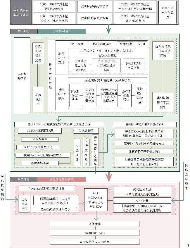
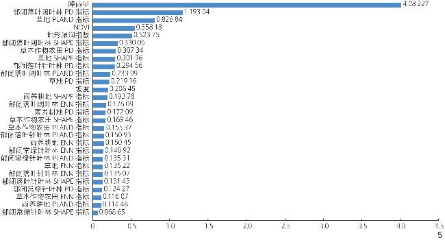
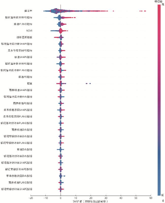
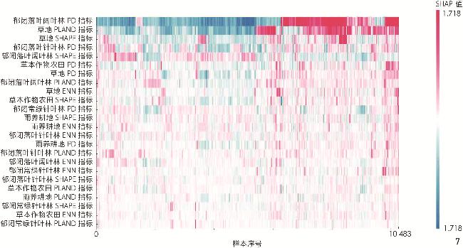
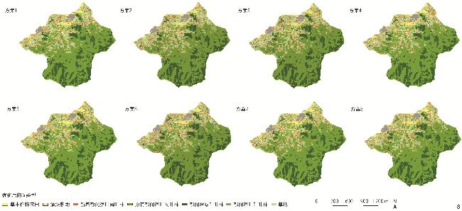
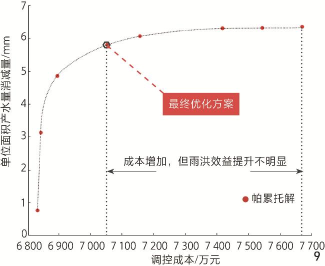
【目的】气候变化的加剧显著提升了浅山地区的洪涝风险。明晰绿色基础设施(green infrastructure, GI)空间格局特征对山地雨洪的作用机制,并优化其空间格局,可加强浅山区的洪涝防治能力,减轻极端降雨的消极影响。【方法】1)通过SWAT软件与XGBoost机器学习模型,构建基于GI空间格局特征的高精度山地雨洪产流预测代理模型;2)使用基于SHAP的机器学习解释工具对该模型进行解释,定量揭示各类GI空间格局特征对山地雨洪产流的影响机制;3)基于影响机制,使用NSGA-Ⅱ多目标优化算法对浅山区典型区域内的关键GI进行格局优化,以检验GI格局优化的雨洪消减效果。【结果】训练得出的山地雨洪产流预测模型拥有优秀的预测模拟性能。对该模型进行解释,发现郁闭落叶阔叶林的斑块密度以及草地的斑块面积比例是与山地雨洪产流正相关的关键格局特征;对二者进行优化的最优格局可在百年一遇的历史极端降雨情景下降低13.5%的洪涝风险。【结论】本研究通过应用可解释机器学习技术,成功揭示了不同GI空间格局特征对山地雨洪产流的影响,并对关键格局特征的作用机制进行探讨,提出林地斑块联通、草地斑块缩小以促进最优GI格局的策略,减小强降雨下山地区域的洪涝风险。研究成果可为类似地区的山地绿色空间规划提供有效技术支持和实践指导。
田双志 , 于铭 , 李汶晓 , 陈泓宇 , 林辰松 . 基于可解释机器学习与多目标优化算法的山区绿色基础设施格局优化——以北京市浅山区为例[J]. 风景园林, 2025 , 32(12) : 56 -66 . DOI: 10.3724/j.fjyl.LA20250484
[Objective] The intensification of climate change has led to a significant escalation in flood risk within shallow mountainous areas, posing a severe threat to human life, health, and ecological security. These transitional areas, often situated at the interface between mountainous terrain and urbanized plains, are uniquely vulnerable to the hydrological impacts of extreme precipitation. Existing research has established that green infrastructure (GI), through its influence on fundamental hydrological processes such as the rainfall – runoff and runoff – sediment relationships, can play a pivotal role in stormwater management. However, the current body of literature predominantly focuses on two main scales: the effectiveness of individual GI elements at the localized plot level and the impact of the broader green space matrix at the large basin scale. Consequently, a critical knowledge gap persists concerning the influence of the spatial configuration of GI patches — such as their shape, size, and degree of fragmentation — on hydrological responses at the finer, sub-basin scale, which is the most relevant scale for understanding flood generation. Clarifying the mechanisms through which GI spatial patterns affect mountainous stormwater runoff and subsequently optimizing these patterns are crucial steps toward enhancing the flood prevention and control capabilities of shallow mountainous areas. This research aims to bridge the knowledge gap by elucidating these mechanisms and developing an optimization framework to mitigate the adverse effects of extreme rainfall in the sensitive shallow mountainous areas.
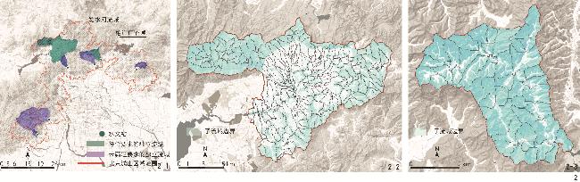
[Methods] This research adopts a two-stage research framework, comprising the two stages of mechanism exploration and pattern optimization. In the stage of exploration of hydrological mechanisms, two sample basins are selected within the shallow mountainous area of Beijing and, based on historical meteorological data and land cover data, the SWAT (soil and water assessment tool) model is used to simulate runoff generation in mountainous sub-basins with high spatiotemporal resolution. Meanwhile, machine learning methods, specifically an XGBoost-based model, are applied to the sample data to construct a high-accuracy predictive model for stormwater runoff generation, with a focus on GI spatial pattern characteristics as predictor variables. To interpret the machine learning results, the SHAP (SHapley Additive exPlanations) framework is employed to quantitatively elucidate the impact mechanisms of various GI spatial pattern metrics on mountainous stormwater runoff. In the pattern optimization stage, key GI spatial metrics are identified as optimization variables based on their hydrological influence. Under a dual-objective framework emphasizing both cost-effectiveness and flood mitigation efficacy, the NSGA-Ⅱ (nondominated sorting genetic algorithm Ⅱ) is used to optimize GI configuration for a representative shallow mountainous area. The effectiveness of these optimizations in reducing flood risks is validated through extreme historical rainfall scenarios.
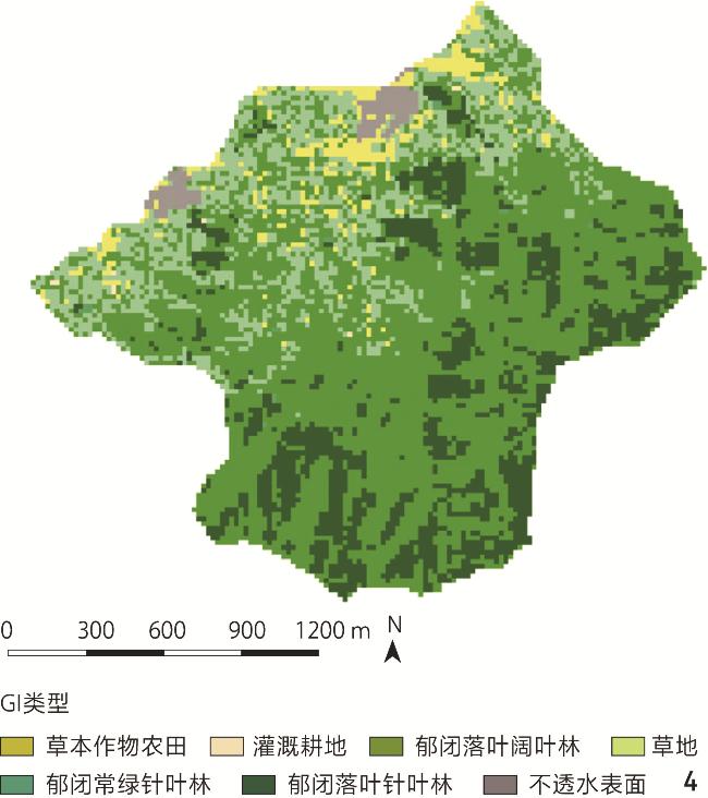
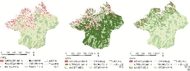
[Results] The resulting predictive model for mountainous runoff generation demonstrates excellent simulation and forecasting capabilities, especially in modeling the influence of GI spatial pattern changes on runoff processes in complex mountainous terrains. The interpretive analysis using SHAP on the trained model provides crucial insights into the underlying mechanisms. Among the numerous GI landscape metrics evaluated, two features emerge as the most critical drivers positively correlated with increased mountainous stormwater runoff: the patch density (PD) of closed-canopy deciduous broad-leaved forests and the percent of landscape (PLAND) occupied by grasslands. The analysis reveals that an increase in either of the aforesaid two metrics consistently contributes to higher predicted runoff volumes. In contrast, the spatial pattern characteristics of other vegetation types, such as closed-canopy evergreen coniferous forests and closed-canopy deciduous coniferous forests, are found with a comparatively weak and less significant influence on the hydrological response. During the multi-objective pattern optimization process, using the two most influential metrics (PD and PLAND) as adjustable variables for a typical area, the optimized spatial pattern is able to reduce flood risk by 13.5% under the scenario of once-in-a-century extreme rainfall.
[Conclusion] The XGBoost machine learning model displays outstanding applicability for flood risk assessment and hydrological scenario simulation in shallow mountainous areas. An in-depth analysis of the GI spatial metrics identified by SHAP interpretation suggests that the fragmentation resulting from increased PD of closed-canopy deciduous broad-leaved forests, together with the impact of grassland PLAND on the runoff coefficient, are the core driving factors of stormwater runoff generation in these mountainous contexts. Additionally, the shape and configuration of grassland patches may further promote stormwater runoff. Accordingly, in the process of optimizing GI spatial arrangements in shallow mountainous areas, enhancing the connectivity of closed-canopy deciduous broad-leaved forest while reducing the size of large grassland patches is found conducive to forming optimal GI layouts that reduce flood risk under extreme precipitation. Through the application of interpretable machine learning techniques, this research reveals the underlying mechanisms by which different GI spatial pattern metrics influence mountain runoff generation and, based on these findings, effectively reduces regional flood risk during extreme rainfall events. The methodological approach and practical guidance provided by this research offer robust technical support for flood-mitigating green space planning in similar shallow mountain terrains and contribute valuable experience for regional adaptation to intensified climate-driven stormwater challenges.
表1 基础数据类别及来源Tab. 1 Basic data categories and sources |
| 基础数据类别 | 数据时空精度 | 数据来源 |
|---|---|---|
| 注:因本研究数据收集工作在2023年完成,故数据获取时间截至2023年。 | ||
| 浅山区水文站逐日历史流量数据 | 日尺度 | 北京市水文总站(北京市水务局水质水生态监测中心) |
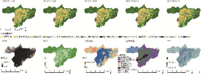
| 2003—2023年浅山区精细化土地覆盖数据(China Land Cover Dataset, CLCD) | 5年尺度,空间分辨率30 m | 可持续发展大数据国际研究中心 |
| 2003—2023年浅山区逐月NDVI数据 | 月尺度,空间分辨率250 m | 国家青藏高原科学数据中心 |
| 浅山区DEM数据 | 空间分辨率30 m | 欧洲航天局(European Space Agency)哥白尼数字高程模型(Copernicus DEM, COP-DEM) |
| 2003—2023年浅山区逐日气象数据 | 日尺度 | 国家气象科学数据中心 |
| 浅山区土壤地质数据 | 世界土壤数据库(Harmonized World Soil Database, HWSD) | |
| 北京市河网水系数据 | 开放街道地图(OpenStreetMap, OSM) | |
表2 选用的GI景观格局指数及其释义Tab. 2 Selected GI landscape pattern indices and their interpretation |
| 类型 | 名称 | 尺度 | 生态学意义 |
|---|---|---|---|
| 面积指标 | 斑块面积比例(percent of landscape, PLAND) | 类型/斑块 | 各地类占总面积的比例,面积最大的为主要景观 |
| 密度大小指标 | 斑块密度(patch density, PD) | 类型/斑块 | 某种斑块在景观中的密度,可反映出景观整体的异质性与破碎度,以及某一类型的破碎化程度 |
| 聚集度指标 | 欧氏近邻距离(euclidean nearest neighbor distance, ENN) | 景观/类型/斑块 | 某类型斑块最短边到最近同类型相邻斑块的距离,以直观反映斑块聚集程度 |
| 形状指标 | 形状指数(mean shape index, SHAPE-MN) | 类型/斑块 | 表示景观或斑块形状与相同面积的正方形之间的偏离程度,值越大,斑块形状越复杂 |
1、方法创新:结合可解释机器学习(SWAT+XGBoost+SHAP)和多目标优化算法(NSGA-Ⅱ),解析了浅山区关键绿色基础设施格局特征对洪涝风险的作用机制,实现了空间优化决策的科学可视化。
2、机理突破:定量揭示了林地破碎化(高斑块密度)与大面积草地是加剧山地雨洪产流的核心驱动因子,深化了对景观格局水文效应的科学理解。
3、实践价值:建立了高精度山地雨洪产流预测代理模型,提出的多目标优化方案可在百年一遇极端降雨情景下降低13.5%的洪涝风险,具有强现实与推广意义。
| [1] |
Intergovernmental Panel on Climate Change (IPCC). Climate Change 2021: The Physical Science Basis: Working Group I Contribution to the Sixth Assessment Report of the Intergovernmental Panel on Climate Change[M/OL]. New York: Cambridge University Press, 2023[2025-07-23]. https://www.cambridge.org/core/product/identifier/9781009157896/type/book.
|
| [2] |
PEI Y J, LIU J H, WANG J, et al Effects of Urbanization on Extreme Precipitation Based on Weather Research and Forecasting Model: A Case Study of Heavy Rainfall in Beijing[J]. Journal of Hydrology: Regional Studies, 2024, 56: 102078.
|
| [3] |
张芳华, 杨舒楠, 胡艺, 等 “23·7”华北特大暴雨过程的水汽特征[J]. 气象, 2023, 49 12 1421.-1434.
ZHANG F H, YANG S N, HU Y, et al Water Vapor Characteristics of the July 2023 Severe Torrential Rain in North China[J]. Meteorological Monthly, 2023, 49 12 1421.-1434.
|
| [4] |
杨晓亮, 杨敏, 金晓青, 等.“23·7”河北罕见特大暴雨过程降水演变与中尺度特征分析[J]. 暴雨灾害, 2024, 43(1): 1-12.
YANG X L, YANG M, JIN X Q, et al. Analysis of Precipitation Evolution and Mesoscale Characteristics for A Severe Torrential Rain Event in Hebei from 29 July to 2 August 2023[J/OL]. Torrential Rain and Disasters, 2024, 43(1): 1-12.
|
| [5] |
北京日报. 北京市防汛救灾新闻发布会举行本次洪涝灾害造成30余万人受灾[EB/OL].[2025-08-10]. https://swj.beijing.gov.cn/swdt/swyw/202508/t20250801_4164010.html.
Beijing Daily, Beijing Flood Control and Disaster Relief News Conference Held This Flooding Caused more than 300,000 People Affected[EB/OL]. [2025-08-10]. https://swj.beijing.gov.cn/swdt/swyw/202508/t20250801_4164010.html.
|
| [6] |
北京日报.北京通报此次极端强降雨造成的伤亡情况[EB/OL].(2025-07-31)[2025-08-10]. https://news.qq.com/rain/a/20250731A0743700.
Beijing Daily. Beijing Informs of Casualties Caused by This Extreme Rainfall[EB/OL]. (2025-07-31)[2025-08-10]. https://news.qq.com/rain/a/20250731A0743700.
|
| [7] |
华杨 全球三大绿色基础设施体系及其对中国的借鉴[J]. 生态城市与绿色建筑, 2018 (4): 26.-29.
HUA Y Three Global Green Infrastructure Systems and Its Reference to China[J]. Eco-City and Green Building, 2018 (4): 26.-29.
|
| [8] |
LE X H, KIM Y, VAN BINH D, et al Improving Rainfall-Runoff Modeling in the Mekong River Basin Using Bias-Corrected Satellite Precipitation Products by Convolutional Neural Networks[J]. Journal of Hydrology, 2024, 630: 130762.
|
| [9] |
SOHN W, BAE J, NEWMAN G Green Infrastructure for Coastal Flood Protection: The Longitudinal Impacts of Green Infrastructure Patterns on Flood Damage[J]. Applied Geography, 2021, 135: 102565.
|
| [10] |
WANG Z H, LI Z H, WANG Y F, et al Building Green Infrastructure for Mitigating Urban Flood Risk in Beijing, China[J]. Urban Forestry & Urban Greening, 2024, 93: 128218.
|
| [11] |
BATTEMARCO B P, TARDIN-COELHO R, VERÓL A P, et al Water Dynamics and Blue-Green Infrastructure (BGI): Towards Risk Management and Strategic Spatial Planning Guidelines[J]. Journal of Cleaner Production, 2022, 333: 129993.
|
| [12] |
HOU J, FU B J Research on the Relationship Between Vegetation and Soil Resource Patterns on Lands Abandoned at Different Times[J]. Catena, 2014, 115: 1.-10.
|
| [13] |
PENG Y, WANG Q H, WANG H T, et al Does Landscape Pattern Influence the Intensity of Drought and Flood?[J]. Ecological Indicators, 2019, 103: 173.-181.
|
| [14] |
VAN NIEUWENHUYSE B H J, ANTOINE M, WYSEURE G, et al Pattern-Process Relationships in Surface Hydrology: Hydrological Connectivity Expressed in Landscape Metrics[J]. Hydrological Processes, 2011, 25 24 3760.-3773.
|
| [15] |
ZELLNER M, MASSEY D, MINOR E, et al Exploring the Effects of Green Infrastructure Placement on Neighborhood-Level Flooding via Spatially Explicit Simulations[J]. Computers, Environment and Urban Systems, 2016, 59: 116.-128.
|
| [16] |
林辰松.半湿润地区集雨型绿地设计研究[D].北京: 北京林业大学, 2017.
LIN C S. The Research on Rainwater Harvesting Green Space Design in Semi-humid Region[D]. Beijing: Beijing Forestry University, 2017.
|
| [17] |
LI J, ZHOU Z X Coupled Analysis on Landscape Pattern and Hydrological Processes in Yanhe Watershed of China[J]. Science of the Total Environment, 2015, 505: 927.-938.
|
| [18] |
KIM M, SONG K, CHON J Key Coastal Landscape Patterns for Reducing Flood Vulnerability[J]. Science of the Total Environment, 2021, 759: 143454.
|
| [19] |
WEBBER M K, SAMARAS C A Review of Decision Making Under Deep Uncertainty Applications Using Green Infrastructure for Flood Management[J]. Earth’s Future, 2022, 10 (7): e2021EF002322.
|
| [20] |
LEMPERT R J, POPPER S W, BANKES S C. Shaping the Next One Hundred Years: New Methods for Quantitative, Long-Term Policy Analysis[R/OL]. (2003-01-01)[2025-07-28]. https://www.rand.org/pubs/monograph_reports/MR1626.html.
|
| [21] |
MARCHAU V A W J, WALKER W E, BLOEMEN P J T M, et al. Decision Making under Deep Uncertainty: From Theory to Practice[M/OL]. Cham: Springer International Publishing, 2019[2025-07-28]. http://link.springer.com/10.1007/978-3-030-05252-2.
|
| [22] |
林辰松, 董宇翔, 陈泓宇, 等 基于NSGA-Ⅱ算法的集雨型绿地低影响开发设施规模优化计算方法及应用: 以南阳院士小镇为例[J]. 风景园林, 2020, 27 12 92.-97.
LIN C S, DONG Y X, CHEN H Y, et al Optimal Calculation Method of Size of LID Facilities for Rainwater Harvesting Green Space Based on NSGA-Ⅱ Algorithm and Application: A Case Study of Nanyang Academician Town[J]. Landscape Architecture, 2020, 27 12 92.-97.
|
| [23] |
BARREDO ARRIETA A, DÍAZ-RODRÍGUEZ N, DEL SER J, et al Explainable Artificial Intelligence (XAI): : Concepts, Taxonomies, Opportunities and Challenges Toward Responsible AI[J]. Information Fusion, 2020, 58 C 82.-115.
|
| [24] |
NGUYEN D H, HIEN LE X, HEO J Y, et al Development of an Extreme Gradient Boosting Model Integrated with Evolutionary Algorithms for Hourly Water Level Prediction[J]. IEEE Access, 2021, 9: 125853.-125867.
|
| [25] |
PRADHAN B, LEE S, DIKSHIT A, et al Spatial Flood Susceptibility Mapping Using an Explainable Artificial Intelligence (XAI) Model[J]. Geoscience Frontiers, 2023, 14 (6): 101625.
|
| [26] |
TEHRANY M S, PRADHAN B, MANSOR S, et al Flood Susceptibility Assessment Using GIS-Based Support Vector Machine Model with Different Kernel Types[J]. Catena, 2015, 125: 91.-101.
|
| [27] |
WANG M, LI Y X, YUAN H J, et al An XGBoost-SHAP Approach to Quantifying Morphological Impact on Urban Flooding Susceptibility[J]. Ecological Indicators, 2023, 156: 111137.
|
| [28] |
余祺, 时晨燚, 庄娜娜, 等 子流域景观格局对丹江口水库营养状态的影响分析[J]. 环境科学研究, 2024, 37 (8): 1714.-1724.
YU Q, SHI C Y, ZHUANG N N, et al Analysis of Impact of Sub-watersheds Landscape Patterns on Trophic State of Danjiangkou Reservoir[J]. Research of Environmental Sciences, 2024, 37 (8): 1714.-1724.
|
| [29] |
CHEN H Y, DONG Y X, LI H, et al Optimized Green Infrastructure Planning at the City Scale Based on an Interpretable Machine Learning Model and Multi-objective Optimization Algorithm: A Case Study of Central Beijing, China[J]. Landscape and Urban Planning, 2024, 252: 105191.
|
| [30] |
ZHU Y F, XU C Q, LIU Z J, et al Spatial Layout Optimization of Green Infrastructure Based on Life-Cycle Multi-objective Optimization Algorithm and SWMM Model[J]. Resources, Conservation and Recycling, 2023, 191: 106906.
|
| [31] |
WANG J, LIU J H, YANG Z X, et al Green Infrastructure Optimization Considering Spatial Functional Zoning in Urban Stormwater Management[J]. Journal of Environmental Management, 2023, 344: 118407.
|
| [32] |
ZHANG X, LIU W, FENG Q, et al Multi-objective Optimization of the Spatial Layout of Green Infrastructures with Cost-Effectiveness Analysis Under Climate Change Scenarios[J]. Science of the Total Environment, 2024, 948: 174851.
|
| [33] |
ZHOU H, GAO C, LUAN Q H, et al Multi-objective Optimization of Distributed Green Infrastructure for Effective Stormwater Management in Space-Constrained Highly Urbanized Areas[J]. Journal of Hydrology, 2024, 644: 132065.
|
| [34] |
张文晴, 侯精明, 王俊珲, 等 耦合NSGA-Ⅱ算法与高精度水动力模型的LID设施优化设计方法研究[J]. 水资源与水工程学报, 2022, 33 (4): 133.-142.
ZHANG W Q, HOU J M, WANG J H, et al Optimization Design Method of LID Facilities Coupling NSGA-Ⅱ Algorithm and High-Precision Hydrodynamic Model[J]. Journal of Water Resources and Water Engineering, 2022, 33 (4): 133.-142.
|
| [35] |
李莹, 莫淑红, 杨元园, 等 基于NSGA-Ⅱ算法的海绵城市LID设施布设比例优化[J]. 给水排水, 2021, 47 S1 475.-481.
LI Y, MO S H, YANG Y Y, et al Optimize Proportions of LID Facilities with NSGA-Ⅱ[J]. Water & Wastewater Engineering, 2021, 47 S1 475.-481.
|
| [36] |
董新宇, 张静慧, 袁鹏, 等 基于多目标优化的低影响开发设施布局方法[J]. 环境科学学报, 2021, 41 (7): 2933.-2941.
DONG X Y, ZHANG J H, YUAN P, et al Low Impact Development Practices Layout Method Based on Multi-objective Optimization[J]. Acta Scientiae Circumstantiae, 2021, 41 (7): 2933.-2941.
|
| [37] |
李俊德, 范功端 融合进水调度控制的雨水调蓄设施多目标优化设计[J]. 中国给水排水, 2022, 38 (9): 111.-117.
LI J D, FAN G D Multi-objective Optimization Design of Rainwater Storage Facilities Integrating Inflow Regulation[J]. China Water & Wastewater, 2022, 38 (9): 111.-117.
|
| [38] |
UR REHMAN A, GLENIS V, LEWIS E, et al Multi-objective Optimisation Framework for Blue-Green Infrastructure Placement Using Detailed Flood Model[J]. Journal of Hydrology, 2024, 638: 131571.
|
| [39] |
陈泓宇, 董宇翔, 林辰松 基于D8与NSGA-Ⅱ耦合算法的浅山区绿地低影响开发设施布局优化方法研究[J]. 北京林业大学学报, 2022, 44 (9): 116.-126.
CHEN H Y, DONG Y X, LIN C S Research on Optimization Method for Low Impact Development (LID) Controls Distribution of Greenspace in Shallow Mountain Based on D8 and NSGA-Ⅱ Algorithm[J]. Journal of Beijing Forestry University, 2022, 44 (9): 116.-126.
|
| [40] |
SHADMEHRI TOOSI A, CALBIMONTE G H, NOURI H, et al River Basin-Scale Flood Hazard Assessment Using a Modified Multi-criteria Decision Analysis Approach: A Case Study[J]. Journal of Hydrology, 2019, 574: 660.-671.
|
| [41] |
KOURGIALAS N N, KARATZAS G P. A National Scale Flood Hazard Mapping Methodology: The Case of Greece - Protection and Adaptation Policy Approaches[J]. Science of the Total Environment, 2017, 601/602: 441-452.
|
| [42] |
FU T G, LIU J T, GAO H, et al Surface and Subsurface Runoff Generation Processes and Their Influencing Factors on a Hillslope in Northern China[J]. Science of the Total Environment, 2024, 906: 167372.
|
| [43] |
ELKHRACHY I Flash Flood Hazard Mapping Using Satellite Images and GIS Tools: A Case Study of Najran City, Kingdom of Saudi Arabia (KSA)[J]. The Egyptian Journal of Remote Sensing and Space Science, 2015, 18 (2): 261.-278.
|
| [44] |
Spatial Prediction Of Flood Susceptibility Using Random-Forest And Boosted-Tree Models in Seoul Metropolitan City, Korea[EB/OL]. [2024-09-23]. https://www.tandfonline.com/doi/epdf/10.1080/19475705.2017.1308971needAccess=true.
|
| [45] |
SAHANA M, REHMAN S, SAJJAD H, et al Exploring Effectiveness of Frequency Ratio and Support Vector Machine Models in Storm Surge Flood Susceptibility Assessment: A Study of Sundarban Biosphere Reserve, India[J]. Catena, 2020, 189: 104450.
|
| [46] |
WOO K, PARK Y Urban Green Infrastructure and Local Flooding: The Impact of Landscape Patterns on Peak Runoff in Four Texas MSAs[J]. Applied Geography, 2016, 77: 72.-81.
|
| [47] |
SU M R, ZHENG Y, HAO Y, et al The Influence of Landscape Pattern on the Risk of Urban Water-Logging and Flood Disaster[J]. Ecological Indicators, 2018, 92: 133.-140.
|
/
| 〈 |
|
〉 |