
山地城市高温热浪灾害空间识别与风险评估——以重庆市为例
|
黄海静/女/博士/重庆大学建筑城规学院教授/重庆大学山地城镇建设与新技术教育部重点实验室成员/研究方向为绿色建筑与可持续环境、气候适应性设计 |
|
马金辉/男/重庆大学建筑城规学院在读博士研究生/研究方向为热岛效应缓解策略、可持续环境设计、城市微气候 |
|
杨雨飞/男/重庆大学硕士/研究方向为城市热灾害防治 |
收稿日期: 2023-09-21
修回日期: 2024-06-11
网络出版日期: 2025-12-17
基金资助
国家社会科学基金“山地高密度城市高温热浪灾害防控与管理机制研究”(19GBL004)
版权
Spatial Identification and Risk Assessment of High-Temperature Heat Wave Disasters in Mountain Cities: A Case Study of Chongqing
|
HUANG Haijing, Ph.D., is a professor in the Faculty of Architecture and Urban Planning, Chongqing University, and a member of the Key Laboratory of New Technology for Construction of Cities in Mountain Area, Ministry of Education, Chongqing University. Her research focuses on green building and sustainable environment, and climate-resilient design |
|
MA Jinhui is a Ph.D. candidate in the Faculty of Architecture and Urban Planning, Chongqing University. His research focuses on heat island effect mitigation strategies, sustainable environment design, and urban microclimate |
|
YANG Yufei gained his master’s degree in Chongqing University. His research focuses on urban heat disaster prevention and control |
Received date: 2023-09-21
Revised date: 2024-06-11
Online published: 2025-12-17
Copyright
以重庆市为代表的山地城市高温热浪问题突出,对高温热浪风险进行准确识别与科学评估是增强城市韧性和气候适应性的重要途径。
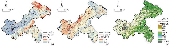
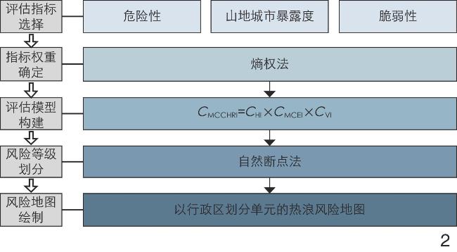
采集社会经济、地理信息和人口数据,识别高温热浪风险要素,构建以“危险性—山地城市暴露度—脆弱性”为框架的山地城市高温热浪风险评估体系,并选择重庆市2018年7—9月典型高温热浪事件展开评估。
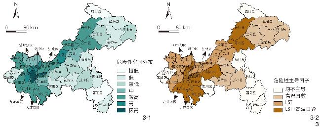
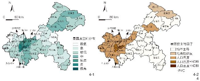
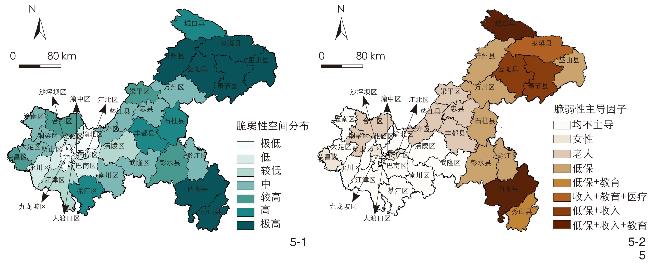
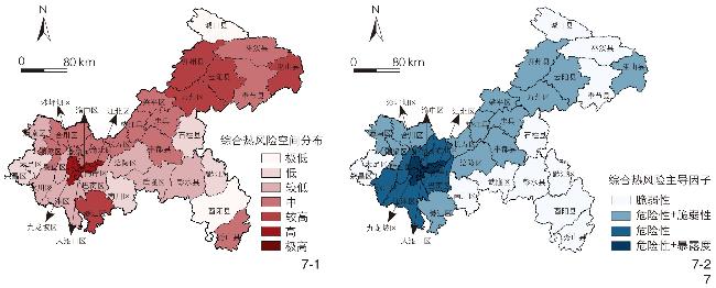
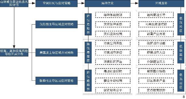
极高和高风险区县都分布在中心城区以内,其高温热浪平均风险水平超出中等级风险区的2倍,由危险性和暴露度共同主导,越靠近中心,综合风险越高;危险性与暴露度都呈“近高远低”的空间分布特征,脆弱性空间分布特征则为“近低远高”;危险性较小的区县往往收入、医疗、教育水平有限,脆弱性明显高于中心城区;根据高温热浪风险主导因子的不同,以“局地优化、区域互补”为思路,提出山地城市热灾害风险应对策略与规划建议。
完善了风景园林应对气候变化的策略体系,推动构建健康、安全、舒适的城市人居环境,为落实山地城市气候韧性发展规划提供理论支持与指导。
黄海静 , 马金辉 , 杨雨飞 . 山地城市高温热浪灾害空间识别与风险评估——以重庆市为例[J]. 风景园林, 2024 , 31(8) : 95 -103 . DOI: 10.3724/j.fjyl.202309210434
This research focuses on addressing the increasingly severe issue of extreme urban heat, driven by climate change, both globally and within China. Recent temperature records highlight the urgent need to understand and mitigate impacts of heat waves. TheSynthesis Report of the Sixth Assessment Report declares a red warning against global climate change, signifying the most perilous stage of climate change, with 18 out of 31 “planetary vital signs” surpassing historical records. The increase in global temperature in the last 50 years has exceeded the total increase over the previous 2,000 years, making the last seven years the hottest on record. While international efforts have initiated risk assessments for heat waves, previous research in China primarily focuses on spatiotemporal analyses based on meteorological data. Recent research has integrated multiple data sources and socio-economic indicators. However, most assessments are conducted regionally, neglecting intricate risk features within urban areas and precise resource allocation guidance. Moreover, research at the county level in China mainly centers on eastern plain cities, overlooking the unique challenges faced by southwestern mountain cities, known for their complex topography and ecosystems, resulting in higher heat wave risks. Chongqing, situated in the upper Yangtze River region, is a typical mountain city notorious for heat waves.
To establish a comprehensive risk assessment system for heat waves in mountain cities, this research employs a risk index model. The approach includes the following steps: Firstly, analyze the fundamental causes of heat wave disasters to understand their mechanisms; secondly, identify risk elements of heat waves, and define and quantify assessment factors to construct integrated assessment indicators; lastly, quantify heat wave risks using a quantitative method to establish a comprehensive risk assessment system for mountainous urban areas. This assessment system is based on the disaster risk assessment framework from theSynthesis Report of the Fifth Assessment Report, which additionally incorporate factors specific to mountainous urban areas such as elevation and terrain variation to accurately reflect its risk characteristics. Notably, the “exposure” factor has been transformed as “mountain city exposure” to enhance its specificity and guidance.
Heat wave risks in Chongqing exhibit significant regional disparities, influenced by varying levels of urbanization. Hazardousness analysis reveals a distribution trend of “higher risk in the west and lower risk in the east” and “higher risk closer to the city center”. Urbanization-related factors, such as artificial surface, high population density, and urban heat island effect, are major contributors to increased hazardousness. Exposure analysis emphasizes high exposure in the central urban area due to increased population density and building coverage, making it more susceptible to heat waves. Key factors dominating exposure include population density, building density, and vegetation coverage. The central urban area exhibits lower vulnerability due to higher income and education level as well as better medical facilities. Conversely, the northeastern and southeastern regions, farther from the city center, experience higher vulnerability due to poorer socioeconomic conditions. To mitigate heat wave risks, the concept of “local optimization and regional complementarity” is proposed. Specific strategies address both intra-regional and inter-regional aspects, solving primary issues while leveraging the advantages of surrounding low-risk areas. For hazardousness-dominated regions, it is advisable to implement emergency plans, adopt long-term measures to address heat wave intensity and frequency, improve heat wave warnings, and strengthen energy systems. For exposure-dominated regions, it is recommended to provide cooling shelters, create cool communities through urban design, and expand urban functions to low-exposure areas. For vulnerability-dominated regions, it is crucial to strengthen social security, enhance care mechanisms for vulnerable populations, and develop the elderly care industry. Additionally, it is important to utilize education and medical resources from the central urban area to disseminate knowledge and provide medical assistance, while also improving living conditions for the elderly.
This research constructs a risk assessment system for heat waves in mountain cities, and maps the spatial distribution of heat risk levels and driving factors. Overall, the strategy system for landscape architecture has been improved in response to climate change, promoting healthier, safer, and more comfortable environments. However, there are some limitations. 1) The scale of urban heat wave risk assessment is mostly concentrated at the city and district levels. Due to the lack of detailed high-temperature data at the subdistrict level from the Chongqing Meteorological Bureau, more refined analysis at the subdistrict level has not yet been conducted. In the future, with improved demographic, meteorological, and socioeconomic data, and the application of technologies such as drone and airship remote sensing, it may be possible to study the spatiotemporal distribution characteristics and risk assessment of heat waves at the subdistrict and community levels. 2) integrating climate models like WRF, ENVI-met, and Fluent will advance the application of climate-resilient landscape architecture techniques in vegetation, terrain, water body, and building. Establishing a strategy system to enhance green infrastructure from the smaller block scale to the larger regional scale will provide a more scientific basis for the construction of climate-resilient cities in China.
表1 山地城市高温热浪风险评估指标体系与数据来源Table 1 Indicators system and data sources for risk assessment of heat waves in mountain cities |
| 目标层 | 准则层 | 评估指标 | 数据来源 |
| 注:+表示该指标为正向指标,−表示该指标为负向指标。 | |||
| 山地城市高温热浪风险评估 | 危险性 | LST/℃+ | Landsat 8 OLI/TIRS卫星数据 |
| 高温日数/d+ | 重庆市气象局高温日数数据 | ||
| 山地城市暴露度 | FVC− | Landsat 8 OLI/TIRS卫星数据 | |
| MNDWI− | Landsat 8 OLI/TIRS卫星数据 | ||
| NDBI+ | Landsat 8 OLI/TIRS卫星数据 | ||
| 人口密度/(人/km2)+ | 重庆市第七次全国人口普查公报 | ||
| 高程/m− | ASTER GDEM 30 m分辨率高程数据 | ||
| 地表起伏度+ | ASTER GDEM 30 m分辨率高程数据 | ||
| 脆弱性 | ≥65岁人口比例/%+ | 重庆市第七次全国人口普查公报 | |
| 常住女性人口比例/%+ | 重庆市第七次全国人口普查公报 | ||
| 城镇常住居民人均可支配收入/元− | 重庆统计年鉴 2020 | ||
| 城市低保人数占常住城镇人口比例/%+ | 重庆统计年鉴 2020 | ||
| 受教育程度为高中以下人口比例/%+ | 重庆市第七次全国人口普查公报 | ||
| 每千常住人口拥有卫生技术人员数/人− | 重庆卫生健康统计年鉴 2020 | ||
| 每千常住人口拥有卫生机构床位数/床− | 重庆卫生健康统计年鉴 2020 | ||
| 医疗机构10 min步行距离覆盖面积比例/%− | 高德地图API | ||
表2 评估指标权重计算结果Table 2 Weight calculation results of assessment indicators |
| 准则层 | 评估指标 | 权重 |
| 危险性 | LST/℃ | 0.593 |
| 高温日数/d | 0.407 | |
| 山地城市暴露度 | 人口密度/(人/km2) | 0.493 |
| NDBI | 0.335 | |
| 地表起伏度 | 0.087 | |
| FVC | 0.048 | |
| 高程/m | 0.025 | |
| MNDWI | 0.011 | |
| 脆弱性 | 城市低保人数占常住城镇人口比例/% | 0.296 |
| 城镇常住居民人均可支配收入/元 | 0.216 | |
| ≥65岁人口比例/% | 0.146 | |
| 常住女性人口比例/% | 0.141 | |
| 受教育程度为高中以下人口比例/% | 0.114 | |
| 医疗机构10 min步行距离覆盖面积比例/% | 0.031 | |
| 每千常住人口拥有卫生机构床位数/床 | 0.029 | |
| 每千常住人口拥有卫生技术人员数/人 | 0.027 |
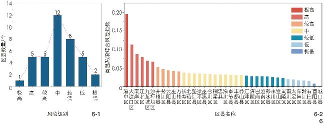
图6 高温热浪风险级别区县数量(6-1)与综合风险指数分析(6-2)Fig. 6 Analysis of the number of counties/districts classified by heat wave risk levels (6-1) and the comprehensive risk index thereof (6-2) |
文中图表均由作者绘制,其中
| [1] |
张宁. 中国将建成气候适应型社会[J]. 生态经济, 2022, 38(8): 9-12.
ZHANG N. Building a Climate-Adaptive Society in China[J]. Ecological Economy, 2022, 38(8): 9-12.
|
| [2] |
孙雨蒙. 地球气候变化已到临界点[J]. 生态经济, 2021, 37(10): 5-8.
SUN Y M. Earth’s Climate Change Reaches a Tipping Point[J]. Ecological Economy, 2021, 37(10): 5-8.
|
| [3] |
王蕾, 张百超, 石英, 等. IPCC AR6报告关于气候变化影响和风险主要结论的解读[J]. 气候变化研究进展, 2022, 18(4): 389-394.
WANG L, ZHANG B C, SHI Y, et al. Interpretation of the Key Findings on Climate Change Impacts and Risks in the IPCC AR6 Report[J]. Advances in Climate Change Research, 2022, 18(4): 389-394.
|
| [4] |
唐韬, 严飞. 过去7年是史上最热7年[J]. 生态经济, 2022, 38(7): 5-8.
TANG T, YAN F. The Past Seven Years Are the Hottest in History[J]. Ecological Economy, 2022, 38(7): 5-8.
|
| [5] |
翟盘茂, 周佰铨, 陈阳, 等. 气候变化科学方面的几个最新认知[J]. 气候变化研究进展, 2021, 17(6): 629-635.
ZHAI P M, ZHOU B Q, CHEN Y, et al. Recent Advances in Climate Change Science[J]. Advances in Climate Change Research, 2021, 17(6): 629-635.
|
| [6] |
许遐祯, 郑有飞, 尹继福, 等. 南京市高温热浪特征及其对人体健康的影响[J]. 生态学杂志, 2011, 30(12): 2815-2820.
XU X Z, ZHENG Y F, YIN J F, et al. Characteristics of High-Temperature Heatwaves in Nanjing City and Their Impacts on Human Health[J]. Chinese Journal of Ecology, 2011, 30(12): 2815-2820.
|
| [7] |
TIAN Z X, LI S S, ZHANG J L, et al. The Characteristic of Heat Wave Effects on Coronary Heart Disease Mortality in Beijing, China: A Time Series Study[J]. PLoS ONE, 2013, 8(9): e77321
|
| [8] |
HE B J, WANG J S, LIU H M, et al. Localized Synergies Between Heat Waves and Urban Heat Islands: Implications on Human Thermal Comfort and Urban Heat Management[J]. Environmental Research, 2021, 193: 110584.
|
| [9] |
SEMENZA J C, RUBIN C H, FALTER K H, et al. Heat-Related Deaths During the July 1995 Heat Wave in Chicago[J]. New England Journal of Medicine, 1996, 335(2): 84-90.
|
| [10] |
HE B J. Cause-Related Injustice, Process-Related Injustice, Effect-Related Injustice and Regional Heat Action Planning Priorities: An Empirical Study in Yangtze River Delta and Chengdu-Chongqing Urban Agglomerations[J]. Landscape and Urban Planning, 2023, 237: 104800.
|
| [11] |
HE B J, ZHAO D X, XIONG K, et al. A Framework for Addressing Urban Heat Challenges and Associated Adaptive Behavior by the Public and the Issue of Willingness to Pay for Heat Resilient Infrastructure in Chongqing, China[J]. Sustainable Cities and Society, 2021, 75: 103361.
|
| [12] |
HÜBLER M, KLEPPER G, PETERSON S. Costs of Climate Change: The Effects of Rising Temperatures on Health and Productivity in Germany[J]. Ecological Economics, 2008, 68(1): 381-393.
|
| [13] |
ZANDER K K, BOTZEN W J W, OPPERMANN E, et al. Heat Stress Causes Substantial Labour Productivity Loss in Australia[J]. Nature Climate Change, 2015, 5(7): 647-651.
|
| [14] |
税伟, 陈志淳, 邓捷铭, 等. 耦合适应力的福州市高温脆弱性评估[J]. 地理学报, 2017, 72(5): 830-849.
SHUI W, CHEN Z C, DENG J M, et al. Assessment of Fuzhou City’s High-Temperature Vulnerability Considering Coupled Adaptation Stress[J]. Acta Geographica Sinica, 2017, 72(5): 830-849.
|
| [15] |
孙澄, 解文龙. 气候韧性导向的严寒地区城市设计框架: 以长春市总体城市设计为例[J]. 风景园林, 2021, 28(8): 39-44.
SUN C, XIE W L. Climate Resilience Oriented Urban Design Framework for Cities in Severe Cold Regions: A Case Study of General Urban Design of Changchun[J]. Landscape Architecture, 2021, 28(8): 39-44.
|
| [16] |
刘长松. 气候变化背景下风景园林的功能定位及应对策略[J]. 风景园林, 2020, 27(12): 75-79.
LIU C S. Functional Orientation and Countermeasures of Landscape Architecture Under the Background of Climate Change[J]. Landscape Architecture, 2020, 27(12): 75-79.
|
| [17] |
DOUSSET B, GOURMELON F. Satellite Multi-sensor Data Analysis of Urban Surface Temperatures and Landcover[J]. ISPRS Journal of Photogrammetry and Remote Sensing, 2003, 58(1): 43-54.
|
| [18] |
INOSTROZA L, PALME M, BARRERA F D L. A Heat Vulnerability Index: Spatial Patterns of Exposure, Sensitivity and Adaptive Capacity for Santiago de Chile[J]. PLoS ONE, 2016, 11(9): e0162464
|
| [19] |
KRÜGER T, HELD F, HOECHSTETTER S, et al. A New Heat Sensitivity Index for Settlement Areas[J]. Urban Climate, 2013, 6: 63-81.
|
| [20] |
郑有飞, 丁雪松, 吴荣军, 等. 近50年江苏省夏季高温热浪的时空分布特征分析[J]. 自然灾害学报, 2012, 21(2): 43-50.
ZHENG Y F, DING X S, WU R J, et al. Analysis of the Spatiotemporal Distribution Characteristics of Summer High-Temperature Heatwaves in Jiangsu Province over the Past 50 Years[J]. Journal of Natural Disasters, 2012, 21(2): 43-50.
|
| [21] |
张曦, 黎鑫. 湖南省夏季高温热浪时空分布特征及其成因[J]. 气候与环境研究, 2017, 22(6): 747-756.
ZHANG X, LI X. Spatial and Temporal Distribution Characteristics and Causes of Summer High-Temperature Heatwaves in Hunan Province[J]. Climatic and Environmental Research, 2017, 22(6): 747-756.
|
| [22] |
李琪, 苏欢, 史雨涵, 等. 1961~2010年江浙沪地区夏季高温热浪时空变化特征[J]. 长江流域资源与环境, 2016, 25(3): 506-513.
LI Q, SU H, SHI Y H, et al. Spatial and Temporal Variation Characteristics of Summer High-Temperature Heatwaves in the Yangtze River Delta Region from 1961 to 2010[J]. Resources and Environment in the Yangtze Basin, 2016, 25(3): 506-513.
|
| [23] |
付含聪, 邓帆, 杨欢, 等. 基于遥感的长江中下游城市群高温热浪风险评估[J]. 长江流域资源与环境, 2020, 29(5): 1174-1182.
FU H C, DENG F, YANG H, et al. Risk Assessment of High-Temperature Heatwaves in the Urban Agglomeration of the Middle and Lower Reaches of the Yangtze River Based on Remote Sensing[J]. Resources and Environment in the Yangtze Basin, 2020, 29(5): 1174-1182.
|
| [24] |
陈倩, 丁明军, 杨续超, 等. 长江三角洲地区高温热浪人群健康风险评价[J]. 地球信息科学学报, 2017, 19(11): 1475-1484.
CHEN Q, DING M J, YANG X C, et al. Health Risk Assessment of High-Temperature Heatwaves in the Yangtze River Delta Region[J]. Journal of Geo-Information Science, 2017, 19(11): 1475-1484.
|
| [25] |
周波涛, 徐影, 韩振宇, 等. “一带一路”区域未来气候变化预估[J]. 大气科学学报, 2020, 43(1): 255-264.
ZHOU B T, XU Y, HAN Z Y, et al. Future Climate Change Projection in the “Belt and Road” Region[J]. Journal of Atmospheric Sciences, 2020, 43(1): 255-264.
|
| [26] |
何苗, 徐永明, 李宁, 等. 基于遥感的北京城市高温热浪风险评估[J]. 生态环境学报, 2017, 26(4): 635-642.
HE M, XU Y M, LI N, et al. Risk Assessment of Urban High-Temperature Heatwaves in Beijing Based on Remote Sensing[J]. Journal of Ecology and Environmental Sciences, 2017, 26(4): 635-642.
|
| [27] |
陈恺, 唐燕. 城市高温热浪脆弱性空间识别与规划策略应对: 以北京中心城区为例[J]. 城市规划, 2019, 43(12): 37-44.
CHEN K, TANG Y. Spatial Identification of Urban High-Temperature Heatwave Vulnerability and Planning Strategies: A Case Study of Beijing’s Central City[J]. City Planning Review, 2019, 43(12): 37-44.
|
| [28] |
郑颖生, 王墨, 李建军, 等. 城市高温风险评估与气候适应性规划策略: 以亚热带高密度城市深圳为例[J]. 规划师, 2021, 37(14): 13-19.
ZHENG Y S, WANG M, LI J J, et al. Risk Assessment of Urban High-Temperature Events and Climate Adaptation Planning Strategies: A Case Study of Shenzhen, A Subtropical High-Density City[J]. Planners, 2021, 37(14): 13-19.
|
| [29] |
杨林川, 杨皓森, 范强雪, 等. 大城市高温热浪脆弱性评价及规划应对研究: 以成都市为例[J]. 规划师, 2023, 39(2): 38-45.
YANG L C, YANG H S, FAN Q X, et al. Vulnerability Assessment and Planning Response to High-Temperature Wave in Large Cities: The Case of Chengdu[J]. Planners, 2023, 39(2): 38-45.
|
| [30] |
王丹舟, 张强, 朱秀迪, 等. 基于多源数据的上海市高温热浪风险评估[J]. 北京师范大学学报(自然科学版), 2021, 57(5): 613-623.
WANG D Z, ZHANG Q, ZHU X D, et al. Risk Assessment of High-Temperature Heatwaves in Shanghai Based on Multi-source Data[J]. Journal of Beijing Normal University (Natural Science), 2021, 57(5): 613-623.
|
| [31] |
苏王新, 常青. 城市热缓解的基于自然的解决方案与实施路径: 以北京市为例[J]. 风景园林, 2022, 29(6): 26-32.
SU W X, CHANG Q. Nature-Based Solutions for Urban Heat Mitigation and Implementation Path Thereof: A Case Study of Beijing[J]. Landscape Architecture, 2022, 29(6): 26-32.
|
| [32] |
熊亚军, 于平, 扈海波. 国内高温气候变化事实及其灾害特征研究进展[J]. 干旱气象, 2013, 31(1): 194-198.
XIONG Y J, YU P, HU H B. Research Progress on Facts and Disaster Characteristics of High-Temperature Climate Change in China[J]. Journal of Arid Meteorology, 2013, 31(1): 194-198.
|
| [33] |
徐煜辉, 张文涛. “适应”与“缓解”: 基于微气候循环的山地城市低碳生态住区规划模式研究[J]. 城市发展研究, 2012, 19(7): 156-160.
XU Y H, ZHANG W T. “Adaptation” and “Mitigation”: Research on the Planning Mode of Low-Carbon Ecological Residential Areas in Mountainous Urban Areas Based on Microclimate Circulation[J]. Urban Development Studies, 2012, 19(7): 156-160.
|
| [34] |
曾穗平, 田健. 山地城市微气候特点与热岛效应缓解策略研究[J]. 建筑学报, 2013(S2): 106-109.
ZENG S P, TIAN J. Research on Microclimate Characteristics and Heat Island Effect Mitigation Strategies in Mountain Cities[J]. Journal of Architecture, 2013(S2): 106-109.
|
| [35] |
黄晓军, 王博, 刘萌萌, 等. 中国城市高温特征及社会脆弱性评价[J]. 地理研究, 2020, 39(7): 1534-1547.
HUANG X J, WANG B, LIU M M, et al. Characteristic of Urban High Temperatures and Social Vulnerability Assessment in China[J]. Geographical Research, 2020, 39(7): 1534-1547.
|
| [36] |
LUO X, YANG J, SUN W, et al. Suitability of Human Settlements in Mountainous Areas from the Perspective of Ventilation: A Case Study of the Main Urban Area of Chongqing[J]. Journal of Cleaner Production, 2021, 310: 127467.
|
| [37] |
武夕琳, 刘庆生, 刘高焕, 等. 高温热浪风险评估研究综述[J]. 地球信息科学学报, 2019, 21(7): 1029-1039.
WU X L, LIU Q S, LIU G H, et al. A Review of High-Temperature Heatwave Risk Assessment Research[J]. Journal of Geo-Information Science, 2019, 21(7): 1029-1039.
|
| [38] |
HEATON M J, SAIN S R, GREASBY T A, et al. Characterizing Urban Vulnerability to Heat Stress Using a Spatially Varying Coefficient Model[J]. Spatial and Spatio-Temporal Epidemiology, 2014, 8: 23-33.
|
| [39] |
乔治, 田光进. 基于MODIS的2001年—2012年北京热岛足迹及容量动态监测[J]. 遥感学报, 2015, 19(3): 476-484.
QIAO Z, TIAN G J. Monitoring the Dynamic Changes of Urban Heat Island Footprint and Capacity in Beijing from 2001 to 2012 Based on MODIS[J]. Journal of Remote Sensing, 2015, 19(3): 476-484.
|
| [40] |
刘勇洪, 权维俊. 北京城市高温遥感指标初探与时空格局分析[J]. 气候与环境研究, 2014, 19(3): 332-342.
LIU Y H, QUAN W J. Preliminary Exploration of Remote Sensing Indicators for Urban High Temperatures in Beijing and Analysis of Spatiotemporal Patterns[J]. Climatic and Environmental Research, 2014, 19(3): 332-342.
|
| [41] |
WAN Z M, ZHANG Y L, ZHANG Q C, et al. Validation of the Land-Surface Temperature Products Retrieved from Terra Moderate Resolution Imaging Spectroradiometer Data[J]. Remote Sensing of Environment, 2002, 83(1): 163-180.
|
| [42] |
ROMERO L P, QIN H, DICKINSON K. Urban Vulnerability to Temperature-Related Hazards: A Meta-Analysis and Meta-Knowledge Approach[J]. Global Environmental Change, 2012, 22(3): 670-683.
|
| [43] |
WILHELMI O V, HAYDEN M H. Connecting People and Place: A New Framework for Reducing Urban Vulnerability to Extreme Heat[J]. Environmental Research Letters, 2010, 5(1): 014021
|
| [44] |
祁新华, 程煜, 李达谋, 等. 西方高温热浪研究述评[J]. 生态学报, 2016, 36(9): 2773-2778.
QI X H, CHENG Y, LI D M, et al. A Review of Western Research on High-Temperature Heatwaves[J]. Acta Ecologica Sinica, 2016, 36(9): 2773-2778.
|
| [45] |
ELZEIN A, TONMOY F N. Assessment of Vulnerability to Climate Change Using a Multi-criteria Outranking Approach with Application to Heat Stress in Sydney[J]. Ecological Indicators, 2015, 48: 207-217.
|
| [46] |
薛倩, 谢苗苗, 郭强, 等. 地理学视角下城市高温热浪脆弱性评估研究进展[J]. 地理科学进展, 2020, 39(4): 685-694.
XUE Q, XIE M M, GUO Q, et al. Research Progress on Vulnerability Assessment of Urban High-Temperature Heatwaves from the Perspective of Geography[J]. Progress in Geography, 2020, 39(4): 685-694.
|
| [47] |
BRADFORD K, ABRAHAMS L, HEGGLIN M, et al. A Heat Vulnerability Index and Adaptation Solutions for Pittsburgh, Pennsylvania[J]. Environmental Science & Technology, 2015, 49(19): 11303-11311.
|
| [48] |
GILBERT H, MANDEL B H, LEVINSON R. Keeping California Cool: Recent Cool Community Developments[J]. Energy and Buildings, 2016, 114: 20-26.
|
| [49] |
游晓婕, 李琼, 孟庆林. 城市热岛空间格局及形态差异化调控策略研究: 以广州市中心城区为例[J]. 风景园林, 2021, 28(5): 74-79.
YOU X J, LI Q, MENG Q L. Research on Spatial Patterns and Morphological Differentiation Control Strategy of Urban Heat Islands: A Case Study of Downtown Area of Guangzhou City[J]. Landscape Architecture, 2021, 28(5): 74-79.
|
| [50] |
宋姗, 王德, 朱玮, 等. 基于需求偏好的上海市养老机构空间配置研究[J]. 城市规划, 2016, 40(8): 77-82.
SONG S, WANG D, ZHU W, et al. Research on the Spatial Configuration of Elderly Care Institutions in Shanghai Based on Demand Preferences[J]. Urban Planning, 2016, 40(8): 77-82.
|
| [51] |
孟庆林, 王频, 李琼. 城市热环境评价方法[J]. 中国园林, 2014, 30(12): 13-16.
MENG Q L, WANG P, LI Q. Evaluation Methods for Urban Thermal Environment[J]. Chinese Landscape Architecture, 2014, 30(12): 13-16.
|
/
| 〈 |
|
〉 |