
“山-城”互眺关系中的福建省泉州市清源山片区建筑高度管控策略
|
张兵华/男/博士/福州大学建筑与城乡规划学院讲师、硕士生导师/古建筑保护福建省高校工程研究中心副主任/研究方向为城乡公共空间、空间图式语言、防御性聚落与建筑、历史街区保护与微更新 |
|
祝昱翔/男/福州大学建筑与城乡规划学院在读硕士研究生/研究方向为历史建成环境规划与设计 |
|
郑承智/男/硕士/福建省城乡规划设计研究院国土资源利用研究所所长/研究方向为城乡规划与设计 |
|
许广通/男/博士/福州大学建筑与城乡规划学院讲师、硕士生导师/古建筑保护福建省高校工程研究中心副研究员/研究方向为城乡文化遗产保护、历史建成环境规划与设计 |
Copy editor: 刘昱霏
收稿日期: 2023-09-15
修回日期: 2024-05-17
网络出版日期: 2025-12-17
基金资助
国家自然科学基金青年科学基金项目“传统村落公共空间的图式语言分析方法及设计应用——以闽江流域为例”(52208013)
国家自然科学基金“区域历史文化聚落的关联图式识别与遗产体系建构研究——以荆襄历史廊道地区为例”(52308054)
版权
Building Height Control Strategy for Qingyuan Mountain Area in Quanzhou, Fujian in the Relationship of “Mountain − City” Overlooking
|
ZHANG Binghua, Ph.D., is a lecturer and a master supervisor in the School of Architecture and Urban-Rural Planning, Fuzhou University, and deputy director of Fujian University Engineering Research Center for the Conservation of Ancient Buildings. His research focuses on urban and rural public space, spatial schema language, defensive settlements and architecture, and conservation and renewal of historical blocks |
|
ZHU Yuxiang is a master student in the School of Architecture and Urban-Rural Planning, Fuzhou University. His research focuses on planning and design of historical built environment |
|
ZHENG Chengzhi, Master, is director of the Institute of Land Resources Utilization, Fujian Urban and Rural Planning and Design Institute. His research focuses on urban-rural planning and design |
|
XU Guangtong, Ph.D., is a lecturer and a master supervisor in the School of Architecture and Urban-Rural Planning, Fuzhou University, and deputy researcher of Fujian University Engineering Research Center for the Conservation of Ancient Buildings. His research focuses on conservation of urban and rural cultural heritage, and planning and design of historical built environment |
Received date: 2023-09-15
Revised date: 2024-05-17
Online published: 2025-12-17
Copyright
“山-城”眺望景观作为传统营城思想与山水环境互动形成的有机整体,对其管控可落实新时期国土空间规划对山水环境保护开发的整体要求,建筑高度管控则是重要抓手。在“山-城”互眺关系中探索建筑高度管控策略,正成为解决城市高度碎片化、均等化等管控弊端的有效路径。
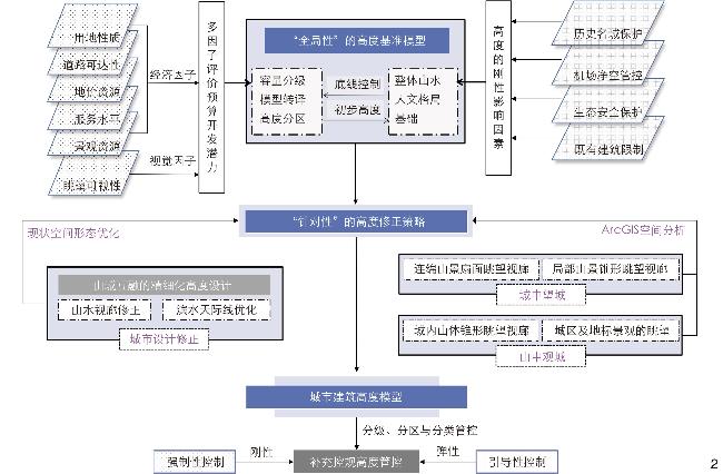
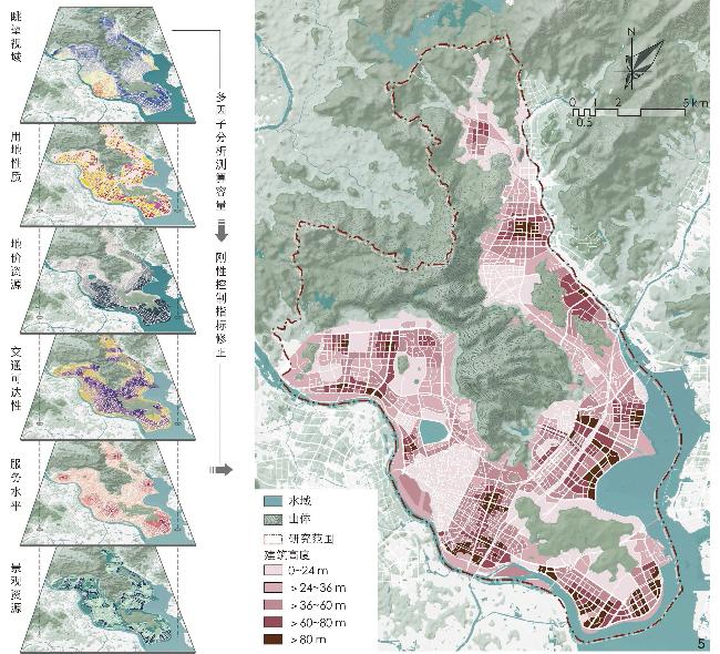
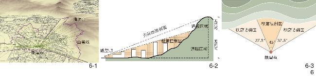
以福建省泉州市清源山片区为例,运用视域分析和街景识别技术构建“山-城”眺望体系;而后在“山-城”互眺关系中,综合运用层次分析法和ArcGIS空间叠加分析法,选取多因子变量,建立高度管控的基准模型;进而针对特定要素,突出“城望山”自然景廊和“山观城”人文地标,对基准模型进行修正。
得到清源山片区建筑高度分区管控方案,并提出分级、分区与分类的针对性管控措施及要求。
“山-城”互眺关系中的建筑高度整体管控模型与多梯度修正策略,能够在“刚弹结合”的规划中提升建筑高度管控的全局性与针对性。
张兵华 , 祝昱翔 , 郑承智 , 许广通 . “山-城”互眺关系中的福建省泉州市清源山片区建筑高度管控策略[J]. 风景园林, 2024 , 31(7) : 122 -130 . DOI: 10.3724/j.fjyl.202309150422
The “mountain − city” overlooking landscape is an organic whole formed by the long-term interaction between traditional city construction thoughts and local landscape environment, which contains both urban cultural characteristics and human settlement wisdom. The control of the “mountain − city” overlooking landscape meets the overall requirements of the new period of territorial spatial planning for the development of landscape environment protection, and can provide the basic logic for the control of urban construction, while the control of building height is an important lever and policy tool to show the characteristics of the “mountain − city” relationship. Therefore, in combination with the project practice of the Guidelines for the Protection and Use of Qingyuan Mountain and the Coordination of Regional Construction Control, and on the basis of traditional research on building height control, this research takes the “mountain − city” overlooking as the logical starting point and planning reference to explore the construction scheme and application technology of the building height control model based on the combination of rigidity and elasticity, with the aim of enhancing the globality and pertinence of urban spatial control, and improving the overall control of urban space, while providing methodological guidance and case study for the construction practice of similar cities.
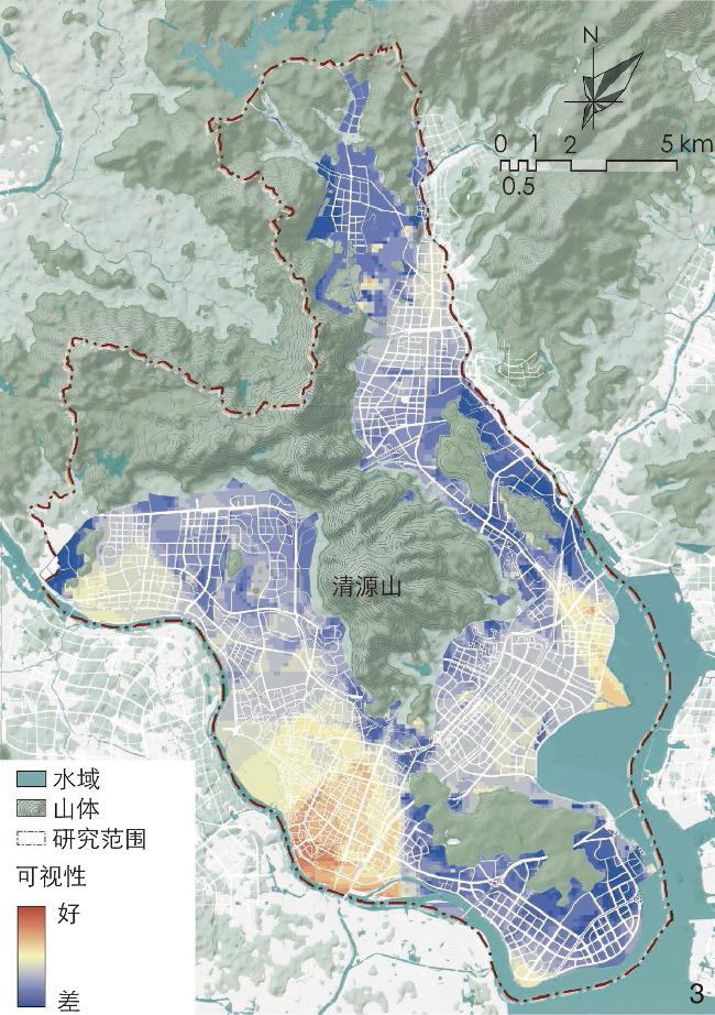
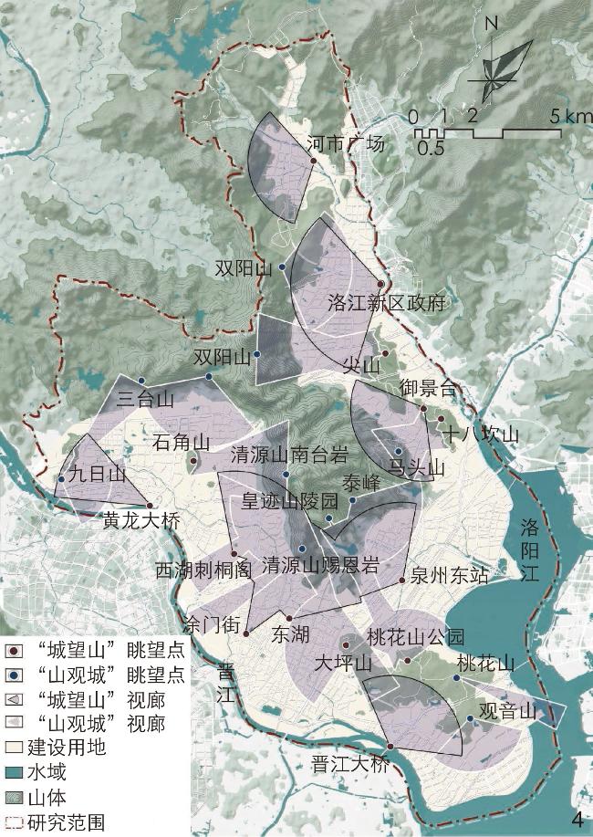
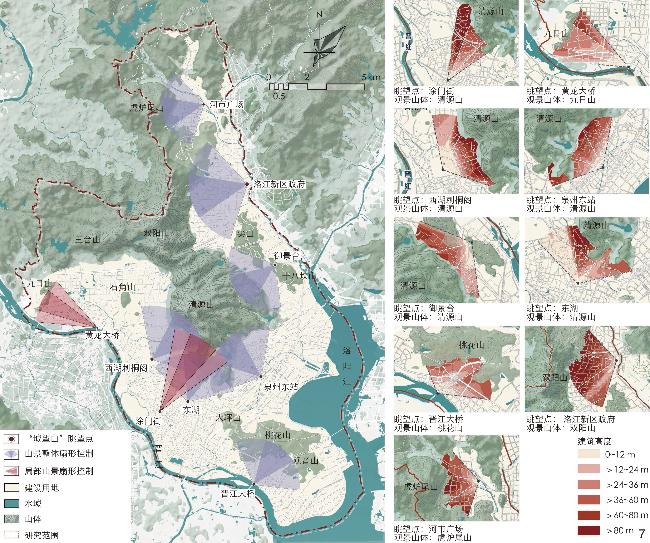
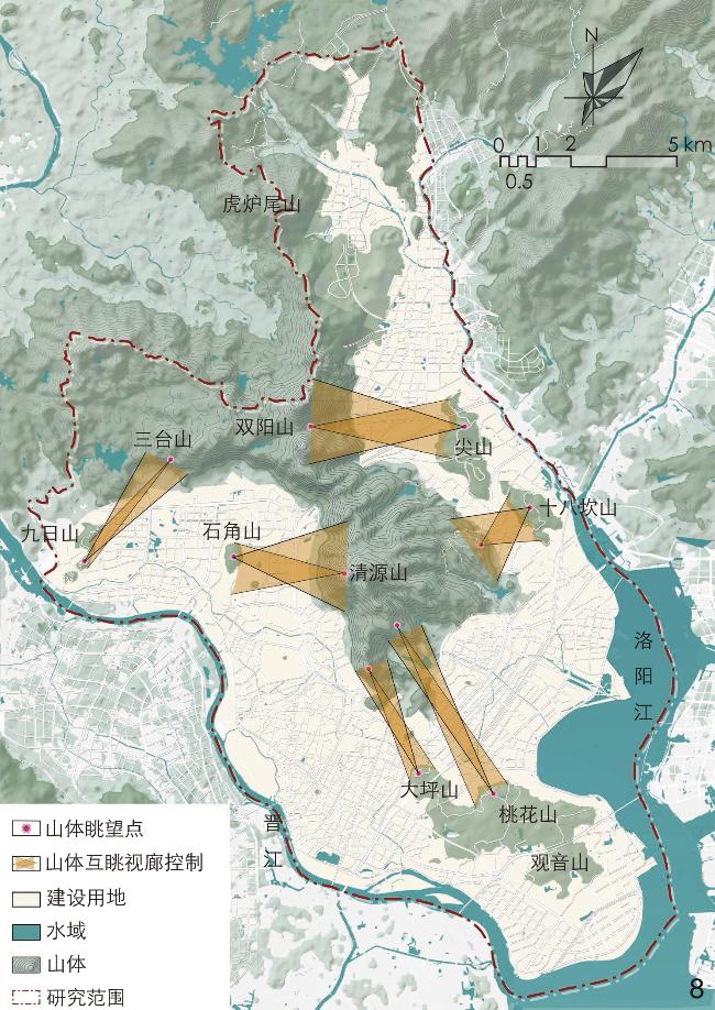
Taking Qingyuan Mountain Area in Quanzhou as an example, this research firstly makes an overview of the landscape and humanity pattern of the urban area, the changes of the urban and landscape environment, and the problems currently faced by the city, and analyzes the spatial characteristics and current status of cityscape control in Quanzhou. Secondly, through the literature research method, the research lists the methods and case practices of building height control, so as to construct a building height control system based on the “mountain − city” overlooking in combination with the characteristics of Qingyuan Mountain Area in Quanzhou. Thirdly, when constructing a holistic “mountain − city” overlooking system in Qingyuan Mountain Area, this research uses the GIS view analysis method to analyze the view of multiple viewpoints, so as to determine the landscape viewing corridor, and uses the deep learning pattern recognition method to analyze the perception of mountain in Qingyuan Mountain Area, so as to select the landscape viewpoints in the urban public space. In the overall mountain − city relationship, AHP hierarchical analysis and GIS spatial superposition analysis are used to select multi-factor variables to measure the capacity of urban development, which is then translated into a benchmark model for height control based on a reasonable threshold; in the specific landscape and humanity elements, the building height control strategy is centred on the two perspectives of “mountain overlooking from the city” and “city overlooking from the mountain”. Based on the line-of-sight protection of natural landscape corridors and humanity landmarks, the GIS skyline analysis tool is used to calculate the elevation values of the places within the limiting surfaces, and the baseline model is corrected by quantitative data, in order to determine quantitative indicators for building height control in Qingyuan Mountain Area.
The results show that the correction strategy based on the “mountain−city” overlooking system can effectively correct the distribution of building height under the perspective of single development capacity, and the control strategy plays a certain role in controlling building height in the ancient urban area, the built-up area and the mountain area of Quanzhou. The control results should also be considered to ensure the legal benefits of relevant control regulations. Additionally, the building height model should follow the principle of combining rigidity and elasticity, the control requirements of grading and classification should be refined, and corresponding control conditions should be put forward, so as to improve relevant indicators of building height in the control regulations.
With the help of relevant spatial analysis technology models and methods, this research improves the global and systematic building height control in the overall relationship of “mountain − city” overlooking and then refines the pertinence and differentiation of the control over different areas by the overlooking system in the element guidance of grading, classification and zoning. The urban building height benchmark model and its correction strategy are constructed from the two levels of overall relationship and local elements, and then applied to the practice of local building height control, which is also of great significance for other coastal mountain cities similar to Quanzhou to break through spatial governance dilemmas. At the same time, the building height control model constructed in this research needs to be constantly tested and revised in more urban height control practices, and future research needs to be optimized and improved in terms of the immediacy of data and the multi-sample comparative analysis.
表1 建筑高度管控技术方法比较一览表Tab. 1 Comparison list of building height control technologies and methods |
| 建筑高度控制方法 | 管控对象 | 应用城市 | 目的 | 优势 | 局限 |
| 城市高度分区管控法 | 古城 | 京都、北京、西安、长沙 | 保护与营造总体城市景观 | 保证核心景观空间形态在整体层面的主导地位 | 缺乏量化分析(如视线影响) |
| 城市历史景观 | 纽约 | ||||
| 视线廊道控制法 | 山体景观 | 香港、舟山、武夷山、伦敦、 巴黎、温哥华、蒙特利尔 | 山水、历史景观的视线保护与城市形象塑造 | 提出形态控制要求,保护城市景观要素的视觉可见性 | 视线范围外街区的建筑高度控制合理性不足 |
| 城市历史景观 | 武汉、南京 | ||||
| 多因子要素分析法 | 城市建成区 | 南京、长沙、郑州 | 从用地潜力视角满足高度布局需求 | 以经济原则分析、测算并转译为高度布局 | 单一效益驱动,对城市特色的考虑不足 |
| 容量测算与视觉分析相结合的方法 | 城市建成区、 山体景观 | 张家界、华阴 | 多维视角下的综合控制 | 协调城市发展与景观保护的关系,适用于一般城市的高度管控需求 | 城市的差异性使该方法还需进一步完善 |
表2 视觉评价的多因子分析指标体系Tab. 2 Multi-factor analysis index system of visual evaluation |
| 评价指标因子 | 属性分级 | 等级赋值 | 因子权重 |
| 可视性 | 最佳 | 10 | 0.1973 |
| 较好 | 7 | ||
| 一般 | 4 | ||
| 差 | 1 | ||
| 用地性质 | 商业用地 | 10 | 0.2658 |
| 居住用地 | 7 | ||
| 公共服务设施用地 | 4 | ||
| 其他 | 1 | ||
| 交通可达性 | 强 | 10 | 0.1565 |
| 较强 | 7 | ||
| 较弱 | 4 | ||
| 弱 | 1 | ||
| 景观资源 | 好 | 10 | 0.0912 |
| 较好 | 7 | ||
| 一般 | 4 | ||
| 差 | 1 | ||
| 服务水平 | 好 | 10 | 0.1243 |
| 较好 | 7 | ||
| 一般 | 4 | ||
| 差 | 1 | ||
| 地价资源 | Ⅰ | 10 | 0.1649 |
| Ⅱ | 7 | ||
| Ⅲ | 4 | ||
| Ⅳ | 1 |
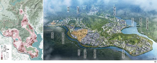
图15 清源山片区最终高度分区(15-1)及三维空间形态示意(15-2)Fig. 15 Schematic diagram of the final height division (15-1) and three-dimensional space form (15-2) of Qingyuan Mountain Area |
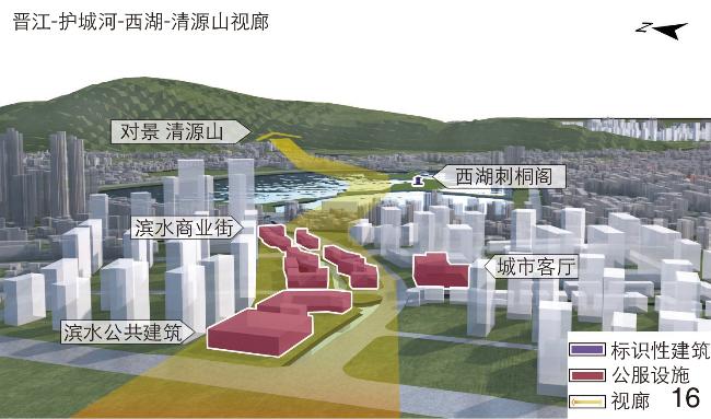
图16 视线廊道高度形态优化示意图Fig. 16 Schematic diagram of height form optimization of line-of-sight corridor |
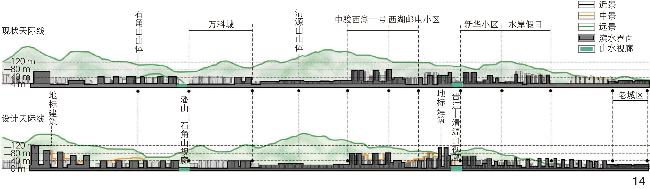
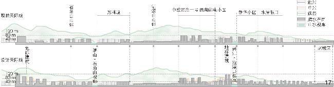
图17 晋江黄龙大桥—笋江大桥段城市天际线高度形态优化Fig. 17 Height form optimization of urban skyline in Jinjiang Huanglong Bridge − Sunjiang Bridge section |
图18 清源山片区最终高度分区(18-1)及三维空间形态示意(18-2)Fig. 18 Schematic diagram of the final height division (18-1) and three-dimensional space form (18-2) of Qingyuan Mountain Area |
表3 清源山片区高度分区管控措施Tab. 3 Measurement of height zoning control in Qingyuan Mountain Area |
| 高度分区、分级控制 | 管控区域 | 管控措施 | 具体要求 |
| 强制性控制 | 存量开发区:历史文化名城范围、生态保护区域、机场净空区、市政设施 | 建筑限高 | 控制历史名城保护范围内建筑高度的上限,新建建筑整体低于20 m,过高建筑予以拆除(净空区高度在爬升面与水平面限高以下);控制滨水廊道建筑高度的上限,滨江第一界面建筑高度控制在24 m以下,第二界面建筑高度控制在36~54 m |
| 引导性控制 | 增量开发区:规划标识性建筑、重要高层簇群区域、重点段天际线 | 建筑限高、建筑限低 | 控制多数(≥75%)建筑的高度上限以及标识建筑高度下限 |
| 控制基准高度、错落度 | 限制区域内的建筑基准平均高度;保证连续的城市界面具有一定错落度 |
| [1] |
柯彦, 林月彬, 林碧英, 等. 基于ArcGIS的“登山观城”眺望景观优化控制研究: 以福州福道为例[J]. 中国园林, 2021, 37(12): 43-47.
KE Y, LIN Y B, LIN B Y, et al. Research on the Optimization Control of Overlooking Landscape from Mountain to City: A Case Study of Fu Forest Trail in Fuzhou[J]. Chinese Landscape Architecture, 2021, 37(12): 43-47.
|
| [2] |
杨洁, 乔杰, 洪亮平. 山地县城高度形态管控的绿色低碳路径探索: 以浙江省永嘉县上塘中心城区为例[J]. 城市规划, 2023, 47(5): 106-120.
YANG J, QIAO J, HONG L P. The Green and Low-Carbon Approach to the Height form Control of Mountainous County: A Case Study on Shangtang Central Urban Area of Yongjia County, Zhejiang Province[J]. City Planning Review, 2023, 47(5): 106-120.
|
| [3] |
高源, 王建国, 张愚. 实操视角下南京老城建筑高度管控: 基于风貌保护的南京老城空间形态城市设计高度研究[J]. 城市规划, 2021, 45(7): 59-66.
GAO Y, WANG J G, ZHANG Y. Practice-Oriented Height Control for the Old City of Nanjing: Height Research in Urban Design of the Old City of Nanjing Based on Landscape Preservation[J]. City Planning Review, 2021, 45(7): 59-66.
|
| [4] |
顾大治, 王彬. 城市高度形态模型构建及管控体系研究[J]. 城市发展研究, 2019, 26(12): 68-76.
GU D Z, WANG B. Study on the Construction and Control System of Urban Height Form Model[J]. Urban Development Studies, 2019, 26(12): 68-76.
|
| [5] |
俞静. 总体城市设计中城市高度管控方法评析和实践探索[J]. 城市规划学刊, 2020(4): 97-105.
YU J. Methods and Practice of Urban Height Management and Control in Comprehensive Urban Design[J]. Urban Planning Forum, 2020(4): 97-105.
|
| [6] |
施婷婷, 徐涵秋, 王帅, 等. 海上丝绸之路起点: 泉州港岸线变化的遥感动态研究[J]. 地球信息科学学报, 2017, 19(3): 407-416.
SHI T T, XU H Q, WANG S, et al. Remote Sensing Study of Coastline Dynamics of Quanzhou Port: Starting Point of the Ancient Maritime Silk Road[J]. Journal of Geo-information Science, 2017, 19(3): 407-416.
|
| [7] |
周剑云, 黎淑翎, 戚冬瑾, 等. 《1961纽约区划则例》立法目的及其实施路线[J]. 城市规划, 2020, 44(10): 102-113.
ZHOU J Y, LI S L, QI D J, et al. Legislative Purpose and Implementation Route of the 1961 New York Zoning Resolution[J]. City Planning Review, 2020, 44(10): 102-113.
|
| [8] |
刘泉, 潘仪, 赖亚妮. 滨海城市山海眺望景观规划控制的日本经验[J]. 国际城市规划, 2019, 34(4): 92-101.
LIU Q, PAN Y, LAI Y N. View Planning Management Between Mountain and Sea of Coastal Cities: The Experience of Japan[J]. Urban Planning International, 2019, 34(4): 92-101.
|
| [9] |
陈煊, 廖艳红, 王嘉骥. 丘陵城市建筑高度控制规划方法构建: 以长沙岳麓山及其周边地区高度控制规划为例(2003—2016)[J]. 城市规划, 2017, 41(9): 64-72.
CHEN X, LIAO Y H, WANG J J. Building Height Control System Based on Hilly City Design: A Case Study of Yuelu Mountain in Changsha and Its Surrounding Area Height Control Planning (2003—2016)[J]. City Planning Review, 2017, 41(9): 64-72.
|
| [10] |
宣建华. 美国纽约区划制度在旧城保护上的意义[J]. 建筑学报, 2020, 22(S2): 115-119.
XUAN J H. The Meaning of America New York Zoning Ordinance in Inner City Conservation[J]. Architectural Journal, 2020, 22(S2): 115-119.
|
| [11] |
贺鼎, 胡萍. 历史城市眺望景观保护管理体系研究: 以英国伦敦为例[J]. 风景园林, 2020, 27(8): 97-102.
HE D, HU P. Research on View Protection and Management System of Historic Cities: A Case Study of London, UK[J]. Landscape Architecture, 2020, 27(8): 97-102.
|
| [12] |
王卓娃. 欧洲多层面控制建筑高度的方法研究[J]. 规划师, 2006, 22(11): 98-101.
WANG Z W. Methodological Study on Multilayer Building Height Control in Europe[J]. Planners, 2006, 22(11): 98-101.
|
| [13] |
涂胜杰, 刘奇志. 城市地标的视线管控思路与方法: 以武汉市黄鹤楼视线保护规划为例[J]. 规划师, 2017, 33(3): 63-70.
TU S J, LIU Q Z. Visual Control of Landmarks: Yellow Crane Tower, Wuhan[J]. Planners, 2017, 33(3): 63-70.
|
| [14] |
Mayor of Montreal. Montréal Master Plan[EB/OL]. (2004-11)[2024-05-23]. https://ville.montreal.qc.ca/portal/page?_pageid=2762,3099656&_dad=portal&_schema=PORTAL.
|
| [15] |
殷铭, 周俊汝, 薛杰, 等. 总体城市设计中山体景观眺望体系构建研究: 以武夷山市为例[J]. 风景园林, 2017, 24(12): 101-106.
YIN M, ZHOU J R, XUE J, et al. Research of Overlook System on Mountain Landscape in Overall Urban Planning: A Case Study of the City of Wuyishan[J]. Landscape Architecture, 2017, 24(12): 101-106.
|
| [16] |
钮心毅, 宋小冬, 陈晨. 保护山体背景景观的建筑高度控制方法及其实现技术[J]. 上海城市规划, 2014(5): 92-97.
NIU X Y, SONG X D, CHEN C. Developing Building Height Restriction for Preserving Views to Mountain Backdrop[J]. Shanghai Urban Planning Review, 2014(5): 92-97.
|
| [17] |
王建国, 高源, 胡明星. 基于高层建筑管控的南京老城空间形态优化[J]. 城市规划,2005(1):45-51, 97-98.
WANG J G, GAO Y, HU M X. Optimization of the Spatial Form for Nanjing Old Area Based on the Guidance and Management of High-Rise Buildings[J]. City Planning Review,2005(1):45-51, 97-98.
|
| [18] |
杨俊宴. 城市空间形态分区的理论建构与实践探索[J]. 城市规划, 2017, 41(3): 41-51.
YANG J Y. Theoretical Construction and Practical Exploration of Urban Spatial Form Partition[J]. City Planning Review, 2017, 41(3): 41-51.
|
| [19] |
杨洁, 乔杰. “山-城”视觉互馈下山地小城市高度形态管控方法研究[J]. 风景园林, 2021, 28(9): 82-89.
YANG J, QIAO J. Research on Vertical Form Control Methods of Small Mountainous City Under “Mountain-City” Visual Interactions[J]. Landscape Architecture, 2021, 28(9): 82-89.
|
| [20] |
黄明华, 刘伟凯, 马琰, 等. 山城一体背景下城市总体建筑高度控制策略: 以华阴市为例[J]. 规划师, 2015, 31(6): 62-66.
HUANG M H, LIU W K, MA Y, et al. General Building Height Control Strategies with Mountain-City Integration[J]. Planners, 2015, 31(6): 62-66.
|
| [21] |
许乙青, 陈丹阳, 栗梦悦. 基于“容量测算—形态修正”的张家界城市建筑高度定量控制研究[J]. 规划师, 2020, 36(1): 38-46.
XU Y Q, CHEN D Y, LI M Y. Research on Urban Building Height Control Based on “Capacity Measurement-Morphological Correction”[J]. Planners, 2020, 36(1): 38-46.
|
| [22] |
耿慧志, 张书涵, 杨春侠, 等. “山-城”眺望景观的规划控制研究: 以赣州市为例[J]. 城市规划, 2021, 45(10): 95-109.
GENG H Z, ZHANG S H, YANG C X, et al. Research on “Mountain-City” View Planning Control: Taking Ganzhou as an Example[J]. City Planning Review, 2021, 45(10): 95-109.
|
/
| 〈 |
|
〉 |

