
江南运河流域吴江段农业景观演变特征及驱动机制
|
张琳/女/博士/同济大学建筑与城市规划学院副教授、博士生导师/研究方向为风景园林规划设计 |
|
苗晏凯/男/同济大学建筑与城市规划学院在读博士研究生/研究方向为风景园林规划设计 |
|
黄松/男/博士/同济大学人文学院教授/研究方向为文化遗产保护 |
Copy editor: 王一兰
收稿日期: 2024-02-09
修回日期: 2024-10-10
网络出版日期: 2025-12-16
版权
Characteristics and Driving Mechanisms of Agricultural Landscape Evolution in Wujiang Section of Jiangnan Canal Basin
|
ZHANG Lin, Ph.D., is an associate professor and doctoral supervisor in the College of Architecture and Urban Planning (CAUP), Tongji University. Her research focuses on landscape planning and design |
|
MIAO Yankai is a Ph.D. candidate in the College of Architecture and Urban Planning (CAUP), Tongji University. His research focuses on landscape planning and design |
|
HUANG Song, Ph.D., is a professor in the School of Humanities, Tongji University. His research focuses on cultural heritage protection |
Received date: 2024-02-09
Revised date: 2024-10-10
Online published: 2025-12-16
Copyright
随着城镇化的快速推进,江南运河流域农业景观特有的塘浦格局和水乡风貌受到冲击,呈现出异质性、无序性、被动性。梳理江南运河流域农业景观变迁特征、解析其生成机制,是保护并传承乡土景观、协调城乡融合发展的重要依据。
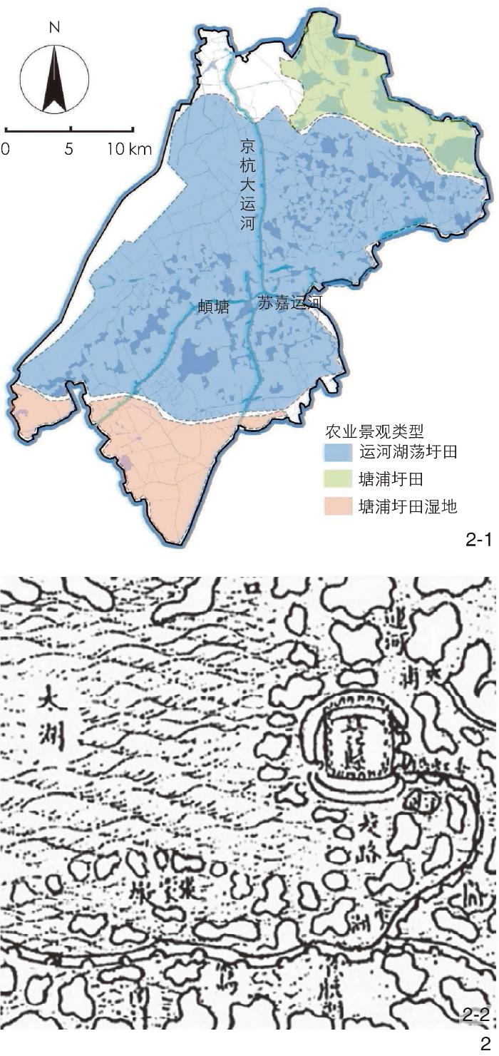
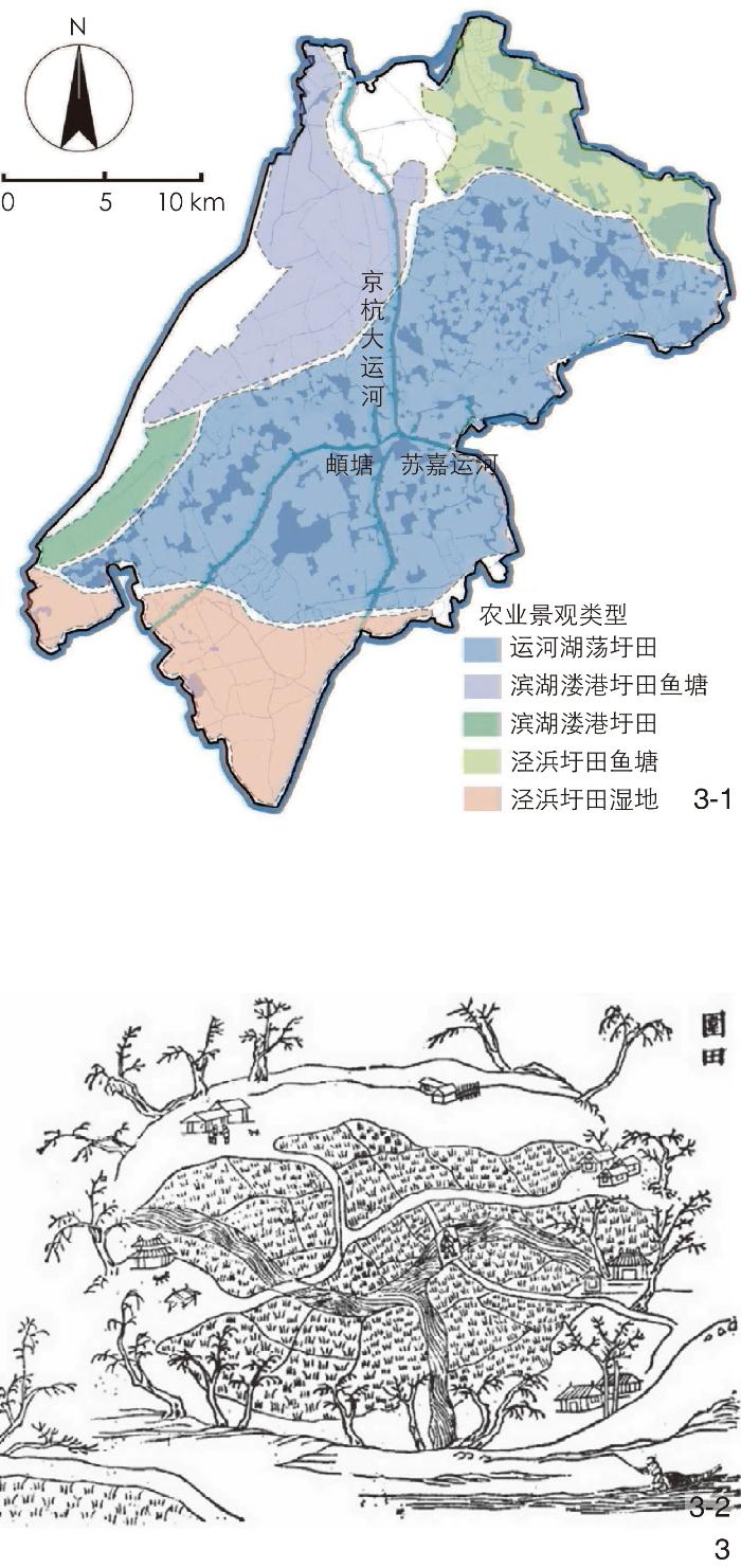
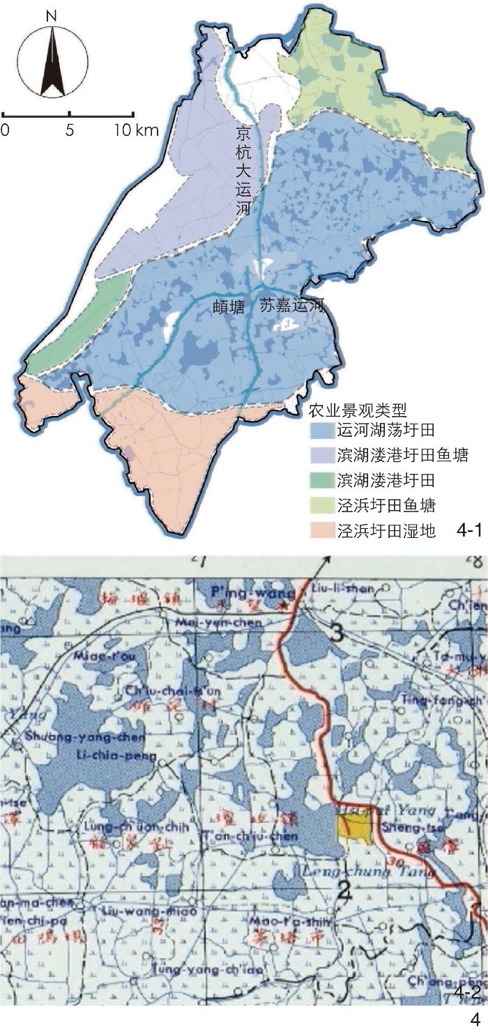
以具有代表性的江苏省苏州市吴江区为例,运用ArcGIS空间分析与历史舆图回溯等方法,分析江南运河流域吴江段不同历史时期的农业景观格局演变。
总结提炼了运河流域农业景观的互构性、延续性、层次性特征;发现运河水系主导、产业变迁、城镇化割裂、水利建设等是影响农业景观变迁的主要驱动因素。
江南运河流域吴江段农业景观变迁体现了生产、生活、生态相互适应,地景、文化、经济相互融合的乡土农耕景观构筑智慧。农业景观变迁特征的提取为保护传承乡土景观提供了方向指引,而驱动机制的梳理可以找到协调城乡融合发展的关键影响要素,未来研究可在驱动因素的分类与量化分析方面补充更多农业景观地域类型的案例,为城乡融合高质量发展,乡村振兴下的农业景观保护传承和适宜性规划提供更多理论支撑与科学路径。
张琳 , 苗晏凯 , 黄松 . 江南运河流域吴江段农业景观演变特征及驱动机制[J]. 风景园林, 2024 , 31(12) : 49 -56 . DOI: 10.3724/j.fjyl.202402090090
The agricultural landscape within the canal basin represents a fusion of natural and cultural elements shaped by centuries of agricultural activity. With significant social, cultural, and environmental values, such agricultural landscape has contributed to sustainable agricultural production, water management, and cultural heritage preservation. The Jiangnan water network area has long been one of China’s most prosperous areas. Its unique resources, shaped by historical development, have given rise to valuable examples of agricultural heritage. Over thousands of years, continuous development in this area has fostered a distinctive local landscape, notably the polder field characteristic of canal basins. Jiangnan’s agricultural development stands as one of the most distinctive agricultural development paradigms in China. However, rapid urbanization has led to increased heterogeneity, disorder, and passivity in local agricultural landscape, threatening the unique patterns of pond field and water town emblematic of the Jiangnan Canal Basin. Understanding how urbanization has influenced these landscape changes and analyzing underlying driving mechanisms are crucial for preserving local heritage while promoting balanced urban-rural integration.
Taking Wujiang District in Suzhou, a representative area with the aforesaid agricultural landscape, as an example, this research employs ArcGIS spatial analysis to process and analyze remote sensing images of the area. Local land use is categorized into three main types: Town (impermeable surfaces), farmland (arable land), and water system (water body, ice, and wetland). By comparing land use classification maps from different periods, the research reviews land use transitions among towns, water systems, and farmlands, highlighting the evolution characteristics of agricultural landscape in Wujiang Section of Jiangnan Canal Basin across historical stages. Historical maps and data are also utilized to analyze the spatial patterns of agricultural landscape and land partitioning in Wujiang District. This approach aids in revealing the temporal dynamics and underlying mechanisms driving landscape changes over time.
The analysis reveals that the transformation of the agricultural landscape in the Wujiang Section of Jiangnan Canal Basin is concentrated around four major canals and their tributary water systems. Over time, these elements have evolved into an interdependent cultural and ecological landscape system, comprising towns, water systems, and farmlands. In the process of urbanization, natural disasters, industrial upgrades, and land management efforts, the agricultural landscape in Wujiang has been continuously integrated and optimized. This process has not only fostered the development of a traditional regional trade economy but also given rise to a distinctive agricultural heritage that reflects the unique characteristics of Jiangnan culture. The agricultural landscape in the Wujiang Section of Jiangnan Canal Basin embodies the interaction between human, water, and field, which has shaped distinctive production and living modes in local area. This dynamic relationship shows the interconnection, continuity, and hierarcy of such landscape, demonstrating how it adapts to local environment under the “people − water − field” system.
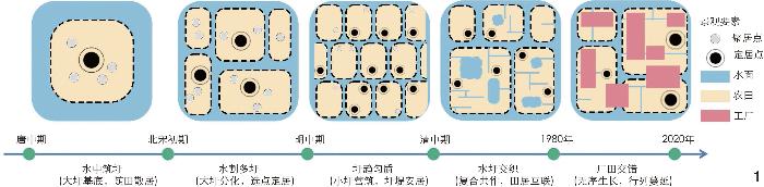
This research focuses on the agricultural landscape in the Wujiang Section of Jiangnan Canal Basin, utilizing ArcGIS and historical imagery as the primary tools of analysis, supplemented by typological cluster analysis and other methods. The research refines and reveals the characteristics of “people − water − field” interactions embodied by the agricultural landscape in the Wujiang Section of Jiangnan Canal Basin, particularly under the influence of urbanization. Based on this analysis, the research identifies the interactive mechanisms driving changes in landscape elements. The key findings are as follows: The transformation of the agricultural landscape in the Wujiang Section of Jiangnan Canal Basin can be divided into five stages — constructing polders in water (large polder bases interspersed with scattered fields), subdividing polders (differentiation of large polders with settlement clusters), unifying polders (small-scale polder construction with stable embankments), interweaving water and polders (composite cooperation with interconnected fields and residences), and interweaving factories and fields (disorderly expansion in rows and columns). These stages demonstrate that landscape evolution in Wujiang is characterized by inter-construction, continuous adaptation, and hierarchy. Canal dominance, industrial transformation, rapid urbanization, and water conservancy projects are identified as the primary drivers of landscape change, reflecting the interaction between natural water system, urban development, and agricultural land. The research clarifies how these elements adapt to one another in local changing environment. By reviewing the types and structures of agricultural landscape shaped by varying canal morphologies in Wujiang District, the research highlights the relationship between urbanization’s impact and the characteristics of landscape change in the basin. Future research may extend this analysis to include additional agricultural landscape types and conduct more detailed quantitative assessments of driving factors. The findings aim to offer theoretical support and scientific guidance for preserving, inheriting, and planning agricultural landscape under the framework of high-quality urban-rural integration and rural revitalization. Ultimately, the research seeks to explore the relationship between regional canal changes and their influence on agricultural landscape elements, as well as the underlying causes.
图5 “水圩交织”阶段农业景观类型特征5-1 吴江研究范围内水圩交织阶段农业景观类型分区 Fig. 5 Type characteristics of agricultural landscape changes during the ‘water polder intertwining’ phase 5-1 Zoning of agricultural landscape typesduring the stage of water – polder intertwining in the research area in Wujiang District |
文中图片均由作者绘制,其中
| [1] |
中共中央国务院.中共中央国务院关于学习运用“千村示范、万村整治”工程经验有力有效推进乡村全面振兴的意见[EB/OL].(2024-01-01)[2024-09-27]. https://www.gov.cn/zhengce/202402/content_6929935.htm.
State Council of the CPC Central Committee. Opinions of the CPC Central Committee and State Council on Learning and Applying the Experience of the “Thousand Villages Demonstration and Ten Thousand Villages Improvement” Project to Powerfully and Effectively Promote the Comprehensive Revitalization of Rural Areas[EB/OL]. (2024-01-01)[2024-09-27]. https://www.gov.cn/zhengce/202402/content_6929935.htm.
|
| [2] |
伽红凯, 卢勇, 陈晖. 环境适应与技术选择: 明清以来长三角地区特色农业发展研究[J]. 中国农史, 2021, 40 (4): 127-139
GA H K, LU Y, CHEN H. Environmental Adaptation and Technology Selection: Research on the Development of Characteristic Agriculture in the Yangtze River Delta Region since Ming and Qing Dynasties[J]. Agricultural History of China, 2021, 40 (4): 127-139.
|
| [3] |
侯晓蕾, 郭巍. 圩田景观研究: 形态、功能及影响探讨[J]. 风景园林, 2015, 119 (6): 123-128
HOU X L, GUO W. Polder Landscape Study: Discussion on Form, Function and Impact[J]. Landscape Architecture, 2015, 119 (6): 123-128.
|
| [4] |
王艺彭.结构语言学视角下的江南乡土景观语言解读与现代适应[D].杭州: 浙江大学, 2022.
WANG Y P. Interpretation and Modern Adaptation of Jiangnan Vernacular Landscape Language Under the Perspective of Structural Linguistics[D]. Hangzhou: Zhejiang University, 2022.
|
| [5] |
袁源, 张小林, 李红波, 等. 基于位置大数据的村域尺度多功能性评价: 以苏州市为例[J]. 自然资源学报, 2021, 36 (3): 674-687
YUAN Y, ZHANG X L, LI H B, et al. Evaluation of Village Scale Multifunctionality Based on Location Big Data: Taking Suzhou as an Example[J]. Journal of Natural Resources, 2021, 36 (3): 674-687
|
| [6] |
RADER R, BIRKHOFER K, SCHMUCKI R, et al. Organic Farming and Heterogeneous Landscapes Positively Affect Different Measures of Plant Diversity[J]. Journal of Applied Ecology, 2014, 51 (6): 1544-1553
|
| [7] |
MÜCHER C A, KLIJN J A, WASCHER D M, et al. A New European Landscape Classification (LANMAP): A Transparent, Flexible and User-Oriented Methodology to Distinguish Landscapes[J]. Ecological Indicators, 2010, 10 (1): 87-103
|
| [8] |
GHOOMI H, YAZDANFAR S A A, HOSSEINI S, et al. Comparing the Components of Sense of Place in the Traditional and Modern Residential Neighborhoods[J]. Procedia: Social and Behavioral Sciences, 2015, 201: 275-285
|
| [9] |
GARCÍAM, GILBERT J D, PARRA G, et al. Wetlands Classification for Amphibian Conservation in Mediterranean Landscapes[J]. Biodiversity and Conservation, 2010, 19 (3): 901-911
|
| [10] |
ZHU P, ZHUANG Q, EVA J, et al. Importance of Biophysical Effects on Climate Warming Mitigation Potential of Biofuel Crops over the Conterminous United States[J]. GCB Bioenergy, 2017, 9 (3): 577-590
|
| [11] |
TEMES-CORDOVEZ R, MOYA FUERO A. Dynamics of Change in the Peri-Urban Landscape of Huerta de Valencia: The Case of La Punta (Valencia)[C]//MIRALLES I GARCIA J L, BREBBIA C A. Ecosystems and Sustainable Development X. Ashurst: WIT Press, 2015: 123-131.
|
| [12] |
SABR A, MOEINADDINI M, AZARNIVAND H, et al. Assessment of Land Use and Land Cover Change Using Spatiotemporal Analysis of Landscape: Case Study in South of Tehran[J]. Environmental Monitoring and Assessment, 2016, 188 (12): 691.
|
| [13] |
谢雨婷, 应佳欣, 陈琳. 长江三角洲圩田景观的类型、形态生成与适应性转型[J]. 城市发展研究, 2022, 29 (4): 70-77
XIE Y T, YING J X, CHEN L. Typology, Morphogenesis and Adaptive Transformation of Polder Landscape in the Yangtze River Delta[J]. Urban Development Studies, 2022, 29 (4): 70-77
|
| [14] |
谢雨婷, 诺尔夫, 范诺贝克. 长江三角洲水管理与空间规划的整合: 历史回顾与展望[J]. 风景园林, 2022, 29 (2): 39-45
XIE Y T, NOLF C, VANNEUBECK F. Towards Integrated Water Management and Spatial Planning: Historica Review and Prospects for the Yangtze River Delta[J]. Landscape Architecture, 2022, 29 (2): 39-45.
|
| [15] |
王建革, 周晴. 宋元时期江南运河对嘉湖平原圩田体系的影响[J]. 风景园林, 2019, 26 (12): 21-27
WANG J G, ZHOU Q. Influence of Jiangnan Canal on Jiaxing and Huzhou Plain’s Polder System in Song and Yuan Dynasties[J]. Landscape Architecture, 2019, 26 (12): 21-27.
|
| [16] |
姜雪琳.以圩田开垦为主体的太湖流域农业景观研究[D].北京: 北京林业大学, 2019.
JIANG X L. Focusing on the Polder Reclamation: Research on the Agricultural Landscape of Taihu Basin[D]. Beijing: Beijing Forestry University, 2019.
|
| [17] |
刘通, 王向荣. 以农业景观为主体的太湖流域水网平原区域景观研究[J]. 风景园林, 2015, 22 (8): 23-28
LIU T, WANG X R. Focusing on Agricultural Landscape: Study on the Regional Landscape of River Network Plain in Taihu Basin[J]. Landscape Architecture, 2015, 22 (8): 23-28.
|
| [18] |
李畅. 从乡居到乡愁: 文化人类学视野下中国乡土景观的认知概述[J]. 中国园林, 2016, 32 (9): 29-32
LI C. From Native Dwelling to Nostalgia: From Residence to Nostalgia: A Literature Review on Chinese Vernacular Landscape Cognition from the Aspect of Cultural Anthropology[J]. Chinese Landscape Architecture, 2016, 32 (9): 29-32.
|
| [19] |
王建革. 19—20世纪江南田野景观变迁与文化生态[J]. 民俗研究, 2018, 138 (2): 34-47
WANG J G. Field Landscape Changes and Cultural Ecology of Jiangnanin the 19th and 20th Centuries[J]. Folklore Studies, 2018, 138 (2): 34-47
|
| [20] |
吴必虎, 徐小波. 传统村落与旅游活化: 学理与法理分析[J]. 扬州大学学报(人文社会科学版), 2017, 21 (1): 5-21
WU B H, XU X B. Tourism Oriented Rejuvenation of Chinese Traditional Villages: An Explorative Research[J]. Journal of Yangzhou University (Humanities and Social Sciences), 2017, 21 (1): 5-21.
|
| [21] |
沈卫新.嘉靖吴江县志[M].扬州: 广陵书社, 2013: 390.
SHEN W X. Chronicles of Wujiang County During Jiajing Period[M]. Yangzhou: Guangling Publishing House, 2013: 390.
|
| [22] |
江娟丽, 杨庆媛, 张忠训, 等. 农业景观研究进展与展望[J]. 经济地理, 2021, 41 (6): 223-231
JIANG J L, YANG Q Y, ZHANG Z X, et al. Progress and Prospect of Agricultural Landscape Research[J]. Economic Geography, 2021, 41 (6): 223-231.
|
| [23] |
吴江市档案局.道光吴江县志汇编[M].扬州: 广陵书社, 2010.
Wujiang City Archives Bureau. Compilation of Chronicles of Wujiang County During Daoguang Period[M]. Yangzhou: Guangling Publishing House, 2010.
|
| [24] |
黄宣伟.太湖流域规划与综合治理[M].北京: 中国水利水电出版社, 2000: 25-29.
HUANG X W. Planning and Comprehensive Management of Taihu Lake Basin[M]. Beijing: China Water & Power Press, 2000: 25-29.
|
| [25] |
吴浩云, 陆志华. 太湖流域治水实践回顾与思考[J]. 水利学报, 2021, 52 (3): 277-290
WU H Y, LU Z H. Review and Thinking of Water Management Practice in Taihu Basin[J]. Journal of Hydraulic Engineering, 2021, 52 (3): 277-290.
|
| [26] |
王建革.江南环境史研究[M].上海: 科学出版社, 2016: 173-181.
WANG J G. Research on the Environmental History of Jiangnan[M]. Shanghai: Science Press, 2016: 173-181.
|
| [27] |
谢湜.高乡与低乡: 11—16世纪江南历史地理研究[M].北京: 生活·读书·新知三联书店, 2015: 71.
XIE S. High Countryside and Low Countryside: A Study of the Historical Geography of Jiangnan from the 11th to the 16th Century[M]. Beijing: SDX Joint Publishing Company, 2015: 71.
|
| [28] |
雷诚, 孙萌忆, 丁邹洲, 等. 产镇融合演化路径及规划策略探讨: 江苏省小城镇发展40年[J]. 城市规划学刊, 2020 (1): 93-101
LEI C, SUN M Y, DING Z Z, et al. Evolution and a Planning Model of Town-Industry Integration: The Four Decades of Small Town Development in Jiangsu Province[J]. Urban Planning Forum, 2020 (1): 93-101.
|
| [29] |
谢雨婷, 诺尔夫. 长三角大都市区文化景观特征评估[J]. 中国园林, 2020, 36 (12): 73-78
XIE Y T, NOLF C. Cultural Landscape Characterization in the Metropolitan Areas of the Yangtze River Delta[J]. Chinese Landscape Architecture, 2020, 36 (12): 73-78.
|
/
| 〈 |
|
〉 |