
上海市中心城区绿地生态网络演化多情景模拟及景观连接度评价
|
刘杰/女/博士/上海市园林科学规划研究院工程师/研究方向为城市绿地生态网络发展模拟 |
|
胡国华/男/博士/华东师范大学地理科学学院副教授/研究方向为城市土地利用变化建模与可持续发展 |
|
张浪/男/博士/上海市园林科学规划研究院院长、教授级高工(二级)/城市困难立地园林绿化国家创新联盟理事长/上海城市困难立地绿化工程技术研究中心主任/城市困难立地生态园林国家林草局重点实验室主任/本刊编委/研究方向为生态园林规划设计与技术研究 |
Copy editor: 边紫琳
收稿日期: 2024-01-23
修回日期: 2024-09-14
网络出版日期: 2025-12-16
基金资助
国家自然科学基金面上项目“城市生态廊道多尺度结构与功能连接度的关联机制”(32171569)
国家重点研发计划课题“典型城市廊道多功能耦合网络构建与生态修复技术”(2022YFC3802604)
国家自然科学基金青年项目“SSPs框架下的土地利用变化模拟模型及其在长江经济带生态评估中的应用”(41901322)
上海市科委“科技创新行动计划”社会发展科技攻关项目“超大城市上海公园城市构建关键技术研究与示范”(23DZ1204400)
版权
Multi-scenario Simulation and Landscape Connectivity Evaluation of the Evolution of Green Space Ecological Network in Central Urban Area of Shanghai
|
LIU Jie, Ph.D., is an engineer in Shanghai Academy of Landscape Architecture Science and Planning. Her research focuses on development simulation of urban green space ecological network |
|
HU Guohua, Ph.D., is an associate professor in the School of Geographic Sciences, East China Normal University. His research focuses on urban land use change modeling and sustainable development |
|
ZHANG Lang, Ph.D., is president of and a professorate senior engineer (Grade II) in Shanghai Academy of Landscape Architecture Science and Planning, chairman of the National Innovation Alliance of National Forestry and Grassland Administration on Afforestation and Landscaping of Challenging Urban Sties, the director of Shanghai Engineering Research Center of Challenging Urban Sites, director of the Key Laboratory of National Forestry and Grassland Administration for Ecological Landscaping of Challenging Urban Sites, and an editorial board member of this journal. His research focuses on planning, design and technology of ecological landscape |
Received date: 2024-01-23
Revised date: 2024-09-14
Online published: 2025-12-16
Copyright
通过对上海市中心城区未来用地进行多情景模拟,测度不同情景下绿地生态网络景观连接度变化,为未来城市生态空间优化提供依据。
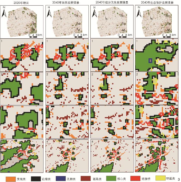
基于斑块生成土地利用变化模拟(patch-generating land use simulation, PLUS)模型,对上海市中心城区绿地生态网络演化进行多情景模拟,并通过形态学空间格局分析(morphological spatial pattern analysis, MSPA)与景观连接度分析,探究未来不同情景下城市绿地生态网络结构性连接和功能性连接的差异。
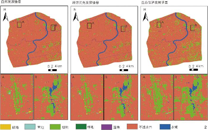
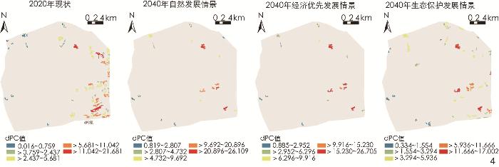
1)未来上海市中心城区不同情景下绿地面积均有不同幅度的减少,但在生态保护发展情景下,绿地面积的衰减速度得到有效控制;2)就结构性连接而言,生态保护发展情景下的绿地生态网络具有较好的廊道连通性,能够有效促进物种扩散和能量流动;3)就功能性连接而言,绿地生态网络重要斑块在多情景模拟中的空间分布基本一致,且斑块重要性指数(delta probability of connectivity, dPC)分布可为未来重要潜在源地斑块的统筹规划提供指导。
生态保护发展情景可较好维持生态网络的连接度以及景观结构的稳定性,在未来的城市建设中,可通过政策调控及规划促进城市生态空间、城市绿地生态网络健康发展。
刘杰 , 胡国华 , 张浪 . 上海市中心城区绿地生态网络演化多情景模拟及景观连接度评价[J]. 风景园林, 2024 , 31(11) : 70 -78 . DOI: 10.3724/j.fjyl.202401230056
With urban development and land use expansion, the structure and layout of various land use types are in dynamic change, and the fragmentation of ecological space becomes an important problem faced in the process of urbanization. The development of complex urban systems is highly influenced by social factors and human interference, and simple extrapolation and prediction of empirical knowledge can hardly predict future changes in urban land use. In view of this, it is recommended to use future land use simulation technology to simulate the changes of urban green space ecological network driven by multiple factors, so as to produce more reliable simulation results, thus improving the foresight and scientificity of urban planning work. Taking the central urban area of Shanghai as an example, this research conducts multi-scenario simulations of future land use, and measures the connectivity of green space ecological network under different scenarios, so as to provide a basis for optimizing urban ecological space in the future.
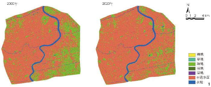
The current land use data spanning the period from 2000 to 2020 are used as the base data, and raster data obtained are derived from 30 m×30 m rasters. Driving factors are screened, including population density, GDP distribution, distance to railroads, highways, and main roads, average annual climate/precipitation, etc., and the suitability probability of each type of land use is calculated. Taking 2000 as the base year, the land use scenario for the target year 2020 is simulated based on the PLUS model, and the spatial consistency between this simulation scenario and the actual status of land use in 2020 is compared in combination with the kappa coefficient and the overall accuracy. On the basis of satisfying the simulation accuracy, the land use changes in 2040 under different constraints are simulated, and the urban green space ecological network under multiple scenarios of future urban development is extracted. In addition, morphological spatial pattern analysis (MSPA) and functional connectivity measurement index analysis are implemented to explore the differences in structural connectivity and functional connectivity of urban green space ecological network under different scenarios in the future.
1) During the period from 2000 to 2020, within the central urban area of Shanghai, the area of green space decreases most significantly, indicating that the rapid urbanization process has disturbed the city’s green ecological network to a great extent. In 2040, the area of green space will decrease to different extents under the three land use simulation scenarios, with the decay rate of green space under the ecological conservation and development scenario being effectively controlled. 2) The ecological conservation and development scenario provides good protection for the ecological sources of green space, and the overall patch fragmentation is mitigated, with the area of its bridging and traffic circle categories being significantly higher than that of the natural development scenario and the economic priority development scenario, which indicates that under the ecological conservation and development scenario, the ecological network of the green space has a stronger corridor connectivity, and is able to effectively improve the diffusion of species and the flow of energy between the ecological sources. 3) Under the multiple simulation scenarios targeting 2040, the spatial distribution and importance of key patches under different development scenarios of green space ecological network are basically the same, and such patches typically have a better ecological substrate, so they should be especially protected in future urban development; the patches with higher delta probability of connectivity (dPC) indicate that they are more important for future connectivity of green space ecological network, but they may have poor connectivity at present, so they can be used as potential source patches of green space ecological network for integrated planning.
Compared to other scenarios, the decay rate of green space under the ecological conservation and development scenario targeting 2040 has been effectively controlled. In terms of structural connectivity (physical linkage), the green space ecological network has great corridor connectivity and stable network structure under the ecological conservation and development scenario. In terms of functional connectivity, important patches are crucial to the structural stability and socio-ecological functioning of the ecological network. Considering that the coordinated development of the economy and ecology is a long-term process, there is a long way to go to maintain the long-term ecological health of urban centers through policy regulation and planning guidance. In future urban construction, policy regulation and planning can guide the optimization of urban ecological space and maintain the healthy development of urban green space ecological network.
表1 土地利用模拟主要数据类别、格式及来源Tab. 1 Main data categories, formats, and sources for land use simulation |
| 数据类别 | 数据格式 | 精度 | 数据来源 | |
| 基础数据 | 2000、2020年上海市中心城区地表覆盖类型 | 栅格数据 | 30 m×30 m | 地球大数据科学数据中心数据共享 服务系统(data.casearth.cn) |
| 驱动因子数据 | 人口密度 | 栅格数据 | 1 km×1 km | 资源环境科学数据平台 (www.resdc.cn) |
| GDP分布 | ||||
| 到铁路、高速公路、主干道的距离 | 矢量数据 (shapefile) | — | OpenStreeMap (www.openstreetmap.org) | |
| 年平均气温 | 栅格数据 | 1 km×1 km | 资源环境科学数据平台 (www.resdc.cn) | |
| 平均年降水量 | ||||
| 高程 | 栅格数据 | 30 m×30 m | 地理空间数据云(www.gscloud.cn) | |
表2 研究区域未来土地利用发展情景的条件设置Tab. 2 Setting of future land use development scenarios for the research area |
| 发展情景 | 条件设置 |
| 自然发展情景 | 用地模拟遵循上海市中心城区2000—2020年的土地利用演化规律,不考虑其他约束条件,模拟时不对各类土地利用类型的转化规则做任何限制 |
| 经济优先发展情景 | 综合考虑2000—2020年上海市中心城区GDP增长率与各土地利用类型之间的关系,以自然发展情景为参考,模拟时设置不透水面发展幅度增加15%,绿地、草地衰减幅度增加25%,耕地基本不参与土地利用转化 |
| 生态保护发展情景 | 参考“上海2035”中对于各用地类型占比的规划,以自然发展情景为参考,模拟时设置耕地、草地发展幅度降低20%,不透水面发展幅度降低20%,耕地、水域基本不参与土地利用转化 |
| 形态分类 | 生态学含义 |
| 支线类 | 只有一端与边缘类、桥接类、环道类或者孔隙类相连的绿地像元集合 |
| 边缘类 | 核心类和主要非绿地区域之间的过渡区域 |
| 孔隙类 | 核心类和非绿地斑块之间的过渡区域,即内部斑块边缘(边缘效应) |
| 孤岛类 | 彼此不相连的小斑块,内部物质、能量交流和传递的可能性比较小,但对于生态网络的整体构建具有重要作用 |
| 核心类 | 前景像元中较大的绿地斑块,通常为生态源地,有助于生物多样性保护 |
| 桥接类 | 连接核心类的具有狭长廊道特征的绿地像元,是生态网络中斑块连接的廊道,对物种迁移及结构连接度具有重要意义 |
| 环道类 | 连接同一核心类的狭长廊道(绿地像元),是同一核心区内物种迁移的捷径,可以增强能量流通 |
表4 研究区域各土地利用类型在PLUS模型中的模拟精度Tab. 4 Simulation accuracy of various land use types in the research area as indicated in the PLUS |
| 土地利用类型 | 模拟精度 | |
| 制图精度 | 用户精度 | |
| 耕地 | 0.97 | 0.93 |
| 草地 | 0.92 | 0.96 |
| 绿地 | 0.88 | 0.89 |
| 林地 | 0.83 | 0.79 |
| 湿地 | 0.89 | 0.89 |
| 不透水面 | 0.98 | 0.98 |
| 水域 | 0.96 | 0.95 |
表5 研究区域现状及模拟情景各土地利用类型面积Tab. 5 Current area and simulated area of each land use type in the research area |
| 土地利用类型 | 2000年现状面积 | 2020年现状面积 | 2040年模拟情景面积 | ||
| 自然发展情景 | 经济优先发展情景 | 生态保护发展情景 | |||
| 耕地 | 25.38 | 43.47 | 43.74 | 43.20 | 43.83 |
| 草地 | 123.93 | 164.79 | 190.62 | 174.60 | 187.11 |
| 绿地 | 15 720.30 | 8 948.25 | 5 912.37 | 5 151.51 | 7 270.47 |
| 林地 | 67.23 | 55.62 | 25.02 | 19.71 | 34.02 |
| 湿地 | 422.64 | 544.95 | 553.50 | 537.39 | 553.05 |
| 不透水面 | 47 069.46 | 53 893.80 | 57 131.19 | 57 960.72 | 55 717.02 |
| 水域 | 2 527.65 | 2 305.71 | 2 100.15 | 2 069.46 | 2 151.09 |
表6 研究区域多情景城市绿地生态网络面积变化统计Tab. 6 Statistics on area changes of urban green space ecological network under multiple scenarios in the research area |
| 形态分类 | 2020年现状 面积/hm2 | 2040年自然发展情景 | 2040年经济优先发展情景 | 2040年生态保护发展情景 | |||||
| 面积变化/hm2 | 变化百分比/% | 面积变化/hm2 | 变化百分比/% | 面积变化/hm2 | 变化百分比/% | ||||
| 支线类 | 1 071.99 | −264.06 | −24.63 | −383.22 | −35.75 | −31.81 | −2.97 | ||
| 边缘类 | 2 071.80 | −988.56 | −47.72 | −1 035.09 | −49.96 | −829.36 | −40.03 | ||
| 孔隙类 | 47.88 | −31.68 | −66.17 | −27.36 | −57.14 | 6.21 | 12.97 | ||
| 孤岛类 | 2 048.94 | 305.01 | 14.89 | −99.27 | −4.84 | −514.55 | −25.11 | ||
| 核心类 | 2 835.36 | −1 721.52 | −60.72 | −1 784.97 | −62.95 | −393.48 | −13.88 | ||
| 桥接类 | 622.17 | −295.29 | −47.46 | −363.06 | −58.35 | −1.55 | −0.25 | ||
| 环道类 | 305.73 | −70.38 | −23.02 | −139.68 | −45.69 | 65.16 | 21.31 | ||
表7 多情景城市绿地生态网络功能连接度统计Tab. 7 Statistics on functional connectivity of green space ecological network under multiple scenarios |
| 指标 | 2020年现状 | 2040年模拟情景 | ||
| 自然发展情景 | 经济优先发展情景 | 生态保护发展情景 | ||
| 注:PCnum为Conefor软件计算所得结果,指可能连通性总指数值。 | ||||
| F | 698.257 500 0 | 28.758 090 0 | 26.385 710 0 | 210.936 300 0 |
| AWF | 67.639 750 0 | 1.859 992 0 | 1.695 517 0 | 14.839 300 0 |
| PCnum | 168.888 700 0 | 4.607 686 0 | 4.205 458 0 | 34.769 830 0 |
| EC(PC) | 12.995 720 0 | 2.146 552 0 | 2.050 721 0 | 5.896 594 0 |
文中图表均由作者绘制,其中上海市中心城区边界信息来源于标准地图服务网站,审图号:沪S(2022)016号。
| [1] |
孙毅中, 杨静, 宋书颖, 等. 多层次矢量元胞自动机建模及土地利用变化模拟[J]. 地理学报, 2020, 75 (10): 2164-2179
SUN Y Z, YANG J, SONG S Y, et al. Modeling of Multilevel Vector Cellular Automata and Its Simulation of Land Use Change[J]. Acta Geographica Sinica, 2020, 75 (10): 2164-2179
|
| [2] |
王如松, 欧阳志云. 社会-经济-自然复合生态系统与可持续发展[J]. 中国科学院院刊, 2012, 27 (3): 337-345
WANG R S, OUYANG Z Y. Social-Economic-Natural Complex Ecosystem and Sustainability[J]. Chinese Academy of Sciences, 2012, 27 (3): 337-345.
|
| [3] |
ZHANG Y, CHANG X, LIU Y, et al. Urban Expansion Simulation Under Constraint of Multiple Ecosystem Services (MESs) Based on Cellular Automata (CA)-Markov Model: Scenario Analysis and Policy Implications[J]. Land Use Policy, 2021, 108: 105667.
|
| [4] |
孔繁花, 尹海伟. 济南城市绿地生态网络构建[J]. 生态学报, 2008, 28 (4): 1711-1719
KONG F H, YIN H W. Developing Green Space Ecological Networks in Jinan City[J]. Acta Ecologica Sinica, 2008, 28 (4): 1711-1719
|
| [5] |
SHEN Z, WU W, TIAN S, et al. A Multi-scale Analysis Framework of Different Methods Used in Establishing Ecological Networks[J]. Landscape and Urban Planning, 2022, 228: 104579.
|
| [6] |
申佳可, 王云才. 景观生态网络规划: 由空间结构优先转向生态系统服务提升的生态空间体系构建[J]. 风景园林, 2020, 27 (10): 37-42
SHEN J K, WANG Y C. Landscape Ecological Network Planning: Ecological Spaces System Building from Spatial Structural Priority to Ecosystem Services Improvement[J]. Landscape Architecture, 2020, 27 (10): 37-42.
|
| [7] |
LIANG X, GUAN Q, CLARKE K C, et al. Understanding the Drivers of Sustainable Land Expansion Using a Patch-Generating Land Use Simulation (PLUS) Model: A Case Study in Wuhan, China[J]. Computers, Environment and Urban Systems, 2021, 85: 101569.
|
| [8] |
黎夏, 叶嘉安, 刘小平. 地理模拟系统在城市规划中的应用[J]. 城市规划, 2006, 30 (6): 69-74
LI X, YE J A, LIU X P. Geographical Simulation System for Urban Planning[J]. City Planning Review, 2006, 30 (6): 69-74
|
| [9] |
李少英, 刘小平, 黎夏, 等. 土地利用变化模拟模型及应用研究进展[J]. 遥感学报, 2017, 21 (3): 329-340
LI S Y, LIU X P, LI X. Simulation Model of Land Use Dynamics and Application: Progress and Prospects[J]. Journal of Remote Sensing, 2017, 21 (3): 329-340.
|
| [10] |
唐华俊, 吴文斌, 杨鹏, 等. 土地利用/土地覆被变化(LUCC)模型研究进展[J]. 地理学报, 2009, 64 (4): 456-468
TANG H J, WU W B, YANG P, et al. Recent Progresses of Land Use and Land Cover Change (LUCC) Models[J]. Acta Geographica Sinica, 2009, 64 (4): 456-468
|
| [11] |
李秀彬. 全球环境变化研究的核心领域: 土地利用/土地覆被变化的国际研究动向[J]. 地理学报, 1996, 54 (6): 553-558
LI X B. A Review of the International Research on Land Use/Land Cover Change[J]. Acta Geographica Sinica, 1996, 54 (6): 553-558.
|
| [12] |
邬建国. 景观生态学中的十大研究论题[J]. 生态学报, 2004, 24 (9): 2074-2076
WU J G. The Key Research Topics in Landscape Ecologys[J]. Acta Ecologica Sinica, 2004, 24 (9): 2074-2076.
|
| [13] |
WU J, HOBBS R. Key Issues and Research Priorities in Landscape Ecology: An Idiosyncratic Synthesis[J]. Landscape Ecology, 2002, 17 (4): 355-365
|
| [14] |
路云阁, 蔡运龙, 许月卿. 走向土地变化科学: 土地利用/覆被变化研究的新进展[J]. 中国土地科学, 2006 (1): 55-61
LU Y G, CAI Y L, XU Y Q, et al. Towards Land Change Science: The Progress of LUCC[J]. China Land Science, 2006 (1): 55-61.
|
| [15] |
吴文斌, 杨鹏, 柴崎亮介, 等. 基于Agent的土地利用/土地覆盖变化模型的研究进展[J]. 地理科学, 2007 (4): 573-578
WU W B, YANG P, SHIBASAKI R, et al. Agent-Based Model for Land-Use/Cover Change: A Review[J]. Scientia Geographica Sinica, 2007 (4): 573-578.
|
| [16] |
匡文慧, 刘纪远, 邵全琴, 等. 区域尺度城市增长时空动态模型及其应用[J]. 地理学报, 2011, 66 (2): 178-188
KUANG W H, LI J Y, SHAO Q Q, et al. Dynamic Urban Growth Model at Regional Scale and Its Application[J]. Acta Geographica Sinica, 2011, 66 (2): 178-188
|
| [17] |
贾梦圆, 陈天. 基于土地利用变化模拟的水生态安全格局优化方法: 以天津市为例[J]. 风景园林, 2021, 28 (3): 95-100
JIA M Y, CHEN T. Identifying and Optimizing Hydro-ecological Security Pattern with Land Use Change Modeling: A Case Study of Tianjin[J]. Landscape Architecture, 2021, 28 (3): 95-100.
|
| [18] |
LIU X, HU G, AI B, et al. Simulating Urban Dynamics in China Using a Gradient Cellular Automata Model Based on S-Shaped Curve Evolution Characteristics[J]. International Journal of Geographical Information Science, 2018, 32 (1): 73-101
|
| [19] |
石晶, 石培基, 王梓洋, 等. 基于PLUS-InVEST模型的酒泉市生态系统碳储量时空演变与预测[J]. 环境科学, 2024, 45 (1): 300-313
SHI J, SHI P J, WANG Z Y, et al. Spatial-Temporal Evolution and Prediction of Carbon Storage in Jiuquan City Ecosystem Based on PLUS-InVEST Model[J]. Environmental Science, 2024, 45 (1): 300-313.
|
| [20] |
巩晟萱, 张玉虎, 李宇航. 基于PLUS-InVEST模型的京津冀碳储量变化及预测[J]. 干旱区资源与环境, 2023, 37 (6): 20-28
GONG S X, ZHANG Y H, LI Y H. Spatio-temporal Variation and Prediction of Carbon Storage in Beijing-Tianjin-Hebei Region: A PLUS-InVEST Model Approach[J]. Journal of Arid Land Resources and Environment, 2023, 37 (6): 20-28.
|
| [21] |
吴昌广, 周志翔, 王鹏程, 等. 景观连接度的概念、度量及其应用[J]. 生态学报, 2010, 30 (7): 1903-1910
WU C G, ZHOU Z X, WANG P C, et al. The Concept and Measurement of Landscape Connectivity and Its Application[J]. Acta Ecologica Sinica, 2010, 30 (7): 1903-1910.
|
| [22] |
陈春娣, 贾振毅, 吴胜军, 等. 基于文献计量法的中国景观连接度应用研究进展[J]. 生态学报, 2017, 37 (10): 3243-3255
CHEN C D, JIA Z Y, WU S J, et al. A Bibliometric Review of Chinese Studies on the Application of Landscape Connectivity[J]. Acta Ecologica Sinica, 2017, 37 (10): 3243-3255.
|
| [23] |
张晨笛, 刘杰, 张浪, 等. 基于城市生态廊道概念应用的三个衍生概念生成与辨析[J]. 中国园林, 2021, 37 (11): 109-114
ZHANG C D, LIU J, ZHANG L, et al. Generation and Analysis of Three Derived Concepts Based on the Application of Urban Ecological Corridor Concept[J]. Chinese Landscape Architecture, 2021, 37 (11): 109-114.
|
| [24] |
陈利顶, 傅伯杰. 景观连接度的生态学意义及其应用[J]. 生态学杂志, 1996 (4): 37-42
CHEN L D, FU B J. The Ecological Significance and Application of Landscape Connectivity[J]. Chinese Journal of Ecology, 1996 (4): 37-42.
|
| [25] |
TAYLOR P D, FAHRIG L, MERRIAM H G, et al. Connectivity is a Vital Element of Landscape Structure[J]. Oikos, 1993, 3 (68): 571-573.
|
| [26] |
FORMAN R T T, GODRON M. Landscape Ecology[M]. New York: John Wiley & Sons, 1986.
|
| [27] |
刘阳, 欧小杨, 郑曦. 整合绿地结构与功能性连接分析的城市生物多样性保护规划[J]. 风景园林, 2022, 29 (1): 26-33
LU Y, OU X Y, ZHENG X. Urban Biodiversity Conservation Planning Integrating Green Space Structural and Functional Connection Analysis[J]. Landscape Architecture, 2022, 29 (1): 26-33.
|
| [28] |
张莹, 王让会, 刘春伟, 等. 祁连山自然保护区生境质量模拟及预测[J]. 南京林业大学学报(自然科学版), 2024, 48 (3): 135-144
ZHANG Y, WANG R H, LIU C H, et al. Simulation and Prediction of Habitat Quality in Qilian Mountain Nature Reserve[J]. Journal of Nanjing Forestry University (Natural Sciences Edition), 2024, 48 (3): 135-144
|
| [29] |
杨国清, 刘耀林, 吴志峰. 基于CA-Markov模型的土地利用格局变化研究[J]. 武汉大学学报(信息科学版), 2007 (5): 414-418
YANG G Q, LIU Y L, WU Z F. Analysis and Simulation of Land-Use Temporal and Spatial Pattern Based on CA-Markov Model[J]. Geomatics and Information Science of Wuhan University, 2007 (5): 414-418.
|
| [30] |
YANG Y, BAP W, LIU Y. Scenario Simulation of Land System Change in the Beijing-Tianjin-Hebei Region[J]. Land Use Policy, 2020, 96: 104677.
|
| [31] |
曾辉, 高凌云, 夏洁. 基于修正的转移概率方法进行城市景观动态研究: 以南昌市区为例[J]. 生态学报, 2003 (11): 2201-2209
ZENG H, GAO L Y, XIA J. Dynamic Analysis of Urban Landscape Using a Modified Conversion Matrix Method: A Case Study in Nanchang City[J]. Acta Ecologica Sinica, 2003 (11): 2201-2209.
|
| [32] |
陆汝成, 黄贤金, 左天惠, 等. 基于CLUE-S和Markov复合模型的土地利用情景模拟研究: 以江苏省环太湖地区为例[J]. 地理科学, 2009, 29 (4): 577-581
LU R C, HUANG X J, ZUO T H, et al. Land Use Scenarios Simulation Based on CLUE-S and Markov Composite Model: A Case Study of Taihu Lake Rim in Jiangsu Province[J]. Scientia Geographica Sinica, 2009, 29 (4): 577-581.
|
| [33] |
王云才. 上海市城市景观生态网络连接度评价[J]. 地理研究, 2009, 28 (2): 284-292
WANG Y C. The Connectivity Evaluation of Shanghai Urban Landscape Eco-network[J]. Geographical Research, 2009, 28 (2): 284-292.
|
| [34] |
刘婷, 欧阳帅, 勾蒙蒙, 等. 基于MSPA模型的新型城市热景观连通性分析[J]. 生态学报, 2023, 43 (2): 615-624
LIU T, OUYANG S, GOU M M, et al. Analysis Connectivity of Urban Heat Island in a New-Type Urbanization Based on MSPA Model[J]. Acta Ecologica Sinica, 2023, 43 (2): 615-624.
|
| [35] |
许峰, 尹海伟, 孔繁花, 等. 基于MSPA与最小路径方法的巴中西部新城生态网络构建[J]. 生态学报, 2015, 35 (19): 6425-6434
XU F, YIN H W, KONG F H, et al. Developing Ecological Networks Based on MSPA and the Least-Cost Path Method: A Case Study in Bazhong Western New District[J]. Acta Ecologica Sinica, 2015, 35 (19): 6425-6434.
|
| [36] |
周媛, 唐密, 陈娟, 等. 基于形态学空间格局分析与图谱理论的成都市绿地生态网络优化[J]. 生态学杂志, 2023, 42 (6): 1527-1536
ZHOU Y, TANG M, CHEN J, et al. Optimization of Urban Green Space Ecological Network in Chengdu Based on Morphological Spatial Pattern Analysis and Graph Theory[J]. Chinese Journal of Ecology, 2023, 42 (6): 1527-1536.
|
| [37] |
谢名睿, 危小建, 赵莉, 等. 南昌市生态用地景观结构与网络连通性多情景模拟[J]. 水土保持通报, 2023, 43 (2): 202-211
XIE M R, WEI X J, ZHAO L, et al. Multi-scenario Simulation of Landscape Structure and Network Connectivity of Ecological Land in Nanchang City[J]. Bulletin of Soil and Water Conservation, 2023, 43 (2): 202-211.
|
| [38] |
吴钰茹, 吴晶晶, 毕晓丽, 等. 综合模型法评估黄河三角洲湿地景观连通性[J]. 生态学报, 2022, 42 (4): 1315-1326
WU Y R, WU J J, BI X L, et al. Application of the Least Cost Distance Model and the Circuit Theory Model in the Evaluation of Wetland Landscape Connectivity in the Yellow River Delta[J]. Acta Ecologica Sinica, 2022, 42 (4): 1315-1326.
|
| [39] |
刘颂, 何蓓. 基于MSPA的区域绿色基础设施构建: 以苏锡常地区为例[J]. 风景园林, 2017, 24 (8): 98-104
LIU S, HE B. Construction of Regional Green Infrastructure Based on MSPA: Case Study on Suzhou-Wuxi-Changzhou Area[J]. Landscape Architecture, 2017, 24 (8): 98-104.
|
| [40] |
刘滨谊, 卫丽亚. 基于生态能级的县域绿地生态网络构建初探[J]. 风景园林, 2015, 22 (5): 44-52
LIU B Y, WEI L Y. An Initial Survey on the Construction of Ecological Energy Level Based County Green Space and Eco-network[J]. Landscape Architecture, 2015, 22 (5): 44-52.
|
| [41] |
SAURA S, PASCUAL-H L. A New Habitat Availability Index to Integrate Connectivity in Landscape Conservation Planning: Comparison with Existing Indices and Application to a Case Study[J]. Landscape and Urban Planning, 2007, 83 (2): 91-103.
|
| [42] |
WANG Y J, QU Z Y, ZHONG Q C, et al. Delimitation of Ecological Corridors in a Highly Urbanizing Region Based on Circuit Theory and MSPA[J]. Ecological Indicators, 2022, 142: 109258.
|
| [43] |
刘杰, 张浪, 季益文, 等. 基于分形模型的城市绿地系统时空进化分析: 以上海市中心城区为例[J]. 现代城市研究, 2019 (10): 12-19
LIU J, ZHANG L, JI Y W, et al. Spatial-Temporal Evolution Analysis of Urban Green Space System Based on Fractal Model: A Case Study of Downtown Shanghai[J]. Modern Urban Research, 2019 (10): 12-19
|
| [44] |
张浪, 王浩. 城市绿地系统有机进化的机制研究: 以上海为例[J]. 中国园林, 2008, 24 (3): 82-86
ZHANG L, WANG H. A Study on the Mechanism of the Organic Evolution of Urban Green Space System: With Shanghai as the Example[J]. Chinese Landscape Architecture, 2008, 24 (3): 82-86.
|
/
| 〈 |
|
〉 |