
基于时序街景数据的城市街道绿化结构演变——以上海市中心城区为例
|
王磊/男/天津大学建筑学院在读博士研究生/研究方向为城市计算、景观感知 |
|
章璇/女/浙江大学建筑工程学院在读博士研究生/研究方向为城市公众情绪感知、城市空间视觉质量 |
|
韩昊英/男/博士/浙江大学建筑工程学院教授、博士生导师/澳门城市大学创新设计学院教授 /研究方向为城市规划决策和复杂理论、城市增长边界和绿带等城市发展容控工具的实证研究 |
|
何捷/男/博士/哈尔滨工业大学(深圳)建筑学院教授、博士生导师/天津大学建筑学院兼职教授/研究方向为空间历史大数据、景观考古学与文化景观遗产、大数据与空间行为、地理设计与户外游憩 |
收稿日期: 2024-01-07
修回日期: 2024-07-29
网络出版日期: 2025-12-16
基金资助
哈尔滨工业大学深圳校区新引进高精尖缺人才科研启动经费“数字人文与空间历史大数据支持的城乡文化赋能”(ZX20230488)
浙江大学平衡建筑研究中心资助项目“韧性城市的指标体系与规划方法”(K横20203512-02B)
版权
Evolution of Urban Street Greening Structure Based on Time Series Street View Data: A Case Study of the Central Urban Area of Shanghai
|
WANG Lei is a Ph.D. candidate in the School of Architecture, Tianjin University. His research focuses on urban computing, and landscape perception |
|
ZHANG Xuan is a Ph.D. candidate in the School of Civil Engineering and Architecture, Zhejiang University. Her research focuses on urban public emotion perception, and urban spatial visual quality |
|
HAN Haoying, Ph.D., is a professor and doctoral supervisor in the School of Civil Engineering and Architecture, Zhejiang University, and a professor in the Faculty of Innovation and Design, City University of Macau. His research focuses on urban planning decision-making and complexity theory, and empirical research on urban development containment tools such as urban growth boundaries and green belts |
|
HE Jie, Ph. D., is a professor and doctoral supervisor in the School of Architecture, Harbin Institute of Technology (Shenzhen), and is a part-time professor in the School of Architecture, Tianjin University. His research focuses on spatial historical big data, landscape archaeology and cultural landscape heritage, big data and spatial behavior, and geographic design and outdoor recreation |
Received date: 2024-01-07
Revised date: 2024-07-29
Online published: 2025-12-16
Copyright
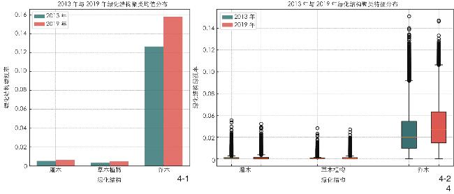
【目的】城市街道绿化结构的演变和优化是评价城市发展质量的重要指标,特别是在中国的典型城市上海,街道绿化对于改善城市微气候、减少空气污染以及提供居民休憩空间具有至关重要的作用。为了提升城市街道绿化质量,深入探究上海市中心城区在2013—2019年之间的城市街道绿化结构演变规律。【方法】基于时序街景图像数据,利用DeepLabV3+语义分割技术,详细分析上海市中心城区城市街道绿化结构的空间和时间演变规律。【结果】2013—2019年,上海城市街道绿化结构中的植物视觉要素占比有所增加,乔木、灌木和草本植物的视觉要素占比分别增加了25.09%、19.32%和42.39%。在街景的地理空间分布中,2019年综合性城市街道绿化结构(乔-灌-草)的数量相比2013年增加了23.99%,尤其是浦东新区和杨浦区的绿化结构增量变化更加明显。表明了城市街道绿化结构要素和绿化结构的增量具有空间分布一致性。【结论】基于人工智能技术的城市绿化监测方法能够有效识别城市街道绿化结构演变规律,为城市决策者和规划者提供了维护和增强城市绿化的全新视角。
王磊 , 章璇 , 韩昊英 , 何捷 . 基于时序街景数据的城市街道绿化结构演变——以上海市中心城区为例[J]. 风景园林, 2024 , 31(9) : 42 -50 . DOI: 10.3724/j.fjyl.202401070016
[Objective] For urban street space, a main place for residents’ daily public activities, its greening structure plays a crucial role in influencing walking index, environmental assessment, residents’ health and economic benefits. Street greening can significantly enhance residents’ life satisfaction, especially in high-density urban environments. With the development of computer technology, it has become possible to combine visual analysis techniques to conduct a fine-grained research on urban street greening structure. Studying the spatial and temporal evolution of street greening structure not only helps understand the spatial experience and landscape changes of urban streets, but also has great significance in scientifically evaluating and optimizing urban street greening, and promoting the high-quality and sustainable development of urban street space. Urban street greening structure is a three-dimensional plant composition concept, which usually includes high-level trees, mid-level shrubs and herbaceous plants. Through historical research and analysis of street view images, the research shows that traditional street greening measurements cannot effectively reflect the three-dimensional visual experience of residents, and therefore new methods are needed to more accurately analyze the greening structure of urban streets. In summary, the purpose of this research is to propose a new research framework to finely analyze the change trends and influence mechanisms at the level of urban street greening structure. Taking the Chinese city Shanghai as an example, the research adopts advanced artificial intelligence technology and time series street view data to conduct an in-depth research on the greening structure of urban streets.
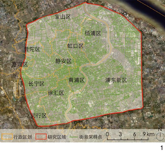
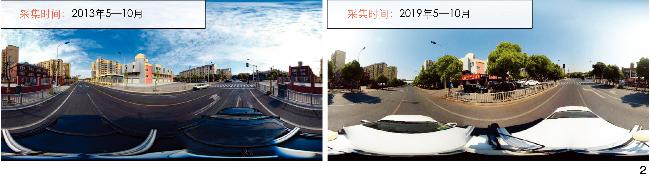
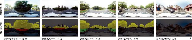
[Methods] At the data level, the road network is downloaded through OpenStreetMap, and street view sampling points are set at an interval of 50 m along the road network. Time series street view image data on the central urban area of Shanghai in summers during the period from 2013 and 2019 are collected via Baidu Map. At the model level, a self-annotated and trained deep learning model is used for semantic segmentation to identify green structures (trees, shrubs, and herbaceous plants) in the street view images. Combining multiple data sources, the DeepLabV3+ model is trained and migration learning is performed to improve accuracy and generalization. At the analysis level, statistical methods are used to classify and analyze the green structures in the street view images, taking into account the frequency and distribution of the green structures. The greening structures of Shanghai streets are classified into five categories based on the type of greening, and the spatial distribution and changes of these categories are analyzed.
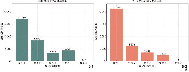
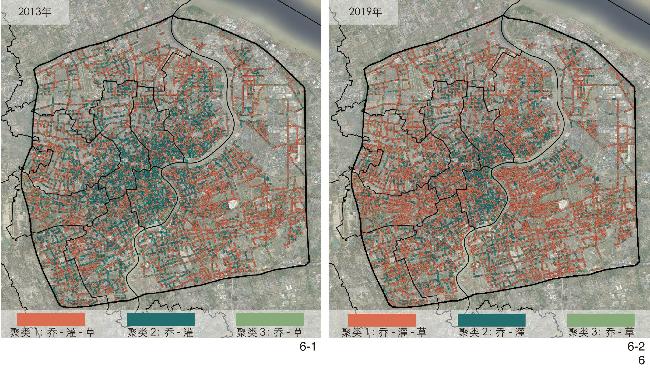
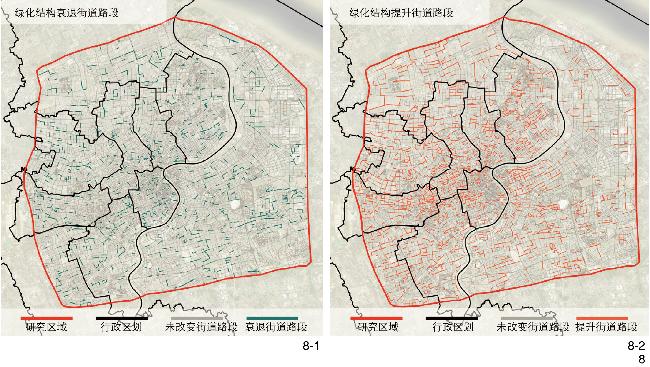
[Results] From 2013 to 2019, the urban street greening structure in the central urban area of Shanghai changed significantly. The results of the research show that the proportions of trees, shrubs and herbaceous plants increased by 25.09%, 19.32% and 42.39% respectively during the period from 2013 to 2019. This increase reflects the enrichment of the urban greening structure in terms of plant species and distribution. In particular, the comprehensive greening area (cluster 1) increased by 23.99% in 2019 compared to 2013, and the change was particularly significant in Pudong and Yangpu districts. The cluster analysis of the greening structure of urban streets shows that the spatial distribution and quantity of each type of greening structure also changed from 2013 to 2019. For example, both tree-dominated greening areas (cluster 4) and herb-dominated areas (cluster 3) show an increase in quantity, suggesting that urban planning has made progress in promoting diverse greening and improving ecological quality. In terms of the spatial distribution of the city, comprehensive greening areas in most administrative districts increased in 2019, reflecting the city’s continued investment in enhancing the living environment for residents and improving ecological functions. Especially in Pudong New Area, the vegetation changes were particularly significant due to the late development of the area, showing the positive adjustment of urban planning and greening strategies.
[Conclusion] In conclusion, it is in line with the requirements of the urban construction era to study the evolution and optimization strategies of urban street greening structures. At the level of policy and greening impact, Shanghai has promoted the quality of urban greening through the implementation of policies such as the Shanghai Greening Regulations. The policies have not only enhanced the aesthetics and functionality of green spaces, but also protected them through legal provisions and promoted community participation and environmental protection awareness. At the level of socio-economic benefits of greening structures, street greening can indirectly enhance property values by providing recreational space and improving the urban microclimate, and reduce public health expenditures by increasing biodiversity and improving air quality. At the level of classification and application of street greening structures, different street types require different greening structures to meet their functional needs according to their user groups and environmental characteristics. The dimension of greening structures and urban ecosystems emphasizes that through rational design of greening structures, the ecological system of the city can be enhanced, the microclimate improved, the biodiversity increased and the ecological network formed. This research can provide urban planners and policy makers with a new perspective on how to improve the quality of urban environment and residents’ life through urban street greening. It also points out the challenges in the process of urban greening, such as financial constraints and technical difficulties, and suggests appropriate solutions.
表1 上海城市街道绿化结构聚类的街景采样点数量Tab. 1 Number of street view sampling points involved in the clustering of urban street greening structure in Shanghai |
| 行政区 | 聚类1 | 聚类2 | 聚类3 | 聚类4 | 聚类5 | |||||||||
| 2013年 | 2019年 | 2013年 | 2019年 | 2013年 | 2019年 | 2013年 | 2019年 | 2013年 | 2019年 | |||||
| 宝山区 | 1 527 | 1 775 | 546 | 303 | 310 | 371 | 254 | 196 | 11 | 3 | ||||
| 长宁区 | 1 030 | 1 535 | 595 | 285 | 263 | 248 | 259 | 79 | 3 | 3 | ||||
| 虹口区 | 673 | 795 | 766 | 676 | 67 | 87 | 227 | 181 | 11 | 5 | ||||
| 黄浦区 | 631 | 839 | 805 | 778 | 166 | 133 | 399 | 245 | 19 | 25 | ||||
| 嘉定区 | 173 | 193 | 42 | 28 | 47 | 45 | 40 | 34 | 0 | 2 | ||||
| 静安区 | 920 | 1 486 | 1 161 | 871 | 151 | 170 | 479 | 191 | 17 | 10 | ||||
| 闵行区 | 775 | 1 015 | 393 | 206 | 171 | 243 | 293 | 177 | 11 | 2 | ||||
| 浦东新区 | 6 676 | 7 536 | 1 587 | 1 235 | 1 338 | 1 257 | 1 096 | 660 | 32 | 41 | ||||
| 普陀区 | 1 561 | 2 058 | 780 | 477 | 304 | 359 | 389 | 135 | 10 | 15 | ||||
| 徐汇区 | 1 551 | 1 913 | 906 | 783 | 312 | 315 | 531 | 285 | 9 | 13 | ||||
| 杨浦区 | 1 642 | 2 130 | 1 018 | 631 | 214 | 270 | 429 | 266 | 6 | 12 | ||||
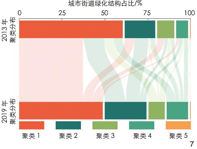
图7 城市街道绿化结构演变桑基分析图Fig. 7 Sankey diagram of the evolution of urban street greening structure |
表2 2013—2019年聚类的街景采样点数量转移矩阵Tab. 2 Number transfer matrix of street view sampling points in clustering from 2013 to 2019 |
| 2019年聚类1 | 2019年聚类2 | 2019年聚类3 | 2019年聚类4 | 2019年聚类5 | |
| 2013年聚类1 | 13 097 | 1 940 | | 573 | 23 |
| 2013年聚类2 | 4 374 | 2 854 | 617 | 716 | 38 |
| 2013年聚类3 | 1 944 | 338 | 734 | 322 | 5 |
| 2013年聚类4 | 1 818 | 1 102 | 607 | 819 | 50 |
| 2013年聚类5 | 42 | 39 | 14 | 19 | 15 |
文中图表均由作者绘制,
| [1] |
HASSEN N, KAUFMAN P. Examining the Role of Urban Street Design in Enhancing Community Engagement: A Literature Review[J]. Health and Place, 2016, 41: 119-132.
|
| [2] |
KI D, LEE S. Analyzing the Effects of Green View Index of Neighborhood Streets on Walking Time Using Google Street View and Deep Learning[J]. Landscape and Urban Planning, 2021, 205: 103920
|
| [3] |
THACKWAY W, NG M, LEE C L, et al. Implementing a Deep-Learning Model Using Google Street View to Combine Social and Physical Indicators of Gentrification[J]. Computers, Environment and Urban Systems, 2023, 102: 101970
|
| [4] |
HELBICH M, POPPE R, OBERSKI D, et al. Can’t See the Wood for the Trees? An Assessment of Street View- and Satellite-Derived Greenness Measures in Relation to Mental Health[J]. Landscape and Urban Planning, 2021, 214: 104181
|
| [5] |
LI X J, ZHANG C R, LI W D, et al. Who Lives in Greener Neighborhoods? The Distribution of Street Greenery and Its Association with Residents’ Socioeconomic Conditions in Hartford, Connecticut, USA[J]. Urban Forestry & Urban Greening, 2015, 14(4): 751-759.
|
| [6] |
LIN J, WANG Q, LI X. Socioeconomic and Spatial Inequalities of Street Tree Abundance, Species Diversity, and Size Structure in New York City[J]. Landscape and Urban Planning, 2021, 206(2): 103992
|
| [7] |
ROMAN L A, BATTLES J J, MCBRIDE J R. The Balance of Planting and Mortality in a Street Tree Population[J]. Urban Ecosystems, 2014, 17(2): 387-404.
|
| [8] |
HE D, MIAO J, LU Y, et al. Urban Greenery Mitigates the Negative Effect of Urban Density on Older Adults’ Life Satisfaction: Evidence from Shanghai, China[J]. Cities, 2022, 124: 103607
|
| [9] |
俞佳俐, 李健, 盛莹, 等. 城市绿地对居民身心健康福祉满意度影响研究[J]. 中国园林, 2021, 37(7): 95-100.
YU J L, LI J, SHENG Y, et al. Study on the Influence of Urban Green Space on the Satisfaction of Residents[J]. Chinese Landscape Architecture, 2021, 37(7): 95-100.
|
| [10] |
ZHANG F, ZHOU B, LIU L, et al. Measuring Human Perceptions of a Large-Scale Urban Region Using Machine Learning[J]. Landscape and Urban Planning, 2018, 180(12): 148-160.
|
| [11] |
成实, 张冠亭, 张潇涵, 等. 基于LiDAR点云的景观空间“绿视率”量化分析方法研究[J]. 中国园林, 2022, 38(2): 12-19.
CHENG S, ZHANG G T, ZHANG X H, et al. Research on the Quantitative Analysis Method of “Green Viewing Ratio” of Landscape Spatial Form Based on Three-Dimensional LiDAR Point Cloud Data[J]. Chinese Landscape Architecture, 2022, 38(2): 12-19.
|
| [12] |
WANG L, HAN X, HE J, et al. Measuring Residents’ Perceptions of City Streets to Inform Better Street Planning Through Deep Learning and Space Syntax[J]. ISPRS Journal of Photogrammetry and Remote Sensing, 2022, 190: 215-230.
|
| [13] |
GAO J, MA S, WANG L, et al. Does Greenness Bring More Green Travelling? Evidence from Free-Floating Bike-Sharing in Beijing[J]. Journal of Transport Geography, 2023, 109: 103586
|
| [14] |
FAN C, MYINT S W, ZHENG B. Measuring the Spatial Arrangement of Urban Vegetation and Its Impacts on Seasonal Surface Temperatures[J]. Progress in Physical Geography: Earth and Environment, 2015, 39(2): 199-219.
|
| [15] |
殷炜达, 苏俊伊, 许卓亚, 等. 基于遥感技术的城市绿地碳储量估算应用[J]. 风景园林, 2022, 29(5): 24-30.
YIN W D, SU J Y, XU Z Y, et al. Estimation and Application of Urban Green Space Carbon Storage Based on Remote Sensing Technology[J]. Landscape Architecture, 2022, 29(5): 24-30.
|
| [16] |
MATHEW A, KHANDELWAL S, KAUL N. Investigating Spatial and Seasonal Variations of Urban Heat Island Effect over Jaipur City and Its Relationship with Vegetation, Urbanization and Elevation Parameters[J]. Sustainable Cities and Society, 2017, 35: 157-177.
|
| [17] |
叶宇, 黄成成, 李心恬, 等. 人本视角街道绿视率与鸟瞰视角绿化覆盖率的表现差异及影响因素解析[J]. 风景园林, 2023, 30(9): 20-28.
YE Y, HUANG C C, LI X T, et al. Mapping the Differences Between Human-Scaled Visible Street Greenery vs. Green Coverage from Bird’s-Eye View and a Further Exploration of the Effecting Issues[J]. Landscape Architecture, 2023, 30(9): 20-28.
|
| [18] |
ZHU H, NAN X, YANG F, et al. Utilizing the Green View Index to Improve the Urban Street Greenery Index System: A Statistical Study Using Road Patterns and Vegetation Structures as Entry Points[J]. Landscape and Urban Planning, 2023, 237: 104780
|
| [19] |
BABINGTON A, HUGHES M, FARRELL C, et al. Preference for Multi-layered, Flowering, Woody Streetscape Plantings in a Mediterranean-Type Climate[J]. Urban Forestry & Urban Greening, 2023, 89: 128094
|
| [20] |
ZHOU B, ZHAO H, PUIG X, et al. Semantic Understanding of Scenes Through the ADE20K Dataset[J]. International Journal of Computer Vision, 2019, 127(3): 302-321.
|
| [21] |
CORDTS M, OMRAN M, RAMOS S, et al. The Cityscapes Dataset for Semantic Urban Scene Understanding[C/OL]// 2016 IEEE Conference on Computer Vision and Pattern Recognition (CVPR). Las Vegas: IEEE, 2016: 3213-3223[2023-10-01]. http://ieeexplore.ieee.org/document/7780719/.
|
| [22] |
KIM J. An Examination of the Spatial Coverage and Temporal Variability of Google Street View (GSV) Images in Small- and Medium-Sized Cities: A People-Based Approach[J]. Computers, Environment and Urban Systems, 2023, 102: 101956
|
| [23] |
唐婧娴, 龙瀛, 翟炜, 等. 街道空间品质的测度、变化评价与影响因素识别: 基于大规模多时相街景图片的分析[J]. 新建筑, 2016(5): 110-115.
TANG J X, LONG Y, ZHAI W, et al. Measuring Quality of Street Space, Its Temporal Variation and Impact Factors: An Analysis Based on Massive Street View Pictures[J]. New Architecture, 2016(5): 110-115.
|
| [24] |
TANG J X, LONG Y. Measuring Visual Quality of Street Space and Its Temporal Variation: Methodology and Its Application in the Hutong Area in Beijing[J]. Landscape and Urban Planning, 2019, 191: 103436
|
| [25] |
LI X J. Examining the Spatial Distribution and Temporal Change of the Green View Index in New York City Using Google Street View Images and Deep Learning[J]. Environment and Planning B: Urban Analytics and City Science, 2021, 48(7): 2039-2054.
|
| [26] |
张书杰, 李文竹, 龙瀛, 等. 基于多年街景图片的城市街道步行设施改善评价: 以中国45个城市为例[J]. 城市发展研究, 2022, 29(6): 53-64.
ZHANG S J, LI W Z, LONG Y, et al. Evaluation on the Improvement of Pedestrian Facilities with Multi-year Street View Images[J]. Urban Development Studies, 2022, 29(6): 53-64.
|
| [27] |
YU X, HER Y, HUO W, et al. Spatio-Temporal Monitoring of Urban Street-Side Vegetation Greenery Using Baidu Street View Images[J]. Urban Forestry and Urban Greening, 2022, 73: 127617
|
| [28] |
LIANG X, ZHAO T, BILJECKI F. Revealing Spatio-Temporal Evolution of Urban Visual Environments with Street View Imagery[J]. Landscape and Urban Planning, 2023, 237: 104802
|
| [29] |
上海市统计局. 气候[EB/OL]. (2018)[2024-08-01]. https://tjj.sh.gov.cn/zrdl/20180819/0014-216816.html.
Shanghai Bureau of Statistics. Climate[EB/OL]. (2018)[2024-08-01].https://tjj.sh.gov.cn/zrdl/20180819/0014-216816.html.
|
| [30] |
ZHANG L, WANG L, WU J, et al. Decoding Urban Green Spaces: Deep Learning and Google Street View Measure Greening Structures[J]. Urban Forestry & Urban Greening, 2023, 87(9): 128028
|
| [31] |
CHEN L C, ZHU Y, PAPANDREOU G, et al. Encoder-Decoder with Atrous Separable Convolution for Semantic Image Segmentation[C]// FERRARI V, HEBERT M, SMINCHISESCU C, et al. Computer Vision−ECCV 2018. Cham: Springer International Publishing, 2018: 833-851.
|
| [32] |
KIM Y, KIM Y. Global Regionalization of Heat Environment Quality Perception Based on K-Means Clustering and Google Trends Data[J]. Sustainable Cities and Society, 2023, 96: 104710
|
| [33] |
上海市城市管理行政执法局. 上海市绿化条例[EB/OL]. (2021)[2024-06-22]. https://cgzf.sh.gov.cn/channel_89/20210811/c9a5d3806fc84e458aeea58ced6d35cf.html.
Shanghai Urban Management and Law Enforcement Bureau. Regulations of Shanghai Municipality on Greening[EB/OL]. (2021)[2024-06-22]. https://cgzf.sh.gov.cn/channel_89/20210811/c9a5d3806fc84e458aeea58ced6d35cf.html.
|
| [34] |
YAO Y, XU C W, YIN H Y, et al. More Visible Greenspace, Stronger Heart? Evidence from Ischaemic Heart Disease Emergency Department Visits by Middle-Aged and Older Adults in Hubei, China[J]. Landscape and Urban Planning, 2022, 224: 104444
|
| [35] |
YAO Y, LU Y, GUAN Q, et al. Can Parkland Mitigate Mental Health Burden Imposed by the COVID-19? A National Study in China[J]. Urban Forestry & Urban Greening, 2022, 67: 127451
|
/
| 〈 |
|
〉 |