
基于精细时空行为测度的街道空间人群数字画像构建与分异
|
史宜/男/博士/东南大学建筑学院副教授、至善青年学者/中国城市科学研究会数字孪生与未来城市专委会委员/国际城市与区域规划师学会(ISOCARP)城市设计中心秘书长/研究方向为大数据在城市规划中的应用 |
|
戴运来/男/东南大学建筑学院在读硕士研究生/研究方向为城市中心区人群移动性 |
|
张珣/女/东南大学建筑学院在读博士研究生/研究方向为时空数据挖掘、人群移动性、城市活动空间 |
|
杨俊宴/男/博士/东南大学建筑学院教授/东南大学智慧城市研究院副院长/中国建筑学会高层建筑与人居环境学术委员会副主任/中国城市科学研究会城市更新专业委员会副主任/住建部城市设计专业委员会委员/研究方向为数字化城市设计 |
|
李秋莹/女/东南大学建筑学院在读硕士研究生/研究方向为城市中心区人群移动性 |
收稿日期: 2024-02-15
修回日期: 2024-07-26
网络出版日期: 2025-12-16
基金资助
国家自然科学基金面上项目“城市中心区“高密-高频”人流动态模拟与空间设计优化研究”(52378048)
版权
Research on the Construction and Differentiation Mechanism of Digital Portraits of Crowds in Street Space Based on Fine Spatiotemporal Behavior Measurement
|
SHI Yi, Ph.D., is an associate professor in the School of Architecture and a “Zhishan” (distinguished) young scholar in Southeast University, a member of the Digital Twin and Future City Professional Committee, Chinese Society for Urban Studies, and secretary-general of the Urban Design Center, International Society of City and Regional Planners (ISOCARP). His research focuses on application of big data in urban planning |
|
DAI Yunlai is a master student in the School of Architecture, Southeast University. His research focuses on population mobility in urban central area |
|
ZHANG Xun is a Ph.D. candidate in the School of Architecture, Southeast University. Her research focuses on spatiotemporal data mining, population mobility, and urban activity space |
|
YANG Junyan, Ph.D., is a professor in the School of Architecture, Southeast University, deputy director of the Smart City Research Institute, Southeast University, deputy director of the Academic Committee for High-Rise Buildings and Human Settlement Environments, Architectural Society of China, deputy director of the Urban Renewal Committee, Chinese Society for Urban Studies, and a member of the Urban Design Committee under the Ministry of Housing and Urban-Rural Development. His research focuses on digital urban design |
|
LI Qiuying is a master student in the School of Architecture, Southeast University. Her research focuses on population mobility in urban central area |
Received date: 2024-02-15
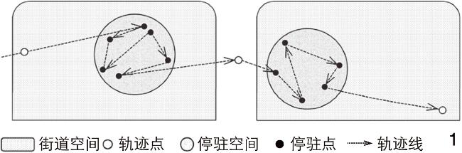
Revised date: 2024-07-26
Online published: 2025-12-16
Copyright
【目的】城市空间景观设计需要匹配多元化人群的实际活动需求,既有的数字技术方法更多从大尺度、宏观视角出发研究人群活动,难以满足景观尺度上对人群时空行为的智能画像研究。从景观-建筑尺度深入探讨面向街道设计的人群数字画像识别指标体系与测度方法,可为理解街道建成环境与人群分异之间的互动机制提供依据。【方法】以江苏省南京市中央路为案例,通过采集基于手机定位服务(location-based services, LBS)的人群时空数据和街道空间数据,运用人工智能算法分析不同类型人群的街道空间时空使用特征;提出包含基本属性、时间偏好、空间偏好、设施偏好和景观偏好等多维度指标的街道空间人群数字画像测度方法和谱系构建方法。【结果】识别出213种街道空间人群类型和7类典型人群数字画像,揭示了街道空间人群数字画像的时空分异特征,发现了这些特征与现状街道景观设计和设施布局的关联性。【结论】基于街道空间人群数字画像的分析结果,针对性地提出提升街道空间品质的规划建议,有助于更好地满足不同人群的实际活动需求,以助力城市空间景观设计响应居民需求,从而创造更加宜居、舒适的城市环境。
史宜 , 戴运来 , 张珣 , 杨俊宴 , 李秋莹 . 基于精细时空行为测度的街道空间人群数字画像构建与分异[J]. 风景园林, 2024 , 31(9) : 24 -33 . DOI: 10.3724/j.fjyl.202402150092
[Objective] Street space, as an indispensable landscape space, is deeply embedded in the urban texture and has become an important carrier for citizens’ social life. It is not only a channel for traffic flow, but also a source of urban vitality and a place for citizens to place their emotions. Throughout history, street space design theory has gone through the solemnity of classicism, the pursuit of efficiency of functionalism, and the exploration of harmonious coexistence between ecology and nature, and has, under the guidance of humanistic thought, given birth to design concepts such as “vibrant street” and “shared street” with citizen experience as the core. These concepts have profoundly reshaped our cognition and expectations of street space. The research on crowd activities in street space aims to reveal the types and characteristics of activities, understand the inherent connection between design and behavior, and provide a scientific basis for street environment optimization and resource allocation. This will not only help activate urban vitality, but also lead street space to develop in a more humane and diversified direction. In order to accurately match the urban space landscape design with the actual activity needs of diversified crowds, this research aims to overcome the limitations of existing digital technologies in large-scale macro-activity analysis, deeply explore the crowd behavior patterns at the landscape scale, and provide new perspectives and tools for understanding the complex interactive mechanism between the built street environment and the differentiation of crowd activities, thereby guiding the optimization and upgrading of urban street space.
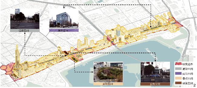
[Methods] With the rapid development of artificial intelligence algorithms and the location-based services (LBS) data technology, this research makes full use of these advanced technologies and conducts an empirical study in a typical area of Zhongyang Road along the Central Axis of Nanjing. By collecting and analyzing fine spatiotemporal data based on mobile phone LBS and street space data, the research uses advanced artificial intelligence algorithms to deeply explore the activity characteristics of different crowds in street space. This method not only covers basic attribute analysis, but also deeply explores multi-dimensional indicators such as time preference, space preference, facility preference and landscape preference of crowds, laying a solid foundation for the measurement and genealogy of digital portraits of crowds in street space.
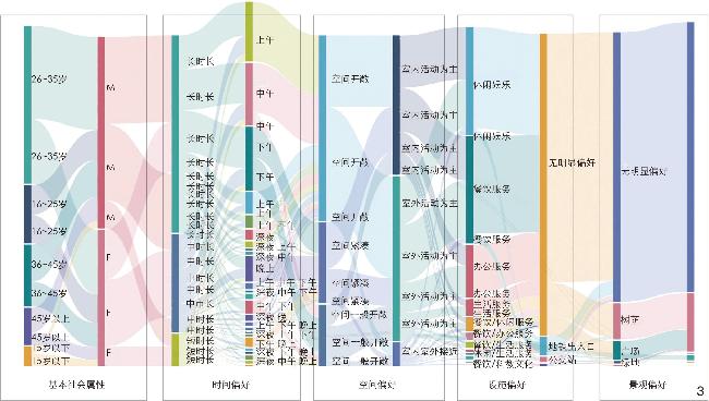
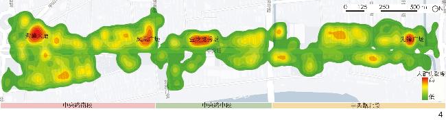
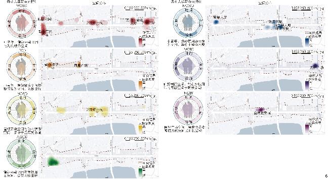
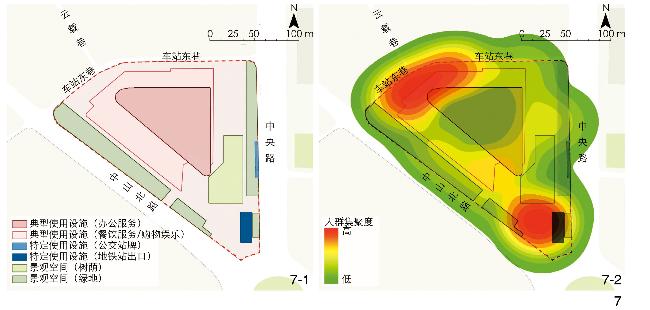
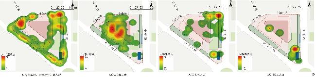
[Results] This research successfully constructs a digital portrait system of crowds in street space containing multi-dimensional indicators, and reveals 213 different types of crowds in street space and their behavioral characteristics in Zhongyang Road along the Central Axis of Nanjing through data analysis. Furthermore, the research summarizes the digital portraits of 7 typical crowds, including selecting portrait groups with a size of more than 2% of the total population from 213 types of digital portraits as typical groups of street space users. The specific portrait categories include the MOBD crowd featuring long duration, morning, open space, shopping and entertainment, and no preference, the ITCD crowd featuring medium duration, evening, compact space, catering service, and no preference, the NOBD crowd featuring long duration, noon, open space, shopping and entertainment, and no preference, the AGCD crowd featuring long duration, afternoon, general space, catering service, and no preference, the NOWD crowd featuring long duration, noon, open space, office service, and no preference, the MOBS crowd featuring long duration, morning, open space, shopping and entertainment, and shade preference, and the NOBP crowd featuring long duration, noon, open space, shopping and entertainment, and plaza preference. These portraits not only reflect the spatiotemporal use patterns of crowds in street space, but also reveal the underlying differentiation characteristics. In addition, this research also deeply analyzes the correlation between these crowd portraits and the current street landscape design and facility layout, providing strong support for understanding the interaction between street space environment and crowd activities. Further, this research takes Zifeng Block as an example to analyze the aggregation and flow characteristics of crowds in street space. Through portrait clustering and feature analysis, the intrinsic connection between the tempospatial differentiation of the crowds and factors such as individual attributes, built environment and time is revealed. The research finds that the crowds in the street space of Zifeng Block mainly gather near the subway entrances and exits or branch stations, and there exist significant differences in the composition of the crowds in different time periods. On weekday mornings, the area dominated by commercial office buildings typically attracts a large number of office workers, forming a long-term office service crowd; while in the evening and at night, the rich entertainment facilities attract more consumers. In addition, the crowds have a high demand for the quality of landscape space, but the accessibility of the existing square green space is limited, which affects their willingness to stay. The research also points out that Zifeng Block needs to further optimize the settings of street furniture, green landscape, etc., to improve the quality of street space and enhance its attractiveness to pedestrians. These insights are of great reference value for urban planning and decision-making, and can help create a more livable and business-friendly urban environment.
[Conclusion] This research not only enriches the research content on crowd behavior patterns in urban space, but also proposes a method for constructing digital portraits of crowds in street space based on fine spatiotemporal behavior measurement. By revealing the spatiotemporal differentiation characteristics of the digital portraits of crowds in street space and their correlation with the built street environment, this research provides a scientific basis and practical guidance for urban street design. Based on these findings, the research puts forward targeted planning response suggestions, aiming to guide the improvement of spatial quality by optimizing street space design, so as to better meet the actual activity needs of different crowds and promote the harmonious and sustainable development of the city.
表1 街道空间人群数字画像识别指标体系Tab. 1 Indicator system for digital portraits recognition of crowds in street space |
| 属性 | 指标 | 描述 | 量化解释 | |
| 基本社会 属性 | A年龄 | 来源于通信运营商提供的脱敏定位服务(location-based services, LBS)数据 | A1:15岁以下 A2:16~25岁 A3:26~35岁 A4:36~45岁 A5:45岁以上 | |
| B性别 | B1:男性(M) B2:女性(F) | |||
| 行为偏好 属性 | C时间偏好 | C1平均停驻时长 | 一定空间范围内个体行为链中若干停驻点的平均驻留时间 | C1=$\dfrac{ {T}_{总} }{n},$ (1) 式中:$ {T}_{总} $为个体行为链在一定空间范围内停驻的总时长;$ n $为停驻的总次数 |
| C2高频停驻时段 | 个体行为链的典型活动时段 | C2=0,1,2,…,23(各数字代表一天中的不同时段) | ||
| D空间偏好 | D1室外街道空间的空间开敞度偏好 | 个体室外活动停驻街区的开敞空间面积与街区建筑总面积比值的平均值 | D1=$ \dfrac{\displaystyle\sum {\mathrm{O}\mathrm{S}\mathrm{R}}_{i}}{{n}_{1}},$ (2) 式中:$ {\mathrm{O}\mathrm{S}\mathrm{R}}_{i} $为个体停驻街区$ i $的开敞度,即街区开敞空间面积与街区建筑总面积的比值;$n_1 $为个体停驻的街区数量 | |
| D2室内外停驻比 | 个体行为链活动范围内室内停驻时间与室外停驻时间的比值 | D2=$ \dfrac{{T}_{\mathrm{i}\mathrm{n}}}{{T}_{\mathrm{o}\mathrm{u}\mathrm{t}}} $, (3) 式中:$T_{\text{in}} $指室内停驻时间;$T_{\text{out}} $指室外停驻时间 | ||
| E设施偏好 | E1典型使用设施 | 基于设施使用行为链中驻留次数最多的停驻点设施特征识别 | 餐饮服务、购物娱乐、办公服务、生活服务、住宿服务、科教文化6类设施 | |
| E2特定使用设施 | E2-1:地铁站出口 E2-2:公交站牌 E2-3:充电桩 | |||
| F景观偏好 | F1典型偏好景观 | 基于户外游憩型行为链中驻留次数最多的停驻点设施特征识别 | F1-1:滨水空间 F1-2:树荫空间 F1-3:绿地 F1-4:广场 | |
| F2景观空间偏好值 | 户外游憩型行为到访景观空间的绿地率和公共交通覆盖率乘积的平均值 | F2=$ \dfrac{\displaystyle\sum ({L}_{i}\times {P}_{i})}{{n}_{2}} $, (4) 式中:$ {L}_{i} $为景观空间$i $的绿地率;$ {P}_{i} $为景观空间$i $的公共交通覆盖率;$ {n}_{2} $为个体停驻的景观空间数量 | ||
表3 典型人群时空偏好统计Tab. 3 Statistics of spatiotemporal preferences of typical crowds |
| 典型人群类型 | 时间 | 空间 | 设施 | 景观 | 人数占比/% |
| MOBD | 长时长、早上(M) | 空间开敞(O) | 购物娱乐(B) | 无偏好(D) | 4.43 |
| ITCD | 中时长、晚上(I) | 空间紧凑(T) | 餐饮服务(C) | 无偏好(D) | 4.10 |
| NOBD | 长时长、中午(N) | 空间开敞(O) | 购物娱乐(B) | 无偏好(D) | 3.87 |
| AGCD | 长时长、下午(A) | 空间一般开敞(G) | 餐饮服务(C) | 无偏好(D) | 3.39 |
| NOWD | 长时长、中午(N) | 空间开敞(O) | 办公服务(W) | 无偏好(D) | 2.86 |
| MOBS | 长时长、早上(M) | 空间开敞(O) | 购物娱乐(B) | 树荫偏好(S) | 2.29 |
| NOBP | 长时长、中午(N) | 空间开敞(O) | 购物娱乐(B) | 广场偏好(P) | 2.11 |
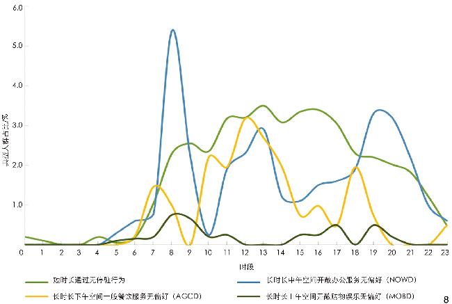
表4 紫峰街区街道空间中典型人群统计Tab. 4 Statistics of typical crowds in the street space of Zifeng Block |
| 典型人群类型 | 人数占比/% |
| 短时长通过、无停驻行为 | 30.76 |
| NOWD | 28.59 |
| AGCD | 25.36 |
| MOBD | 10.36 |
| ITCD | 1.65 |
| NOBD | 1.60 |
| 其他类人群 | 1.68 |
文中图表均由作者绘制,其中
| [1] |
雅各布斯.美国大城市的死与生[M].南京: 译林出版社, 2006: 26.
JACOBS J. The Death and Life of Great American Cities[M]. Nanjing: Yilin Press, 2006: 26.
|
| [2] |
邱书杰. 作为城市公共空间的城市街道空间规划策略[J]. 建筑学报, 2007(3): 9-14.
QIU S J. Urban Street Space Planning Strategies as Urban Public Space[J]. Architectural Journal, 2007(3): 9-14.
|
| [3] |
高巍, 贾梦涵, 赵玫, 等. 街道空间研究进展与量化测度方法综述[J]. 城市规划, 2022, 46(3): 106-114.
GAO W, JIA M H, ZHAO M, et al. Review of Research Progress and Quantitative Measurement Methods in Street Space[J]. City Planning Review, 2022, 46(3): 106-114.
|
| [4] |
王建国. 包容共享、显隐互鉴、宜居可期: 城市活力的历史图景和当代营造[J]. 城市规划, 2019, 43(12): 9-16.
WANG J G. Inclusive Sharing, Mutual Learning of the Visible and Invisible, and Livable Expectations: Historical Landscape and Contemporary Construction of Urban Vitality[J]. City Planning Review, 2019, 43(12): 9-16.
|
| [5] |
陈泳, 赵杏花. 基于步行者视角的街道底层界面研究: 以上海市淮海路为例[J]. 城市规划, 2014, 38(6): 24-31.
CHEN Y, ZHAO X H. Research on the Street Interface from the Walker’s Perspective: A Case Study of Huaihai Road in Shanghai[J]. City Planning Review, 2014, 38(6): 24-31.
|
| [6] |
徐磊青, 康琦. 商业街的空间与界面特征对步行者停留活动的影响: 以上海市南京西路为例[J]. 城市规划学刊, 2014(3): 104-111.
XU L Q, KANG Q. The Impact of Commercial Street Spatial and Interface Characteristics on Walker’s Staying Activities: A Case Study of West Nanjing Road in Shanghai[J]. Urban Planning Forum, 2014(3): 104-111.
|
| [7] |
唐婧娴, 龙瀛. 特大城市中心区街道空间品质的测度: 以北京二三环和上海内环为例[J]. 规划师, 2017, 33(2): 68-73.
TANG J X, LONG Y. Measurement of Street Space Quality in the Central Area of Megacities: A Case Study of Beijing’s Second and Third Ring Roads and Shanghai’s Inner Ring[J]. Planners, 2017, 33(2): 68-73.
|
| [8] |
龙瀛, 唐婧娴. 城市街道空间品质大规模量化测度研究进展[J]. 城市规划, 2019, 43(6): 107-114.
LONG Y, TANG J X. Research Progress on Large-Scale Quantitative Measurement of Urban Street Space Quality[J]. City Planning Review, 2019, 43(6): 107-114.
|
| [9] |
叶宇, 张昭希, 张啸虎, 等. 人本尺度的街道空间品质测度: 结合街景数据和新分析技术的大规模、高精度评价框架[J]. 国际城市规划, 2019, 34(1): 18-27.
YE Y, ZHANG Z X, ZHANG X H, et al. Human-Scale Measurement of Street Space Quality: A Large-Scale, High-Precision Evaluation Framework Combined with Street View Data and New Analytical Techniques[J]. Urban Planning International, 2019, 34(1): 18-27.
|
| [10] |
黄丹, 戴冬晖. 生活性街道构成要素对活力的影响: 以深圳典型街道为例[J]. 中国园林, 2019, 35(9): 89-94.
HUANG D, DAI D H. The Impact of Living Street Elements on Vitality: A Case Study of Typical Streets in Shenzhen[J]. Chinese Landscape Architecture, 2019, 35(9): 89-94.
|
| [11] |
钮心毅, 吴莞姝, 李萌. 基于LBS定位数据的建成环境对街道活力的影响及其时空特征研究[J]. 国际城市规划, 2019, 34(1): 28-37.
NIU X Y, WU W S, LI M. Research on the Impact of Built Environment on Street Vitality and Its Spatiotemporal Characteristics Based on LBS Positioning Data[J]. Urban Planning International, 2019, 34(1): 28-37.
|
| [12] |
吴莞姝, 马子迎, 郭金函, 等. 建成环境对街道活力的非线性效应: 基于XGBoost模型的多源大数据分析[J]. 中国园林, 2022, 38(12): 82-87.
WU W S, MA Z Y, GUO J H, et al. Non-linear Effects of Built Environment on Street Vitality: A Multi-source Big Data Analysis Based on XGBoost Model[J]. Chinese Landscape Architecture, 2022, 38(12): 82-87.
|
| [13] |
张健. 城市空间与城市设计: 公共空间引领的城市设计[M].北京: 清华大学出版社, 2016.
ZHANG J. Urban Space and Urban Design: Urban Design Led by Public Space[M]. Beijing: Tsinghua University Press, 2016.
|
| [14] |
蔡冰. 城市更新视野下的街道景观实践[J]. 中国园林, 2021, 37(S2): 62-66.
CAI B. Street Landscape Practice from the Perspective of Urban Renewal[J]. Chinese Landscape Architecture, 2021, 37(S2): 62-66.
|
| [15] |
徐磊青, 施婧. 步行活动品质与建成环境: 以上海三条商业街为例[J]. 上海城市规划, 2017(1): 17-24.
XU L Q, SHI J. Pedestrian Activity Quality and Built Environment: A Case Study of Three Commercial Streets in Shanghai[J]. Shanghai Urban Planning Review, 2017(1): 17-24.
|
| [16] |
梁思思. 街道空间安全[J]. 住区, 2018(6): 80
LIANG S S. Street Space Safety[J]. Design Community, 2018(6): 80
|
| [17] |
杨俊宴, 吴浩, 郑屹. 基于多源大数据的城市街道可步行性空间特征及优化策略研究: 以南京市中心城区为例[J]. 国际城市规划, 2019, 34(5): 33-42.
YANG J Y, WU H, ZHENG Y. Research on Walkability Spatial Characteristics and Optimization Strategies of Urban Streets Based on Multi-Source Big Data: A Case Study of Central Urban Area in Nanjing[J]. Urban Planning International, 2019, 34(5): 33-42.
|
| [18] |
杨俊宴, 金探花, 史宜, 等. 基于大数据的城市人群数字画像: 技术与实证[J]. 城市规划, 2023, 47(4): 45-54.
YANG J Y, JIN T H, SHI Y, et al. Digital Portrait of Urban Crowd Based on Big Data: Technology and Empirical Analysis[J]. City Planning Review, 2023, 47(4): 45-54.
|
| [19] |
张珣.面向精准规划的城市人群数字画像研究[D].南京: 东南大学, 2022.
ZHANG X. Research on Digital Portrait of Urban Crowd for Precise Planning[D]. Nanjing: Southeast University, 2022.
|
| [20] |
金探花.基于LBS数据的城市人群画像研究[D]. 南京: 东南大学, 2019.
JIN T H. Research on Urban Crowd Portrait Based on LBS Data[D]. Nanjing: Southeast University, 2019.
|
| [21] |
杨俊宴, 夏歌阳, 薛琴, 等. 基于人群数字画像的高铁新城功能设施布局与优化研究: 以杭州南站为例[J]. 新建筑, 2023(2): 126-131.
YANG J Y, XIA G Y, XUE Q, et al. Research on Functional Facility Layout and Optimization of High-Speed Rail New Town Based on Digital Portrait of Crowd: A Case Study of Hangzhou South Station[J]. New Architecture, 2023(2): 126-131.
|
| [22] |
杨俊宴, 何国枫, 陈代俊, 等. 城市交通拥堵地区人群数字画像解析与空间规划应对[J]. 规划师, 2021, 37(19): 26-34.
YANG J Y, HE G F, CHEN D J, et al. Analysis and Spatial Planning Response to Urban Traffic Congestion Area Crowd Digital Portrait[J]. Planners, 2021, 37(19): 26-34.
|
| [23] |
赵一帆, 张训一, 张源铭, 等. 基于人群时空行为画像的社区精准规划策略: 以南京阅江楼社区为例[J]. 规划师, 2022, 38(9): 108-116.
ZHAO Y F, ZHANG X Y, ZHANG Y M, et al. Community Precise Planning Strategies Based on Crowd Spatiotemporal Behavior Portrait: A Case Study of Yuejianglou Community in Nanjing[J]. Planners, 2022, 38(9): 108-116.
|
| [24] |
王灿, 王德, 朱玮, 等. 基于消费者行为的商业空间绩效评价体系建构[J]. 城市规划, 2021, 45(3): 33-45.
WANG C, WANG D, ZHU W, et al. Construction of Commercial Space Performance Evaluation System Based on Consumer Behavior[J]. City Planning Review, 2021, 45(3): 33-45.
|
| [25] |
吴屹豪, 庄宇. 高密度城市人口动静集聚与街坊形态关联解析: 基于曼哈顿的实证[J]. 城市规划, 2024, 48(6): 36-46.
WU Y H, ZHUANG Y. Analysis of the Correlation Between Dynamic and Static Population Agglomeration and Urban Block Morphology in High-Density Cities: An Empirical Study Based on Manhattan[J]. City Planning Review, 2024, 48(6): 36-46.
|
| [26] |
王宝强, 陈娴, 施澄. 基于多源数据的武汉市环城游憩空间特征解析[J]. 中国园林, 2021, 37(6): 49-54.
WANG B Q, CHEN X, SHI C. Analysis of Recreational Spatial Features of Wuhan City Based on Multi-source Data[J]. Chinese Landscape Architecture, 2021, 37(6): 49-54.
|
| [27] |
项振海, 李青, 班鹏飞, 等. 历史街区中人群活动偏好的主体差异及其影响因素: 以昆明市文明街历史街区为例[J]. 中国名城, 2022, 36(11): 86-93.
XIANG Z H, LI Q, BAN P F, et al. Subject Differences and Influencing Factors of Crowd Activity Preferences in Historic Districts: A Case Study of Wenming Street Historic District in Kunming City[J]. China Ancient City, 2022, 36(11): 86-93.
|
| [28] |
娄健坤, 蔺阿琳.基于叙述性偏好法的街道绿色空间景观偏好研究[C]//中国城市规划学会.面向高质量发展的空间治理: 2021中国城市规划年会论文集(12风景环境规划).北京: 中国建筑工业出版社, 2021.
LOU J K, LIN A L. Research on Landscape Preferences of Street Green Spaces Based on Narrative Preference Method[C]// Urban Planning Society of China. Spatial Governance for High-Quality Development: Proceedings of the 2021 Annual Conference of Urban Planning in China (Volume 12: Landscape and Environmental Planning). Beijing: China Architecture & Building Press, 2021.
|
| [29] |
张小佳, 孙然然, 李晓璐, 等. 基于最小覆盖圆时空聚类算法的出行轨迹停驻点识别[J]. 科学技术与工程, 2020, 20(28): 11782-1178.
ZHANG X J, SUN R R, LI X L, et al. Travel Trajectory Stop Point Recognition Based on Minimum Covered Circle Temporal-Spatial Clustering Algorithm[J]. Science Technology and Engineering, 2020, 20(28): 11782-1178.
|
| [30] |
周洋, 杨超. 基于时空聚类算法的轨迹停驻点识别研究[J]. 交通运输系统工程与信息, 2018, 18(4): 88-95.
ZHOU Y, YANG C. Anchors Identification in Trajectory Based on Temporospatial Clustering Algorithm[J]. Journal of Transportation Systems Engineering and Information Technology, 2018, 18(4): 88-95.
|
| [31] |
HU X Y, REN Y F, TAN Y, et al. Research on the Spatial and Temporal Dynamics of Crowd Activities in Commercial Streets and Their Relationship with Formats: A Case Study of Lao Men Dong Commercial Street in Nanjing[J]. Sustainability, 2023, 15(24): 16838
|
| [32] |
王梓蒙, 刘艳芳, 罗璇, 等. 基于多源数据的城市活力与建成环境非线性关系研究: 以双休日武汉市主城区为例[J]. 地理科学进展, 2023, 42(4): 716-729.
WANG Z M, LIU Y F, LUO X, et al. Nonlinear Relationship Between Urban Vitality and the Built Environment Based on Multi-source Data: A Case Study of the Main Urban Area of Wuhan City at the Weekend[J]. Progress in Geography, 2023, 42(4): 716-729.
|
/
| 〈 |
|
〉 |