
基于NSGA-Ⅱ算法的绿色基础设施多目标空间优化
|
刘颂/女/博士/同济大学建筑与城市规划学院教授、博士生导师/高密度人居环境生态与节能教育部重点实验室数字景观模拟实验室负责人/上海城市困难立地绿化工程技术研究中心副主任/研究方向为城乡绿地系统规划、景观规划技术方法 |
|
董宇翔/男/宾夕法尼亚州立大学在读博士研究生/研究方向为风景园林规划与设计、数字景观与智能决策 |
|
裴新生/男/硕士/注册城乡规划师/上海同济城市规划设计研究院有限公司副院长、教授级高级工程师/研究方向为国土空间规划、战略规划 |
|
王颖/女/硕士/上海同济城市规划设计研究院有限公司总工/研究方向为国土空间总体规划 |
收稿日期: 2023-06-16
网络出版日期: 2025-12-15
基金资助
国家自然科学基金面上项目“基于生态系统服务权衡与协同的市级生态空间多目标优化研究”(52178050)
上海同济城市规划设计研究院有限公司暨长三角城市群智能规划协同创新中心科研课题“基于多效益协同最优的绿色基础设施景观格局特征研究”(KY-2022-YB-A05)
版权
Multi-objective Spatial Optimization of Green Infrastructure Based on NSGA-Ⅱ Algorithm
|
LIU Song, Ph.D., is a professor and doctoral supervisor in the College of Architecture and Urban Planning (CAUP), Tongji University, person in charge of DLA sub-lab of the Key Laboratory of Ecology and Energy-Saving Study of Dense Habitat, Ministry of Education, and deputy director of Shanghai Engineering Research Center of Landscaping on Challenging Urban Sites. Her research focuses on planning of urban and rural green space systems, and techniques and methods for landscape planning |
|
DONG Yuxiang is a Ph.D. student at Pennsylvania State University. His research focuses on landscape planning and design, and digital landscape and intelligent decision-making |
|
PEI Xinsheng, Master, certified urban-rural planner, is vice president of and a professorate senior engineer in Shanghai Tongji Urban Planning & Design Institute Co., Ltd. His research focuses on territorial spatial planning and strategic planning |
|
WANG Ying, Master, is chief engineer of Shanghai Tongji Urban Planning & Design Institute Co., Ltd. Her research focuses on overall territorial spatial planning |
Received date: 2023-06-16
Online published: 2025-12-15
Copyright
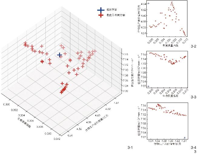
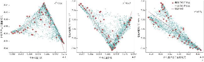
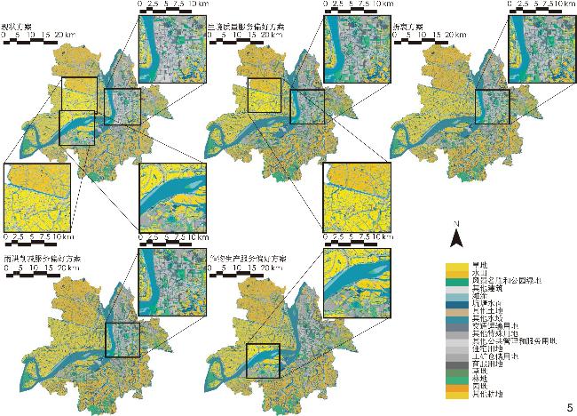
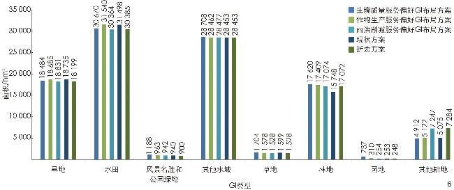
【目的】绿色基础设施(green infrastructure, GI)是提供多种生态系统服务、保护区域生态系统安全和稳定的重要载体,而GI所能供给的各项生态系统服务之间的权衡关系导致GI的规划决策难以同时最大化多项服务供给。旨在以多项生态系统服务供给协同增益为目标构建一个辅助GI规划决策的多目标空间优化模型。【方法】基于NSGA-Ⅱ算法,以InVEST模型构建目标函数,在Python开发了协同生境质量服务、作物生产服务、雨洪削减服务3项主导生态系统服务的GI布局优化模型,并在安徽省芜湖市中心城区进行了应用。【结果】优化模型共获取50个末代帕累托最优GI布局,据此遴选出不同服务偏好下的GI布局方案,各方案相应服务供给能力得到显著提升:生境质量目标偏好方案的全局平均生境质量指数从现状方案的0.298 8提升至0.311 5;雨洪削减服务目标偏好方案的径流滞蓄量从70 189.34 mm/a提升至71 673.20 mm/a;作物生产目标偏好方案将作物生产总价值量从464 169.51万元提升至464 582.90万元;折衷方案的雨洪削减服务供给能力和生境质量服务供给能力优于现状方案,其径流滞蓄量和生境质量指数分别达到71 658.67 mm/a和0.299 3,而在作物生产服务供给能力上并没有实现对现状方案的提升。根据优化结果分析了GI供给的各项服务间的权衡与协同关系,归纳了在各种服务偏好下和协同多项服务时的GI空间布局特征。【结论】多目标优化算法为辅助协同多项生态系统服务的GI布局决策、探索生态系统服务间权衡与协同关系、明确不同服务目标导向下的GI空间规划策略提供了重要参考,为国土空间规划视角下采用模型算法辅助生态空间及GI规划的实践提供了有力工具。
刘颂 , 董宇翔 , 裴新生 , 王颖 . 基于NSGA-Ⅱ算法的绿色基础设施多目标空间优化[J]. 风景园林, 2024 , 31(4) : 95 -103 . DOI: 10.3724/j.fjyl.202306160277
[Objective] Green infrastructure (GI) is an important carrier for providing diverse ecosystem services and safeguarding the security and stability of regional ecosystems. Nevertheless, the trade-off relationship between various ecosystem services that GI can provide makes it difficult for GI planning decision to simultaneously maximize multiple service provisions. This research aims to construct a multi-objective spatial optimization model for GI planning with the goal of maximizing multiple ecosystem service provisions, and to provide succinct recommendations and technical guidelines for ecological spatial and GI planning within the framework of territorial spatial planning.
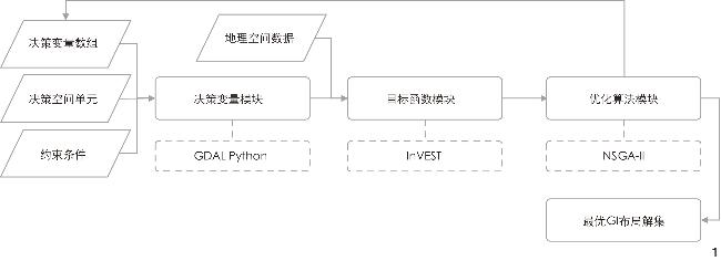
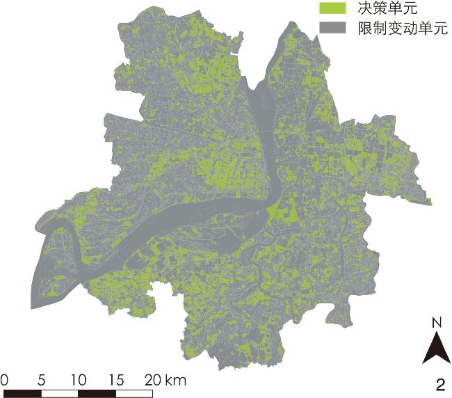
[Methods] Based on the NSGA-Ⅱ optimization algorithm, the GI planning optimization model for maximizing 3 ecosystem services (i.e., habitat quality, crop production, and runoff reduction) is constructed and applied to the central urban area of Wuhu, Anhui Province. The optimization model contains four parts: decision variables, constraints, objective functions, and the optimization algorithm. Decision variables determine the spatial location and type of GI, thus generating a variety of GI layout schemes, while constraints ensure that these schemes comply with certain requirements. Subsequently, the objective functions calculate the values for three critical ecosystem services, thereby representing the capacity of GI schemes to supply multiple ecosystem services. The InVEST − Crop Production Regression Model, InVEST − Habitat Quality Model, and InVEST − Urban Flood Risk Mitigation Model are used as objective functions for quantifying ecosystem services of crop production, habitat quality, and runoff reduction. The NSGA-Ⅱ algorithm can, through multiple iterations, generate GI schemes and obtain the objective function values of various ecosystem services, with the aim of maximizing multiple services and determining the optimal GI layout solution set. The research also analyzes the trade-offs and synergistic relationships among the three key ecosystem services through scatter distribution trends and curve fitting based on the optimization results. By comparing the optimal GI layout for each objective preference scheme, the optimal GI layout for each service trade-off, and the spatial layout differences of the algorithm for each GI type under the current scheme, the GI layout strategy for synergizing multiple ecosystem services in the research area is clarified.
[Results] The optimization model yields a corpus of 50 Pareto-optimal planning solutions for GI. The optimized GI planning solutions demonstrate substantially improved capacity to provide ecosystem services, contingent upon differential service preferences. The compromise scheme outperforms the current scheme in providing runoff reduction service and habitat quality service, the crop production yield and habitat quality index of which reach 71,658.67 mm/a and 0.2993 respectively, while failing to achieve an upgrade in providing crop production service over the current scheme. Synthesizing the optimization findings, the trade-offs and synergies between various ecosystem services provided by GI are delineated. Further, the research proposes the spatial layout characteristics of GI under each objective preference and for synergizing multiple services, which are as follows: Under the habitat quality preference, add forest and grass space in urban areas, and decentralize the placement of habitat patches; under the crop production preference, maintain the current agricultural pattern, and increase the proportion of riverside farmland; under the rainwater runoff reduction preference, increase the storage capacity of urban areas, and construct a flood regulating network; and in the case of compromising the three services, increase the proportion of multifunctional GI, and pay attention to the composite enhancement of the services.
[Conclusion] Utilizing the NSGA-Ⅱ algorithm and the InVEST model, this research innovatively develops a synergistic optimization model for GI spatial layouts. The results illuminate the trade-offs and synergies between services, which may guide the spatial planning of GI under diverse service preferences. The research demonstrates that multi-objective optimization can significantly aid in GI planning toward enhancing ecosystem service supply and informing spatial strategies. It also highlights specific GI layout characteristics for various service preference schemes, bridging the gap between ecosystem service theory and practical GI planning, and laying a foundation for future research on efficient service provision and service synergy understanding. However, this research has some limitations, particularly in its simplified modeling process due to the generality of the InVEST model and the uncertainty in data precision, potentially leading to skewed results. Future work requires refined models and high-precision data for validation. Additionally, the GI classification based on land use, layout rules, and constraints entail the enhancement of practical implementation and a deeper understanding of the ecosystem service provision mechanisms.
表1 本研究使用的数据及来源Tab. 1 Data and sources used in this research |
| 数据名称 | 数据类型(精度) | 用途或描述 | 来源 |
|---|---|---|---|
| 芜湖市土地利用现状数据 | 矢量数据 | 用于生成土地利用栅格数据,进行InVEST模型的生态系统服务测算,作为优化部分的决策空间单元 | 上海同济城市规划设计研究院有限公司 |
| 芜湖市中心城区边界 | 矢量数据 | 用于确定研究区域范围,提取相关数据 | 上海同济城市规划设计研究院有限公司 |
| 平均参考蒸散发数据 | 栅格数据(1 km) | 用于InVEST模型径流削减模型的输入参数 | 全球干旱度指数和潜在蒸发量(reference evapotranspiration, ET0)气候数据库[22] |
| 土壤水文分组数据 | 栅格数据(1 km) | 用于InVEST模型径流削减模型的输入参数 | Futruewater全球土壤水力特性地图数据[23] |
表2 决策变量定义Tab. 2 Definition of decision variable |
| 土地利用类型 | 是否判定为GI | 是否可以转化 |
|---|---|---|
| 水田 | 是 | 是 |
| 旱地 | 是 | 是 |
| 园地 | 是 | 是 |
| 其他耕地 | 是 | 是 |
| 林地 | 是 | 是 |
| 草地 | 是 | 是 |
| 交通运输用地 | 否 | 否 |
| 商服用地 | 否 | 否 |
| 工矿仓储用地 | 否 | 否 |
| 住宅用地 | 否 | 否 |
| 风景名胜和公园绿地 | 是 | 是 |
| 坑塘水面 | 是 | 否 |
| 滩涂 | 是 | 否 |
| 其他水域 | 是 | 是 |
| 其他公共管理和服务用地 | 否 | 是 |
| 其他特殊用地 | 否 | 否 |
| 其他土地 | 是 | 是 |
| 其他建设用地 | 否 | 否 |
表3 不同GI类型的生境适宜度及对威胁源敏感度Tab. 3 Habitat suitability and sensitivity to threat sources of different GI types |
| GI类型 | 生境适宜度 | 对各类威胁源的敏感度 | |||||
|---|---|---|---|---|---|---|---|
| 其他耕地 | 水田 | 旱地 | 城市用地 | 住宅用地 | 交通和工业用地 | ||
| 风景名胜和公园绿地 | 0.60 | 0.40 | 0.40 | 0.40 | 0.50 | 0.40 | 0.50 |
| 水田 | 0.40 | 1.00 | 0 | 1.00 | 0.60 | 0.40 | 0.50 |
| 旱地 | 0.30 | 1.00 | 1.00 | 0.00 | 0.60 | 0.40 | 0.50 |
| 园地 | 0.90 | 0.50 | 0.50 | 0.50 | 0.80 | 0.70 | 0.80 |
| 其他耕地 | 0.30 | 0 | 1.00 | 1.00 | 0.60 | 0.80 | 0.80 |
| 林地 | 1.00 | 0.80 | 0.80 | 0.80 | 0.90 | 0.80 | 0.90 |
| 草地 | 1.00 | 0.50 | 0.50 | 0.50 | 0.80 | 0.70 | 0.80 |
| 坑塘水面 | 0.90 | 0.75 | 0.80 | 0.70 | 0.90 | 0.80 | 0.80 |
| 滩涂 | 0.70 | 0.65 | 0.70 | 0.60 | 0.80 | 0.70 | 0.70 |
| 其他水域 | 0.70 | 0.50 | 0.50 | 0.50 | 0.40 | 0.40 | 0.40 |
表4 威胁源最大影响距离、权重和衰减类型Tab. 4 Maximum impact distance, weight and attenuation type of threat sources |
| 威胁源类型 | 最大影响距离/km | 威胁源权重 | 衰减类型 |
|---|---|---|---|
| 其他耕地 | 4 | 0.6 | 线性 |
| 水田 | 6 | 0.6 | 指数 |
| 旱地 | 6 | 0.6 | 指数 |
| 城市用地 | 10 | 0.9 | 指数 |
| 住宅用地 | 8 | 0.7 | 指数 |
| 交通和工业用地 | 12 | 1.0 | 线性 |
表5 提供粮食生产服务的GI类型及对应的主要种植作物及单价Tab. 5 GI types that provide crop production service, corresponding major crops grown, and unit price of such crops |
| GI类型 | 主要种植作物 | 作物价格/(元/百斤) |
|---|---|---|
| 注:*水稻价格取早籼稻、中籼稻、晚籼稻、晚粳稻4类水稻的均价。 | ||
| 水田 | 水稻 | 132.81* |
| 旱地 | 小麦 | 152.51 |
| 其他耕地 | 大豆 | 215.00 |
文中图、表均由作者绘制,其中
| [1] |
邓楚雄, 朱大美, 聂小东, 等. 生态系统服务权衡最新研究进展[J]. 中国生态农业学报, 2020, 28 (10): 1509-1522.
DENG C X, ZHU D M, NIE X D, et al. Progress of Research Regarding the Trade-Offs of Ecosystem Services[J]. Chinese Journal of Eco-agriculture, 2020, 28 (10): 1509-1522.
|
| [2] |
邵明, 董宇翔, 林辰松. 基于GWR模型的成渝城市群生态系统服务时空演变及驱动因素研究[J]. 北京林业大学学报, 2020, 42 (11): 118-129.
SHAO M, DONG Y X, LIN C S. Spatio-Temporal Evolution and Driving Factors of Ecosystem Services in Chengdu-Chongqing Urban Agglomeration of Southwestern China Based on GWR Model[J]. Journal of Beijing Forestry University, 2020, 42 (11): 118-129.
|
| [3] |
刘颂, 董宇翔, 蒋理, 等. 基于生态系统服务协同优化的生态空间划定及弹性分级策略: 以山东省栖霞市为例[J]. 风景园林, 2022, 29 (8): 86-92.
LIU S, DONG Y X, JIANG L, et al. Strategy for Demarcation and Elastic Grading of Ecological Space Based on Synergistic Optimization of Ecosystem Services: A Case Study of Qixia City in Shandong Province[J]. Landscape Architecture Journal, 2022, 29 (8): 86-92.
|
| [4] |
DONG Y X, LIU S, PEI X S, et al. Identifying Critical Landscape Patterns for Simultaneous Provision of Multiple Ecosystem Services: A Case Study in the Central District of Wuhu City, China[J]. Ecological Indicators, 2024, 158: 111380.
|
| [5] |
刘颂, 谌诺君, 董宇翔. 基于生态系统服务簇的生态功能区划及管控策略研究: 以嘉兴市为例[J]. 园林, 2022, 39 (3): 21-29.
LIU S, CHEN N J, DONG Y X. A Study on the Zoning of Ecological Functions and Control Strategies Based on the Perspective of Ecosystem Service Bundles: Case Study in Jiaxing[J]. Landscape Architecture Academic Journal, 2022, 39 (3): 21-29.
|
| [6] |
林辰松, 董宇翔, 陈泓宇, 等. 基于NSGA-Ⅱ算法的集雨型绿地低影响开发设施规模优化计算方法及应用: 以南阳院士小镇为例[J]. 风景园林, 2020, 27 (12): 92-97.
LIN C S, DONG Y X, CHEN H Y, et al. Optimal Calculation Method of Size of LID Facilities for Rainwater Harvesting Green Space Based on NSGA-Ⅱ Algorithm and Application: A Case Study of Nanyang Academician Town[J]. Landscape Architecture, 2020, 27 (12): 92-97.
|
| [7] |
ECKART K, MCPHEE Z, BOLISETTI T. Performance and Implementation of Low Impact Development: A Review[J]. Science of the Total Environment, 2017, 607: 413-432.
|
| [8] |
SUN H Y, DONG Y X, LAI Y, et al. The Multi-objective Optimization of Low-Impact Development Facilities in Shallow Mountainous Areas Using Genetic Algorithms[J]. Water, 2022, 14 (19): 2986.
|
| [9] |
PISCOPO A, DETENBECK N, STAGNITTA T. Incorporating Green Infrastructure into Water Management Plans Using Multi-objective Optimization[EB/OL].(2018-06-26)[2024-02-19]. https://scholarsarchive.byu.edu/iemssconference/2018/Stream-C/130/.
|
| [10] |
LIU Y, THELLER L O, PIJANOWSKI B C, et al. Optimal Selection and Placement of Green Infrastructure to Reduce Impacts of Land Use Change and Climate Change on Hydrology and Water Quality: An Application to the Trail Creek Watershed, Indiana[J]. Science of the Total Environment, 2016, 553: 149-163.
|
| [11] |
WANG J, LIU J H, WANG H, et al. Approaches to Multi-objective Optimization and Assessment of Green Infrastructure and Their Multi-functional Effectiveness: A Review[J]. Water, 2020, 12 (10): 2714.
|
| [12] |
DEB K, AGRAWAL S, PRATAP A, et al. A Fast Elitist Non-dominated Sorting Genetic Algorithm for Multi-objective Optimization: NSGA-Ⅱ[C]//SCHOENAUER M, DEB K, RUDOLPH G, et al. Parallel Problem Solving from Nature-PPSN VI. Berlin: Springer-Verlag Berlin Heidelberg, 2000: 849-858.
|
| [13] |
YANG G X, BEST E P. Spatial Optimization of Watershed Management Practices for Nitrogen Load Reduction Using a Modeling-Optimization Framework[J]. Journal of Environmental Management, 2015, 161: 252-260.
|
| [14] |
KAIM A, CORD A F, VOLK M. A Review of Multi-criteria Optimization Techniques for Agricultural Land Use Allocation[J]. Environmental Modelling & Software, 2018, 105: 79-93.
|
| [15] |
CIRILLO R. The Economics of Vilfredo Pareto[M]. New York: Frank Cass, 2012.
|
| [16] |
陈泓宇, 董宇翔, 林辰松. 基于D8与NSGA-Ⅱ耦合算法的浅山区绿地低影响开发设施布局优化方法研究[J]. 北京林业大学学报, 2022, 44 (9): 116-126.
CHEN H Y, DONG Y X, LIN C S. Research on Optimization Method for Low Impact Development (LID) Controls Distribution of Greenspace in Shallow Mountain Based on D8 and NSGA-Ⅱ Algorithm[J]. Journal of Beijing Forestry University, 2022, 44 (9): 116-126.
|
| [17] |
马坤, 唐晓岚, 刘思源, 等. 长江流域国家级保护地空间分布特征及其国家公园廊道空间策略研究[J]. 长江流域资源与环境, 2018, 27 (9): 2053-2069.
MA K, TANG X L, LIU S Y, et al. Study on Spatial Distribution Characteristics of National Protected Areas and the Space Strategy of National Park Corridor in the Yangtze River Basin[J]. Resources and Environment in the Yangtze Basin, 2018, 27 (9): 2053-2069.
|
| [18] |
YUE Q H, WEN C, YANG J, et al. Waterlogging Simulation and Risk Analysis in Wuhu Urban Area[J]. Journal of Water Resources Research, 2019, 8 (6): 631-644.
|
| [19] |
HU T H, CHANG J, LIU X X, et al. Integrated Methods for Determining Restoration Priorities of Coal Mining Subsidence Areas Based on Green Infrastructure: A Case Study in the Xuzhou Urban Area of China[J]. Ecological indicators, 2018, 94: 164-174.
|
| [20] |
EVANS D L, FALAGÁN N, HARDMAN C, et al. Ecosystem Service Delivery by Urban Agriculture and Green Infrastructure: A Systematic Review[J]. Ecosystem Services, 2022, 54: 101405.
|
| [21] |
LOURDES K T, HAMEL P, GIBBINS C N, et al. Planning for Green Infrastructure Using Multiple Urban Ecosystem Service Models and Multicriteria Analysis[J]. Landscape and Urban Planning, 2022, 226: 104500.
|
| [22] |
TRABUCCO A, ZOMER R J. Global Aridity Index and Potential Evapotranspiration (ET0) Climate Database v2[DB/OL]. (2019-01-24)[2024-02-19]. https://csidotinfo.wordpress.com/2019/01/24/global-aridity-index-and-potential-evapotranspiration-climate-database-v2.
|
| [23] |
SIMONS G, KOSTER R, DROOGERS P. Hihydrosoil v2.0: High Resolution Soil Maps of Global Hydraulic Properties[DB/OL]. (2020-01-01) [2024-02-19]. https://www.futurewater.eu/projects/hihydrosoil.
|
| [24] |
BARTESAGHI KOC C, OSMOND P, PETERS A. Towards a Comprehensive Green Infrastructure Typology: A Systematic Review of Approaches, Methods and Typologies[J]. Urban Ecosystems, 2017, 20: 15-35.
|
| [25] |
SHARP R, TALLIS H, RICKETTS T, et al. InVEST User’s Guide[EB/OL]. (2024-01-01)[2024-02-19]. https://storage.googleapis.com/releases.naturalcapitalproject.org/invest-userguide/latest/en/index.html.
|
| [26] |
ARCIDIACONO A, RONCHI S, SALATA S. Managing Multiple Ecosystem Services for Landscape Conservation: A Green Infrastructure in Lombardy Region[J]. Procedia Engineering, 2016, 161: 2297-2303.
|
| [27] |
LI Q, ZHOU Y, CUNNINGHAM M A, et al. Spatio-Temporal Changes in Wildlife Habitat Quality in the Middle and Lower Reaches of the Yangtze River from 1980 to 2100 Based on the InVEST Model[J]. Journal of Resources and Ecology, 2021, 12 (1): 43-55.
|
| [28] |
TANG F, WANG L, GUO Y Q, et al. Spatio-Temporal Variation and Coupling Coordination Relationship Between Urbanisation and Habitat Quality in the Grand Canal, China[J]. Land Use Policy, 2022, 117: 106119.
|
| [29] |
黄木易, 岳文泽, 冯少茹, 等. 基于InVEST模型的皖西大别山区生境质量时空演化及景观格局分析[J]. 生态学报, 2020, 40 (9): 2895-2906.
HUANG M Y, YUE W Z, FENG S R, et al. Spatial-Temporal Evolution of Habitat Quality and Analysis of Landscape Patterns in Dabie Mountain Area of West Anhui Province Based on InVEST Model[J]. Acta Ecologica Sinica, 2020, 40 (9): 2895-2906.
|
| [30] |
刘胜兰, 程鹏, 吴楠. 基于InVEST模型的安徽省金寨县生境质量对土地覆被变化的响应[J]. 安徽农业科学, 2019, 47 (21): 82-88.
LIU S L, CHENG P, WU N. The Effects of Land Cover Change on Habitat Quality Based on InVEST Model in Jinzhai County, Anhui Province[J]. Journal of Anhui Agricultural Sciences, 2019, 47 (21): 82-88.
|
| [31] |
MONFREDA C, RAMANKUTTY N, FOLEY J A. Farming the Planet: 2. Geographic Distribution of Crop Areas, Yields, Physiological Types, and Net Primary Production in the Year 2000[J]. Global Biogeochemical Cycles, 2008, 22 (1): GB1022.
|
| [32] |
MUELLER N D, GERBER J S, JOHNSTON M, et al. Closing Yield Gaps Through Nutrient and Water Management[J]. Nature, 2012, 490 (7419): 254-257.
|
| [33] |
安徽省农业农村厅. 2021年安徽省第一批主要农作物(水稻、玉米、大豆)引种备案品种公告[EB/OL].(2021-01-06)[2022-12-31].http://nync.ah.gov.cn/snzx/tzgg/55510581.html.
Anhui Provincial Department of Agriculture and Rural Affairs. Announcement of the First Batch of Major Crops (Rice, Corn, Soybean) Introduced for the Record Varieties in Anhui Province in 2021[EB/OL]. (2021-01-06)[2022-12-31]. http://nync.ah.gov.cn/snzx/tzgg/55510581.html.
|
| [34] |
QUAGLIOLO C, COMINO E, PEZZOLI A. Experimental Flash Floods Assessment Through Urban Flood Risk Mitigation (UFRM) Model: The Case Study of Ligurian Coastal Cities[J]. Frontiers in Water, 2021, 3: 663378.
|
| [35] |
DONG W T, CHENG X F, ZHANG Q, et al. Application of SCS-CN Model Estimating Surface Runoff to Chaohu Lake Basin[J]. Bull Soil Water Conserv, 2012, 32 (3): 174-187.
|
| [36] |
LAFOND V, CORDONNIER T, MAO Z, et al. Trade-Offs and Synergies Between Ecosystem Services in Uneven-Aged Mountain Forests: Evidences Using Pareto Fronts[J]. European Journal of Forest Research, 2017, 136 5-6: 997-1012.
|
| [37] |
HU H T, FU B J, LÜ Y H, et al. SAORES: A Spatially Explicit Assessment and Optimization Tool for Regional Ecosystem Services[J]. Landscape Ecology, 2015, 30 (3): 547-560.
|
| [38] |
GUNANTARA N. A Review of Multi-objective Optimization: Methods and Its Applications[J]. Cogent Engineering, 2018, 5 (1): 1502242.
|
/
| 〈 |
|
〉 |