
辽河流域文化遗产地理空间格局及时空适宜性演变
|
袁敬诚/男/博士/沈阳建筑大学教授/研究方向为城市设计理论与方法、城市空间发展理论、低碳生态规划 |
|
李碧娇/女/沈阳建筑大学在读博士研究生/国家二级注册建筑师/研究方向为区域遗址集中连片保护、东北地区城乡景观在地性建设 |
|
仇思凡/女/沈阳建筑大学在读硕士研究生/研究方向为流域文化遗产保护 |
Copy editor: 李禹潺 , 王一兰
收稿日期: 2024-12-27
修回日期: 2025-02-28
网络出版日期: 2025-12-14
基金资助
国家自然科学基金“基于活动链的寒地生活街区公共空间“碳-效”协同优化研究”(52478064)
版权
Geographical Spatial Pattern and Spatiotemporal Suitability Evolution of Cultural Heritage in the Liao River Basin
|
YUAN Jingcheng, PhD, is a professor in Shenyang Jianzhu University. His research focuses on urban design theory and method, urban space development theory, and low-carbon ecological planning |
|
LI Bijiao is a Ph.D candidate in Shenyang Jianzhu University, and a Grade 2 Registered Architect. Her research focuses on concentrated and contiguous protection of regional heritage site, and localized construction of urban and rural landscapes in Northeast China |
|
QIU Sifan is a master student in Shenyang Jianzhu University. Her research focuses on watershed cultural heritage protection |
Received date: 2024-12-27
Revised date: 2025-02-28
Online published: 2025-12-14
Copyright
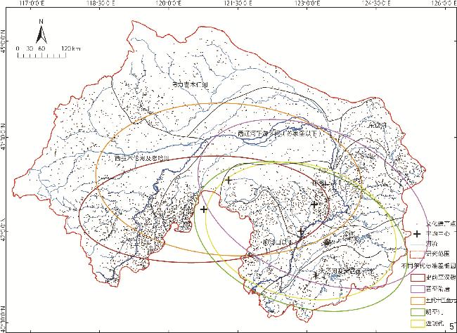
目的 辽河流域作为多民族交汇与农牧交错带的关键区域,其文化遗产的时空分布规律是理解中华民族共同体形成的重要线索。方法 整合11 151处文化遗产点的ArcGIS空间数据,构建辽河流域文化遗产数据库;采用历史文献考证、核密度分析、标准差椭圆分析与经纬度峰峦值分析的方法,通过全局空间自相关分析文化遗产点的时空分布特征,结合局部空间自相关方法解析局部集聚异质性,解析自然-人文因素对文化遗产时空演变的驱动机制。结果 1)辽河流域文化遗产分布整体呈现南密北疏形态,沿辽河干流及支流呈带状集聚,95%的文化遗产点集中于海拔<500 m、坡度<6°且距河流<7 km的区域;2)文化遗产分布中心由史前西辽河上游逐渐南迁至清代辽河平原;3)遗产点空间分布的适宜性演变整体呈自西向东、自北向南迁徙的趋势,东西两端逐渐向中部集中;4)遗产点时空分布的演变过程呈现聚集—散乱—集聚—极化4个阶段,与气候变化下各农牧民族的冲突、融合相关。结论 辽河流域文化遗产的动态适宜性演变为中华民族多元一体格局提供了流域尺度的物质证据,通过量化气候波动、政治扩张与民族互动的交互作用,揭示辽河流域文化遗产从被动适应到主动突破的演变机制,为流域尺度下多民族融合研究提供适宜的分析框架。
袁敬诚 , 李碧娇 , 仇思凡 . 辽河流域文化遗产地理空间格局及时空适宜性演变[J]. 风景园林, 2025 , 32(4) : 40 -49 . DOI: 10.3724/j.fjyl.LA20240155
Objective This research examines the spatiotemporal distribution, evolutionary mechanisms, and sustainability of cultural heritage in the Liao River Basin, located in Northeast Asia. The focus is on the transitional zone between nomadic and agrarian civilizations, with the aim to: 1) Explore the geographic selectivity of cultural heritage distribution under environmental constraints; 2) quantify phased transitions driven by the interactions between climatic and institutional factors; 3) identify spatial clustering anomalies linked to ecological fragility; 4) develop a framework for cultural heritage conservation in ethnic convergence corridors. The research investigates how geographical, climatic, and institutional factors have shaped heritage landscapes and reveals how the interactions between these factors inform modern conservation practices. Methods A geospatial database has been utilized, encompassing 11,151 heritage sites across six categories such as ancient ruins, tombs, and buildings, as well as five historical periods ranging from prehistoric period to modern period. The data are analyzed using spatial statistical techniques and historical mapping, with the primary methods being described as follows: spatiotemporal analysis employs standard deviation ellipses and kernel density estimation to analyze distribution and density ; spatial autocorrelation analysis utilizes Global Moran’s I and Local Moran’s I to assess spatial clustering and dispersion; environmental modeling incorporates elevation and slope buffers as well as DEM-derived landforms to assess the influence of natural geography on the spatial distribution of heritage sites; historical layering analysis focuses on policy maps to track how institutional changes and infrastructure development influence the distribution of heritage sites. Multivariate regression and path analysis are used to quantify the effects of climatic and institution on the heritage evolution . Results 1) Distribution determinants: The majority of heritage sites (95.2%) are located in optimal environmental conditions: elevation: below 500 m (mean value: 217.3±134.8 m); slope: less than 6° (84.7% ranging from 0° to 3°); distance to river: within 7 km. Buffer zone analysis reveals that 63.9% of heritage sites are concentrated in areas with an elevation of 200–400 m, a slope of 2–5°, and a distance to river of 3–5 km. Neolithic sites cluster along the Xiliao River Valley (42.5°N), with kernel density peaking at 2.8 sites/km², reflecting favorable conditions for millet agriculture and early settlements.2)Phased Transition: Cold-Dry Shift (post-
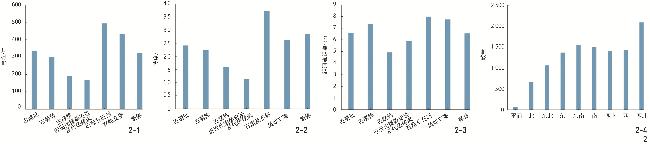
表1 不同历史时期不同类型文化遗产数量统计Tab. 1 Statistics of different types of cultural heritage during different historical periods |
| 历史时期 | 古遗址 | 古墓葬 | 古建筑 | 近现代重要史迹及代表性建筑 | 石窟寺及石刻 | 其他文物 | 总计 | 占比/% |
|---|---|---|---|---|---|---|---|---|
| 史前至汉魏 | 5 358 | 281 | 0 | 0 | 27 | 58 | 5 724 | 51.33 |
| 晋至隋唐 | 53 | 17 | 0 | 0 | 0 | 3 | 73 | 0.66 |
| 五代十国至元 | 3 128 | 726 | 25 | 0 | 19 | 52 | 3 950 | 35.42 |
| 明至清 | 633 | 112 | 124 | 113 | 42 | 18 | 1 042 | 9.34 |
| 近现代 | 0 | 0 | 4 | 349 | 6 | 3 | 362 | 3.25 |
| 总计 | 9 172 | 1 136 | 153 | 462 | 94 | 134 | 11 151 | 100.00 |
表2 全局莫兰指数统计量表及趋势特征Tab. 2 Statistical table and trend characteristics of Global Moran’ s I index |
| 历史时期 | 文化遗产点数量 | 全局莫兰指数 | z 值 | p 值 | 趋势特征 |
|---|---|---|---|---|---|
| 史前至汉魏 | 5 724 | 0.191 | 49.90 | 0.000 | 自然地理的主导聚集 |
| 晋至隋唐 | 73 | 0.021 | 5.57 | 0.000 | 战乱与治理的超离散化 |
| 五代十国至元 | 3 950 | 0.157 | 40.49 | 0.000 | 政权主导边疆开发集聚 |
| 明至清 | 1 042 | 0.163 | 47.14 | 0.000 | 政权主导边疆开发集聚 |
| 近现代 | 362 | 0.322 | 92.61 | 0.000 | 工业化与政策超强极化 |
| 整体 | 111 51 | 0.211 | 39.04 | 0.000 | 聚集—散乱—集聚—极化 |
| [1] |
汪芳, 李卓起, 董颖, 等. 从流域视角探讨文化遗产保护[J]. 建筑遗产, 2024(2):1-6.
WANG F, LI Z Q, DONG Y, et al. Cultural Heritage Conservation from the Perspective of River Basin[J]. Heritage Architecture, 2024(2):1-6.
|
| [2] |
MARTINO A, GERLA F, BALLETTI C, et al. Multi-scale and Multi-sensor Approaches for the Protection of Cultural Natural Heritage: The Island of Santo Spirito in Venice[J]. International Archives of the Photogrammetry, Remote Sensing and Spatial Information Sciences, 2023,XLVIII-M-2-2023: 1027-1034.
|
| [3] |
DEL B P. World Heritage for Building Peace[J]. Protection of Cultural Heritage, 2021, 12:141-147.
|
| [4] |
WANG X R, ZHANG T J, DUAN L R, et al. Spatial Distribution Characteristics and Influencing Factors of Intangible Cultural Heritage in the Yellow River Basin[J]. Journal of Cultural Heritage, 2024, 66:254-264.
|
| [5] |
DING N, ZHAI Y M, LYU H Y, et al. Crime Risk Analysis of Tangible Cultural Heritage in China from a Spatial Perspective[J]. ISPRS International Journal of Geo-Information, 2023, 12(5):201
|
| [6] |
KELMELIS S, WALDEN J P, GREEN MINK K, et al. Biocultural Taphonomies and Analysis of an Emerging Terminal Classic (750–900 CE) Maya Deathway[J]. Journal of Archaeological Method and Theory, 2025, 32:22
|
| [7] |
JIANG, H B, FENG G C, WANG Y X, et al. Land Subsidence in the Yangtze River Delta, China Explored Using InSAR Technique from 2019 to 2021[J]. IEEE Journal of Selected Topics in Applied Earth Observations and Remote Sensing, 2025, 18:4174-4187.
|
| [8] |
崔红茶, 陈新, 陈辞, 等. 长江流域少数民族特色村寨空间异质性及形成机理[J]. 经济地理, 2023, 43(9):160-171.
CUI H C, CHEN X, CHEN C, et al. Spatial Heterogeneity and Formation Mechanism of Ethnic Groups’ Villages in the Yangtze River Basin[J]. Economic Geography, 2023, 43(9):160-171.
|
| [9] |
吴映华夏, 谢守红, 毛华松. 国内外流域文化遗产保护研究进展与展望(2003—2022年)[J]. 西部人居环境学刊, 2023, 38(3):31-39.
WU Y H X, XIE S H, MAO H S. Research Progress and Prospect of River Basin Cultural Heritage Protection (2003−2022)[J]. Journal of Human Settlements in West China, 2023, 38(3):31-39.
|
| [10] |
薛鹏程, 徐浩义, 汪芳, 等. “人口—生产—生态”演化视角下流域聚落的适应性发展规划路径: 以黄河流域黄土高原地区为例[J]. 规划师, 2022, 38(11):41-49.
XUE P C, XU H Y, WANG F, et al. Adaptive Development Planning Paths of Settlements from the Perspective of “Population − production − Ecology” Evolution: An Example of the Loess Plateau Region of the Yellow River Basin[J]. Planners, 2022, 38(11):41-49.
|
| [11] |
赵烨, 赵怡钧, 刘心宇, 等. 生物文化遗产协同的汶水流域国土风景保护方法研究[J]. 西部人居环境学刊, 2023, 38(3):24-30.
ZHAO Y, ZHAO Y J, LIU X Y, et al. Biocultural Heritage Synergistic Approach to National Landscape Conservation in the Wenshui Watershed[J]. Journal of Human Settlements in West China, 2023, 38(3):24-30.
|
| [12] |
王剑利. “多廊联动”与多元一体的中国: 从辽西走廊的宗教实践切入[J]. 读书, 2021(9):3-13.
WANG J L. “Multiple Corridors Linkage” and a Multidimensional and Unified China: A Study of Religious Practices in the Liao Western Corridor[J]. Reading, 2021(9):3-13.
|
| [13] |
UNESCO. Space-Based Technologies for the Preservation of World Heritage Sites[EB/OL].(2023-09-12)[2025-2-27].https://whc.unesco.org/en/events/1764.
|
| [14] |
崔明德, 虎欣怡. 辽代汉人世家与契丹通婚研究[J]. 民族学论丛, 2024, 34(4):75-82.
CUI M D, HU X Y. A Study on the Intermarriage Between Han Family and Qidan in Liao Dynasty[J]. Journal of Hui Muslim Minority Studies, 2024, 34(4):75-82.
|
| [15] |
贾鑫, 张志平, 孙永刚, 等. 早全新世生境改善促进中国北方农牧交错带的农业起源[J]. 中国科学: 地球科学, 2024, 54(8):2574-2586.
JIA X, ZHANG Z P, SUN Y G, et al. Amelioration of Habitat Since the Early Holocene Contributed to the Origin of Agriculture in the Farming-Pastoral Zone of Northern China[J]. Scientia Sinica (Terrae), 2024, 54(8):2574-2586.
|
| [16] |
卓丰金, 李曌, 尚光霞, 等. 辽河流域大型底栖无脊椎动物环境压力耐受值确定研究[J/OL]. 水生态学杂志,1-17(2024-11-23)[2024-12-02]. https://doi.org/10.15928/j.1674-3075.202407120268.
ZHUO F J, LI Z, SHANG G X, et al. Research on the Determination of Environmental Pressure Tolerance Values of Large Benthic Invertebrates in the Liaohe River Basin[J/OL]. Journal of Aquatic Ecology,1-17(2024-11-23)[2024-12-02]. https://doi.org/10.15928/j.1674-3075.202407120268.
|
| [17] |
吴限. 辽河流域是玉龙故乡[N]. 辽宁日报,2023-01-06(8).
WU X. The Liaohe River Basin is the Hometown of Yulong[N]. Liaoning Daily,2023-01-06(8).
|
| [18] |
华玉冰. 辽河流域考古工作的重大社会政治贡献: 以辽西走廊为前沿与核心[J]. 渤海大学学报(哲学社会科学版), 2022, 44(6):10-14.
HUA Y B. Significant Contribution to Society and Politics Made by Archeological Work in Liaohe River Basin: Centered Around Liaoxi Corridor[J]. Journal of Bohai University (Philosophy & Social Science Edition), 2022, 44(6):10-14.
|
| [19] |
李霞, 张国壮, 陈永昊, 等. 农牧交错带辽河流域2010—2019年植被覆盖变化及驱动因素分析[J]. 农业工程学报, 2022, 38(22):63-72.
LI X, ZHANG G Z, CHEN Y H, et al. Vegetation Cover Change and Driving Factors in the Agro-pastoral Ecotone of Liaohe River Basin of China from 2010 to 2019[J]. Transactions of the Chinese Society of Agricultural Engineering, 2022, 38(22):63-72.
|
| [20] |
纳日碧力戈, 施展, 黄达远, 等. 边疆与中心的交互性: 铸牢中华民族共同体意识的走廊视角(笔谈)[J]. 西北民族研究, 2020(3):89-102.
Naribilige, SHI Z, HUANG D Y, et al. The Interaction Between the Borderland and Center: The Corridor Perspective of the Strong Sense of the Community for the Chinese Nation (Conversation by Writing)[J]. Northwestern Journal of Ethnology, 2020(3):89-102.
|
| [21] |
国家文物局. 中国文物地图集: 辽宁分册(上)[M]. 西安: 西安地图出版社, 2009:100-210.
National Administration of Cultural Heritage. The Atlas of Cultural Relics in China: Liaoning Province Volume (Vol. 1)[M]. Xi’an: Xi’an Map Publishing House, 2009:100-210.
|
| [22] |
国家文物局. 中国文物地图集: 内蒙古自治区分册(下)[M]. 西安: 西安地图出版社, 2003:78-494.
National Administration of Cultural Heritage. The Atlas of Cultural Relics in China: Inner Mongolia Autonomous Region Volume (Vol. 2)[M]. Xi’an: Xi’an Map Publishing House, 2003:78-494.
|
| [23] |
国家文物局. 中国文物地图集:河北分册(下)[M]. 北京: 文物出版社, 2013:261-360.
National Cultural Heritage Administration. The Atlas of Cultural Relics in China: Hebei Province Volume (Vol. 2)[M]. Beijing: Cultural Relics Publishing House, 2013:261-360.
|
| [24] |
国家文物局. 中国文物地图集:吉林分册[M]. 北京: 中国地图出版社, 1993:77-188.
National Cultural Heritage Administration. The Atlas of Cultural Relics in China: Jilin Province Volume[M]. Beijing: China Map Publishing House, 1993:77-188.
|
| [25] |
|
| [26] |
王琳, 武虹, 贾鑫. 西辽河地区史前聚落的时空演变与生业模式和气候历史的相关性研究[J]. 地球科学进展, 2016, 31(11):1159-1171.
WANG L, WU H, JIA X. Study on the Temporal-Spatial Evolution of Prehistoric Settlements and Its Correlation with Subsistence Strategy and Climate History in the Western Liao River Area[J]. Advances in Earth Science, 2016, 31(11):1159-1171.
|
| [27] |
宋晋, 李波, 王泽, 等. 西辽河流域的夏家店下层文化聚落遗址[J]. 大众考古, 2022(11):57-64.
SONG J, LI B, WANG Z, et al. Xiajiadian Lower Cultural Settlement Site in West Liaohe River Basin[J]. Popular Archaeology, 2022(11):57-64.
|
| [28] |
韩茂莉, 刘宵泉, 方晨, 等. 全新世中期西辽河流域聚落选址与环境解读[J]. 地理学报, 2007, 62(12):1287-1298.
HAN M L, LIU X Q, FANG C, et al. The Explanation of the Selection of Settlement and Environment in the Western Liaohe River Valley During the Middle Holocene Epoch[J]. Acta Geographica Sinica, 2007, 62(12):1287-1298.
|
| [29] |
袁钰莹. 全新世中期西辽河流域聚落空间分布及成因[J]. 地理科学, 2018, 38(5):773-779.
YUAN Y Y. Characteristics and Genesis of Spatial Distribution of Settlements in the West Liaohe River Basin During the Mid-Holocene[J]. Scientia Geographica Sinica, 2018, 38(5):773-779.
|
| [30] |
YUAN Y Y. Cultural Evolution and Spatial-Temporal Distribution of Archaeological Sites from 9.5-2.3 ka BP in the Yan-Liao Region[J]. Journal of Geographical Sciences, 2019, 29(3):449-464.
|
| [31] |
张达轩, 戴沈汝, 崔银秋. 古基因组视角下的亚洲北部人群迁徙和演化机制[J]. 遗传, 2025, 47(1):34-45.
ZHANG D X, DAI S R, CUI Y Q. The Migration and Evolutionary Mechanisms of Northern Asian Populations from the Perspective of Ancient Genomics[J]. Hereditas (Beijing), 2025, 47(1):34-45.
|
| [32] |
万晓. 权力转移下崛起国对小国政策探因: 以隋唐时期的吐谷浑与高句丽为例[J]. 当代亚太, 2020(3):30-68.
WAN X. Policies of the Rising Power Towards Small States in Power Transition: The Cases of Tuyuhun and Goguryeo During the Turks vs. Sui − Tang Period[J]. Journal of Contemporary Asia-Pacific Studies, 2020(3):30-68.
|
| [33] |
何志玉. 明代卫所屯田制与贵州地方经济发展: 基于发展经济学的视角[J]. 贵州财经学院学报, 2011(1):107-110.
HE Z Y. Army’s Engagement in Farming of Ming Dynasty and Development of Guizhou Local Economy: Based on Development Economics[J]. Journal of Guizhou University of Finance and Economics, 2011(1):107-110.
|
| [34] |
任鑫帅, 崔建新. 辽金时期西辽河流域旱涝序列重建与特征分析[J]. 干旱区资源与环境, 2020, 34(12):167-172.
REN X S, CUI J X. Reconstruction and Characteristic Analysis of Drought and Flood Series in the Xiliao River Valley During the Liao − Jin Periods[J]. Journal of Arid Land Resources and Environment, 2020, 34(12):167-172.
|
| [35] |
姜维公, 张奚铭. 试论明代辽东防御体系的演变及特征[J]. 史学集刊, 2023(3):39-49.
JIANG W G, ZHANG X M. On the Evolution and Characteristics of Defense System in Liaodong in Ming Dynasty[J]. Collected Papers of History Studies, 2023(3):39-49.
|
| [36] |
燕红忠, 许晨. 晚清营口贸易的商业机能与市场网络[J]. 中国经济史研究, 2016(4):51-79.
YAN H Z, XU C. Business Function and Market Network of Yingkou Trade in Late Qing Dynasty[J]. Researches in Chinese Economic History, 2016(4):51-79.
|
| [37] |
宋薇薇, 王海. 论辽南地区汉代社会发展: 燕秦汉时期东北亚走廊系列研究之三[J]. 南都学坛, 2016, 36(5):7-13.
SONG W W, WANG H. On the Social Development in the Southern Region of Liaoning During the Han Dynasty: The Third Series Research on the Northeast Asia Corridor During Yan and Qin and Han Dynasties[J]. Academic Forum of Nandu, 2016, 36(5):7-13.
|
| [38] |
倪润安. 鲜卑金器的形制、制作与演变[J]. 故宫博物院院刊, 2024(1):4-20.
NI R A. A Review of Xianbei Goldware in Shape, Manufacture and Evolution in History[J]. Palace Museum Journal, 2024(1):4-20.
|
| [39] |
王文光, 李书豪. 唐朝“大一统”的空间叙事: 基于《新唐书·地理志》的研究[J]. 云南民族大学学报(哲学社会科学版), 2024, 41(2):129-137.
WANG W G, LI S H. The Spatial Narrative of the “Great Unification” of the Tang Dynasty: A Study Based on Section of Geography: The New Book of the Tang Dynasty[J]. Journal of Yunnan Minzu University (Philosophy and Social Sciences Edition), 2024, 41(2):129-137.
|
| [40] |
孟洋洋. 契丹“镇东海口长城”位置新探[J]. 中国历史地理论丛, 2024, 39(3):132-140.
MENG Y Y. Location of the Great Wall of Zhendong Haikou at the Beginning of the Khitan Regime[J]. Journal of Chinese Historical Geography, 2024, 39(3):132-140.
|
| [41] |
张柏忠. 北魏至金代科尔沁沙地的变迁[J]. 中国沙漠, 1991, 11(1):36-43.
ZHANG B Z. Vicissitudes of Korqin Sandy Land from Northern Wei to Jing Dynasties[J]. Journal of Desert Research, 1991, 11(1):36-43.
|
| [42] |
王晓, 陈飞, 张静, 等. 气候、沙漠化与中国历史朝代的兴衰[J]. 人类生态学, 2010, 38(1):157-172.
WANG X, CHEN F, ZHANG J, et al. Climate, Desertification, and the Rise and Collapse of China’s Historical Dynasties[J]. Human Ecology, 2010, 38(1):157-172.
|
| [43] |
刘莉. 近代交通发展与社会生态变迁: 以东北地区为例[J]. 浙江学刊, 2022(6):217-227.
LIU L. Modern Transportation Development and Social-Ecological Changes: Take Northeast China as an Example[J]. Zhejiang Academic Journal, 2022(6):217-227.
|
| [44] |
侯峻, 曲晓璠. 近代辽河航运与沿岸城镇的兴起[J]. 社会科学战线, 1998(6):184-190.
HOU J, QU X F. Modern Liaohe Shipping and the Rise of Coastal Towns[J]. Social Science Front, 1998(6):184-190.
|
| [45] |
常学礼, 鲁春霞, 高玉葆. 人类经济活动对科尔沁沙地风沙环境的影响[J]. 资源科学, 2003, 25(5):78-83.
CHANG X L, LU C X, GAO Y B. Impacts of Human Economic Activities on Wind and Sand Environment in Kerqin Sandy Land[J]. Resources Science, 2003, 25(5):78-83.
|
/
| 〈 |
|
〉 |


