
地名学视野下滇池流域聚落空间格局及其演化特征
|
王迎澳/女/云南师范大学地理学部在读硕士研究生/研究方向为聚落地理 |
|
胡维建/男/云南师范大学地理学部在读硕士研究生/研究方向为人居环境治理 |
|
彭文/男/云南师范大学地理学部硕士研究生/研究方向为聚落地理 |
|
杨宇亮/男/白族/博士/云南师范大学地理学部教授/研究方向为聚落地理与城乡规划 |
Copy editor: 李清清
收稿日期: 2024-09-16
修回日期: 2025-02-26
网络出版日期: 2025-12-14
基金资助
国家自然科学基金“国土空间视野下纵向岭谷区村落人居环境优化的空间肌理与方法”(52168012)
版权
Spatial Pattern and Evolutionary Characteristics of Settlements in Dianchi River Basin from the Perspective of Toponymy
|
WANG Ying’ao is a master student in the School of Geography, Yunnan Normal University. Her research focuses on settlement geography |
|
HU Weijian is a master student in the School of Geography, Yunnan Normal University. His research focuses on governance of human settlement environment |
|
PENG Wen is a Master graduate in the School of Geography, Yunnan Normal University.His research focuses on settlement geography |
|
YANG Yuliang (Bai), Ph.D., is a professor in the School of Geography, Yunnan Normal University. His research focuses on settlement geography and urban and rural planning |
Received date: 2024-09-16
Revised date: 2025-02-26
Online published: 2025-12-14
Copyright
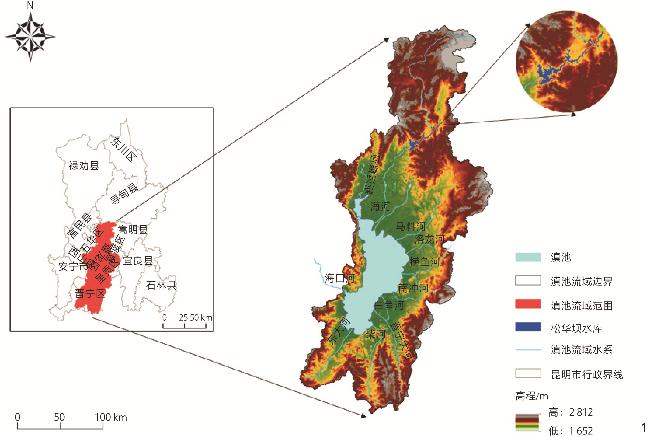
目的 通过构建地名语义与空间属性框架,分析滇池流域聚落的空间格局,揭示“人水关系”驱动下的聚落形成机制。方法 以
王迎澳 , 胡维建 , 彭文 , 杨宇亮 . 地名学视野下滇池流域聚落空间格局及其演化特征[J]. 风景园林, 2025 , 32(4) : 50 -59 . DOI: 10.3724/j.fjyl.202409160547
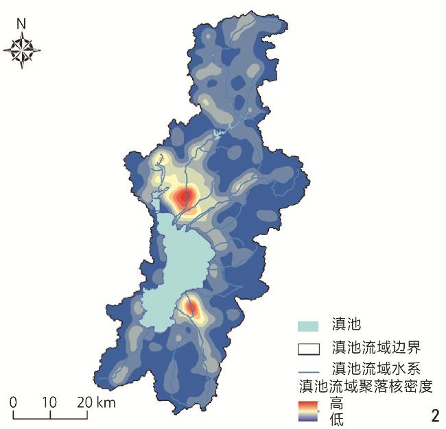
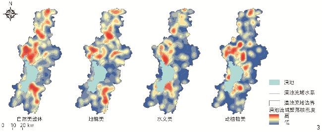
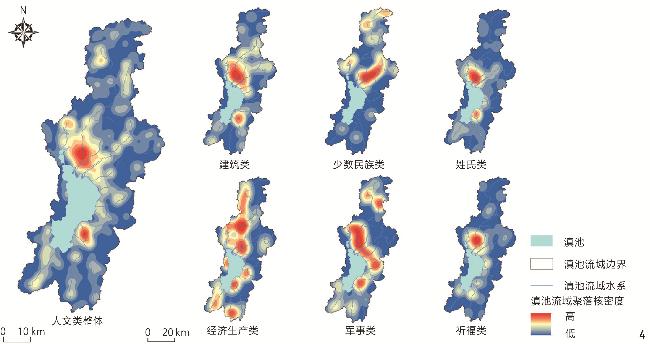
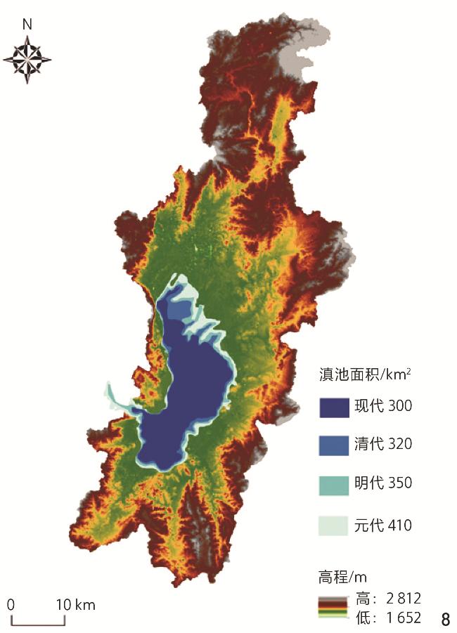
Objective The Dianchi Lake Basin is a typical sample of plateau lake-type human – water interaction, and its settlement system evolution contains the spatial code of human settlements adapting to hydrological changes. Through integrating the spatio-temporal analysis of topography and geospatial analysis, this research reveals the formation mechanism of settlement pattern driven by human – water relationship, explores the evolution characteristics of settlement pattern in the Dianchi Lake Basin, and provides methodological innovation for interdisciplinary research of human settlement environment science. Methods 1,332 toponyms of historical settlements are selected as the research objects, and the nature – human binary semantic analysis framework is constructed by using the method of geographical language analysis. In order to explore the spatial distribution types of toponymic settlements, the closest proximity index and geographical concentration index are used for analysis. In order to further reflect the agglomeration distribution law of settlements, the distribution location and law of settlements are analyzed by nuclear density analysis. In addition, the buffer zone analysis method is used to further explore the spatial correlation between settlement distribution and hydrological characteristics, and the geographical detector is used to carry out relevant research to explore the spatial mechanism with respect to the impact of geographical factors on toponym pattern. Toponyms in the Dianchi Lake Basin are formed in the interaction process of human – water relationship. The research on natural toponyms reveals that geomorphic environment and hydrological environment are the basis of human settlement activities. Seven indexes are selected to construct the index system of driving factors for the spatial pattern of settlement, with factor detection and interaction detection being adopted for specific analysis. Through the historical geographic information corroboration, the research reveals the change law of human settlement environment at a 1,000-year scale. Results 1) The settlements in the Dianchi Lake Basin as a whole and all kinds of toponyms are clustered; the distribution of settlements shows a “two-center” structure with obvious water system agglomeration characteristics, revealing the process of shifting the focus of human settlement activities under the trend of “water retreating and people advancing”, which is realized through the major events of “human – water relationship” such as the cultivation of farmland by the Institute of Sanitation, the construction of water conservancy, and the expansion of irrigation areas. The north alluvial fan area relies on the Panlong River system to form the administrative and economic complex center, while the southeast lakeside plain retains the characteristics of early fishing and farming civilization, forming the geographical differentiation law of “south fishing and north farming”. The center of gravity of human settlement activities has shifted from the southeast bank to the north bank, and the benign control of hydrological environment has been realized in the gradual cumulation human settlement behavior. 2) The interactive effect of elevation and river network density is the key factor leading the evolution of settlement pattern in the Dianchi Lake Basin: In short-term scale, elevation and river network density are interlocking, and the hydraulic engineering reduces the riverbed elevation and expands the alluvial fan area, which significantly enhances the settlement carrying capacity in the low altitude area and affects the spatial pattern of settlement after Yuan Dynasty; in the long term, from the dual clues of “hydrological constraint” to human – water interaction, the significant spatial coupling of the migration trajectory of the settlement center of gravity and the retreat process of the lake shoreline confirms the characteristics of the phased transformation of the relationship between human and water, and realizes the paradigm shift from “choosing to live near water” to “controlling water for better habitation”. Conclusion The combination of toponymy and spatial analysis provides an innovative path for the interdisciplinary research on human settlement science. By constructing a coupling analysis framework of toponym semantics and spatial attributes, this research confirms the “spatio-temporal code” function of toponym in the process reconstruction of human settlements, and the capability to analyze multi-source heterogeneous data based on the aforesaid function provides a new analytical methodology for the research on watershed human settlements. The changing vein of human settlement environment with human – water relationship as the main line continues to this day. At present, the Dianchi Lake Basin is the key area of Kunming’s urban planning and construction, and the planning measures to strengthen the ecological barriers of rivers and lakes are of great importance to the ecological security pattern of human settlements in the Dianchi Lake Basin. At the same time, as a reflection of folk style and deep historical and cultural heritage, toponyms contain the relationship between man and nature in different stages. Therefore, in urban construction, the search of traditional toponyms, the mining of cultural connotations toponyms, and the reasonable naming of new toponyms are not only conducive to the protection of the intangible cultural heritage of traditional toponyms, but also play an important role in following the law of urban development and realizing the harmonious relationship between people and water.
表1 滇池流域聚落地名用字分类Tab. 1 Classification of words used in settlement toponyms in the Dianchi Lake Basin |
| 主类 | 亚类 | 主要用字 | 总数/个 | 比例/% |
|---|---|---|---|---|
| 自然类 | 地貌 | 山、冲、洞、坡、坝、箐、石、凹、甸、口、咀、峰 | 358 | 26.88 |
| 水文 | 塘、河、沟、湾、海、潭、水、埂、溪、江、泉、源 | 247 | 18.54 | |
| 动植物 | 龙、马、羊、树、花、桃、竹、梨、谷、牛、杨 | 181 | 13.59 | |
| 人文类 | 姓氏 | 李、杨、王、张、罗、陈、苏、赵、余、高、马、周 | 149 | 11.19 |
| 军事 | 营、哨、屯、卫、寨、甲、所、关、堡、站 | 136 | 10.21 | |
| 建筑 | 桥、寺、坟、城、房、庙、井、院、牌、门、楼、庵 | 100 | 7.51 | |
| 祈福 | 兴、乐、平、福、丰、和、永、富、旺、善 | 60 | 4.50 | |
| 经济生产 | 街、铺、窑、厂、渡、店、仓、坊 | 51 | 3.83 | |
| 少数民族 | 普、鲁、白、妥、瓦、亩、郎、黑、母、纳、达 | 50 | 3.75 |
表2 滇池流域各类聚落空间分布特征计算值Tab. 2 Calculated values of spatial distribution characteristics of various settlements in the Dianchi Lake Basin |
| 地名类别 | R值 | p值 | z值 | G值 | G0值 |
|---|---|---|---|---|---|
| 自然类 | 0.728 | 0.000 | -14.592 | 41.020 | 37.797 |
| 地貌类 | 0.746 | 0.000 | -9.191 | 41.307 | 37.797 |
| 水文类 | 0.673 | 0.000 | -9.844 | 42.495 | 37.800 |
| 动植物类 | 0.705 | 0.000 | -7.605 | 39.32 | 37.800 |
| 人文类 | 0.569 | 0.000 | -19.234 | 42.088 | 37.797 |
| 姓氏类 | 0.611 | 0.000 | -9.049 | 47.365 | 37.802 |
| 军事类 | 0.589 | 0.000 | -9.164 | 42.086 | 37.809 |
| 建筑类 | 0.691 | 0.000 | -5.906 | 42.895 | 37.815 |
| 祈福类 | 0.884 | 0.085 | -1.721 | 46.068 | 37.859 |
| 经济生产类 | 0.735 | 0.000 | -3.623 | 42.554 | 37.869 |
| 少数民族类 | 0.627 | 0.000 | -5.052 | 58.788 | 37.841 |
| 整体 | 0.715 | 0.000 | -19.913 | 40.736 | 37.797 |
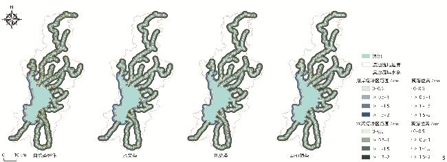
图5 自然类地名聚落在水系缓冲区中的分布Fig. 5 Distribution of natural toponymic settlements in the river system buffer zone |
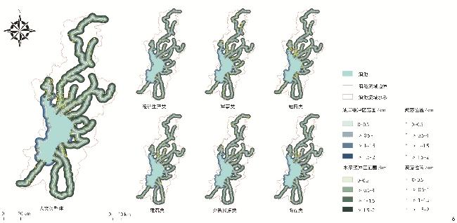
图6 人文类地名聚落在水系缓冲区中的分布Fig. 6 Distribution of humanistic toponymic settlements in the river system buffer zone |
表3 滇池流域水系缓冲区中各类聚落数量Tab. 3 Number of various types of settlements in the river system buffer zone of the Dianchi Lake Basin |
| 缓冲区范围/km | 地貌类 | 水文类 | 动植物类 | 姓氏类 | 军事类 | 建筑类 | 祈福类 | 经济生产类 | 少数民族类 | |
|---|---|---|---|---|---|---|---|---|---|---|
| 支流缓冲区 | 0~0.5 | 80 | 58 | 38 | 57 | 43 | 29 | 15 | 17 | 29 |
| >0.5~1 | 44 | 32 | 32 | 23 | 40 | 17 | 11 | 8 | 9 | |
| >1~1.5 | 47 | 27 | 24 | 23 | 25 | 16 | 11 | 7 | 8 | |
| >1.5~2 | 27 | 34 | 20 | 12 | 6 | 13 | 9 | 4 | 4 | |
| 湖岸缓冲区 | 0~0.5 | 10 | 29 | 9 | 13 | 1 | 1 | 4 | 4 | 0 |
| >0.5~1 | 10 | 15 | 6 | 4 | 2 | 0 | 6 | 1 | 0 | |
| >1~1.5 | 6 | 6 | 5 | 1 | 1 | 3 | 2 | 3 | 1 | |
| >1.5~2 | 11 | 7 | 9 | 57 | 1 | 2 | 2 | 1 | 0 | |
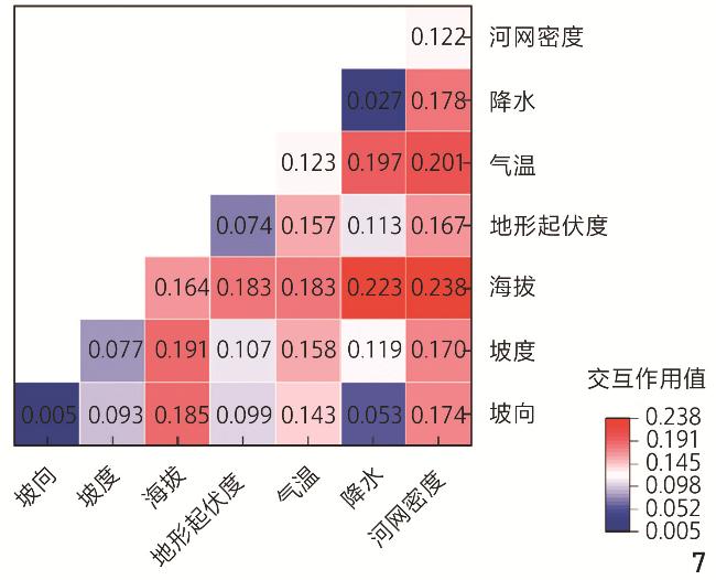
表4 因子探测结果Tab. 4 Factor detection results |
| 地名类别 | 影响因子 | ||||||
|---|---|---|---|---|---|---|---|
| 坡向(X1) | 坡度(X2) | 海拔(X3) | 地形起伏度 (X4) | 年平均气温 (X5) | 年平均降水量 (X6) | 河网密度 (X7) | |
| 整体地名(Y1) | 0.005* | 0.077** | 0.164** | 0.074** | 0.123** | 0.027** | 0.122** |
| 自然类(Y2) | 0.004 | 0.003 | 0.053** | 0.020 | 0.038** | 0.010 | 0.054** |
| 水文类(Y3) | 0.005 | 0.035 | 0.043** | 0.034 | 0.029** | 0.020* | 0.040** |
| 地貌类(Y4) | 0.007 | 0.001 | 0.009 | 0.031** | 0.013 | 0.030** | 0.021* |
| 动植物类(Y5) | 0.003 | 0.014 | 0.034** | 0.020 | 0.028** | 0.004 | 0.020* |
| 人文类(Y6) | 0.004 | 0.068** | 0.153** | 0.085** | 0.126** | 0.035** | 0.089** |
| 经济生产类(Y7) | 0.005 | 0.022 | 0.012 | 0.012 | 0.016* | 0.002 | 0.002 |
| 少数民族类(Y8) | 0.007 | 0.001 | 0.004 | 0.002 | 0.018* | 0.028** | 0.025** |
| 姓氏类(Y9) | 0.007 | 0.037** | 0.074** | 0.047** | 0.053** | 0.020* | 0.035** |
| 祈福类(Y10) | 0.003 | 0.017* | 0.046** | 0.018* | 0.035** | 0.020* | 0.027** |
| 军事类(Y11) | 0.003 | 0.019** | 0.044** | 0.028** | 0.046** | 0.009 | 0.052 |
| 建筑类(Y12) | 0.002 | 0.016* | 0.059** | 0.031** | 0.039** | 0.030** | 0.021* |
文中图表均由作者绘制,其中
| [1] |
汪芳, 刘永, 贺金生, 等. 流域人居系统科学的框架探索与研究展望[J]. 自然资源学报, 2024, 39(5):997-1007.
WANG F, LIU Y, HE J S, et al. River Basin Habitats Science: Framework and Prospects[J]. Journal of Natural Resources, 2024, 39(5):997-1007.
|
| [2] |
田阡. 流域人类学导论[M]. 北京: 人民出版社, 2018.
TIAN Q. Introduction to Watershed Anthropology[M]. Beijing: People’s Education Press, 2018.
|
| [3] |
左其亭. 人水关系学的学科体系及发展布局[J]. 水资源与水工程学报, 2021, 32(3):1-5.
ZUO Q T. Discipline System of Human-Water Relationship and Its Development Layout[J]. Journal of Water Resources and Water Engineering, 2021, 32(3):1-5.
|
| [4] |
李倩文, 左其亭, 李东林, 等. 新疆水资源开发利用的空间均衡分析[J]. 水资源保护, 2021, 37(2):28-33.
LI Q W, ZUO Q T, LI D L, et al. Spatial Equilibrium Analysis of Water Resources Development and Utilization in Xinjiang[J]. Water Resources Protection, 2021, 37(2):28-33.
|
| [5] |
胡春宏. 黄河水沙变化与治理方略研究[J]. 水力发电学报, 2016, 35(10):1-11.
HU C H. Changes in Runoff and Sediment Loads of the Yellow River and Its Management Strategies[J]. Journal of Hydroelectric Engineering, 2016, 35(10):1-11.
|
| [6] |
闫宝伟, 郭生练, 余维. 长江和清江洪水过程遭遇风险分析[J]. 水力发电学报, 2013, 32(1):50-53.
YAN B W, GUO S L, YU W. Coincidence Risk of Flood Hydrographs Between Yangtze River and Qing River[J]. Journal of Hydroelectric Engineering, 2013, 32(1):50-53.
|
| [7] |
张盛文. 关于人水关系的哲学思考[J]. 水利发展研究, 2012, 12(2):89-93.
ZHANG S W. Philosophical Thinking on the Relationship Between Man and Water[J]. Water Resources Development Research, 2012, 12(2):89-93.
|
| [8] |
冯燕. 坎儿井功能衰退: 干旱区人水关系的演变[J]. 中国农业大学学报(社会科学版), 2019, 36(2):59-67.
FENG Y. The Functional Decline of Karez: Evolution of Human-Water Relationship in Arid Areas[J]. China Agricultural University Journal of Social Sciences Edition, 2019, 36(2):59-67.
|
| [9] |
谢诗娴, 郭巍, 张清然. 桑园围水适应性研究: 整体性、差异性和联动性[J]. 城市规划, 2023, 47(8):87-100.
XIE S X, GUO W, ZHANG Q R. Research on Water Adaptability of Sangyuanwei Polder Embankment System: Integrity, Difference, and Linkage[J]. City Planning Review, 2023, 47(8):87-100.
|
| [10] |
刘灵坪. 16—20世纪滇池流域的乡村聚落与人地关系: 以柴河三角洲为例[J]. 中国历史地理论丛, 2012, 27(1):37-46.
LIU L P. A Study on the Historical Rural Settlements and the Man-Land Relationship in Dianchi Basin from 16th to 20th Century: A Case of Chai River Delta Plain[J]. Journal of Chinese Historical Geography, 2012, 27(1):37-46.
|
| [11] |
王涛, 李君, 陈长瑶, 等. 高原湖泊平坝区乡村“涉水”地名文化景观分析: 以环滇池地区为例[J]. 经济地理, 2020, 40(12):231-239.
WANG T, LI J, CHEN C Y, et al. Cultural Landscape of Village Toponym Named After the Element of Water in Plain Region of Plateau Lake: A Case Study of the Dianchi Lake Region[J]. Economic Geography, 2020, 40(12):231-239.
|
| [12] |
金杰, 张洪. 生态约束下的城市用地扩张与土地集约利用模式: 以滇池流域为例[J]. 城市发展研究, 2014, 21(2):42-48.
JIN J, ZHANG H. Ecological Constraints of Urban Sprawl and Land Intensive Use Model: A Case Study of Dianchi River[J]. Urban Development Studies, 2014, 21(2):42-48.
|
| [13] |
余中元, 李波. 滇池流域生态经济系统特征与区域协调发展土地利用模式研究[J]. 农业现代化研究, 2013, 34(4):456-460.
YU Z Y, LI B. Characteristics of Ecological Economic System and Land Use Pattern for Regional Coordinated Development of the Dianchi Lake Watershed[J]. Research of Agricultural Modernization, 2013, 34(4):456-460.
|
| [14] |
尹露曦. 云南滇池地区传统地域景观研究[D]. 北京: 北京林业大学, 2021.
YIN L X. Study on Traditional Regional Landscape in Dianchi Lake Area of Yunnan Province[D]. Beijing: Beijing Forestry University, 2021.
|
| [15] |
王晞月. 中国古代陂塘系统及其与城市的关系研究[D]. 北京: 北京林业大学, 2019.
WANG X Y. The Impounding Lake System of China and Its Relationship with Ancient City[D]. Beijing: Beijing Forestry University, 2019.
|
| [16] |
牛汝辰. 地名学有什么用[J]. 中国地名, 2016(4):10-13.
NIU R C. What’s the Use of Toponymy[J]. China Place Name, 2016(4):10-13.
|
| [17] |
ASSMANN J, CZAPLICKA J. Collective Memory and Cultural Identity[J]. New German Critique, 1995(65):125
|
| [18] |
陈晨, 程林. 关中平原历史地名演变中的文化政治格局: 基于批判地名学的研究[J]. 人文地理, 2020, 35(6):50-56.
CHEN C, CHENG L. The Culture and Politics During the Evolution of Historical Place: Names in Kuan-Chung Plain in the Perspective of Critical Toponymy[J]. Human Geography, 2020, 35(6):50-56.
|
| [19] |
杨冉冉, 高梦洋, 王洪波, 等. 文化生态视角下清代以来围场地名景观演变[J]. 干旱区资源与环境, 2023, 37(8):169-177.
YANG R R, GAO M Y, WANG H B, et al. Evolution of Weichang Placename Landscape Since Qing Dynasty from the Perspective of Cultural Ecology[J]. Journal of Arid Land Resources and Environment, 2023, 37(8):169-177.
|
| [20] |
陈庆江. 试论古代云南政区地名的第一次大变迁[J]. 云南大学学报(社会科学版), 2018, 17(5):61-65.
CHEN Q J. On the First Major Change in the Geographical Names of Administrative Districts in Ancient Yunnan[J]. Journal of Yunnan University (Social Sciences Edition), 2018, 17(5):61-65.
|
| [21] |
吴光范. 彝语地名学初探[J]. 云南社会科学, 2000(6):1-12.
WU G F. A Preliminary Study on the Toponymy of Yi Nationality[J]. Social Sciences in Yunnan, 2000(6):1-12.
|
| [22] |
吴光范. 昆明古今地名考释[M]. 昆明: 云南人民出版社, 2006.
WU G F. The Evolution of Kunming's Place Names: From Antiquity to the Present[M]. Kunming: Yunnan People’s Publishing House, 2006.
|
| [23] |
王法辉, 王冠雄, 李小娟. 广西壮语地名分布与演化的GIS分析[J]. 地理研究, 2013, 32(3):487-496.
WANG F H, WANG G X, LI X J. GIS-Based Spatial Analysis of Zhuang Place Names in Guangxi, China[J]. Geographical Research, 2013, 32(3):487-496.
|
| [24] |
张堃, 王培茗, 李诗睿. 基于历史地名法的1642—1980年鲁甸县乡村聚落空间演变特征研究[J]. 工业建筑, 2023, 53 S1):61-65.
ZHANG K, WANG P M, LI S R. Spatial Evolution and Characteristics of Rural Settlements in Ludian County (1642−1980): A Historical Toponymic Approach[J]. Industrial Construction, 2023, 53(S1):61-65.
|
| [25] |
宋全成. 地名发展、移民变迁与乡愁记忆传承: 基于山东省自然村地名普查数据的实证分析[J]. 山东师范大学学报(社会科学版), 2020, 65(4):143-156.
SONG Q C. Development of Place Names, Immigration Change and Nostalgic Memory Inheritance: Empirical Analysis Based on the Census Data of Place Names of Natural Villages in Shandong Province[J]. Journal of Shandong Normal University (Social Sciences), 2020, 65(4):143-156.
|
| [26] |
刘玉堂, 李艳琼. 文化语言学视域下地名文化遗产的研究、保护与开发[J]. 理论月刊, 2023(1):90-102.
LIU Y T, LI Y Q. Research, Protection and Development of the Cultural Heritage of Place Names from the Perspective of Cultural Linguistics[J]. Theory Monthly, 2023(1):90-102.
|
| [27] |
昆明市滇池管理局, 昆明滇池研究会. 滇池志[M]. 昆明: 云南美术出版社, 2019.
Kunming City Dianchi Lake Administration, Kunming Dianchi Lake Research Society. Dianchi Lake Chronicles[M]. Kunming: Yunnan Art Publishing House, 2019.
|
| [28] |
彭文, 杨宇亮, 黄雅飞, 等. 云南省佛教寺院空间分异特征及影响因素[J]. 热带地理, 2024, 44(2):315-325.
PENG W, YANG Y L, HUANG Y F, et al. Spatial Differentiation Characteristics and Influencing Factors of Buddhist Monasteries in Yunnan Province[J]. Tropical Geography, 2024, 44(2):315-325.
|
| [29] |
唐英, 吴静雯, 张佑铭, 等. 陕北传统村落空间分布特征及其影响因素[J]. 水土保持研究, 2023, 30(6):396-405.
TANG Y, WU J W, ZHANG Y M, et al. Spatial Distribution Characteristics and Influencing Factors of the Traditional Villages in Northern Shaanxi[J]. Research of Soil and Water Conservation, 2023, 30(6):396-405.
|
| [30] |
戴忱. ArcGIS缓冲区分析支持下的城市规划用地布局环境适宜性分析[J]. 现代城市研究, 2013, 28(10):22-28.
DAI C. The Urban Planning Land Layout Environmental Suitability Analysis Supported by ArcGIS Buffer Analysis[J]. Modern Urban Research, 2013, 28(10):22-28.
|
| [31] |
王劲峰, 徐成东. 地理探测器: 原理与展望[J]. 地理学报, 2017, 72(1):116-134.
WANG J F, XU C D. Geodetector: Principle and Prospective[J]. Acta Geographica Sinica, 2017, 72(1):116-134.
|
| [32] |
马仁锋, 陈佳锐. 长三角地区地名通名文化景观空间格局及影响因素[J]. 地理研究, 2022, 41(3):764-776.
MA R F, CHEN J R. The Spatial Pattern and Influencing Factors of the Cultural Landscape of Generic Place Names in the Yangtze River Delta[J]. Geographical Research, 2022, 41(3):764-776.
|
| [33] |
ZHANG Y H, LU H P, QU W C. Geographical Detection of Traffic Accidents Spatial Stratified Heterogeneity and Influence Factors[J]. International Journal of Environmental Research and Public Health, 2020, 17(2):572
|
| [34] |
李俊甫, 房阿曼, 吴克宁, 等. 河南省耕地“非粮化” 空间分异特征及其驱动因素分析[J]. 中国农业资源与区划, 2024, 45(11):23-34.
LI J F, PANG A M, WU K N, et al. Analysis of Spatial Differentiation Characteristics and Driving Factors of “Non-grain” Cultivated Land in Henan Province[J]. Chinese Journal of Agricultural Resources and Regional Planning, 2024, 45(11):23-34.
|
| [35] |
宋濂. 元史[M]. 北京: 中华书局, 1976.
SONG L. History of Yuan Dynasty[M]. Beijing: Zhonghua Book Company, 1976.
|
| [36] |
黄士杰. 云南省城六河图说[M].影印本. 台北: 成文出版社, 1974.
HUANG S J. Kunming's Six Rivers: An Illustrated Gazetteer[M].Photocopy. Taipei: Cheng Wen Publishing Co., Ltd., 1974.
|
| [37] |
陈晨, 修春亮, 陈伟, 等. 基于GIS的北京地名文化景观空间分布特征及其成因[J]. 地理科学, 2014, 34(4):420-429.
CHEN C, XIU C L, CHEN W, et al. Spatial Distribution Characteristics of Place-Name Landscape Based on GIS Approach in Beijing and Its Reasons for the Formation[J]. Scientia Geographica Sinica, 2014, 34(4):420-429.
|
| [38] |
孙冬虎. 京杭运河沿线地名文化遗产的形成轨迹[J]. 北京社会科学, 2023(3):35-44.
SUN D H. The Formation Track of the Cultural Heritage of Geographical Names Along the Beijing − Hangzhou Canal[J]. Social Sciences of Beijing, 2023(3):35-44.
|
| [39] |
陆韧, 马琦, 唐国莉. 历史时期滇池流域人地关系及生态环境演变研究[M]. 北京: 社会科学文献出版社, 2018.
LU R, MA Q, TANG G L. A Study of Man-Land Relationship and Environment Evolution of Dianchi Lake Basin in Historical Periods[M]. Beijing: Social Sciences Literature Publishing House, 2018.
|
/
| 〈 |
|
〉 |