
基于最小生成树算法的中国传统村落集聚特征识别与区划
|
石炀/男/博士/北京建筑大学科学技术发展研究院副院长、副教授/研究方向为历史城市保护更新、传统村落保护发展 |
|
郭虹卉/女/北京建筑大学建筑与城市规划学院在读硕士研究生/研究方向为城乡发展历史与遗产保护规划 |
|
马萧萧/男/北京建筑大学建筑与城市规划学院在读硕士研究生/研究方向为城乡发展历史与遗产保护规划 |
|
凡来/女/博士/北京建筑大学建筑与城市规划学院在站博士后、讲师/研究方向为建筑遗产保护 |
Copy editor: 李清清
收稿日期: 2025-04-15
修回日期: 2025-09-17
网络出版日期: 2025-12-10
基金资助
国家自然科学基金“山地传统聚落洪涝适灾机理解析与应用研究”(52478039)
国家自然科学基金“基于传统营建智慧的京冀太行山区乡村聚落洪涝适灾能力提升研究”(52508002)
国家重点研发计划子课题“国土空间文物资源保护利用信息感知、规划编制与管控传导技术集成”(2023YFC3803905-2)
版权
Identification and Regionalization of the Agglomeration Characteristics of Traditional Chinese Villages Based on the Minimum Spanning Tree Algorithm
|
SHI Yang, Ph.D., is an associate professor and deputy director of the Research Institute of Science and Technology Development, Beijing University of Civil Engineering and Architecture. His research focuses on conservation and regeneration of historical cities, and conservation and development of traditional villages |
|
GUO Honghui is a master student in the School of Architecture and Urban Planning, Beijing University of Civil Engineering and Architecture. Her research focuses on urban-rural development history and heritage conservation planning. |
|
MA Xiaoxiao is a master student in the School of Architecture and Urban Planning, Beijing University of Civil Engineering and Architecture. His research focuses on urban-rural development history and heritage conservation planning |
|
FAN Lai, Ph.D., is a postdoctoral researcher and lecturer in the School of Architecture and Urban Planning, Beijing University of Civil Engineering and Architecture. Her research focuses on architectural heritage conservation |
Received date: 2025-04-15
Revised date: 2025-09-17
Online published: 2025-12-10
Copyright
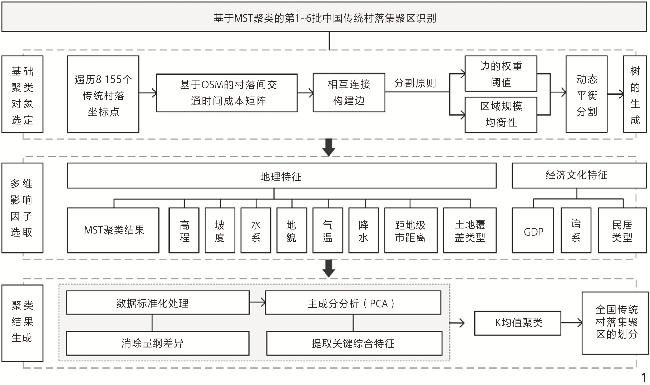
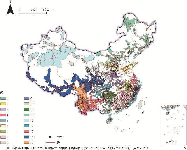
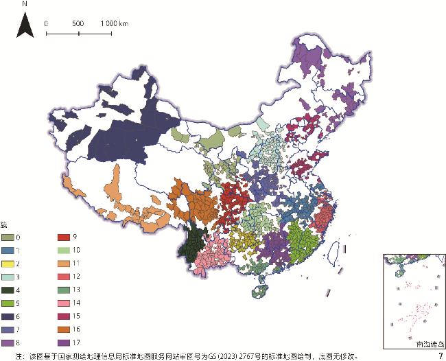
【目的】本研究旨在通过空间网络分析、主成分分析(principal component analysis, PCA)、K均值聚类算法,量化第1~6批中国传统村落分布的地理文化特征,构建全国尺度的传统村落集聚区划分模型,并提出差异化保护策略,为政策制定提供理论支撑。【方法】基于国家第1~6批传统村落名录,运用地理信息系统(geographic information system, GIS)中的叠加分析模型,揭示中国传统村落的空间分布特征,在进行中国传统村落集聚区划分方法的思路构建时,优先考虑以交通时间成本为权重构建基于图论优化的最小生成树(minimum spanning tree, MST),实现对中国传统村落集聚区的初步划分,构建涵盖地理、经济、文化要素的多维度特征谱系,对相关影响因子进行降维处理与主成分提取,通过K均值聚类算法实现多维特征分类,划定集聚区。【结果】发现中国传统村落具有较为明显的聚类特征,并识别出18个传统村落集聚区。【结论】通过兼顾地理空间基底与非空间特征聚类模型的构建,优化了传统的空间聚类方法。通过“交通廊道骨架—文化特征谱系—空间响应阈值”的技术框架,实现了对中国传统村落物质空间效率与文化基因传承的耦合解析,为传统建筑技艺活态传承与地域文化基因延续注入持续动力。
石炀 , 郭虹卉 , 马萧萧 , 凡来 . 基于最小生成树算法的中国传统村落集聚特征识别与区划[J]. 风景园林, 2025 , 32(11) : 21 -30 . DOI: 10.3724/j.fjyl.LA20250240
[Objective] This research aims to quantify the geocultural characteristics of Chinese traditional villages through spatial network analysis, principal component analysis (PCA), and clustering algorithms. By constructing a national-scale agglomeration demarcation model, this research proposes differentiated conservation strategies to optimize conservation area delineation methods considering natural geography, historical culture, and socioeconomic dimensions. The research ultimately provides theoretical foundations for policy-making to balance heritage preservation with regional development dynamics.
[Methods] The research method adopted in this research is to combine graph theory and machine learning with data from the lists of six batches of traditional villages published by the Ministry of Housing and Urban-Rural Development of the People’s Republic of China and other departments. First, the minimum Spanning tree (MST) model weighted by the actual transportation time cost is adopted to carry out the preliminary clustering. This process quantifies the spatial connection strength between villages by prioritizing the selection of low-cost connections and cutting off high-cost connections, and ultimately forms a spatial structure that highlights transportation accessibility and spatial proximity. Then, through Principal Component analysis (PCA) and K-Means clustering methods, the multi-dimensional cultural and geographical characteristics are analyzed. The analysis objects not only include the clustering results obtained based on the MST method, but also cover natural and cultural elements. On this basis, this research constructs a characteristic spectrum based on the geographical, economic and cultural characteristics of traditional villages, and divides the villages into different agglomeration areas according to their natural geographical attributes and cultural attributes. And through the spatial superposition analysis method, the K-Means clustering method are observed to explore the cultural background, language system characteristics, environmental characteristics and architectural types involved in each zoning.
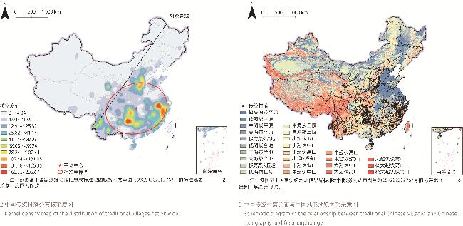
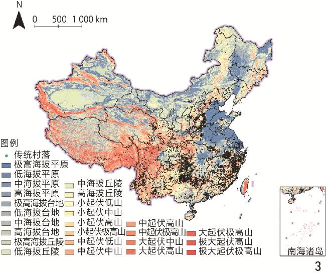
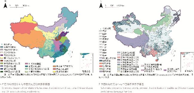
[Results] The MST and K-Means clustering results are respectively spatially superimposed and analyzed with the current situation of provincial administrative divisions across the country. The results show that the MST clustering boundaries based on transportation cost weighting are highly coexisting with the provincial administrative boundaries in provinces with dense traditional villages. This phenomenon stems from the characteristics of the MST method. The network construction principle of MST, which aims to minimize the overall transportation cost, makes it easier to form continuous clusters overlapping with administrative boundaries in areas with high density of traditional villages and strong transportation accessibility. Administrative boundaries are often delineated relying on geographical barriers such as rivers and mountains, and these barriers can lead to a significant increase in transportation costs, which is corresponding to the segmentation logic of MST that removes high-cost edges. In contrast, the K-Means clustering boundaries based on the MST clustering results and combined with the main components of natural and cultural elements such as topography, mountain and river aggregation, climate, and language system have a relatively high consistency with the provincial administrative boundaries in provinces with scattered traditional villages. The distribution of traditional villages in these provinces shows the characteristics of "broad geographical space" and overall “great dispersion”. The geographical and economic and cultural characteristics extracted by the PCA method show a spatial polarization of “small clusters”. In provinces with a high concentration of traditional villages, the delineated clusters are mostly distributed at the junctions of provincial administrative boundaries. This regularity indicates that the transportation network correlation and segmentation involved in MST can serve as the basis for the initial division of traditional village clusters. The division result of the “MST + PCA + K-Means” model can rely on the extraction ability of PCA for geographical, cultural and other characteristics, and form a comprehensive division result on the basis of simultaneously explaining the intrinsic connection between the geography and culture of each region.
[Conclusion] A comparative analysis of the MST clustering model weighted by actual transportation time cost, as well as geo-cultural zoning boundaries and administrative boundaries shows that when the MST clustering boundary is highly consistent with the transportation cost gradient, and the historical rationality of traditional zoning lies in its implicit consideration of transportation cost efficiency. A significant deviation indicates regionalization may be dominated by non-transport factors like cultural association and resource dependence; especially when the MST boundary crosses the transportation cost gradient, further analysis of cross-gradient cultural or economic drivers is needed. The MST weighted by transportation cost and the “principal component + K-Means” model essentially reflect the methodological opposition between “spatial determinism” and “cultural reductionism”. For research objects like traditional villages featuring the interaction of multiple scales and multiple influencing factors, it is necessary to break through the bottleneck of single quantitative analysis, comprehensively consider the combination of geography, culture and economy, and allow coexistence of transportation networks, language diffusion and other relationships to approach the true self-organization of characteristic traditional village clusters.
| 序号 | 传统民居类型 | 分布地区 | 院落布局 | 层数 | 屋面坡度 | 建筑材料 |
| 1 | 帐幕、毡房和蒙古包 | 内蒙古自治区、新疆维吾尔自治区 | 独栋 | 1 | 小于10° | 毛毡、绳索、 木、土 |
| 2 | 东北满、汉、朝鲜族民居 | 黑龙江省、吉林省、辽宁省 | 独栋、合院 式布局 | 1 | 大于30° | 砖、土、木、石 |
| 3 | 阿以旺木构平顶建筑 | 新疆维吾尔自治区 | 独栋 | 1~2 | 小于10° | 砖、土、木 |
| 4 | 藏式碉房及其变体 | 青海省、西藏自治区 | 独栋 | 1~2 | 小于10° | 石、木 |
| 5 | “庄窠”式民居及羌式碉房 | 甘肃省、青海省 | 合院式布局 | 1 | 小于10° | 石、木 |
| 6 | 窑洞及狭长四合院 | 河南省、山西省、陕西省、甘肃省、宁夏回族自治区 | 合院式布局 | 1 | 小于30° | 瓦、砖、土、木 |
| 7 | 以木构坡顶、平顶、囤顶等房屋构成的开阔四合院 | 北京市、河北省、山东省、河南省 | 合院式布局 | 1 | 小于30° | 瓦、砖、木 |
| 8 | 木刻楞民居 | 内蒙古自治区 | 独栋 | 1 | 小于30° | 圆木 |
| 9 | 江南水乡民居 | 浙江省、上海市、江苏省南部地区 | 天井式布局 | 2~3 | 大于30° | 瓦、砖、木 |
| 10 | 皖南徽派民居 | 安徽省南部地区、江西省北部地区 | 天井式布局 | 2~3 | 大于30° | 瓦、砖、木 |
| 11 | 湘赣式民居 | 湖北省南部地区、湖南省东部地区、江西省西部地区 | 天井式布局 | 2 | 大于30° | 瓦、砖、石、木 |
| 12 | 干栏式木楼 | 湖北省西北部地区、湖南省西部地区、广西壮族自治区北部地区、贵州省东南部地区、四川省和重庆市 | 独栋、方形、 “T”字形 | 2~3 | 大于30° | 瓦、石、木 |
| 13 | 干栏式竹楼 | 云南省南部地区 | 独栋 | 2 | 大于30° | 竹 |
| 14 | 客家围屋民居 | 福建省西部地区、江西省南部地区、广东省东部地区 | 天井式布局 | 3~4 | 大于30° | 瓦、土、木 |
| 15 | 闽南民居 | 福建省南部地区 | 天井式布局 | 1 | 大于30° | 瓦、砖、木 |
| 16 | 岭南广府民居 | 广东省中南部 | 天井式布局 | 1 | 大于30° | 瓦、砖、木 |
| 17 | 云南“一颗印”民居 | 云南省 | 天井式布局 | 2 | 大于30° | 瓦、砖、木 |
表2 KMO结果和巴特利特球形检验Table 2 Kaiser-Meyer-Olkin (KMO) and Bartlett’s test of sphericity |
| KMO取样适切性量数 | 巴特利特球形度检验 | ||
| 近似卡方 | 自由度 | 显著性 | |
| 0.612 | | 66 | 0.000 |
表3 主成分分析总方差解释Table 3 Total variance explained in principal component analysis |
| 成分 | 初始特征值 | 提取载荷平方和 | |||||
| 总计 | 方差百分比/% | 累积/% | 总计 | 方差百分比/% | 累积/% | ||
| 1 | 3.123 | 26.028 | 26.028 | 3.123 | 26.028 | 26.028 | |
| 2 | 1.958 | 16.313 | 42.341 | 1.958 | 16.313 | 42.341 | |
| 3 | 1.141 | 9.509 | 51.849 | 1.141 | 9.509 | 51.849 | |
| 4 | 1.031 | 8.591 | 60.440 | 1.031 | 8.591 | 60.440 | |
| 5 | 0.946 | 7.879 | 68.320 | ||||
| 6 | 0.869 | 7.243 | 75.562 | ||||
| 7 | 0.789 | 6.576 | 82.138 | ||||
| 8 | 0.668 | 5.567 | 87.706 | ||||
| 9 | 0.600 | 4.997 | 92.703 | ||||
| 10 | 0.466 | 3.880 | 96.582 | ||||
| 11 | 0.292 | 2.435 | 99.017 | ||||
| 12 | 0.118 | 0.983 | 100.000 | ||||
表4 主成分载荷矩阵Table 4 Component loading matrix |
| 相关影响因子 | 成分 | |||
| 1 | 2 | 3 | 4 | |
| 传统村落对应的MST聚类结果 | 0.556 | 0.154 | 0.615 | 0.159 |
| 传统村落高程值统计(DEM 90 m) | 0.855 | −0.111 | 0.126 | 0.150 |
| 传统村落坡度值统计(°) | 0.431 | 0.634 | −0.098 | 0.177 |
| 传统村落到最邻近水系的距离(m) | 0.211 | 0.057 | −0.638 | 0.092 |
| 传统村落对应地貌类型 | 0.343 | 0.688 | −0.310 | 0.061 |
| 2023年年降水量总和(mm) | −0.638 | 0.587 | 0.181 | −0.030 |
| 2023年年平均气温(℃) | −0.717 | 0.390 | 0.357 | 0.057 |
| 传统村落到最邻近地级市的距离(m) | 0.382 | 0.197 | 0.032 | −0.446 |
| 传统村落对应土地覆盖类型 | −0.337 | −0.612 | −0.084 | −0.116 |
| 传统村落对应语系 | −0.523 | 0.232 | −0.242 | 0.285 |
| 传统村落对应2020年GDP | −0.320 | −0.203 | −0.003 | 0.672 |
| 传统村落对应民居类型 | 0.423 | −0.196 | 0.088 | 0.436 |
表5 中国传统村落集聚区划分结果及特征Table 5 Division results and characteristics of clustering areas of traditional Chinese villages |
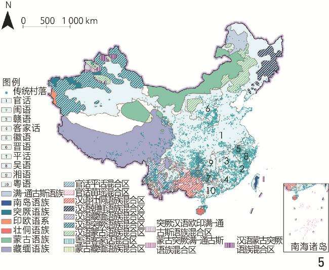
| 簇分区编号 | 地域范围 | 文化背景 | 语系 | 环境特点 | 特色传统民居 |
| 0 | 内蒙古阿拉善右旗、乌拉特后旗、临河区;甘肃;宁夏;青海东部局部片区 | 内蒙古文化、黄土高原文化、青藏高原游牧文化 | 官话、蒙古语族、藏缅语族、晋语 | 中海拔平原、中起伏中山 | 帐幕、毡房和蒙古包;庄窠式民居及羌式碉房;窑洞 |
| 1 | 安徽中部及南部地区;江苏南部地区;江西北部局部片区;湖北东部局部片区 | 淮河流域文化、荆湘文化、鄱阳文化、吴越文化 | 官话、客家话、徽语、赣语、吴语 | 小起伏低山、低海拔平原 | 皖南徽派民居;江南水乡民居;湘赣式民居 |
| 2 | 贵州中部及南部地区;广西北部局部片区 | 西南少数民族农业文化、巴蜀文化 | 官话、壮侗语族、苗瑶语族、客家话、湘语、藏缅语族 | 中起伏中山、小起伏低山、大起伏中山 | 干栏式木楼;湘赣式民居 |
| 3 | 山西中部及北部地区;河北西部地区;内蒙古中部地区;河南北部局部地区 | 内蒙古文化、黄土高原文化、燕赵文化、中原文化 | 晋语、官话、蒙古语族 | 中起伏中山、中海拔平原 | 窑洞;四合院;帐幕、毡房和蒙古包 |
| 4 | 云南西部地区;四川盐源县、米易县 | 西南少数民族农业文化、青藏高原游牧文化 | 官话、藏缅语族、壮侗语族、苗瑶语族 | 中起伏中山、小起伏中山 | 云南“一颗印”民居;彝族土掌房 |
| 5 | 福建中部及南部地区;江西中部及南部地区;广东东部局部片区 | 海峡西岸文化、鄱阳文化、岭南文化 | 客家话、闽语、赣语、苗瑶语族、官话 | 中起伏中山、小起伏低山、低海拔丘陵、低海拔台地、低海拔平原 | 闽南民居;客家围屋民居 |
| 6 | 新疆 | 北疆文化、南疆文化 | 官话、突厥语族、蒙古语族 | 低海拔平原、小起伏中山、中海拔平原、中起伏中山 | 阿以旺木构平顶建筑 |
| 7 | 陕西中部及东部地区;河南西部地区;山西南部局部片区;湖北北部局部片区; | 黄土高原文化、中原文化、荆湘文化 | 官话、晋语、蒙古语族 | 中海拔丘陵、中起伏中山、低海拔台地、小起伏低山 | 窑洞;狭长四合院;湘赣式民居 |
| 8 | 内蒙古东北部地区;黑龙江;吉林;辽宁东部地区 | 关东文化、内蒙古文化 | 官话、朝鲜语族、蒙古语族、满一通古斯语族 | 中海拔平原、低海拔丘陵、中起伏中山、小起伏低山 | 蒙古包、木刻楞;东北满、汉、朝鲜族民居 |
| 9 | 四川东部地区;陕西西部局部片区;甘肃南部局部片区;重庆西部局部片区;云南镇雄县、威信县 | 巴蜀文化、黄土高原文化 | 官话、苗瑶语族、藏缅语族 | 中海拔丘陵、低海拔台地、小起伏中山 | 干栏式木楼;窑洞;庄窠式民居及羌式碉房;干栏式木楼 |
| 10 | 重庆东部地区;湖南中部及北部地区;湖北西南部地区;贵州东北部局部片区 | 荆湘文化、巴蜀文化、西南少数民族农业文化 | 官话、湘语、苗瑶语族、赣语 | 小起伏低山、中起伏中山 | 干栏式木楼;湘赣式民居 |
| 11 | 西藏 | 青藏高原游牧文化 | 藏缅语族 | 中起伏高山、中起伏极高山 | 藏式碉房及其变体 |
| 12 | 浙江;上海;江苏南部局部片区;福建东北部局部片区 | 吴越文化、海峡西岸文化 | 吴语、闽语、官话 | 大起伏中山、低海拔平原、中起伏中山 | 江南水乡民居;廊屋式民居 |
| 13 | 海南;广西东南部地区;广东南部及东部局部片区 | 岭南文化、内蒙古文化、西南少数民族农业文化 | 壮侗语族、闽语、粤语 | 低海拔台地、小起伏低山、大起伏中山、低海拔平原 | 客家围屋民居 |
| 14 | 云南东部地区;贵州中部及南部地区;广西西北部地区 | 西南少数民族农业文化、巴蜀文化 | 藏缅语族、官话、壮侗语族、苗瑶语族 | 中起伏中山、小起伏中山、中起伏中山、小起伏低山、大起伏中山 | 土掌房;干栏式木楼 |
| 15 | 北京;河北东部及中部地区;内蒙古敖汉旗、松山区;山东 | 燕赵文化、齐鲁文化、关东文化、内蒙古文化 | 官话、蒙古语族 | 大起伏中山、中起伏中山、中海拔平原、小起伏低山、中起伏低山 | 平顶、囤顶等房屋构成的开阔四合院;土夯房 |
| 16 | 四川西部地区;云南西北部地区;西藏东部局部片区 | 青藏高原游牧文化、巴蜀文化、西南少数民族农业文化 | 藏缅语族、官话、苗瑶语族 | 中起伏中山、小起伏中山、中起伏高山、中起伏极高山 | 干栏式木楼;千脚落地房、木楞房;东坝民居 |
| 17 | 湖南南部地区;广东中部及西北部地区;广西东北部局部片区;江西西部局部地区 | 岭南文化、荆湘文化、鄱阳文化 | 湘语、粤语、客家话、苗瑶语族、赣语、官话 | 小起伏低山、低海拔平原、大起伏中山、低海拔丘陵、低海拔台地 | 湘赣式民居;客家围屋民居 |
| [1] |
许建和, 柳肃, 毛洲, 等. 中国传统村落的空间分布特征与保护系统方案[J]. 湖南大学学报(社会科学版), 2021, 35(2): 152-160.
XU J H, LIU S, MAO Z, et al. A Study on Spatial Distribution Characteristics and Protection System Scheme of Chinese Traditional Village[J]. Journal of Hunan University (Social Sciences), 2021, 35(2): 152-160.
|
| [2] |
周扬, 黄晗, 刘彦随. 中国村庄空间分布规律及其影响因素[J]. 地理学报, 2020, 75(10): 2206-2223.
ZHOU Y, HUANG H, LIU Y S. The Spatial Distribution Characteristics and Influencing Factors of Chinese Villages[J]. Acta Geographica Sinica, 2020, 75(10): 2206-2223.
|
| [3] |
李江苏, 王晓蕊, 李小建. 中国传统村落空间分布特征与影响因素分析[J]. 经济地理, 2020, 40(2): 143-153.
LI J S, WANG X R, LI X J. Spatial Distribution Characteristics and Influencing Factors of Chinese Traditional Villages[J]. Economic Geography, 2020, 40(2): 143-153.
|
| [4] |
李严, 姚旺, 张玉坤, 等. 中国传统村落空间分布特征[J]. 中国文化遗产, 2020, 4 51-59.
LI Y, YAO W, ZHANG Y K, et al. Spatial Distribution Characteristics of Traditional Villages in China[J]. China Cultural Heritage, 2020, 4 51-59.
|
| [5] |
周振鹤. 湖南历史文化地理研究 [M]. 上海: 复旦大学出版社, 1995.
ZHOU Z H. Preface to Historical and Cultural Geography of Hunan [M]. Shanghai: Fudan University Press, 1995.
|
| [6] |
张伟然.湖北历史文化地理研究[M].武汉: 湖北教育出版社, 2000.
ZHANG W R. Historical, Cultural and Geographical Studies in Hubei Province[M]. Wuhan: Hubei Education Press, 2000.
|
| [7] |
申秀英, 刘沛林, 邓运员, 等. 中国南方传统聚落景观区划及其利用价值[J]. 地理研究, 2006, 25(3): 485-494.
SHEN X Y, LIU P L, DENG Y Y, et al. Landscape Communities of Traditional Settlement in Southern China and Their Values of Conservation and Utilization[J]. Geographical Research, 2006, 25(3): 485-494.
|
| [8] |
胡最, 刘沛林, 邓运员, 等. 传统聚落景观基因的识别与提取方法研究[J]. 地理科学, 2015, 35(12): 1518-1524.
HU Z, LIU P L, DENG Y Y, et al. A Novel Method for Identifying and Separating Landscape Genes from Traditional Settlements[J]. Scientia Geographica Sinica, 2015, 35(12): 1518-1524.
|
| [9] |
胡最, 郑文武, 刘沛林, 等. 湖南省传统聚落景观基因组图谱的空间形态与结构特征[J]. 地理学报, 2018, 73(2): 317-332.
HU Z, ZHENG W W, LIU P L, et al. The Forms and Structures of Traditional Landscape Genome Maps: A Case Study of Hunan Province[J]. Acta Geographica Sinica, 2018, 73(2): 317-332.
|
| [10] |
胡最, 邓运员, 刘沛林, 等. 传统聚落文化景观基因的符号机制[J]. 地理学报, 2020, 75(4): 789-803.
HU Z, DENG Y Y, LIU P L, et al. The Semiotic Mechanism of Cultural Landscape Genes of Traditional Settlements[J]. Acta Geographica Sinica, 2020, 75(4): 789-803.
|
| [11] |
常青. 我国风土建筑的谱系构成及传承前景概观: 基于体系化的标本保存与整体再生目标[J]. 建筑学报, 2016, 10 1-9.
CHANG Q. Structure and Prospective of Chinese Vernacular Architectural Pedigrees an Objective Based on a Systematic Study of Sample Preservation and Holistic Regeneration[J]. Architectural Journal, 2016, 10 1-9.
|
| [12] |
刘大均, 胡静, 陈君子, 等. 中国传统村落的空间分布格局研究[J]. 中国人口·资源与环境, 2014, 24(4): 157-162.
LIU D J, HU J, CHEN J Z, et al. The Study of Spatial Distribution Pattern of Traditional Villages in China[J]. China Population, Resources and Environment, 2014, 24(4): 157-162.
|
| [13] |
卢松, 张小军, 张业臣. 徽州传统村落的时空分布及其影响因素[J]. 地理科学, 2018, 38(10): 1690-1698.
LU S, ZHANG X J, ZHANG Y C. Spatial-Temporal Distribution and Controlling Factors of Traditional Villages in Huizhou Region[J]. Scientia Geographica Sinica, 2018, 38(10): 1690-1698.
|
| [14] |
邹秋雨, 孙建伟, 杨丹丽, 等. 中国典型村落空间分布特征及影响因素: 基于4种村落的考察[J]. 地理科学, 2023, 43(4): 638-648.
ZOU Q Y, SUN J W, YANG D L, et al. Spatial Distribution Characteristics and Influencing Factors of Typical Chinese Villages: Based on the Investigation of Four Types Villages[J]. Scientia Geographica Sinica, 2023, 43(4): 638-648.
|
| [15] |
佟玉权. 基于GIS的中国传统村落空间分异研究[J]. 人文地理, 2014, 29(4): 44-51.
TONG Y Q. Research on the Spatial Differentiation of Chinese Traditional Village Based on Gis[J]. Human Geography, 2014, 29(4): 44-51.
|
| [16] |
方叶林, 陆海云, 黄震方, 等. 中国传统村落时空分布特征与影响因素[J]. 经济地理, 2023, 43(9): 187-196.
FANG Y L, LU H Y, HUANG Z F, et al. Spatiotemporal Distribution of Chinese Traditional Villages and Its Influencing Factors[J]. Economic Geography, 2023, 43(9): 187-196.
|
| [17] |
姜沛辰, 王柱. 基于MST聚类的区域传统村落分层协同网络构建探索: 以永州市传统村落集中连片保护利用为例[C]//中国城市规划学会城市规划新技术应用学术委员会, 广州市规划和自然资源自动化中心. 夯实数据底座·做强创新引擎·赋能多维场景: 2022年中国城市规划信息化年会论文集. 南宁: 广西科学技术出版社, 2022: 408-416.
JIANG P C, WANG Z. Hierarchical Collaborative Network Construction of Regional Traditional Villages Based on MST Clustering: A Case Study of the Concentrated Protection and Utilization of Traditional Villages in Yongzhou[C]//Urban Planning New Technology Application Academic Committee of Urban Planning Society of China, Guangzhou Planning and Natural Resources Automation Center. Strengthening Data Foundations, Boosting Innovation Engines, Empowering Multi-dimensional Scenarios: Proceedings of the 2022 China Urban Planning Informatization Annual Conference. Nanning: Guangxi Science and Technology Press, 2022: 408-416.
|
| [18] |
薛乾明, 黄跃昊. 传统村落集中连片保护利用格局构建方法: 以甘肃省两当县为例[J]. 规划师, 2024, 40(8): 66-74.
XUE Q M, HUANG Y H. Construction Method of the Concentrated Contiguous Protection and Utilization Pattern for Traditional Villages: An Empirical Study of Liangdang County, Gansu Province[J]. Planners, 2024, 40(8): 66-74.
|
| [19] |
蓝勇. 对中国历史文化地理研究的思考[J]. 学术研究, 2002, 1 87-90.
LAN Y. A Discussion on Chinese Historical Cultural Geography Study[J]. Academic Research, 2002, 1 87-90.
|
| [20] |
王淑佳, 孙九霞. 西南地区传统村落区域保护水平评价及影响因素[J]. 地理学报, 2022, 77(2): 474-491.
WANG S J, SUN J X. Evaluation and Influencing Factors of Regional Protection Level of Traditional Villages in Southwest China[J]. Acta Geographica Sinica, 2022, 77(2): 474-491.
|
| [21] |
周振鹤. 中国历史上自然区域、行政区划与文化区域相互关系管窥[J]. 历史地理, 2003, 1 1-9.
ZHOU Z H. An Outlook on the Relationship Among the Natural Area, Administrative Regionalization and Cultural Region in Chinese Historical Times[J]. Historical Geography, 2003, 1 1-9.
|
| [22] |
YANG J, HUANG X. The 30 m Annual Land Cover Dataset and Its Dynamics in China from 1990 to 2019[J]. Earth System Science Data, 2021, 13(8): 3907-3925.
|
| [23] |
宋正江, 赵耀, 龙彬. 传统村落文化景观区划定量方法及其应用研究: 以重庆为例[J]. 南方建筑, 2022, (2): 1-10.
SONG Z J, ZHAO Y, LONG B. A Quantitative Method for Cultural Landscape Zoning in Traditional Chinese Villages and Its Applications: A Case Study Based on Chongqing[J]. South Architecture, 2022, (2): 1-10.
|
| [24] |
孙林, 刘梦含, 徐久成. 基于优化初始聚类中心和轮廓系数的K-means聚类算法[J]. 模糊系统与数学, 2022, 36(1): 47-65.
SUN L, LIU M H, XU J C. K-Means Clustering Algorithm Using Optimal Initial Clustering Center and Contour Coefficient[J]. Fuzzy Systems and Mathematics, 2022, 36(1): 47-65.
|
| [25] |
凡来, 刘洋, 张大玉. 中国传统村落旅游发展空间格局及其影响因素[J]. 经济地理, 2023, 43(7): 203-214.
FAN L, LIU Y, ZHANG D Y. Spatial Pattern of Tourism Development of Chinese Traditional Villages and Its Influencing Factors[J]. Economic Geography, 2023, 43(7): 203-214.
|
| [26] |
康璟瑶, 章锦河, 胡欢, 等. 中国传统村落空间分布特征分析[J]. 地理科学进展, 2016, 35(7): 839-850.
KANG J Y, ZHANG J H, HU H, et al. Analysis on the Spatial Distribution Characteristics of Chinese Traditional Villages[J]. Progress in Geography, 2016, 35(7): 839-850.
|
| [27] |
徐柏翠, 潘竟虎. 中国国家级非物质文化遗产的空间分布特征及影响因素[J]. 经济地理, 2018, 38(5): 188-196.
XU B C, PAN J H. Spatial Distribution Characteristics of the Intangible Cultural Heritage in China[J]. Economic Geography, 2018, 38(5): 188-196.
|
| [28] |
罗德胤. 中国传统村落谱系建立刍议[J]. 世界建筑, 2014, 6 104-107,118.
LUO D Y. The Establishment of Chinese Traditional Villages[J]. World Architecture, 2014, 6 104-107,118.
|
| [29] |
李婧, 杨定海, 肖大威. 海南岛传统聚落及民居文化景观区划定量方法研究[J]. 小城镇建设, 2020, 38(5): 39-48.
LI J, YANG D H, XIAO D W. A Quantitative Study on the Cultural Landscape Division of the Traditional Settlements and Vernacular Dwellings in Hainan Island[J]. Development of Small Cities & Towns, 2020, 38(5): 39-48.
|
| [30] |
王文卿, 周立军. 中国传统民居构筑形态的自然区划[J]. 建筑学报, 1992, 4 12-16.
WANG W Q, ZHOU L J. Natural Division of Architectural Form of Traditional Houses in China[J]. Architectural Journal, 1992, 4 12-16.
|
| [31] |
王文卿, 陈烨. 中国传统民居的人文背景区划探讨[J]. 建筑学报, 1994, 7 42-47.
WANG W Q, CHEN Y. Discussion on Cultural Background Zoning of Traditional Dwellings in China[J]. Architectural Journal, 1994, 7 42-47.
|
| [32] |
汪德根, 吕庆月, 吴永发, 等. 中国传统民居建筑风貌地域分异特征与形成机理[J]. 自然资源学报, 2019, 34(9): 1864-1885.
WANG D G, LYU Q Y, WU Y F, et al. The Characteristic of Regional Differentiation and Impact Mechanism of Architecture Style of Traditional Residence[J]. Journal of Natural Resources, 2019, 34(9): 1864-1885.
|
| [33] |
韩聪.气候影响下的东北满族民居研究[D].哈尔滨: 哈尔滨工业大学, 2007.
HAN C. A Research on Climate Influence to Man Houses in Northeast of China[D]. Harbin: Harbin Institute of Technology, 2007.
|
| [34] |
王乐.东北地区朝鲜民族民居与家具特征的研究[D].哈尔滨: 东北林业大学, 2012.
WANG L. Research on Furniture Features of the Korean Minority in the Northeast Region[D]. Harbin: Northeast Forestry University, 2012.
|
| [35] |
韩小孩, 张耀辉, 孙福军, 等. 基于主成分分析的指标权重确定方法[J]. 四川兵工学报, 2012, 33(10): 124-126.
HAN X H, ZHANG Y H, SUN F J, et al. Determination Method of Index Weight Based on Principal Component Analysis[J]. Journal of Sichuan Ordnance, 2012, 33(10): 124-126.
|
| [36] |
侯文. 对应用主成分法进行综合评价的探讨[J]. 数理统计与管理, 2006, 25(2): 211-214.
HOU W. Discussing to Comprehensive Evaluation by Principal Component[J]. Application of Statistics and Management, 2006, 25(2): 211-214.
|
| [37] |
吴明隆.问卷统计分析实务SPSS操作与应用[M].重庆: 重庆大学出版社, 2010.
WU M L. Practice of Questionnaire Statistical Analysis[M]. Chongqing: Chongqing University Press, 2010.
|
/
| 〈 |
|
〉 |