
山水城市相地营城的数字化方法——以杭州钱塘江两岸地区为例
|
邵典/男/博士/东南大学建筑学院在站博士后、助理研究员/研究方向为数字化城市设计 |
|
杨俊宴/男/博士/东南大学建筑学院教授/本刊编委/研究方向为智能城市设计 |
收稿日期: 2024-12-17
修回日期: 2025-06-24
网络出版日期: 2025-12-09
基金资助
国家自然科学基金青年科学基金项目“基于‘数-形’双通量图谱的高密度街区形态测度模型与交互转译方法研究”(52308051)
版权
Digital Methods for Construction of Shan-Shui City in Combination with Local Geographical Conditions: A Case Study of the Areas along Both Banks of the Qiantang River in Hangzhou
|
SHAO Dian, Ph.D., is a postdoctoral researcher and assistant research fellow in the School of Architecture, Southeast University. His research focuses on digital urban design |
|
YANG Junyan, Ph.D., is a professor in the School of Architecture, Southeast University, and an editorial board member of this journal. His research focuses on intelligent urban design |
Received date: 2024-12-17
Revised date: 2025-06-24
Online published: 2025-12-09
Copyright
相地营城是中国自古以来在城市建设实践过程中形成的独特营建智慧。大数据背景下,如何借助数字化技术将传统的相地营城智慧在现代城市建设中予以继承与发扬,仍值得进一步探索。
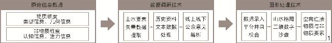
基于多源大数据与数字模型,针对生境网络、景观环境等山水城市核心要素,提出山水格局数字化梳理(理脉)、生境网络数字化解析(通廊)、三维形态数字化营建(塑形)的方法体系。
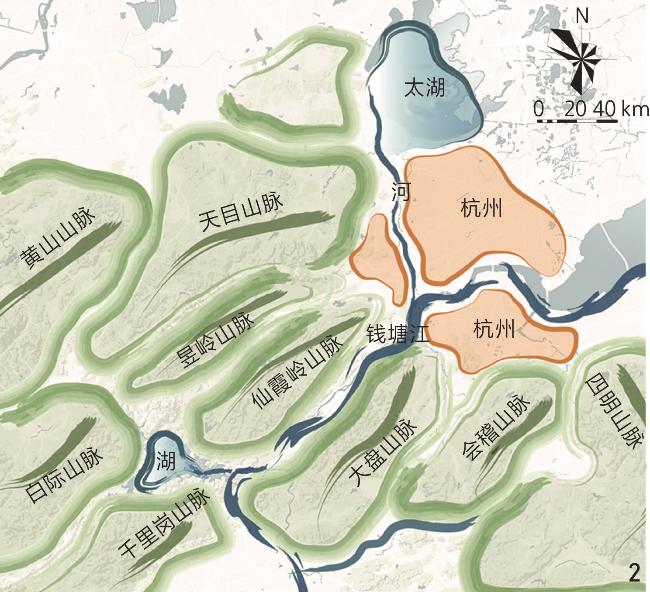
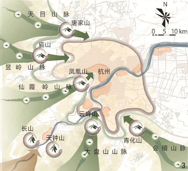
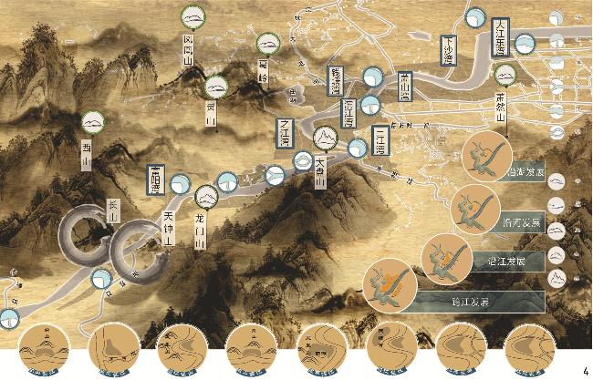
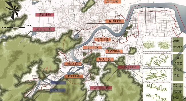
进而以杭州钱塘江两岸地区为例,对山簇、水系、景观等山水格局进行控制,优化了核、斑、廊、岛的生境网络体系,并对城市形态做出修正。
以科学量化的方式识别山水城市的空间基因,可为当代山水城市营建提供基于传统相地营城智慧的数字化方法。
邵典 , 杨俊宴 . 山水城市相地营城的数字化方法——以杭州钱塘江两岸地区为例[J]. 风景园林, 2025 , 32(8) : 111 -118 . DOI: 10.3724/j.fjyl.LA20240126
“Urban construction in combination with local geographical conditions” is a unique construction wisdom formed in the practice of urban construction in China since ancient times, which means selecting urban construction forms that are compatible with natural elements such as mountain topography and water patterns, ecological green corridors, and climatic conditions, based on a thorough investigation of such elements, with a focus on the harmonious relationship between man and land, and man and nature. As for how to inherit and carry forward the traditional practical wisdom of urban construction in combination with local geographical conditions in the modern city construction, the current academic research can be divided into three aspects: Shan-Shui city construction focusing on the relationship between city and nature, man-land relationship coordination focusing on the relationship between man and nature, and spatial gene recognition based on the interpretation of city history. However, such research primarily identifies spatial genes from the perspective of history, landscape space, etc., which is ultimately a kind of qualitative summary of experience and model generalization. How to accurately identify the genes of a city from its complex morphological patterns and embed them in the process of urban construction in combination with local geographical conditions needs more detailed and scientific quantitative means to achieve.
In the context of the era of big data, while studying and interpreting the wisdom of the traditional urban construction in combination with local geographical conditions, it is also necessary to explore how to use digital technology to inherit and innovate the traditional method. This research explores the digital method for construction of Shan-Shui cities in combination with local geographical conditions, which involves the three steps of “contextual analysis”, “corridor connection” and “shaping”. Specifically, “contextual analysis” refers to the digital sorting of landscape patterns formed by mountains and waterways, involving dividing landscape elements into different levels, identifying landscape pattern information through digital methods such as natural language processing and GIS, establishing a database, and constructing an index system including proximity index and topological connectivity for analysis; “corridor connection” refers to the digital identification and connection optimization of four types of ecological network elements, namely core protected areas, habitat patches, corridor structures, and stepping stone structures, to build a multi-level urban ecological pattern from a digital perspective; “shaping” refers to the shaping of a three-dimensional urban spatial form that connects the spatial elements of landscape pattern through digital analysis methods such as landscape viewing systems and physical environment simulation, so that the spatial elements of landscape pattern can serve urban residents as much as possible. Then the landscape pattern, habitat network and urban form of the target city are comprehensively analyzed and improved.
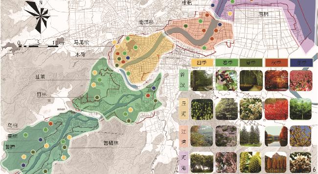
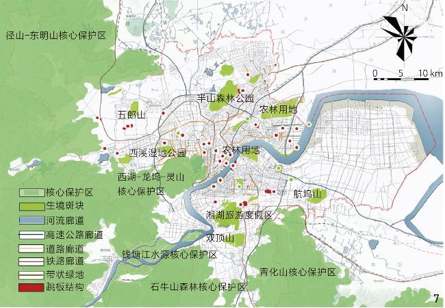
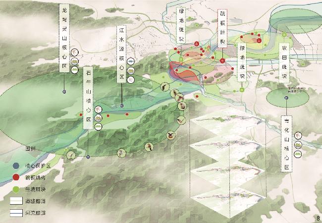
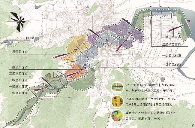
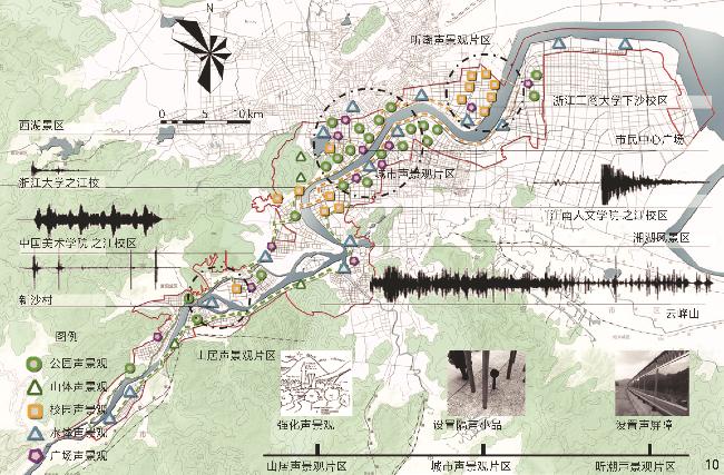
This research selects the area along both banks of the Qiantang River in Hangzhou as the research area, analyzes and assesses its landscape pattern, ecological security, and urban morphology, and proposes corresponding optimization strategies. The research finds that in terms of landscape pattern, the multi-scale landscape pattern of “region – city – block” of the Qiantang River is digitally sorted out, and corresponding optimization and control strategies are proposed for the landscape pattern on both banks of the Qiantang River, involving the three aspects of mountain cluster control, water system control and landscape control. In terms of habitat network, MSPA method and GIS minimum path cost method are used to identify and extract the four kinds of natural elements of “core area, ecological batch, corridor, and island”, with a total of 5 core protected areas, 19 habitat patches, 53 ecological corridors and 42 springboard structures extracted, and plant layout, washing distribution and greening layout are optimized and adjusted. In terms of three-dimensional form, the city’s mountains and high-rise buildings are optimized through the overlooking gallery and urban skyline to highlight local characteristics. At the same time, the simulation results of wind environment, acoustic environment and thermal environment are combined to create ventilation corridors to reduce noise pollution and heat island effect.
The digital approach proposed in this research is based on the inherent characteristics of the elements of Shan-Shui cities such as mountains, waters, habitats and landscapes. It applies big data and digital technologies to the entire process of site analysis and urban planning gradually in a scientific and quantitative way, identifying the intrinsic spatial genes one by one accompanied by necessary problem analysis and optimization design, and further improving the methodological system of site analysis and urban planning. This research aims to identify the spatial genes of Shan-Shui cities in a scientific and quantifiable way, so as to provide a digital method based on traditional wisdom of site selection and city construction for contemporary urban construction, and endow the traditional city-building model with new vitality through the application of digital technology.
文中图表均由作者绘制。
| [1] |
王建国, 吴晨, 杨俊宴, 等. 中华古都营城智慧的创新探索: 北京老城总体城市设计的实践与思考[J]. 城市规划, 2024, 48(8): 4-15.
WANG J G, WU C, YANG J Y, et al. Innovative Exploration of Wisdom in Constructing Ancient Chinese Capitals: Practices and Reflections on the Integrated Urban Design of Beijing’s Old City[J]. City Planning Review, 2024, 48(8): 4-15.
|
| [2] |
王树声, 赵子良, 李小龙, 等. 以文相地: 一种人文视角考量城市建设用地的规划理念[J]. 城市规划, 2019, 43(5): 87-88.
WANG S S, ZHAO Z L, LI X L, et al. Viewing the Land with Culture: A Humanistic Perspective to Consider the Planning Concept of Urban Construction Land[J]. City Planning Review, 2019, 43(5): 87-88.
|
| [3] |
郑浩, 王丰, 宣甲, 等. 山水城市总体城市设计的探索: 以台州市中心城区为例[J]. 城市规划, 2020, 44(S1): 106-119.
ZHENG H, WANG F, XUAN J, et al. Integrated Urban Design of Shan-Shui City: A Case Study of Taizhou Central City[J]. City Planning Review, 2020, 44(S1): 106-119.
|
| [4] |
ROGGEMA R, RUBIO CISNEROS I I, JUNCO LÓPEZ R, et al. Loving and Healing a Hurt City: Planning a Green Monterrey Metropolitan Area[J]. Land, 2025, 14(1): 164.
|
| [5] |
黄道远, 徐有钢, 王佳文. 基于山水营城理念的福州总体城市设计策略[J]. 规划师, 2024, 40(S2): 15-23.
HUANG D Y, XU Y G, WANG J W. Overall Urban Design Strategy for Fuzhou Based on the Concept of Shan-Shui City Planning[J]. Planners, 2024, 40(S2): 15-23.
|
| [6] |
陶涛, 刘泉. 为何西方城市设计无法完整展示中国城市美学: 山水诗画视角下的三个问题分析[J]. 城市规划, 2023, 47(4): 79-85.
TAO T, LIU Q. Why Can’t Western Urban Design Fully Display Chinese Urban Aesthetics: Analysis of Three Problems from the Chinese Shanshui Poetry and Painting Perspective[J]. City Planning Review, 2023, 47(4): 79-85.
|
| [7] |
石谦飞, 李昉芳, 景一帆, 等. 晋东南传统聚落水环境适应性营造智慧: 以晋城市泽州县南峪村为例[J]. 西部人居环境学刊, 2021, 36(6): 134-140.
SHI Q F, LI F F, JING Y F, et al. Water Environment Adapted Building Wisdom of the Traditional Villages in the Southeast of Shanxi Province: Take Nanyu Village in Zezhou County as an Example[J]. Journal of Human Settlements in West China, 2021, 36(6): 134-140.
|
| [8] |
NAWAR A H, SAEED A A. Sustainable Development for Urban Prosperity in Harmony Between Nature and Architecture[J]. Asian Journal of Water, Environment and Pollution, 2023, 20(1): 105-113.
|
| [9] |
段进, 姜莹, 李伊格, 等. 空间基因的内涵与作用机制[J]. 城市规划, 2022, 46(3): 7-14.
DUAN J, JIANG Y, LI Y G, et al. Space Gene: Connotation and Functional Mechanism[J]. City Planning Review, 2022, 46(3): 7-14.
|
| [10] |
肖竞, 张晴晴, 杨亚林, 等. 山地历史城镇景观基因“双系统”解译及其特征保护与气韵传承[J]. 中国园林, 2021, 37(6): 43-48.
XIAO J, ZHANG Q Q, YANG Y L, et al. “Dual System” Landscape Genes Interpretation, Feature Preser Vation and Charm Inheritance of Mountainous Historical Towns[J]. Chinese Landscape Architecture, 2021, 37(6): 43-48.
|
| [11] |
赵万民, 廖心治, 王华. 山地形态基因解析: 历史城镇保护的空间图谱方法认知与实践[J]. 规划师, 2021, 37(1): 50-57.
ZHAO W M, LIAO X Z, WANG H. Analysis of Mountain Morphological Genes: Cognition and Practice of Spatial Map Method of Historical Town Protection[J]. Planners, 2021, 37(1): 50-57.
|
| [12] |
吴朋睿, 尹竣丰, 张戬, 等. “山水营城”视角下桂林历史城区演变探究[C]. 中国城市规划学会.人民城市, 规划赋能: 2023中国城市规划年会论文集(09城市文化遗产保护).武汉: 中国城市规划学会, 2023: 46-55.
WU P R, YIN J F, ZHANG J, et al. Research on the Evolution of Guilin’s Historical Urban Area from the Perspective of “Mountain and Water Urban Planning”[C]. Chinese Society of City Planning. People’s City, Planning Empowerment: Proceedings of the 2023 China Urban Planning Conference (09 Urban Cultural Heritage Protection). Wuhan: Chinese Society of City Planning, 2023: 46-55.
|
| [13] |
DAVISON M C. Sculpting Nature, Making Place: The Aesthetics and Ethics of Land-Shaping in Seattle[D]. Irvine: University of California, 2023.
|
| [14] |
李旭, 陈代俊, 罗丹. 城市形态基因的生成机理与传承途径研究: 以成都为例[J]. 城市规划, 2022, 46(4): 44-53.
LI X, CHEN D J, LUO D. Morphogenesis and Inheritance of Urban Morphological Gene: A Case Study of Chengdu[J]. City Planning Review, 2022, 46(4): 44-53.
|
| [15] |
王建国. 从理性规划的视角看城市设计发展的四代范型[J]. 城市规划, 2018, 42(1): 9-19.
WANG J G. Four Generations of Urban Design Paradigm from a Rational Planning Perspective[J]. City Planning Review, 2018, 42(1): 9-19.
|
| [16] |
吴丽琴. 国土空间背景下总体城市设计融入生态导向策略研究[J]. 住宅与房地产, 2024(33): 68-70.
WU L Q. Research on the Integration of Ecological-Oriented Strategies into Overall Urban Design under the Background of National Spatial Planning[J]. Housing and Real Estate, 2024(33): 68-70.
|
| [17] |
齐羚. 术艺结合 以形媚道: 圆明园土山理法与中国传统园林的生态智慧[J]. 中国园林, 2015, 31(2): 110-114.
QI L. Combination of Technology and Art, and Explaining the Taosim with Shape: The Eco-Wisdom in the Landscape Artificial Mound Design Methods of Yuanmingyuan and Chinese Traditional Garden[J]. Chinese Landscape Architecture, 2015, 31(2): 110-114.
|
| [18] |
孟兆祯. 园衍[M]. 北京: 中国建筑工业出版社, 2012.
MENG Z Z. Yuanyan[M]. Beijing: China Architecture & Building Press, 2012.
|
| [19] |
谭瑛, 陈潘婉洁. 数·形·理: 城市山水脉络信息图谱的建构三法[J]. 中国园林, 2018, 34(10): 88-92.
TAN Y, CHEN P W J. Data, Graphics, and Analysis: Three Methods of Construction of Urban Landscape Network Information Map[J]. Chinese Landscape Architecture, 2018, 34(10): 88-92.
|
| [20] |
谭瑛, 姚青杉. 基于生境网络的山水城市生态格局模式研究[J]. 中国园林, 2015, 31(5): 92-96.
TAN Y, YAO Q S. Research on the Ecological Pattern of Shan-Shui Cities Based on Habitat Network[J]. Chinese Landscape Architecture, 2015, 31(5): 92-96.
|
| [21] |
肖华斌, 张慧莹, 刘莹, 等. 自然资源整合视角下泰山区域生态网络构建研究[J]. 上海城市规划, 2020(1): 42-47.
XIAO H B, ZHANG H Y, LIU Y, et al. Study on the Construction of Ecological Network of the Taishan Area Based on Natural Resources Integration[J]. Shanghai Urban Planning Review, 2020(1): 42-47.
|
| [22] |
李佳杰, 邢忠, 李旭. 基于电路理论的城市高温控制优先区域识别: 以重庆市中心城区为例[J]. 中国园林, 2024, 40(11): 97-103.
LI J J, XING Z, LI X. Identification of Priority Areas for Urban Heat Mitigation Based on Circuit Theory: A Case Study of Chongqing’s Central City[J]. Chinese Landscape Architecture, 2024, 40(11): 97-103.
|
| [23] |
杨俊宴, 孙欣, 潘奕巍, 等. 景与观: 城市眺望体系的空间解析与建构途径[J]. 城市规划, 2020, 44(12): 103-112.
YANG J Y, SUN X, PAN Y W, et al. Landscape and View: Spatial Analysis and Construction Ways of View System in City[J]. City Planning Review, 2020, 44(12): 103-112.
|
| [24] |
齐羚, 马梓烜, 郭雨萌, 等. 基于微气候适应性设计的天津市蓟州区西井峪村山水格局分析[J]. 中国园林, 2018, 34(2): 34-41.
QI L, MA Z X, GUO Y M, et al. Study on the Mountain-Water Patterns of Xijingyu Village in Jizhou District, Tianjin Based on the Comprehensive Analysis of Micro-Climate Adaptability and Design Mechanism[J]. Chinese Landscape Architecture, 2018, 34(2): 34-41.
|
| [25] |
SU W X, ZHANG L K, CHANG Q. Nature-Based Solutions for Urban Heat Mitigation in Historical and Cultural Block: The Case of Beijing Old City[J]. Building and Environment, 2022, 225: 109600.
|
/
| 〈 |
|
〉 |