
上海市城乡林水复合生态系统类型识别与修复潜力
|
孙道千/男/硕士/国家林业和草原局产业发展规划院工程师/研究方向为风景园林规划与设计 |
|
孙维然/女/硕士/国家林业和草原局产业发展规划院工程师/研究方向为风景园林规划与设计 |
|
刘世梁/男/博士/北京师范大学环境学院教授/研究方向为景观生态学 |
|
王洁/女/硕士/上海园林绿化建设有限公司高级工程师/研究方向为风景园林规划与设计 |
收稿日期: 2024-11-08
修回日期: 2025-07-05
网络出版日期: 2025-12-09
基金资助
国家重点研发计划“长江流域重点生态区山水林田湖草沙耦合机制与系统修复模式”(2022YFF1303204)
国家自然科学基金面上项目“耦合生态足迹核算的区域人类活动对生态系统服务流的影响机理”(42271097)
上海建工集团重点科研项目“上海城市公园林水复合片区碳汇监测核算及提升技术研究与示范”(24JCSF-24)
上海市2022年度“科技创新行动计划”科技支撑碳达峰碳中和专项项目“碳足迹分析与固碳潜势定量模型”(22dz1209403)
版权
Identification and Restoration Potential of Urban-Rural Forest-Water Composite Ecosystems
|
SUN Daoqian, Master, is an engineer in the Industry Development and Planning Institute, National Forestry and Grassland Administration. His research focuses on landscape planning and design |
|
SUN Weiran, Master, is an engineer in the Industry Development and Planning Institute, National Forestry and Grassland Administration. Her research focuses on landscape planning and design |
|
LIU Shiliang, Ph.D., is a professor in the School of Environment, Beijing Normal University. His research focuses on landscape ecology |
|
WANG Jie, Master, is a senior engineer in Shanghai Gardening-Landscaping Construction Co., Ltd. Her research focuses on landscape planning and design |
Received date: 2024-11-08
Revised date: 2025-07-05
Online published: 2025-12-09
Copyright
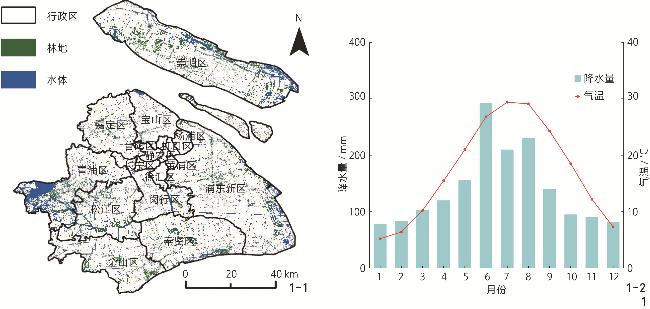
上海作为水网密集型城市,长期面临林水空间利用矛盾突出、生态系统功能协同不足、缺乏水绿一体化建设评估标准等问题,制约了生态系统服务能力的提升与蓝绿空间一体化建设的推进。为回应当前“林水复合·水绿融合”建设的迫切需求,须构建面向城乡生态修复的林水复合区域系统识别思路,以支撑不同类型区域的生态修复潜力评估。
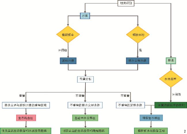
利用上海市2021—2023年的高时空分辨率影像数据,提出并应用一套林水复合区域分类与识别方法,划分生态融合区、基础林水交界区和待恢复水林区3种类型,结合季节和月度动态指标评估地表植被覆盖及淹水状况,开发针对性评估林水复合生态系统修复潜力的标准化方法。
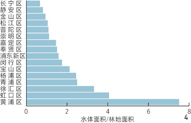
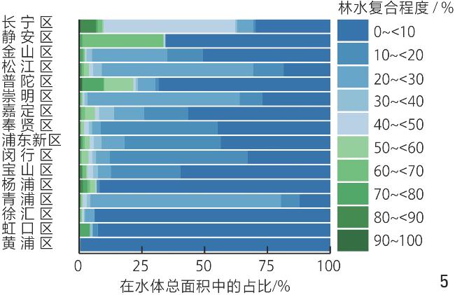
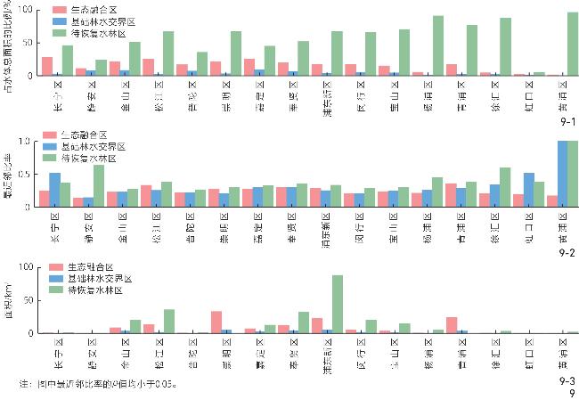
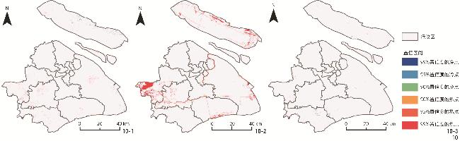
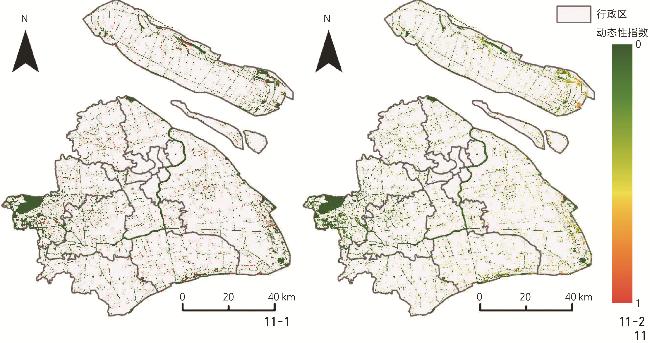
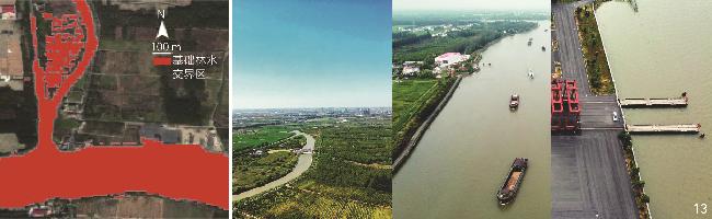
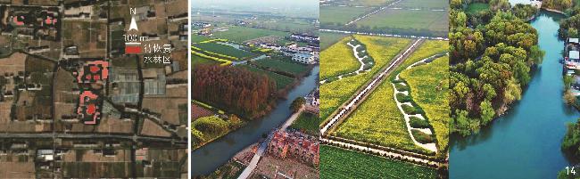
1)3类林水复合区域在空间分布上呈现显著差异,生态融合区、基础林水交界区和待恢复水林区的总面积分别为128.90、447.54和25.56 km2,占上海市水体总面积的19%、66%和4%。2)不同林水复合类型区域表现出差异化的动态特征,待恢复水林区表现出最高的动态性,生态融合区次之,基础林水交界区保持相对稳定。3)空间分布上,3类林水复合区域呈现显著的城乡异质性,远郊地区保有更多适宜营建和修复的土地资源,而中心城区虽紧邻主干河流,但因硬质驳岸等原因,林水复合程度明显较低。
构建的面向城市生态修复的林水复合区域分类与识别体系,揭示了上海市不同区域的生态格局特征和演变机制,为精准施策提供了依据。该研究方法具有良好的通用性,可为其他水网密集型城市的生态空间规划与林水系统优化提供借鉴路径。
孙道千 , 孙维然 , 刘世梁 , 王洁 . 上海市城乡林水复合生态系统类型识别与修复潜力[J]. 风景园林, 2025 , 32(8) : 30 -39 . DOI: 10.3724/j.fjyl.LA20240024
Shanghai, a densely populated megacity with a dense water network, faces challenges such as fragmented forest – water configurations, weak coordination among ecosystem functions, and the lack of standardized frameworks for integrated blue – green spatial planning. These issues constrain ecological capacity and urban planning effectiveness. In response to the urgent need for promoting “forest – water composition” and “water – green integration” as key directions in ecological spatial governance, this study proposes a technical framework for identifying forest – water composite zones and evaluating their restoration potential, aiming to provide spatially explicit ecological management and restoration strategies.
Taking Shanghai as a case study with its complex hydrological background and dynamic land use, this study uses high resolution satellite images from 2021 to 2023 were processed on the Google Earth Engine platform. Forests and water bodies were extracted using Sentinel-derived Dynamic World land cover products and spectral indices (EVI, NDVI, MNDWI, and LSWI). Seasonal water extent was delineated from maximum water distribution between April and September (2021−2023) to capture hydrological dynamics. A multi-step classification and evaluation system was constructed. Water – forest adjacency was quantified using a spatial adjacency index (shared perimeter over total water perimeter), and water body complexity was measured through the perimeter – area ratio. Dynamic characteristics of vegetation and water cover were calculated at monthly and seasonal scales to establish the seasonal (Is) and monthly (Im) dynamic indices. Based on spatial proximity and temporal variability, forest – water composite zones were classified into three categories: 1) Ecological integration zones (adjacent with sedimentation); 2) basic forest – water interface zone (adjacent but weak dynamics); 3) water – forest zones to be restored (sedimentation but lacking forested edges). Spatial patterns are analyzed using Getis-Ord Gi* statistics and nearest neighbor analysis. Restoration potential is assessed through dynamic indicators, spatial adjacency, and available surrounding land.
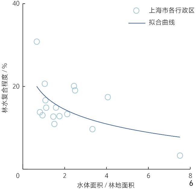
The results reveal distinct spatial differentiation. The ecological integration zones, basic forest – water interface zones, and water – forest zones to be restored respectively occupy an area of 128.90 km2, 447.54 km2, and 25.56 km2, representing 19%, 66% and 4% of Shanghai's total water area. Ecological integration zones are primarily distributed in outer districts such as Qingpu and Chongming, corresponding to sediment-rich lakes and wide rivers with forest margins. Basic forest – water interface zones are more evenly spread but concentrated in central districts (e.g., Huangpu, Yangpu, Xuhui), where adjacency exists but dynamic transformation is minimal due to shoreline hardening. Water – forest zones to be restored are typically located at the margins of open water and disturbed lands, including abandoned ponds and silted tributaries. Dynamic analysis shows the highest ecological fluctuation in zones to be restored (Is = 0.41; Im = 0.26), suggesting strong seasonal responsiveness and vulnerability; ecological integration zones exhibit moderate variability (Is = 0.30; Im = 0.15), indicating stable connectivity with restoration potential; basic forest – water interface zone remain largely static (Is = 0.04; Im = 0.01), often due to artificial modification. Urban – rural gradient analysis reveals significant heterogeneity. Suburban districts such as Songjiang and Jiading host larger composite patches, with significant clustering (p < 0.01), implying high restoration opportunities. In contrast, central areas show fragmented, random distributied patches. Statistical tests confirm no significant relationship between forest – water composite level and water area or shape complexity (p > 0.05), indicating that composite potential is primarily driven by anthropogenic regulation and policy interventions rather than natural morphology.
This research establishes a standardized, scalable classification and evaluation framework for forest – water composite ecosystems, applicable to complex urban landscapes. Through spatial disaggregation and dynamic assessment, the research uncovers the multi-scalar heterogeneity and ecological transformation patterns of Shanghai’s forest – water systems, enabling precise zoning, targeted restoration, and evidence-based planning. The research further proposes a governance model based on “core – corridor – reserve” spatial logic: Preserving ecological integration zones as biodiversity-rich ecological cores, enhancing basic forest – water interface zones as green – blue corridors, and prioritizing water – forest zones to be restored through adaptive restoration tailored to hydrological and vegetative feedbacks. In central urban areas, vertical ecological integration technologies (e.g., sponge structures, terrace planting) are recommended to overcome spatial constraints, whereas in suburban districts, horizontal corridor expansion is prioritized. The proposed methodological system responds to the urgent need for spatially explicit, process-informed planning tools in water-rich, development-intensive cities. By integrating structural and dynamic metrics, this framework advances understanding of composite ecosystem resilience and provides a practical toolset for restoration prioritization under future climate and land use scenarios. The findings have broader implications for ecological governance in deltaic and river-network cities, offering a transferrable reference for implementing synergistic blue – green infrastructure strategies.
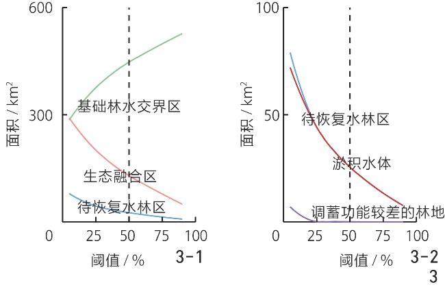
图6 水林面积比与林水复合程度的关系Fig. 6 Relationship between the water - forest area ratio and the degree of forest – water integration |
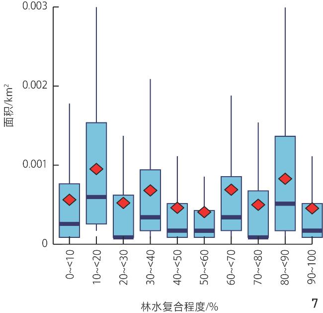
图7 不同林水复合程度水体的面积分布Fig. 7 Distribution of water body areas across different forest – water composite levels |
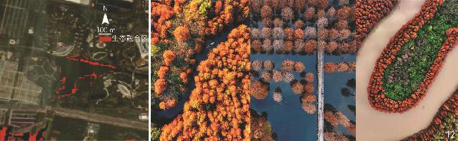
文中图表均由作者绘制,其中
| [1] |
蔡益杭, 张明如, 张建国. 浙江青山湖绿道小气候要素与游人游憩行为的关系探析[J]. 生态科学, 2023, 42(4): 154-162.
CAI Y H, ZHANG M R, ZHANG J G. Experimental Research on Correlation Between Microclimate Factors and Visitors’ Recreational Behavior in Zhejiang Qingshan Lake Greenway[J]. Ecological Science, 2023, 42(4): 154-162.
|
| [2] |
饶显龙, 黄若之, 史琰, 等. 凝练地域特色, 营造水上森林: 宁波植物园湿生木本植物专类园规划设计及营建解析[J]. 中国园林, 2020, 36(5): 116-121.
RAO X L, HUANG R Z, SHI Y, et al. Condense Regional Characteristics and Construct the Forest on Water: Analysis of the Planning and Design and Construction of Wet Woody Plants Specialized Garden in Ningbo Botanical Garden[J]. Chinese Landscape Architecture, 2020, 36(5): 116-121.
|
| [3] |
CASTELLANO M J, ARCHONTOULIS S V, HELMERS M J, et al. Sustainable Intensification of Agricultural Drainage[J]. Nature Sustainability, 2019, 2(10): 914-921.
|
| [4] |
CHENG F Y, VAN METER K J, BYRNES D K, et al. Maximizing US Nitrate Removal Through Wetland Protection and Restoration[J]. Nature, 2020, 588(7839): 625-630.
|
| [5] |
STERLING S M, DUCHARNE A, POLCHER J. The Impact of Global Land-Cover Change on the Terrestrial Water Cycle[J]. Nature Climate Change, 2013, 3(4): 385-390.
|
| [6] |
诸逸凡, 刘志强, 余慧, 等. 兼顾空间公平和效率的苏州市中心城区社区公园布局测度研究[J]. 风景园林, 2024, 31(8): 122-129.
ZHU Y F, LIU Z Q, YU H, et al. Research on Measurement of the Layout of Community Parks in the Central Urban Area of Suzhou that Takes into Account Both Spatial Equity and Efficiency[J]. Landscape Architecture, 2024, 31(8): 122-129.
|
| [7] |
上海市水务局办公室. 在本市河湖治理中推进林水复合建设试点的指导意见: 沪水务〔2023〕430号[EB/OL].(2023-06-30)[2024-11-07]. https://swj.sh.gov.cn/zcwj/20230712/016ee7b5f46446b29cd37d29511046f1.html.
General Office of Shanghai Water Authority. Guidance on Promoting Forest-Water Composite Construction Pilot Projects in Shanghai’s River and Lake Management: Shanghai Water Document 〔2023〕 No. 430[EB/OL]. (2023-06-30)[2024-11-07]. https://swj.sh.gov.cn/zcwj/20230712/016ee7b5f46446b29cd37d29511046f1.html.
|
| [8] |
上海市水务局办公室. 关于本市推进林水复合建设试点工作的通知: 沪水务〔2023〕627号[EB/OL].(2023-08-23)[2024-11-07]. https://www.shanghai.gov.cn/gwk/search/content/f74ac7edd9a24eb2a5a146de7b1541fa.
General Office of Shanghai Water Authority. Notice on Promoting Forest-Water Composite Construction Pilot Work in Shanghai: Shanghai Water Document 〔2023〕 No. 627[EB/OL]. (2023-08-23)[2024-11-07]. https://www.shanghai.gov.cn/gwk/search/content/f74ac7edd9a24eb2a5a146de7b1541fa.
|
| [9] |
GODFROY J, LEJOT J, DEMARCHI L, et al. Combining Hyperspectral, LiDAR, and Forestry Data to Characterize Riparian Forests Along Age and Hydrological Gradients[J]. Remote Sensing, 2023, 15(1): 17.
|
| [10] |
RAULINGS E J, MORRIS K, ROACHE M C, et al. The Importance of Water Regimes Operating at Small Spatial Scales for the Diversity and Structure of Wetland Vegetation[J]. Freshwater Biology, 2010, 55(3): 701-715.
|
| [11] |
RESCHKE J, HÜTTICH C. Continuous Field Mapping of Mediterranean Wetlands Using Sub-Pixel Spectral Signatures and Multi-temporal Landsat Data[J]. International Journal of Applied Earth Observation and Geoinformation, 2014, 28: 220-229.
|
| [12] |
姚鑫, 杨桂山, 万荣荣, 等. 水位变化对河流、湖泊湿地植被的影响[J]. 湖泊科学, 2014, 26(6): 813-821.
YAO X, YANG G S, WAN R R, et al. Impact of Water Level Change on Wetland Vegetation of Rivers and Lakes[J]. Journal of Lake Sciences, 2014, 26(6): 813-821.
|
| [13] |
BHATNAGAR S, GILL L, REGAN S, et al. A Nested Drone-Satellite Approach to Monitoring the Ecological Conditions of Wetlands[J]. ISPRS Journal of Photogrammetry and Remote Sensing, 2021, 174: 151-165.
|
| [14] |
PAROLIN P. Submerged in Darkness: Adaptations to Prolonged Submergence by Woody Species of the Amazonian Floodplains[J]. Annals of Botany, 2009, 103(2): 359-376.
|
| [15] |
KUDOYAROVA G R, DODD I C, VESELOV D S, et al. Common and Specific Responses to Availability of Mineral Nutrients and Water[J]. Journal of Experimental Botany, 2015, 66(8): 2133-2144.
|
| [16] |
TAN X F, XU H, KHAN S, et al. Plant Water Transport and Aquaporins in Oxygen-Deprived Environments[J]. Journal of Plant Physiology, 2018, 227: 20-30.
|
| [17] |
TRIFILÒ P, ABATE E, PETRUZZELLIS F, et al. Critical Water Contents at Leaf, Stem and Root Level Leading to Irreversible Drought-Induced Damage in Two Woody and One Herbaceous Species[J]. Plant, Cell & Environment, 2023, 46(1): 119-132.
|
| [18] |
OW L F, GHOSH S. Urban Tree Growth and Their Dependency on Infiltration Rates in Structural Soil and Structural Cells[J]. Urban Forestry & Urban Greening, 2017, 26: 41-47.
|
| [19] |
MA X Y, CHEN H S, NIE Y P. Common Species Maintain a Large Root Radial Extent and a Stable Resource Use Status in Soil-Limited Environments: A Case Study in Subtropical China[J]. Frontiers in Plant Science, 2020, 11: 1260.
|
| [20] |
ROWAN G S L, KALACSKA M. A Review of Remote Sensing of Submerged Aquatic Vegetation for Non-specialists[J]. Remote Sensing, 2021, 13(4): 623.
|
| [21] |
JIA M M, WANG Z M, WANG C, et al. A New Vegetation Index to Detect Periodically Submerged Mangrove Forest Using Single-Tide Sentinel-2 Imagery[J]. Remote Sensing, 2019, 11(17): 2043.
|
| [22] |
KHAN R M, SALEHI B, MAHDIANPARI M, et al. A Meta-analysis on Harmful Algal Bloom (HAB) Detection and Monitoring: A Remote Sensing Perspective[J]. Remote Sensing, 2021, 13(21): 4347.
|
| [23] |
THOMAS R F, KINGSFORD R T, LU Y, et al. Mapping Inundation in the Heterogeneous Floodplain Wetlands of the Macquarie Marshes, Using Landsat Thematic Mapper[J]. Journal of Hydrology, 2015, 524: 194-213.
|
| [24] |
陆小波, 杨俊宴. 中型平原水网城市空间形态特征研究[J]. 城市规划, 2018, 42(12): 109-115.
LU X B, YANG J Y. A Study on Spatial Form and Characteristics of the Medium-Sized River Plain Cities[J]. City Planning Review, 2018, 42(12): 109-115.
|
| [25] |
WANG X X, XIAO X M, ZOU Z H, et al. Tracking Annual Changes of Coastal Tidal Flats in China During 1986−2016 Through Analyses of Landsat Images with Google Earth Engine[J]. Remote Sensing of Environment, 2020, 238: 110987.
|
| [26] |
HELZER C J, JELINSKI D E. The Relative Importance of Patch Area and Perimeter-Area Ratio to Grassland Breeding Birds[J]. Ecological Applications, 1999, 9(4): 1448-1458.
|
| [27] |
VIDAL RUIZ E. An Algorithm for Finding Nearest Neighbours in (Approximately) Constant Average Time[J]. Pattern Recognition Letters, 1986, 4(3): 145-157.
|
| [28] |
TURNER M G, GARDNER R H, O’NEILL R V. Landscape Ecology in Theory and Practice: Pattern and Process[M]. New York: Springer-Verlag New York, 2001.
|
| [29] |
RODRIGUEZ-ITURBE I, MUNEEPEERAKUL R, BERTUZZO E, et al. River Networks as Ecological Corridors: A Complex Systems Perspective for Integrating Hydrologic, Geomorphologic, and Ecologic Dynamics[J]. Water Resources Research, 2009, 45(1): W01413.
|
| [30] |
杨学亮, 谢旻珂, 张云路, 等. 城市化对城乡生态空间碳储量的影响机制: 以北京市为例[J]. 中国城市林业, 2023, 21(6): 98-105,142.
YANG X L, XIE M K, ZHANG Y L, et al. Influencing Mechanism of Urbanization on Carbon Storage in Urban and Rural Ecological Spaces: A Case Study of Beijing[J]. Journal of Chinese Urban Forestry, 2023, 21(6): 98-105,142.
|
| [31] |
RYO M, AGUILAR-TRIGUEROS C A, PINEK L, et al. Basic Principles of Temporal Dynamics[J]. Trends in Ecology & Evolution, 2019, 34(8): 723-733.
|
| [32] |
SWANSON M E, FRANKLIN J F, BESCHTA R L, et al. The Forgotten Stage of Forest Succession: Early-Successional Ecosystems on Forest Sites[J]. Frontiers in Ecology and the Environment, 2011, 9(2): 117-125.
|
| [33] |
FLUET-CHOUINARD E, STOCKER B D, ZHANG Z, et al. Extensive Global Wetland Loss over the Past Three Centuries[J]. Nature, 2023, 614(7947): 281-286.
|
| [34] |
BAI Y, WONG C P, JIANG B, et al. Developing China’s Ecological Redline Policy Using Ecosystem Services Assessments for Land Use Planning[J]. Nature Communications, 2018, 9: 3034.
|
| [35] |
XIAO Y, LU Y, GUO Y, et al. Estimating the Willingness to Pay for Green Space Services in Shanghai: Implications for Social Equity in Urban China[J]. Urban Forestry & Urban Greening, 2017, 26: 95-103.
|
| [36] |
WU J G. Landscape Sustainability Science (II): Core Questions and Key Approaches[J]. Landscape Ecology, 2021, 36(8): 2453-2485.
|
| [37] |
赵金梅. 浅谈林水复合建设试点项目的探索与实践[J]. 城镇建设, 2024(12): 238-240.
ZHAO J M. A Preliminary Study on Forest-Water Integration Projects: Exploration and Implementation[J]. Urban and Rural Studies, 2024(12): 238-240.
|
/
| 〈 |
|
〉 |