
|
徐建斌(1991-),男,博士,副教授,主要从事生态经济、乡村地理相关研究. E-mail: xujianbin@sxufe.edu.cn |
收稿日期: 2024-10-11
修回日期: 2025-01-04
网络出版日期: 2026-03-11
基金资助
国家自然科学基金(42201265)
教育部人文社会科学研究项目(22YJCZH200)
山西省基础研究计划(20210302123305)
Coupling characteristics and influencing factors of water and soil resources at the small watershed scale in Ningxia
Received date: 2024-10-11
Revised date: 2025-01-04
Online published: 2026-03-11
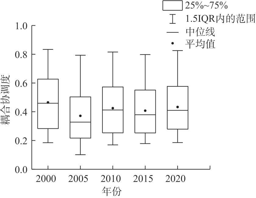
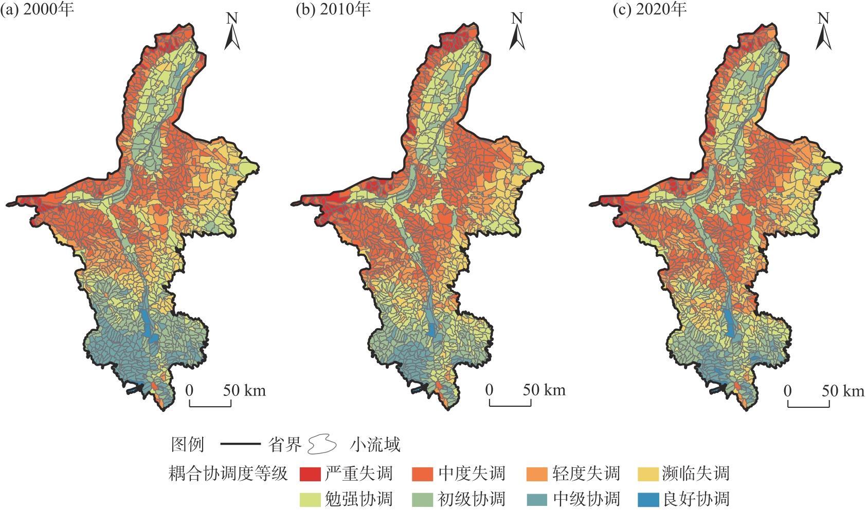
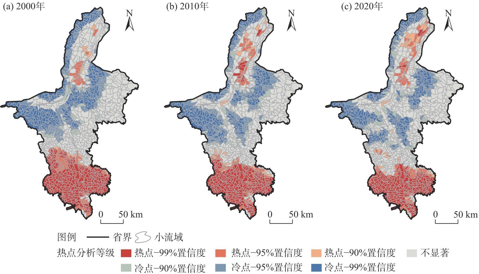
水土资源的耦合协调对于小流域生态系统服务功能的可持续发展具有重要意义。以宁夏小流域为研究单元,采用耦合协调度模型对研究区水土资源耦合协调度进行测度,并采用多尺度地理加权回归模型探究了水土资源耦合协调度的影响因素及空间异质性。 结果表明:(1) 2005—2020年宁夏小流域水土资源耦合协调度从0.37上升到0.43,区域水土资源匹配程度从失调向协调方向发展。(2) 宁夏小流域水土资源耦合协调度呈现出南高北低的空间格局,且2000—2020年南部小流域水土资源耦合协调度的高值区向周边扩展。(3) 宁夏小流域的梯田面积占比、县域可达性和年平均降水量对水土资源耦合协调度会产生显著的正向影响,而年平均气温、植被覆盖度和侵蚀强度对小流域的水土资源耦合协调度会起到显著负向影响;相较于宁夏北部小流域,小流域梯田面积占比和年平均气温对宁夏南部小流域的水土资源耦合协调度影响较大,而县域可达性和年平均降水量对宁夏南部小流域水土资源耦合协调度影响较小。研究结果可为宁夏小流域尺度水土保持措施的科学规划提供参考。
徐建斌 , 曹小曙 . 宁夏小流域尺度水土资源耦合特征及影响因素[J]. 干旱区地理, 2025 , 48(9) : 1531 -1540 . DOI: 10.12118/j.issn.1000-6060.2024.611
The coupling coordination of water and soil resources is of great significance to the sustainable development of ecosystem services in small watersheds. Taking small watersheds of Ningxia, China as the research unit, this study employs the coupling coordination degree model to measure the coupling coordination degree of water-soil resources in the study area. Additionally, the multi-scale geographically weighted regression model is used to explore the influencing factors and spatial heterogeneity of the coupling coordination degree of water-soil resources. The results indicate that: (1) From 2005 to 2020, the coupling coordination degree of water-soil resources in small watersheds of Ningxia increased from 0.37 to 0.43, demonstrating a transition from imbalance to coordination in the regional water and soil resource matching degree. (2) The coupling coordination degree of water-soil resources in small watersheds of Ningxia exhibits a spatial pattern of being higher in the south and lower in the north. Furthermore, from 2000 to 2020, areas of water-soil resources having a coupling coordination degree of high value expanded outward in the southern small watersheds. (3) The proportion of terraced field area, county-level accessibility, and annual average precipitation exert a significant positive impact on the coupling coordination degree of water-soil resources, whereas annual average temperature, vegetation coverage, and erosion intensity have a significant negative impact. The proportion of terraced field area and annual average temperature exert a greater influence on the coupling coordination degree of water-soil resources in the southern small watersheds of Ningxia compared to northern ones, while county-level accessibility and annual average precipitation demonstrate a more significant impact on the same coupling coordination degree in the northern small watersheds of Ningxia than in the southern counterparts. The findings of this study provide a scientific reference for the planning of soil and water conservation measures at the small watershed scale in Ningxia.
表1 数据来源Tab. 1 Data sources |
| 数据 类别 | 指标 | 数据来源 |
|---|---|---|
| 土地利 用数据 | 人均耕地面积/km2·人-1 | 武汉大学中国土地利用/土地覆被数据(https://doi.org/10.5281/zenodo.5210928) |
| 耕地面积比例/% | 武汉大学中国土地利用/土地覆被数据(https://doi.org/10.5281/zenodo.5210928) | |
| 人均建设用地面积 /km2·人-1 | 武汉大学中国土地利用/土地覆被数据(https://doi.org/10.5281/zenodo.5210928) | |
| 水土保持措施数据 | 淤地坝密度/座·km-2 | 宁夏回族自治区水利厅 |
| 梯田面积占比/% | 宁夏回族自治区水利厅 | |
| 生物措施面积占比/% | 宁夏回族自治区水利厅 | |
| 流域社会经济数据 | 流域人口/人 | 世界人口统计数据和研究开放数据库(https://www.worldpop.org/) |
| 流域经济/104元 | 中国科学院资源环境科学数据平台(https://www.resdc.cn/DOI/DOI.aspx?DOIID=33) | |
| 县域可达性/min | ArcGIS软件结合高德地图API获取 | |
| 流域自然环境数据 | 地形起伏度/(°) | 全球变化科学研究数据出版系统(https://geodoi.ac.cn/WebCn/doi.aspx?Id=887) |
| 平均海拔高度/m | 地理空间数据云平台(http://www.gscloud.cn/sources/accessdata/310?pid=302) | |
| 年平均气温/℃ | 中国科学院资源环境科学数据平台(https://www.resdc.cn/DOI/DOI.aspx?DOIID=96) | |
| 年平均降水量/mm | 中国科学院资源环境科学数据平台(https://www.resdc.cn/DOI/DOI.aspx?DOIID=96) | |
| 植被覆盖度/% | 国家青藏高原科学数据中心(https://www.tpdc.ac.cn/zh-hans/data/f3bae344-9d4b-4df6-82a0-81499c0f90f7) | |
| 侵蚀强度/t·km-2·a-1 | 国家青藏高原科学数据中心(https://data.tpdc.ac.cn/en/data/f4593a2d-cd26-45f4-b699-73712eb2d1f3) |
表2 水土资源耦合协调度等级划分Tab. 2 Coupling coordination grades of water-soil resources |
| 耦合协调度 | 协调类型 | 耦合协调度 | 协调类型 |
|---|---|---|---|
| [0.0, 0.1) | 极度失调 | [0.5, 0.6) | 勉强协调 |
| [0.1, 0.2) | 严重失调 | [0.6, 0.7) | 初级协调 |
| [0.2, 0.3) | 中度失调 | [0.7, 0.8) | 中级协调 |
| [0.3, 0.4) | 轻度失调 | [0.8, 0.9) | 良好协调 |
| [0.4, 0.5) | 濒临失调 | [0.9, 1.0] | 优质协调 |
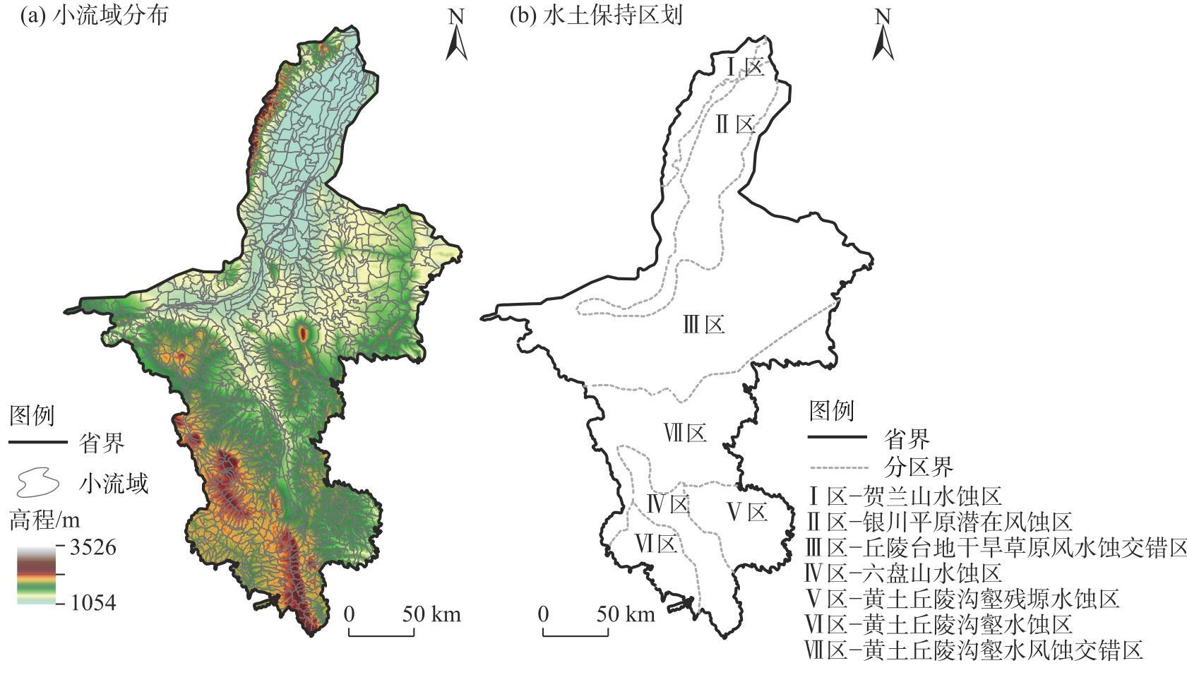
图3 宁夏小流域水土资源耦合协调度空间分布Fig. 3 Spatial distributions of the coupling coordination degrees of water-soil resources in small watersheds of Ningxia |
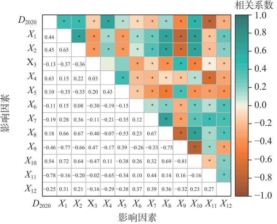
图5 宁夏小流域水土资源耦合协调度与影响因素的相关性分析注:X1为淤地坝密度;X2为梯田面积占比;X3为生物措施面积占比;X4为流域人口;X5为流域经济;X6为县域可达性;X7为地形起伏度;X8为平均海拔高度;X9为年平均气温;X10为年平均降水量;X11为植被覆盖度;X12为侵蚀强度;D2020为2020年小流域水土资源耦合协调度。*、**、***分别表示在P<0.1、P<0.05、P<0.01水平下显著。 Fig. 5 Correlation analysis of the coupling coordination degrees of water-soil resources and its influencing factors in small watersheds of Ningxia |
表3 水土资源耦合协调度的MGWR模型回归结果Tab. 3 Regression results of MGWR model of the coupling coordination degrees of water-soil resources |
| 变量 | 系数平均值 | T统计量 | P值 | 方差膨胀因子 |
|---|---|---|---|---|
| 截距 | 0.931 | 17.167 | 0.000*** | - |
| 淤地坝密度 | -0.033 | -0.129 | 0.897 | 1.738 |
| 梯田面积占比 | 0.000 | 3.048 | 0.002** | 1.698 |
| 生物措施面积占比 | 0.001 | 0.080 | 0.936 | 1.215 |
| 流域人口 | 0.001 | -0.367 | 0.714 | 3.434 |
| 流域经济 | -0.001 | -1.189 | 0.235 | 3.593 |
| 县域可达性 | 0.004 | -6.185 | 0.000*** | 1.224 |
| 地形起伏度 | 0.001 | 2.987 | 0.200 | 2.171 |
| 平均海拔高度 | -0.001 | -4.633 | 0.106 | 5.106 |
| 年平均气温 | -0.026 | -5.266 | 0.000*** | 4.355 |
| 年平均降水量 | 0.001 | 25.264 | 0.000*** | 2.917 |
| 植被覆盖度 | -0.008 | -43.164 | 0.000*** | 1.619 |
| 侵蚀强度 | -0.074 | -10.224 | 0.000*** | 1.480 |
注:*、**、***分别表示在P<0.1、P<0.05、P<0.01水平下显著;MGWR为多尺度地理加权回归。 |
| [1] |
刘彦随, 吴传钧. 中国水土资源态势与可持续食物安全[J]. 自然资源学报, 2002, 17(3): 270-275.
[
|
| [2] |
张恩月, 苏迎庆, 张云枫, 等. 汾河流域水土资源耦合协调格局及驱动因素[J]. 中国沙漠, 2023, 43(3): 169-177.
[
|
| [3] |
|
| [4] |
|
| [5] |
刘彦随, 甘红, 张富刚. 中国东北地区农业水土资源匹配格局[J]. 地理学报, 2006, 61(8): 847-854.
[
|
| [6] |
段春青, 刘昌明, 陈晓楠, 等. 区域水资源承载力概念及研究方法的探讨[J]. 地理学报, 2010, 65(1): 82-90.
[
|
| [7] |
马利邦, 田亚亚, 郭晓东, 等. 基于格网的河西绿洲乡村聚落时空演变及其与水土资源的空间耦合关系[J]. 自然资源学报, 2018, 33(5): 775-787.
[
|
| [8] |
|
| [9] |
张展羽, 司涵, 冯宝平, 等. 缺水灌区农业水土资源优化配置模型[J]. 水利学报, 2014, 45(4): 403-409.
[
|
| [10] |
|
| [11] |
王凌阁, 朱睿, 陈泽霞, 等. 甘肃河西地区 2000—2019 年水土资源耦合协调特征[J]. 中国沙漠, 2022, 42(2): 44-53.
[
|
| [12] |
周鹏, 邓伟, 彭立, 等. 典型山地水土要素时空耦合特征及其成因[J]. 地理学报, 2019, 74(11): 2273-2287.
[
|
| [13] |
孙宝娣, 于德湖, 崔东旭. 流域生态系统服务和水土资源匹配研究进展[J]. 生态学报, 2023, 43(10): 4308-4318.
[
|
| [14] |
封志明, 杨艳昭, 游珍, 等. 基于分县尺度的中国人口分布适宜度研究[J]. 地理学报, 2014, 69(6): 723-737.
[
|
| [15] |
谭琨, 赵祖军, 赵筱青, 等. 喀斯特山区文山市水土资源利用变化特征及耦合研究[J]. 水土保持研究, 2021, 28(4): 324-332.
[
|
| [16] |
|
| [17] |
|
| [18] |
|
| [19] |
|
| [20] |
|
| [21] |
黄明, 张建军, 茹豪, 等. 晋西黄土区不同植被覆盖小流域的产流输沙特性[J]. 中国水土保持科学, 2012, 10(5): 16-23.
[
|
| [22] |
卢炜丽, 张洪江, 杜士才, 等. 重庆四面山地区几种不同配置模式水土保持林生物多样性研究[J]. 山地学报, 2009, 27(3): 319-325.
[
|
| [23] |
樊登星, 余新晓, 贾国栋, 等. 密云水库上游不同土地利用方式下的土壤侵蚀特征[J]. 水土保持通报, 2015, 35(1): 5-8.
[
|
| [24] |
饶良懿, 高磊, 彭芳. 水土保持生态效应评价: 内涵、尺度与方法[J]. 环境生态学, 2020, 2(6): 19-26.
[
|
| [25] |
利辉, 刘铁军, 王少慧, 等. 2001—2021年内蒙古荒漠草原水分利用效率时空变化特征及影响因素研究[J]. 干旱区地理, 2024, 47(6): 993-1003.
[
|
| [26] |
马明德, 李俊杰, 薛晨皓. 宁夏区域发展对环境胁迫的时空演变及驱动机制分析[J]. 干旱区地理, 2024, 47(6): 1061-1072.
[
|
| [27] |
|
| [28] |
丛晓男. 耦合度模型的形式、性质及在地理学中的若干误用[J]. 经济地理, 2019, 39(4): 18-25.
[
|
| [29] |
贾路, 任宗萍, 李占斌, 等. 基于耦合协调度的大理河流域径流和输沙关系分析[J]. 农业工程学报, 2020, 36(11): 86-94.
[
|
| [30] |
程飞飞, 李洪庆, 宋红艳, 等. 沿海城市陆海生态环境质量综合评价与耦合协调度[J]. 生态学报, 2024, 44(9): 3855-3867.
[
|
| [31] |
王冠孝, 王伟, 张娟娟. 乡村旅游与农村人居环境的耦合协调关系及障碍因子诊断——以山西省为例[J]. 干旱区地理, 2024, 47(1): 170-180.
[
|
| [32] |
胡望舒, 洪辉, 周侃, 等. 黄土丘陵区水平梯田与农民收入的关系及原因——以宁夏回族自治区固原市为例[J]. 干旱区地理, 2013, 36(3): 536-544.
[
|
| [33] |
晁永福. 彭阳县水土保持工程建设以奖代补试点成效与经验[J]. 中国水土保持, 2020, 40(5): 65-66.
[
|
| [34] |
罗庆, 王冰冰, 樊新生, 等. 山区县人口分布的时空特征及主要影响因素分析——以河南省嵩县为例[J]. 地理科学进展, 2020, 39(7): 1073-1084.
[
|
| [35] |
赖承义, 左舒翟, 任引. 不同生态修复措施和环境因素对亚热带红壤区针叶纯林坡面水土保持功能的影响[J]. 生态学报, 2021, 41(12): 4913-4922.
[
|
/
| 〈 |
|
〉 |
