
青藏高原东北部实际蒸散发时空变化特征及影响因素
|
卢晗(1998-),男,硕士研究生,主要从事遥感应用与区域规划研究. E-mail: h_lu0123@163.com |
收稿日期: 2024-06-25
修回日期: 2024-08-06
网络出版日期: 2026-03-11
基金资助
国家自然科学基金项目(42171364)
Spatiotemporal variation of actual evapotranspiration and its influencing factors in the northeast Qinghai-Xizang Plateau
Received date: 2024-06-25
Revised date: 2024-08-06
Online published: 2026-03-11
卢晗 , 曾永年 , 王盼成 . 青藏高原东北部实际蒸散发时空变化特征及影响因素[J]. 干旱区地理, 2025 , 48(5) : 753 -764 . DOI: 10.12118/j.issn.1000-6060.2024.395
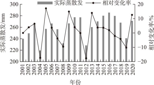
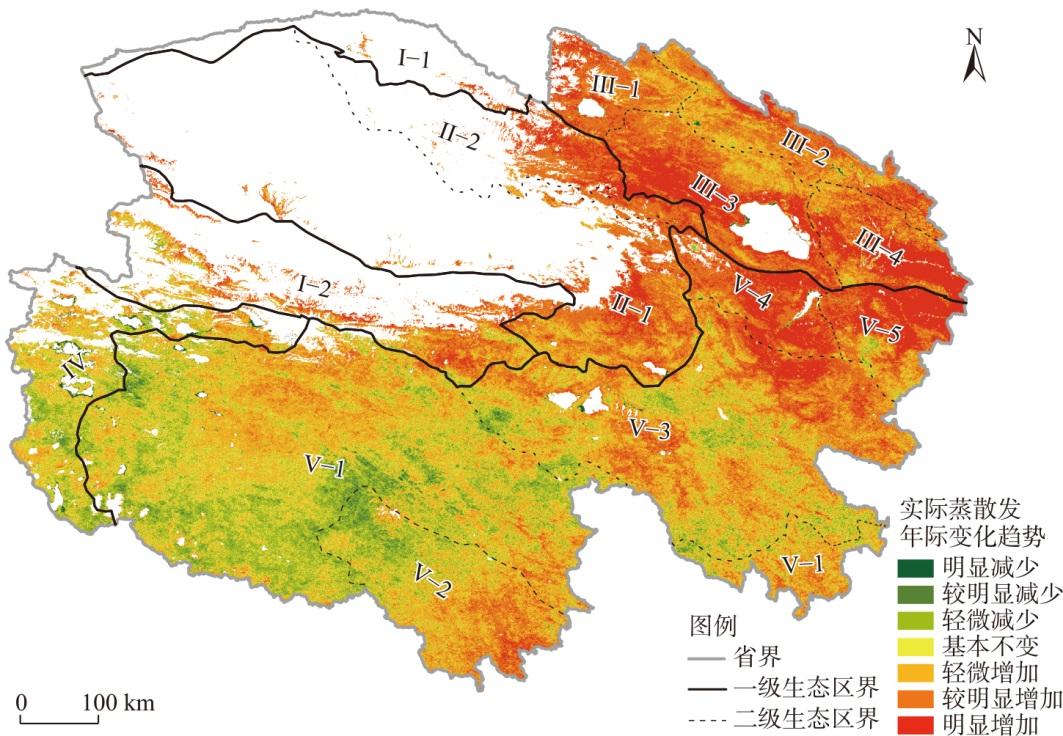
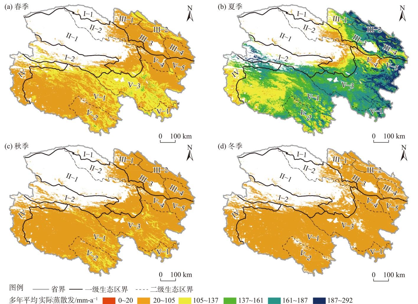
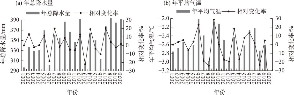
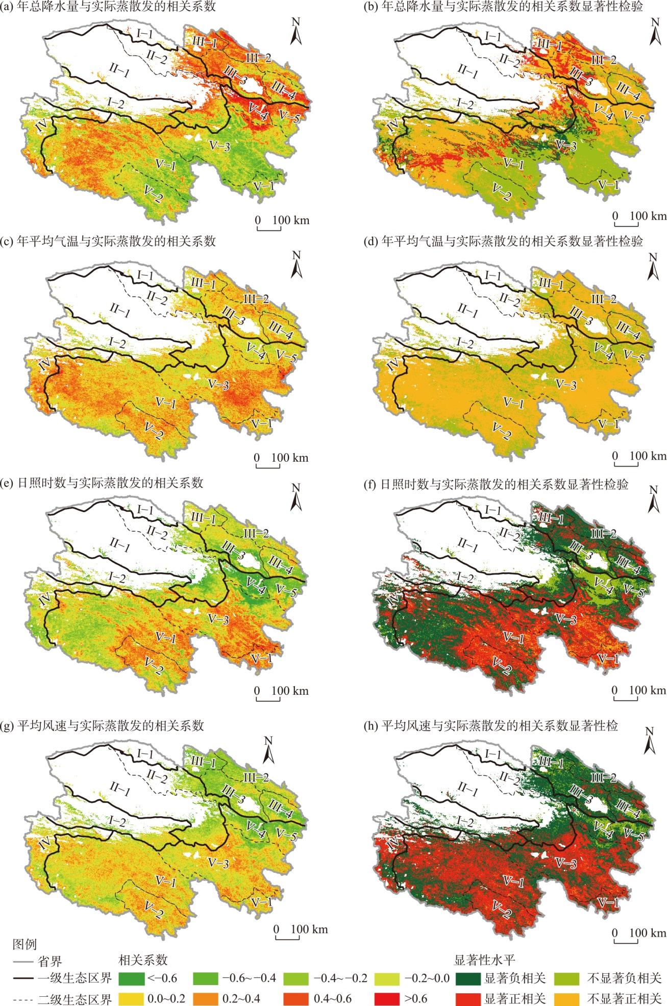
The spatiotemporal characteristics and influencing factors of actual evapotranspiration (ET) in the northeastern Qinghai-Xizang Plateau are crucial for the effective management of regional water resources and the ecological environment. Using Qinghai Province, located in this region, as the study area, this study analyzed actual ET data (MOD16 ET) from 2001 to 2020 to explore the spatiotemporal patterns, variation trends, and influencing factors over the past 20 years. The results indicate the following: (1) The average annual actual evapotranspiration in Qinghai Province from 2001 to 2020 was 260 mm·a-1, showing a fluctuating increasing trend. The fluctuation period also showed an increasing trend, with an average interannual change rate of 2%. Areas where actual ET increased accounts for 69.69% of the total area, and areas where it decreased accounted for 16.51%. Among them, the Qilian Mountains area and the eastern part of the river source ecological zone exhibited an increasing trend in actual ET. The seasonal variation of actual ET in Qinghai Province was significant, with the maximum in summer, the minimum in winter, and similar values in spring and autumn. (2) The average actual ET in Qinghai Province from 2001 to 2020 showed a spatial distribution characteristic of being low in the northwest and high in the southeast. There were large differences in actual ET among various ecological zones in Qinghai Province, with the Three River Source area and the Qilian Mountains area exhibiting the largest actual ET distribution, and the Qaidam Basin ecological zone had the smallest actual ET. The actual ET of the main vegetation cover types was ranked as follows: shrubland>forest land>grassland>arable land. (3) The fluctuating changes in actual ET in Qinghai Province from 2001 to 2020 were basically consistent with temperature variations. The increase in actual ET largely corresponded to the increasing trend of precipitation fluctuations, but the peak lagged behind changes in precipitation. (4) Actual ET was positively correlated with annual average temperature, annual total precipitation, sunshine duration, and average wind speed in 73%, 56%, 43%, and 44% of the total study area, respectively. Temperature and precipitation were the primary controlling factors of actual ET, whereas sunshine duration and wind speed also exerted notable influences. There were significant regional differences in the factors affecting the changes in actual evapotranspiration.
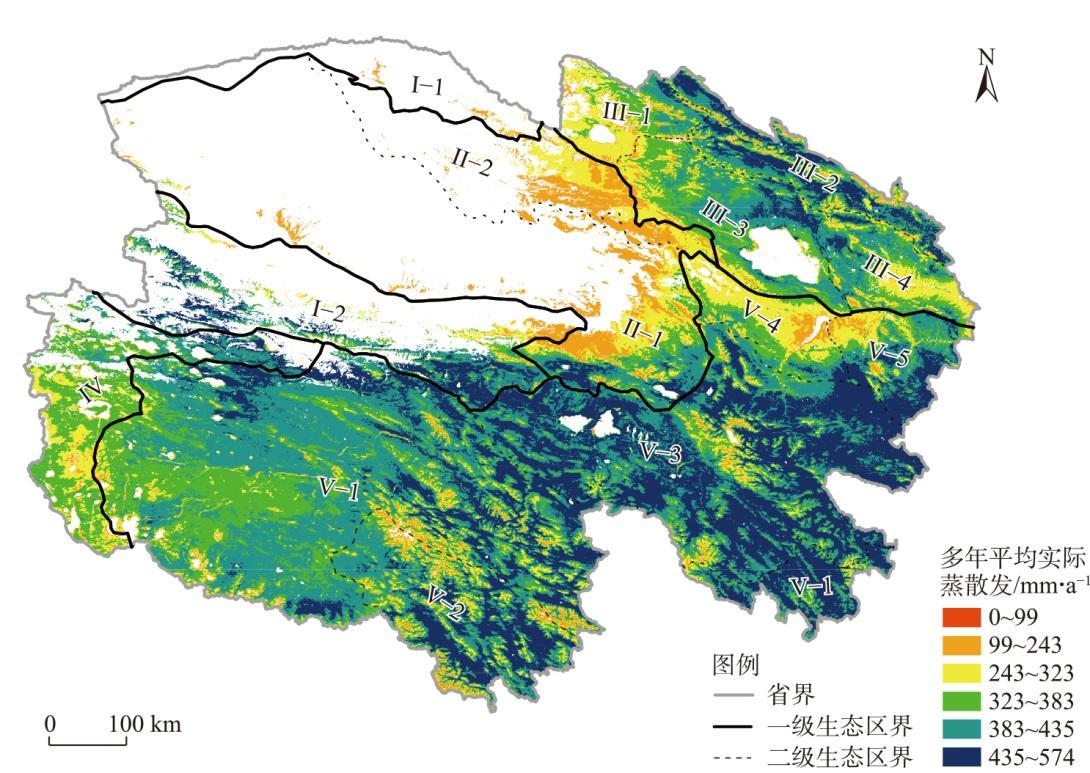
图6 2001—2020年青海省多年平均实际蒸散空间分布Fig. 6 Spatial distributions of annual average actual evapotranspiration in Qinghai Province from 2001 to 2020 |
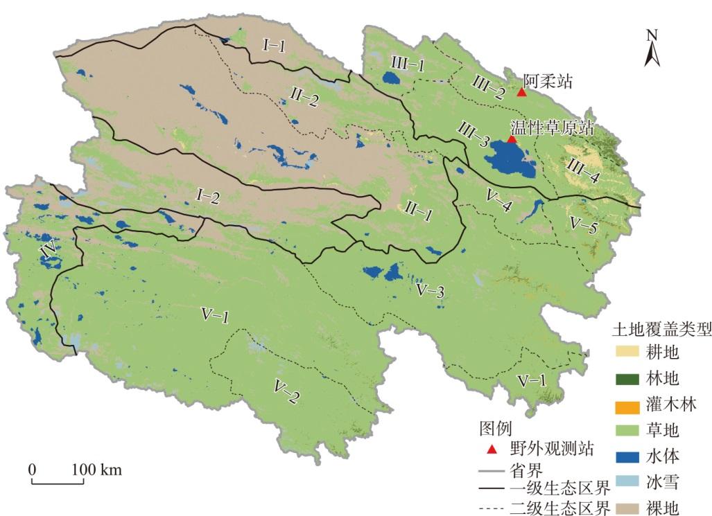
表1 青海省各生态区多年平均实际蒸散发Tab. 1 Annual average actual evapotranspiration of each ecological region in Qinghai Province |
| 一级生态分区 | 多年平均实际蒸散发/mm·a-1 | 二级生态分区 | 多年平均实际蒸散发/mm·a-1 |
|---|---|---|---|
| 帕米尔-昆仑山-阿尔金山生态区(I) | 91.56 | 阿尔金山荒漠生态区(I-1) | 6.76 |
| 昆仑山东段高寒荒漠草原生态区(I-2) | 119.58 | ||
| 柴达木盆地生态区(II) | 64.75 | 柴达木盆地荒漠生态区(II-1) | 60.95 |
| 柴达木盆地东北部山地高寒荒漠草原生态区(II-2) | 79.03 | ||
| 祁连山生态区(III) | 326.58 | 西祁连山高寒荒漠草原生态区(III-1) | 252.54 |
| 东祁连山云杉林高寒草甸生态区(III-2) | 393.24 | ||
| 青海湖湿地及上游高寒草甸生态区(III-3) | 310.18 | ||
| 湟水谷地农业生态区(III-4) | 344.11 | ||
| 北羌塘高寒荒漠草原生态区(IV) | 227.95 | - | - |
| 江河源生态区(V) | 388.82 | 长江源高寒草甸草原生态区(V-1) | 380.58 |
| 澜沧江源高寒草甸草原生态区(V-2) | 385.92 | ||
| 黄河源高寒草甸草原生态区(V-3) | 420.32 | ||
| 共和盆地高寒草原生态区(V-4) | 299.57 | ||
| 海东-甘南高寒草甸草原生态区(V-5) | 381.76 |
注:-表示北羌塘高寒荒漠草原生态区内不设立二级生态分区。 |
| [1] |
张圆, 贾贞贞, 刘绍民, 等. 遥感估算地表蒸散发真实性检验研究进展[J]. 遥感学报, 2020, 24(8): 975-999.
[
|
| [2] |
冯飞, 姚云军, 张彦彬, 等. 基于MOD16产品的三江平原蒸散量时空分布特征分析[J]. 生态环境学报, 2015, 24(11): 1858-1864.
[
|
| [3] |
王焕, 梅再美. 贵州省地表蒸散发时空变化及其与气候因子的关系[J]. 水土保持研究, 2020, 27(5): 221-229.
[
|
| [4] |
刘昌明, 张丹. 中国地表潜在蒸散发敏感性的时空变化特征分析[J]. 地理学报, 2011, 66(5): 579-588.
[
|
| [5] |
张晓涛, 康绍忠, 王鹏新, 等. 估算区域蒸发蒸腾量的遥感模型对比分析[J]. 农业工程学报, 2006, 22(7): 6-13.
[
|
| [6] |
|
| [7] |
|
| [8] |
|
| [9] |
|
| [10] |
|
| [11] |
|
| [12] |
|
| [13] |
吴桂平, 刘元波, 赵晓松, 等. 基于MOD16产品的鄱阳湖流域地表蒸散量时空分布特征[J]. 地理研究, 2013, 32(4): 617-627.
[
|
| [14] |
张猛, 曾永年, 齐玥. 基于MOD16的洞庭湖流域2000—2014年地表蒸散时空变化分析[J]. 农业工程学报, 2018, 34(20): 160-168.
[
|
| [15] |
王卓月, 孔金玲, 李英, 等. 基于MOD16的银川平原地表蒸散量时空特征及影响因素分析[J]. 水文地质工程地质, 2021, 48(3): 53-61.
[
|
| [16] |
范雪梅, 罗贤, 季漩, 等. 基于MOD16产品的怒江流域中上游蒸散发分布特征研究[J]. 水土保持通报, 2019, 39(2): 199-205.
[
|
| [17] |
孔晶晶, 昝梅, 张振东. 新疆玛纳斯河流域蒸散发时空分布格局研究[J]. 灌溉排水学报, 2021, 40(10): 117-124.
[
|
| [18] |
褚荣浩, 李萌, 谢鹏飞, 等. 安徽省近20年地表蒸散和干旱变化特征及其影响因素分析[J]. 生态环境学报, 2021, 30(6): 1229-1239.
[
|
| [19] |
温媛媛, 赵军, 王炎强, 等. 基于MOD16的山西省地表蒸散发时空变化特征分析[J]. 地理科学进展, 2020, 39(2): 255-264.
[
|
| [20] |
马建琴, 陈阳, 郝秀平, 等. 2001—2019年河南省地表蒸散发时空变化及其影响因素[J]. 水土保持研究, 2021, 28(5): 134-141.
[
|
| [21] |
贺添, 邵全琴. 基于MOD16产品的我国2001—2010年蒸散发时空格局变化分析[J]. 地球信息科学学报, 2014, 16(6): 979-988.
[
|
| [22] |
杨艳颖, 毛克彪. 中国蒸散时空变化规律及其对耕地旱灾影响研究[J]. 中国农业资源与区划, 2021, 42(9): 36-51.
[
|
| [23] |
邱丽莎, 张立峰, 何毅, 等. 2000—2018年祁连山蒸散发时空变化及影响因素[J]. 水土保持研究, 2020, 27(3): 210-217.
[
|
| [24] |
叶红, 张廷斌, 易桂花, 等. 2000—2014年黄河源区ET时空特征及其与气候因子关系[J]. 地理学报, 2018, 73(11): 2117-2134.
[
|
| [25] |
王军邦, 赵烜岚, 叶辉, 等. 基于贝叶斯模型平均的蒸散遥感产品集成——以三江源国家公园为例[J]. 应用生态学报, 2021, 32(6): 2119-2128.
[
|
| [26] |
赵天玮, 朱文彬, 裴亮, 等. 三江源蒸散发遥感估算及其时空分布特征研究[J]. 遥感技术与应用, 2022, 37(1): 137-147.
[
|
| [27] |
李红阳, 陈天宇, 王圣杰, 等. 1979—2021年新疆昆仑山北坡潜在蒸散时空变化研究[J]. 干旱区地理, 2024, 47(9): 1443-1450.
[
|
| [28] |
马亚丽, 牛最荣, 孙栋元. 河西走廊潜在蒸散发时空格局变化与气象因素的关系[J]. 干旱区地理, 2024, 47(2): 192-202.
[
|
| [29] |
申红艳, 马明亮, 王冀, 等. 青海省极端气温事件的气候变化特征研究[J]. 冰川冻土, 2012, 34(6): 1371-1379.
[
|
| [30] |
刘凤, 曾永年. 2000—2015年青海高原植被碳源/汇时空格局及变化[J]. 生态学报, 2021, 41(14): 5792-5803.
[
|
| [31] |
|
| [32] |
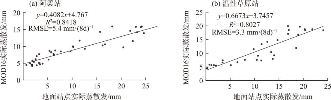
刘绍民, 车涛, 徐自为, 等. 祁连山综合观测网: 黑河流域地表过程综合观测网(阿柔超级站涡动相关仪-2020)[R]. 北京: 国家青藏高原科学数据中心, 2021.
[
|
| [33] |
|
| [34] |
李小雁. 祁连山综合观测网:青海湖流域地表过程综合观测网(温性草原涡动相关仪-2020)[R]. 北京: 国家青藏高原科学数据中心, 2021.
[
|
| [35] |
徐自为, 刘绍民, 徐同仁, 等. 涡动相关仪观测蒸散量的插补方法比较[J]. 地球科学进展, 2009, 24(4): 372-382.
[
|
| [36] |
|
| [37] |
|
/
| 〈 |
|
〉 |